

MT HOOD SNOW FORECAST

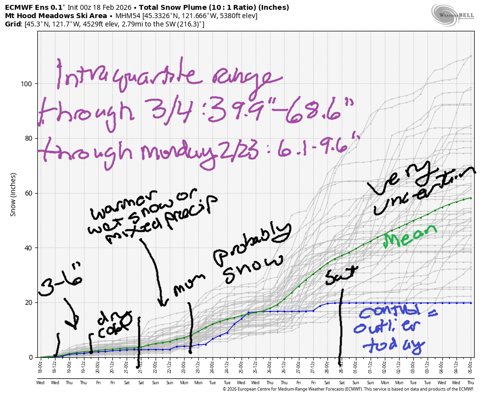
Hey skiers and snowboarders! Slowly, ever so slowly, we’re adding to the snowpack. We’re still suffering – the snowpack on Mt. Hood is 36% of normal, and we’re only at the 2nd percentile. This puts us in “worst snowpack ever” territory. We’ll pick up a bit more snow today into tomorrow followed by a little more over the weekend and more next week. The intraquartile range isn’t spectacular – 6-10” through Monday and 40-69” through March 4th – but it’s infinitely better than straight-up rain, which is NOT in the forecast at this point.
Short term Mt Hood snow forecast
Looking at Wednesday…. the day started mostly cloudy on Mt Hood with flurries, but if you go up in elevation, you’ll find sun on the highest lifts. Nordic: cloudy to start. Light snow moves in midday and continues until Thursday. The snow level will be 500′ in the morning, 1500′ in the afternoon, and 0′ after midnight. Temps max out in the mid 20s at 5000′. About 0.2” water equivalent (WE) is forecast during the day for 2-3” powder. Ditto overnight. Wind will be W 20 during the day, W 15 in the evening, and S 5-10 overnight.
Thursday starts with light snowfall and quickly turns partly cloudy. The snow level will be 0′ in the morning, 1000′ in the afternoon, and 0′ after midnight. Just an inch of snow is forecast for the morning before sunshine appears. Temps max out in the low 20s. Wind will be S 5-10 in the morning, light/variable in the afternoon, and W 20 after midnight.
Extended Mt Hood Snow Forecast
Friday starts sunny and adds high clouds in the afternoon. The free air freezing level will be 0′ in the morning, 1500′ in the afternoon, and 0′ after midnight. Wind: W 20 in the morning, S 5-10 in the afternoon, and S 15-25 overnight.
Weekend weather looks warmer as an offshore system sends warmer air from the south. We could see a trace of wet snow midday Saturday, but the weather looks mostly dry with temps in the low 30s and moderate S wind. Sunday looks similar with a bit more precip possible. While models currently suggest 2-3” snow, it’s possible we could see mixed precip. Cooler temps return on Monday with light to moderate snow forecast for the first half of next week. Uncertainty skyrockets Thursday, so let’s leave it there for now. Happy turns to you!
Was that helpful? I knew it was! Guess what? All of this crucial work – from your personal wind and snow reports to the invaluable TATAS updates – is made possible by my relentless efforts. Maintaining this labor of love isn’t easy. Each daily forecast takes hours. Website hosting, weather model access, and back-end admin work takes time and money. That’s where you come in.
YOUR CONTRIBUTION MAKES A DIFFERENCE
- SUPPORT ACCURATE, HYPER-LOCAL WEATHER FORECASTING
- ENABLE ACCESS FOR ALL, EVEN THOSE WITH LESS MEANS
- SUPPORT A COOL HUMAN WHO WORKS HARD SO YOU CAN PLAY
Take a moment to click one of the buttons below. Donate $19.99 or more (how much does this forecast enhance your life?) and get the email in your inbox. Whether it’s a renewing subscription (auto-renew) or a one-time donation, every contribution makes a real difference. Help me keep this labor of love alive, so we can all continue playing, commuting, and living in the Gorge with peace of mind and the best weather forecasts possible. Thank you!


Hood River, Oregon 97031


GORGE WIND FORECAST
If you’re still seeing yesterday’s and it’s after 9am, try opening this in an incognito window
SHORT-TERM gorge wind forecast
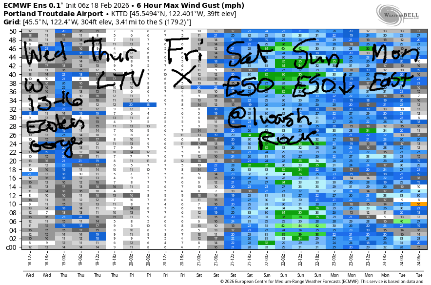
Hi friends! Light to moderate westerlies this morning fade this afternoon. Light, widespread easterlies return on Thursday and are followed by a nearly calm day on Friday. Easterlies return Friday night and persist through the weekend with the possibility of a strong east wind day on Saturday and a strong morning on Sunday.
For Wednesday, we started with pressures of 29.70/29.64/29.61 for light onshore gradients. Strongest wind was Viento (19) and the Hatch (14) with low double digits most places. Expect a brief period of 13-16 from Viento to the Hatch this morning with a shot at the same from Rufus to Arlington. As the next weather system moves in mid-morning, the wind drops off below 10mph. River flow over the last 24 hours was 158-186kcfs, river temp is 41.9F, and high temp forecast is 41.9F.
RIVER FLOW FOR SITES BETWEEN AVERY (EAST OF THE DALLES) AND RUFUS: CLICK HERE FOR JOHN DAY DAM FLOW.
RIVER FLOW FOR SITES BETWEEN STEVENSON AND DOUG’S BEACH (WEST OF THE DALLES): CLICK HERE FOR THE DALLES DAM FLOW

LONGER-TERM gorge wind forecast
Thursday starts with light easterlies (and snow, probably) as a low moves offshore. Expect E 10mph all the way from Iwash to Arlington. After 1pm, the wind turns light westerly at 5-10mph. High temp: 43F with snow possible early and partly cloudy sky later. Friday will be calm. Late in the day, perhaps after sunset, the wind builds to E 30mph. High temp: 43F and partly cloudy.
Stronger east wind, up to 50mph at Iwash, is possible Saturday. Sunday starts similar, but fades to E 25mph in the afternoon. Highs will be in the low 40s Saturday and upper 40s on Sunday. Have fun out there, and stay safe!
BARE BONES HOOD RIVER WEATHER FORECAST
Partly to mostly cloudy this morning with clouds and rain after10am. Snow is likely overnight. Temps start in the low 30s and rise to the low 40s. Light westerlies 79% chance of rainbows. Thursday brings wet snow in the morning (or snain) with snow at higher elevations. Dry weather returns by noon with partly cloudy sky. Temps start in the low 30s and rise to the low 40s. Light easterlies in the morning. Light westerlies later. 44% chance of rainbows. Friday will be cloudy then partly cloudy. Temps start in the upper 20s and rise to the low 40s. Calm wind most of the day. Easterlies in the evening. No rainbows.
TEMIRA’S AWESOME TRAVEL ADVISORY SERVICE
HYPERLOCAL WEATHER FORECAST FOR THE COLUMBIA GORGE
THE DALLES, HOOD RIVER, WHITE SALMON, TROUT LAKE, STEVENSON, CASCADE LOCKS, PARKDALE, ODELL, HUSUM, BZ, MILL A, WILLARD, GOLDENDALE, RUFUS, ARLINGTON, boardman
Good morning, neighbors! Looks like everyone away from the Nch’i Wana is below 32F this morning, which means almost all of you have the potential for icy roads. Be careful out there! I even saw some ice on MY car (HOW DARE THEY?) this morning in the lowlands. Tonight brings our best chance for widespread snowfall so far this season. Dry weather finishes off the week.
Glenwood this morning
It must have been clear in Glenwood this morning, because the thermometer there said 23F. Along the 84/14 corridor, temps are generally in the mid 30s. That doesn’t completely preclude ice on the roads – radiational cooling is a thing – but hopefully ODOT and WSDOT did their deicing thing last night. Up high, above 1000′ or so, you’re likely to encounter trace amounts of snow on the road. So far, there is no sign of !CE on the roads in the Gorge today.
Today’s Gorge weather forecast
After a partly to mostly cloudy start to Wednesday, rain (lowlands) and snow (1000-1500’+) moves in midday. temps max out in the low 40s in the lowlands, and the wind will be W 10mph. Prior to sunset, Parkdale and the south Wasco areas and perhaps Goldendale & Wishram could pick up a trace to an inch of snow. Steadier, moderate, more widespread snowfall moves in overnight. With 850mb temps falling to -6C to -8C overnight, we’re looking at a snow level of 0-1000′.
Thursday’s Gorge weather forecast
Giving the timing and intensity of precip, we’re almost certain to see a trace to 2” down low by Thursday morning (see image). Highest accumulations Wednesday night will be between elevated areas in the western Gorge and Goldendale: 2-4”. Elevated and eastern Gorge areas on the south side (Parkdale to Arlington, including south Wasco, Sherman, and Gilliam Counties) pick up 1-3”. Snow ends by 10am on Thursday. We’re left with sky that clears from west to east. Thursday wind: light and variable. High temp: 43F after a low 30s start.
Extended Gorge weather forecast
Partly cloudy sky Friday morning (SUN!) combines with 850mb temps at -8C for an upper 20s start in the lowlands with colder temps elsewhere. Icy roads are highly likely. With partly cloudy sky sticking around and no precip forecast, temps rise to the low 40s. Wind: calm becoming E 30mph near Iwash (dick) Rock late in the day.
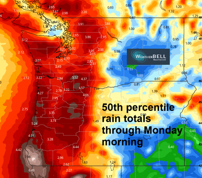
Somewhat warmer weather is forecast for the weekend along with strong east wind and intermittent light rain. Beyond the weekend, nothing particularly concerning is in the cards – temps return to normal, and the possibility of lowland snow disappears from the forecast. Safe travels. -TATAS
HEY! DON’T STOP READING! Is this community-focused forecast helpful to you? It sure is! It takes me a couple hours a day to write. Please join your friends and neighbors in contributing to keep it going. Venmo: @thegorgeismygym PayPal: twomirrors@gmail.com USPS: Temira / PO Box 841 / Hood River, Oregon 97031 You can test out the forecast subscription for a few days for free by signing up below. Easy! Do it!
JONES BEACH, SAUVIE ISLAND, & COAST FORECAST
ON WINTER VACATION UNLESS DESPERATELY NEEDED.
