

MT HOOD SNOW FORECAST

Hey skiers and snowboarders! Chaos struck Mt Hood last night, and there’s plenty more chaos in the Mt Hood snow forecast for the next few days. We’re looking at snow (yay) today followed by a torrential downpour on Thursday, snow on Friday into Friday night, dry weather on Saturday, and then uncertainty about Sunday’s precipitation type.
Before we dive in… power went out last night at meadows and T-Line, so we don’t have full reports on the wind and precip. That said, in the midnight hour, Meadows reported 49mph gusting to 96mph at the top of Mt. Hood Express. There was a gust to 138mph on Magic Mile at T-Line. As I was writing this, 26 was closed just uphill of Govy due to downed power lines.
Short term Mt Hood snow forecast
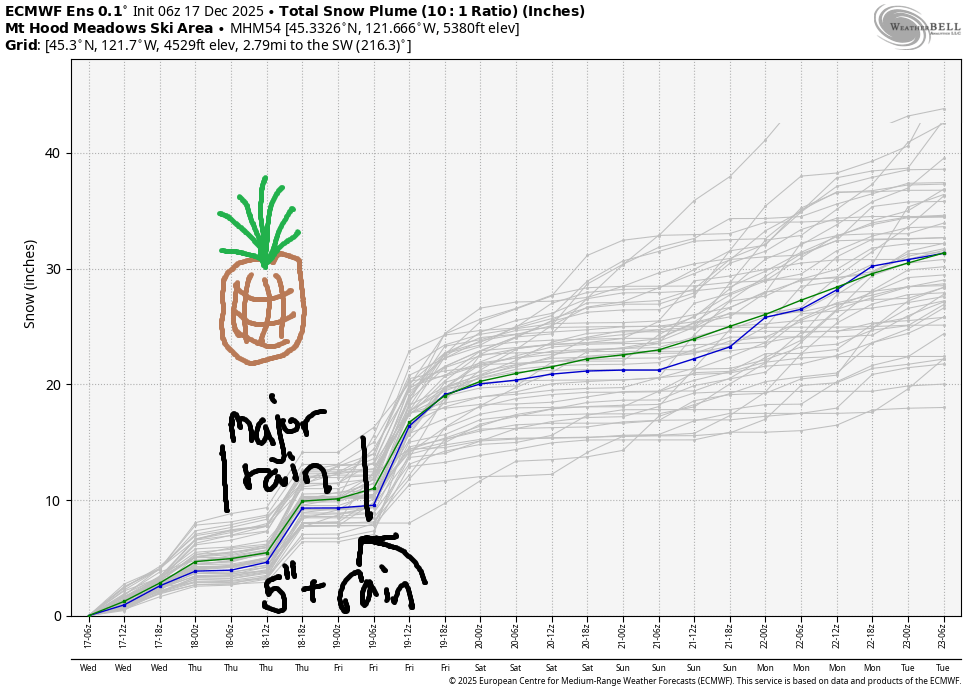
Looking at today, Wednesday, we’ve got snow in the forecast The snow level will be around 2000′ all day. About 0.5” water equivalent (WE) is forecast during the day for 4-6” new snow. Oversnight, a trace is forecast before a brief period of dry weather. Wind will be WSW 45-55 this morning, W 40-45 this afternoon, and S 10-15 after midnight.
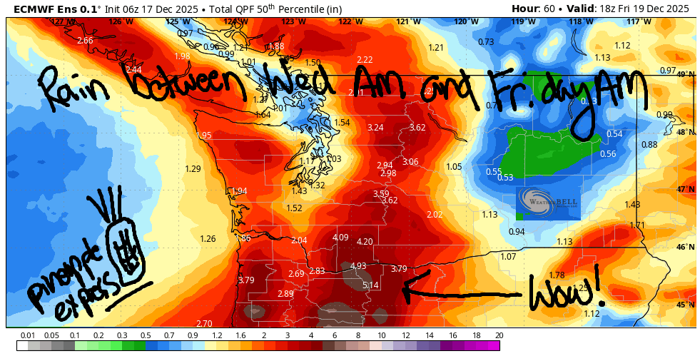
Light snow returns in the wee hours of Thursday. By 4am, dumping wet snow arrives. This persists into the morning, but switches to rain by 10am. Torrential rain pounds Mt Hood all day long – while we could pick up half a foot of snow on the front end, the 5-6” rain will wash it away. Around midnight Thursday, rain switches to snow. 4-7” is possible by Friday morning. Orographic (terrain-enhanced) effects may increase both the rain and snow totals thanks to wind assistance: S 10-15 early, WSW 45-65 in the afternoon, WSW 50-70 in the evening, W 50 around midnight, and NW 30-40 after midnight. Trees may come down, and significant icing on lifts is possible as the snow level drops.
Extended Mt Hood Snow Forecast
On Friday, we’ll have a “normal” Mt. Hood day – light snowfall and moderately strong wind. The snow level will be 2500′ in the morning, 2000′ in the afternoon, and 1500′ after midnight. About 0.2” WE is forecast during the day for 2-3” dry snow. About 0.3” WE arrives overnight for 3-4” more. Wind: NW 30-35 early, W 35 int eh afternoon, and WSW 20-25 after midnight.
Saturday looks mostly sunny after a few lingering early morning flurries. The snow level will be 1500-2500′ with temps in the mid to upper 20s. Wind: W 30ish all day. Models can’t make up their mind about Sunday – we’re expecting light precip, but some ensemble members insist on snow, and some insist on rain. Looking deeper into the future: uncertainty is relatively high about temps, but light to moderate precip is forecast for pretty much every 24 hour period. Fingers crossed it stays cold!
Was that helpful? I knew it was! Guess what? All of this crucial work – from your personal wind and snow reports to the invaluable TATAS updates – is made possible by my relentless efforts. Maintaining this labor of love isn’t easy. Each daily forecast takes hours. Website hosting, weather model access, and back-end admin work takes time and money. That’s where you come in.
YOUR CONTRIBUTION MAKES A DIFFERENCE
- SUPPORT ACCURATE, HYPER-LOCAL WEATHER FORECASTING
- ENABLE ACCESS FOR ALL, EVEN THOSE WITH LESS MEANS
- SUPPORT A COOL HUMAN WHO WORKS HARD SO YOU CAN PLAY
Take a moment to click one of the buttons below. Donate $19.99 or more (how much does this forecast enhance your life?) and get the email in your inbox. Whether it’s a renewing subscription (auto-renew) or a one-time donation, every contribution makes a real difference. Help me keep this labor of love alive, so we can all continue playing, commuting, and living in the Gorge with peace of mind and the best weather forecasts possible. Thank you!


Hood River, Oregon 97031


GORGE WIND FORECAST
If you’re still seeing yesterday’s and it’s after 9am, try opening this in an incognito window
today’s gorge wind forecast
Hi friends! Wow. It sure was windy last night, and the wind will persist for at least part of today. Easterlies return on Thursday along with a torrential downpour (not worth it!), and then we’re back to light/moderate westerlies Friday and Saturday.
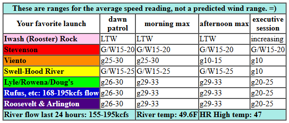
Looking at Wednesday morning, we have pressures of 29.79/29.62/29.51 for 0.17/0.09. Westerlies were 25-35mph depending on where you looked. Get it early if you want areas west of Rowena. By midday, they’ll be below 15mph. Between Lyle and Hermiston, westerlies persist at gusty, up-and-down, instability-influenced, 29-33mph until early afternoon before dropping to the low 20s. Watch for debris in the water. River flow over the last 24 hours was 155-195kcfs, river temp is 49.6F, and high temp forecast is 47F with showers west of The Dalles and sunshine out east, where temps max out in the low 50s.
RIVER FLOW FOR SITES BETWEEN AVERY (EAST OF THE DALLES) AND RUFUS: CLICK HERE FOR JOHN DAY DAM FLOW.
RIVER FLOW FOR SITES BETWEEN STEVENSON AND DOUG’S BEACH (WEST OF THE DALLES): CLICK HERE FOR THE DALLES DAM FLOW

tomorrow’s gorge wind forecast
On Thursday, we’ll see easterlies at 20-25mph at both Iwash (Rooster) and Stevenson to start the day. They’ll peak around 35mph at Iwash and 25mph at Stevenson mid-morning and fade in the afternoon (20-25mph finish at Stevenson, 15mph at Iwash). However… it’ll be absolutely pouring rain all day. High temp: 49F.
extended Gorge wind forecast
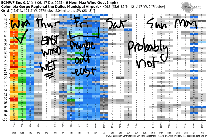
Friday starts with 10mph or so west of The Dalles and 19-22mph east of The Dalles. Afternoon wind drops to 11-14mph out east and holds at 7-10mph west of The Dalles. High temp: 45F with rain in the morning and dry weather later for Hood River. Saturday looks light west of The Dalles and potentially 17-20mph to east. Sunday: the forecast is a bit unclear, so I’ll leave it here for now. Be safe if you’re on the river today – keep watching for debris, and keep an eye on your buddies!
BARE BONES HOOD RIVER WEATHER FORECAST
Rain and wind this morning gives way to showers this afternoon. Temps start in the mid 40s and rise to the upper 40s. Strong westerlies early. Light westerlies later. 100% chance of rainbows (FIRST SPOTTED 7:50AM). Thursday will be torrentially wet. Temps start in the mid 30s and rise to the upper 40s. Light to moderate easterlies. 1% chance of rainbows. Friday will be rainy in the morning and afternoon with a break midday. Temps start in the upper 30s and rise to the mid 40s. Light westerlies. 99% chance of rainbows.
TEMIRA’S AWESOME TRAVEL ADVISORY SERVICE
HYPERLOCAL WEATHER FORECAST FOR THE COLUMBIA GORGE
THE DALLES, HOOD RIVER, WHITE SALMON, TROUT LAKE, STEVENSON, CASCADE LOCKS, PARKDALE, ODELL, HUSUM, BZ, MILL A, WILLARD, GOLDENDALE, RUFUS, ARLINGTON, boardman
Good morning, neighbors! Chaos reigns right now thanks to very strong wind overnight. Trees and power lines are downed across the region – so far I saw a report of Dee Highway closed at Woodworth and Highway 26 closed at Govy. Be careful out there. We also have snow falling at 2000′; the snow level rises to 2500′ this afternoon. More on tonight’s snow level later. While the rain and wind will be fading as the day progresses, plenty of hazards exist right now. One hazard not yet seen this morning: ICE.
Up next in the hazard forecast: torrential rain for the entire Gorge, and especially for areas west of Mosier, all day Thursday. If you can avoid driving to/from the metro area Thursday, do so. Add in a chance for some wet, sloppy snow Thursday morning, and you have an unpleasant commute day.
Let’s look at this morning, shall we? Our friends in Glenwood remain baffled by the warm weather. They started the day at 40 degrees. Everyone was gazing longingly at Mt. Defiance (which you can’t see from Glenwood, but they were trying using x-ray vision, which everyone in Glenwood has) and wondering if it’s time to plant tomatoes. It isn’t, but we can dream.
Today’s weather includes intermittent light rain to Rowena until the afternoon with moderate rain west of Hood River. Temps max out near 47 (west), 50 (The Dalles), and 56 (desert, thanks a lot, adiabatic warming). Wind will be 20-30mph early west of The Dalles with 30-35mph to the east. After noon, the wind falls below 15mph west of The Dalles. East of The Dalles, the wind drops off after 1pm and ends the day at 20-25mph.
A period of mostly clear sky tonight combines with -3C temps at 850mb to drop some locations near or below freezing. Uh oh. If this really happens, we’re going to see widespread wet, sloppy snow (probably above 500-1000′, but potentially mixed in down lower) as Thursday’s Pineapple Express – a strong one – encounters that cold-ish air. The sounding model keeps the temp profile snow-friendly through sunrise or a couple hours later. Can I give you a prediction for snowfall total? No, because it’s going to be right on the edge, but if you’re at 500′ or higher, be prepared! Back to the rain: TORRENTIAL! Even The Dalles is expecting LOTS of rain. Even the desert is expecting lots of rain. Cascade Locks: multiple inches. Mt. Hood and Mt. Adams: 6” or more.
Given all this rain, the following hazards are possible: flooding of streams, creeks, and rivers; landslides and mudslides; hydroplaning; downed trees; rockfall. Seriously, if you can avoid driving through the western Gorge on Thursday, do it. Last piece: 20-30mph wind most of the day near Stevenson and Iwash (wet wiener) Rock. High temps: 49F except out in the desert where the forecast is for mid 50s.
Overnight Thursday, rain tapers off and temps cool. Friday morning weather is…. drizzle through 10am, a dry period midday, and another rain of moderate rain as far east as Biggs in the evening. Passes: snowing – the snow level falls to 2500′. Low temps will be in the mid to upper 30s. High temps: 45F (west), 47F (The Dalles), and 50F (desert).
Cool, dry weather is forecast on Saturday with a chance of icy roads for select locations. Sunday: models are all over the place, and continues to have high uncertainty past Sunday. Let’s leave it there for now. Safe travels. -TATAS
HEY! DON’T STOP READING! Is this community-focused forecast helpful to you? It sure is! It takes me a couple hours a day to write. Please join your friends and neighbors in contributing to keep it going. Venmo: @thegorgeismygym PayPal: twomirrors@gmail.com USPS: Temira / PO Box 841 / Hood River, Oregon 97031 You can test out the forecast subscription for a few days for free by signing up below. Easy! Do it!
JONES BEACH, SAUVIE ISLAND, & COAST FORECAST
ON WINTER VACATION UNLESS DESPERATELY NEEDED.
