

GORGE WIND FORECAST
If you’re still seeing yesterday’s and it’s after 9am, try opening this in an incognito window
today’s gorge wind forecast
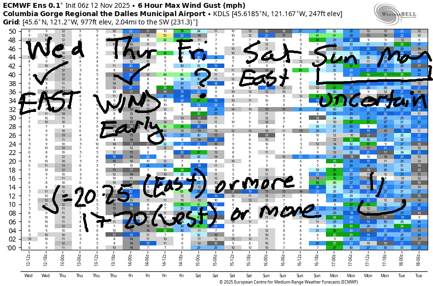
Hi friends! East wind continues for a couple more days. While we’ll have westerlies on Friday, they’re unlikely to be strong enough for wind sports. Easterlies are likely on Saturday. Looking at Sunday, we see model disagreement. The GFS deterministic is not excited about wind. The Euro has a 30-60% chance of wind gusts greater than 20mph. That’s way better than 0% chance! We’ll watch it. In the meantime…
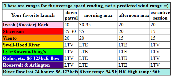
Wednesday kicks off with 0.12 offshore gradient and east wind. Iwash (Rooster) started the day at 40mph, Stevenson started at 27mph, and Viento was at 18mph when I woke up. The wind begins its typical downward slide early. By 1pm, Stevenson and Iwash will be down to 20-25mph. Later: 20mph at Iwash and 15mph at Stevenson. River flow over the last 24 hours was 86-123kcfs, river temp is 54.9F, and high temp forecast is 56F.
RIVER FLOW FOR SITES BETWEEN AVERY (EAST OF THE DALLES) AND RUFUS: CLICK HERE FOR JOHN DAY DAM FLOW.
RIVER FLOW FOR SITES BETWEEN STEVENSON AND DOUG’S BEACH (WEST OF THE DALLES): CLICK HERE FOR THE DALLES DAM FLOW

tomorrow’s gorge wind forecast
Thursday brings another round of east wind, but this one drops even faster! Iwash starts with 35-40mph, and Stevenson starts with 25-30mph. This puts Viento at 20mph or so to start. By 1pm, Iwash will be down to 15mph, and Stevenson will be below 10mph. After that: light and variable for the rest of the day potentially turning light westerly. High temp: 56F.
extended Gorge wind forecast
Friday sees a weak weather system move through. This turns the wind onshore and gives us westerlies at 13-16mph from Avery to Arlington. West of Avery, the wind remains under 10mph. High temp: 54F. Looking at Saturday, we currently have east wind at 20-25mph. Sunday, as I said before, has some potential for strong-enough westerlies. We’ll keep an eye on it as we get closer. Have a great day today!
Was that helpful? I knew it was! Guess what? All of this crucial work – from your personal wind and snow reports to the invaluable TATAS updates – is made possible by my relentless efforts. Maintaining this labor of love isn’t easy. Each daily forecast takes hours. Website hosting, weather model access, and back-end admin work takes time and money. That’s where you come in.
YOUR CONTRIBUTION MAKES A DIFFERENCE
- SUPPORT ACCURATE, HYPER-LOCAL WEATHER FORECASTING
- ENABLE ACCESS FOR ALL, EVEN THOSE WITH LESS MEANS
- SUPPORT A COOL HUMAN WHO WORKS HARD SO YOU CAN PLAY
Take a moment to click one of the buttons below. Donate $19.99 or more (how much does this forecast enhance your life?) and get the email in your inbox. Whether it’s a renewing subscription (auto-renew) or a one-time donation, every contribution makes a real difference. Help me keep this labor of love alive, so we can all continue playing, commuting, and living in the Gorge with peace of mind and the best weather forecasts possible. Thank you!


Hood River, Oregon 97031


MT HOOD SNOW FORECAST

Hey skiers and snowboarders! A few days ago, this weekend was looking great. I was talking to one of the groomers from Teacup, and we were excited to get another round of skiing. Now: not so much. Not only has the temp forecast climbed, but the precip forecast has declined. Models do still insist on colder weather, cold enough for snow at 5000′, starting around the 17th and persisting for at least a week. Fingers crossed!
Looking at Wednesday, we have an overcast day for Mt. Hood. The free air freezing level (FAF) will be 10,000′ all day and 9000′ overnight. Wind: SW 10-15mph this morning, lighter this afternoon, building to SSW 15-30 overnight. Rain is forecast Thursday. The snow level will be 9000′ in the morning, 10,000′ in the afternoon, and 7000′ overnight. About 0.1” rain is forecast during the day followed by 0.2” rain overnight. Wind: SSW 15-30 in the morning, SW 25-45 midday, and WSW 20-25 after midnight.
A little drizzle persists on Friday under (eventually) clearing sky. High clouds return overnight. The snow level will be 7000′ in the morning, 5500′ in the afternoon, and 8000′ overnight. Wind: WSW 20-25 all day and SW 10-15 overnight. Looking beyond Saturday, we start to see a lot of range in the potential precipitation amounts. As of this morning, the weather does look too warm for snow through the weekend. But there’s definitely hope starting around the 17th, the beginning of next week. I should probably get my onboarding completed for my ski resort job, eh? See you on the snow soon!
BARE BONES HOOD RIVER WEATHER FORECAST
Clouds today. Temps start in the upper 40s and rise to the low 50s. Light easterlies. No rainbows. Thursday will be drizzly in the morning and partly cloudy in the afternoon. Temps start in the mid 40s and rise to the mid 50s. Light easterlies. 19% chance of rainbows. Friday will be cloudy with a chance of drizzle in the afternoon. Temps start in the low 40s and rise to the mid 50s. Light westerlies. 35% chance of rainbows.
TEMIRA’S AWESOME TRAVEL ADVISORY SERVICE
HYPERLOCAL WEATHER FORECAST FOR THE COLUMBIA GORGE
THE DALLES, HOOD RIVER, WHITE SALMON, TROUT LAKE, STEVENSON, CASCADE LOCKS, PARKDALE, ODELL, HUSUM, BZ, MILL A, WILLARD, GOLDENDALE, RUFUS, ARLINGTON, boardman
Good morning, neighbors! Sounds like folks with a view to the north saw quite the show of the aurora last night. We’ll have another shot this evening – the sky does look to be mostly cloudy, but we might get enough gaps to see the glow. In other weather news… Nothing too intense or out of the ordinary for November. Dry Wednesday, rainy Thursday, a little drizzle Friday… Models develop more uncertainty this weekend. Sunday will almost certainly have rain, but Saturday may be dry. Maybe. Wnat to raise the possibility of dry weather? Practice kindness and compassion and reflect on those instances where you didn’t. They’re normal, by the way. I have lots of them! I bet you didn’t know that kindness and love could shift the weather. They can’t shift the external weather, but they can certainly shift the weather in your heart and in the hearts of those around you!
Glenwood this morning
Looking at Glenwood this morning, it’s 40 degrees, but nobody cares. Why? Being close to Mt. Adams and close to a view of the aurora, the entire town is out staring at the sky and has been all night long. Nobody slept, and everyone’s jittery from all the coffee and energy drink slushies from the Glenwood Store that they drank last night. They drank slushies, not the store, just to be clear. But from what I hear from folks in High Prairie, it was worth it to be up watching! Maybe the rest of us will have a chance tonight!
Today’s Gorge weather forecast
Weather this morning will be cloudy to the west and partly to mostly cloudy to the east. So far this morning, no reports of ice on the local roads in The Dalles or Hood River. You can follow Hood River Latino Network’s Facebook page for updates on the changing icy road conditions. Temps are running in the mid to upper 40s most places. They rise to the mid 50s today. Near Iwash (RELEASE THE FILES!) Rock, east wind will be 40mph this morning and 20mph this afternoon. Poor Stevenson, the most consistently windy place in the Gorge and maybe on the planet, east wind will be 30mph this morning and 20mph this afternoon. GIVE IN, RESIDENTS OF STEVENSON. TAKE UP A WIND JOHNNY SPORT! (kidding – I know WJ sports are really expensive and most people can’t afford them)
Tonight’s aurora forecast and Thursday’s Gorge weather forecast
Overnight into Thursday, we have a darn good chance of the aurora borealis. It’s all a matter of getting enough cloud breaks. Looking at the cloud model (see image), it appears there will be a break in both the mid and high clouds from about Rowena east to Goldendale. North side of the river looks less cloudy than the south side. Overnight temps: mid 40s. Drizzly arrives early Thursday morning and extends as far east as The Dalles. We could see heavy enough rain – I’d call it “moderate” – to add stress to your drive into/from the metro area. Commuter wind near Iwash (WHERE ARE MY HEALTHCARE SUBSIDIES?) Rock will be 35-40mph in the morning and light/variable in the afternoon. High temp: mid 50s.
Extended Gorge weather forecast
Other than the possibility of a tiny bit of drizzle form Hood River to The Dalles in the afternoon, Friday looks dry. Temps start in the low 40s and end up in the 54-58F range. Wind: light westerly. Sky: cloudy to the west, clear near The Dalles, and partly cloudy to the east. This puts the highest chance of rainbows right over The Dalles. Weekend: Saturday is more likely to be dry than Sunday, but there’s a chance of rain both days.
Passes for the next few days: the only time the snow level drops below 6000′ will be Friday afternoon and night, and there’s not much snow forecast. The situation changes up there starting Monday, when models agree on cooler temps and a lower snow level. Okay, that’s good for now. I hope it is, anyway. Safe travels. -TATAS
HEY! DON’T STOP READING! Is this community-focused forecast helpful to you? It sure is! It takes me a couple hours a day to write. Please join your friends and neighbors in contributing to keep it going. Venmo: @thegorgeismygym PayPal: twomirrors@gmail.com USPS: Temira / PO Box 841 / Hood River, Oregon 97031 You can test out the forecast subscription for a few days for free by signing up below. Easy! Do it!
JONES BEACH, SAUVIE ISLAND, & COAST FORECAST
ON WINTER VACATION UNLESS DESPERATELY NEEDED.
