

Support it with a contribution!

Thank you for using this forecast. Writing it takes 60-120 minutes a day; I can only keep it going with your generous financial support. Make a contribution or subscribe and get it in your inbox with bonus material. What’s that cost? Not $99 a year. Nope. Not $49. Contribute $19.99 or more, and you’re on the list for a year. People are added to this list on Thursday and Sunday. Thanks for your patience! Click below to contribute and keep the forecast going for everyone, nearly every day.
Click here to use your PayPal
Venmo: @theGorgeismyGym
Snail Mail: Temira Lital, PO Box 841, Hood River, Oregon 97031
(note: I am not a non-profit entity. The only way to accept credit cards with a user-defined amount is to use the ‘donate’ button. Thanks for understanding!)
Auto-renewing subscription. New! Awesome!
The Forecast
Today’s Gorge Wind – these are ranges for the average speed, not a predicted wind range. =)
Your favorite beach
Dawn
Patrol
9am-
11:30a
11:30a-
3pm
3pm-
dusk
Rooster Rock
overcast
sky
buns
cry!
Steven’s Locks
5-10
10-14
15-18
15-18
Viento
24-28
20-23
20-23
20-23
Swell-Hood River
15-18
18-21
18-21
18-21
Lyle to Doug’s
LTW
5-10
10-13
18-21
Rufus, etc.
LTV
LTV
LTV
LTV
Roosevelt & Arlington
LTV
LTV
LTV
LTV
Patrol
11:30a
3pm
dusk
Gorge Wind Forecast
Another day of moderate westerlies Wednesday gives way to a nuker of a day on Thursday. You’ll need to shift your attention eastward on Friday, as the western Gorge will be in the clouds and rain. As of this morning, the extended forecast for the weekend also suggests you’ll be headed east of Hood River for the strongest (but still moderate) wind.
Wednesday’s pre-dawn gradients were 0.10 and 0.03. Viento, as always, started the day windy (28), the Swell-Mosier stretch was 15-19, and all other locations were under 10mph and variable. By mid-morning, we’ll see 15-18 at Stevenson, 20-23 at Viento, and 18-21 from Swell to Mosier. That wind holds through the day (more or less) and fills in to Doug’s in the evening. River flow is 109kcfs, river temp is 72F, and high temp forecast is 92F with smoky haze.
You’ll want your tough person outfit for Thursday. Models bring a deep low to the east side from California, they have an offshore cold front knocking down temps by 10-15F in the west, and they have just enough high pressure off the coast to lend some synoptic-scale power to the wind. Forecast: 22-26 to start from Viento to Mosier with 10-13 at Stevenson and the eastern Gorge. By late morning, westerlies build to 27-31 from Stevenson to The Dalles. From then on, it’s all up (with the caveat of possible surface-based thunderstorms in the eastern Gorge). Models take us into the rarely-seen periwinkle wind zone for 30-35 Stevenson to Hood River and 30-40 east to Biggs in the evening. Arlington: 24-28.
Before you dash out to Rufus, The Wall, or Arlington, check the radar and satellite for thunderheads – the SPC has the region under a marginal risk for severe storms. Even if the storms don’t happen, wind quality and speed could be affected. Never leave wind to find wind. Given the very strong wind, please consider taking safety precautions such as a helmet, PFD, and watchful partner. High temp: 82.
Clouds and drizzle push into the western Gorge on Friday morning. High temps fall into the mid 70’s for Hood River. Clouds stick around all day, and the western Gorge responds with westerlies at 7-10 in the morning and 10-13 in the afternoon. If you head east of the low clouds, meaning east of The Dalles, you’ll find 20-23 in the morning and 25-28 in the afternoon. Weekend wind will strongest east of Mosier; the western Gorge will likely hold in the low teens. Drive a bit east for low to mid 20’s both days, subject to change as the picture sharpens. Have a great day on the river!
Coast, Jones, Coast
Coast (north/central/south, waves. Wind direction north unless otherwise noted. Swell forecast from NWS.) Wednesday: 15-20/10-15/N to 15, SW 2′ at 17 seconds. Thursday: SW5/W5-10/N10-20, W 5′ @ 10. Friday: LTW/LTNW/N20-25+, W 4′ @ 10. Jones Wednesday: 20-23. Thursday: 16-19. Friday: 8-11. Sauvie’s Wednesday: 13-16. Thursday: 12-15. Friday: calm.
Mt. Hood Weather forecast
On vacation unless some wintry weather happens.
Hood River Weather Forecast
Clear sky and smoke haze sticks around all day. Temps will be in the upper 60’s early and low 90’s later. Moderate westerlies. No rainbows. Thursday will be increasingly high overcast. Temps will be in the low-mid 60’s early and low 80’s later. Moderate to strong westerlies early becoming very strong to nuking in the evening. Chance of thunder east of the Cascades. 0.1% chance of rainbows. Friday looks drizzly or sprinkly in the morning. Cloudy weather starts the day and mostly cloudy weather ends it. Temps will be in the low-mid 60’s early and mid 70’s (yay – open windows all day) later. Light westerlies. 98% chance of rainbows.
Looking for a complete Columbia Gorge forecast? Looking for more humor in your weather? Obscenities? You’re looking for my TATAS: Temira’s Awesome Travel Advisory Service on Facebook.
Cycling
SDS (Whoopdee, Underwood), BLC, HFM, DGS, and Kreps Land (Hospital Hill) are now closed until the end of fire season. It is also vital that people respect this closure to maintain positive relationships between the landowners and trail users. DNR land in Eastern Washington (Buck Creek / Nestor Peak) is all closed to recreation due to fire danger.
Open trails: Post, Falls Creek, Lewis River, Sandy Ridge, Columbia Hills, Gorge 400, Plains of Abraham / Ape Canyon. 44 Road: Eightmile, Fifteenmile, Bottle Prairie, Dog River, Superconnector, Cedar, Knebal, Cooks Meadows, 450 to the top, Gunsight, Underhill. Siouxon and Huffman Peak are “temporarily closed” due to wildfire last year.
Maple Road in Post Canyon is closed. DO NOT drive past the closed signs. If you do so, you will jeopardize TRAIL access for the entire summer. This is the road that runs to the west, just north of the Binns/Riorden intersection. Also, the trail from the bottom of Post Canyon to Seven Streams Staging Area is now closed. It’s on private land. Respect the closure.
Local Events
IFPL 3 restrictions west of Highway 35 went into effect on 7/16. No more motorized use in Post Canyon trails. Mountain View Cycles women’s ride is every Thursday, bottom of Post at 5:30pm. They have an all-genders ride at 6pm on Wednesday, end of the pavement on Post Canyon Road. Their shop road ride leaves at 9am on Saturday for a 2 hour ride. Dirty Fingers has the Post n’ Pint on Thursday evenings at 5:30pm from the shop. They also have the women’s Post n’ Pinot Wednesday evening at 5:30pm from the shop. Oregon E-Bikes has ladies’ rides at 7:30am Sunday and Monday. The Small Boat Group does paddles every Thursday evening at 6pm at the Hatchery.
Other weekly events. Tuesday night there’s meditation with the Pacific Hermitage Monks at 5:15 (1 hour) and 6:30 (30 minutes followed by a talk) at Yoga Samadhi in White Salmon. In-person meditation is on “pause” due to the recent Covid surge. It will happen on the Pacific Hermitage YouTube page at 6:30. Triathlon practice with the Tri Club is Tuesday at 6pm at West Mayer State Park. Sailboat races happen Wednesday night from the Hood River Marina. There are also lesser races on Friday nights. Cheno’s workout is every Saturday at 10am at the Ferment Lawn in Hood River ($10). Families in the Park starts August 5th at Jackson Park and runs for several weeks on Thursday evening.
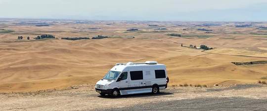
Sprinter Van of the Week!
 Click here for the Sprinter Van map of the world!!!
Have an awesome day!
Click here for the Sprinter Van map of the world!!!
Have an awesome day!
