

MT HOOD SNOW FORECAST

Hey skiers and snowboarders! HOORAY!!!!! It dumped on Mt Hood over the last 24 hours!! Over the last day, Timberline picked up 16”, Meadows is reporting 13”, and Teacup says they have a foot of new. Snow quality, given temps in the low 20s, should be awesome. Don’t forget that the snowpack is shallow – approach your pow turns with caution. We have another foot-plus of new snow on the way over the next 24 hours, and then we enter a dry period Friday and Saturday, when resorts are going to be super-duper busy. Light rain (SAD) is forecast overnight Saturday into Sunday morning – hopefully it’ll be as light as models suggest and won’t mess up the snow quality. Beyond that: warm, sunny and dry for a while, most likely.

Short term Mt Hood snow forecast
It will be neither warm, nor sunny, nor dry on Wednesday. Nope. It’s a storm skiing day! The snow level will be around 2000′ all day and will fall to 500-1000′ overnight. During the day, we’re expecting 0.7” water equivalent (WE) for 7-9” new powder. Overnight, another 0.7” WE is in the cards for 8-12” new; those higher numbers are thanks to cold temps and orographic assistance. Wind: W 40 this morning, SW 25-40 midday, WNW 30 this afternoon, and NW 35-40 this evening and overnight. That wind direction and strength could potentially have some impacts on lifts late in the day; it’s right on the edge for speed+direction chaos.
Thursday brings orographic (terrain-enhanced) snow flurries during the morning. Another weak system brings light snowfall from afternoon into the night. The snow level will be 500-1000′ in the morning, 1500-2000′ in the afternoon, and 1500′ after midnight. About 0.1” WE is expected early morning for an inch of new. Another 0.1” to 0.2” WE is forecast in the afternoon for an inch or two more. Ditto overnight: 1-2” new snow. Snow quality should be dry powder. Temps will be warming throughout the 24 hour period: upper teens to low 20s early and low 30s overnight. Wind: WNW 35-40 early, WNW 35 in the afternoon, and W 20 overnight. That’s just enough wind to potentially impact some lifts.
Extended Mt Hood Snow Forecast
A few flurries Friday morning give way to partly high overcast sky. Temps will be warming. The free air freezing level rises from 1500′ in the morning to 6000′ in the afternoon to 8000′ overnight with temps rising to the mid/upper 30s. Wind: W 20 in the morning, WSW 10 in the afternoon, and SW 10-20 overnight.
Saturday will be partly high cloudy and dry during the day. A trace of rain is forecast overnight. The free air freezing level will be 8000′ during the day and 6000′ overnight with temps rising to the low 40s. Wind: SW 10-20 all day and W 25 after midnight. Sunday starts with a little drizzle and turns partly cloudy. Temps: upper 30s. Wind: W 20-25mph.
Beyond Sunday, we’re (probably) looking at an extended period of warm, mostly dry weather. Something for everyone in this forecast – powder for y’all today, windy, cold weather Thursday, and sunshine for Friday and Saturday. See you on the snow soon!
Was that helpful? I knew it was! Guess what? All of this crucial work – from your personal wind and snow reports to the invaluable TATAS updates – is made possible by my relentless efforts. Maintaining this labor of love isn’t easy. Each daily forecast takes hours. Website hosting, weather model access, and back-end admin work takes time and money. That’s where you come in.
YOUR CONTRIBUTION MAKES A DIFFERENCE
- SUPPORT ACCURATE, HYPER-LOCAL WEATHER FORECASTING
- ENABLE ACCESS FOR ALL, EVEN THOSE WITH LESS MEANS
- SUPPORT A COOL HUMAN WHO WORKS HARD SO YOU CAN PLAY
Take a moment to click one of the buttons below. Donate $19.99 or more (how much does this forecast enhance your life?) and get the email in your inbox. Whether it’s a renewing subscription (auto-renew) or a one-time donation, every contribution makes a real difference. Help me keep this labor of love alive, so we can all continue playing, commuting, and living in the Gorge with peace of mind and the best weather forecasts possible. Thank you!


Hood River, Oregon 97031


GORGE WIND FORECAST
If you’re still seeing yesterday’s and it’s after 9am, try opening this in an incognito window
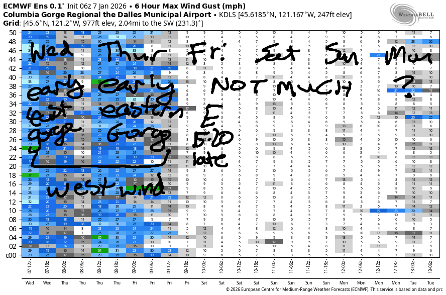
SHORT-TERM gorge wind forecast
Hi friends! A couple days of marginal westerlies are on tap. Prior to dawn Wednesday, we had westerlies around 20mph in the eastern Gorge. A potentially stronger round of early-morning westerlies is planned for Thursday. After that, we fall into a light/variable pattern for a few days before maybe/maybe not seeing easterlies next week.
Wednesday starts with pressures of 29.91/29.85/29.77 and west wind. Speed was under 15mph everywhere – it’s dropped since I woke up. Models suggest we’ll stay under 15mph all day west of Rufus. Midday brings the potential for a few hours of gusty 18-22mph west wind between Philippi Canyon and Threemile. By afternoon, that’ll be down to 13-16mph. River flow over the last 24 hours was 171-212kcfs, river temp is 43.0F, and high temp forecast is 44F with on-and-off rain.
RIVER FLOW FOR SITES BETWEEN AVERY (EAST OF THE DALLES) AND RUFUS: CLICK HERE FOR JOHN DAY DAM FLOW.
RIVER FLOW FOR SITES BETWEEN STEVENSON AND DOUG’S BEACH (WEST OF THE DALLES): CLICK HERE FOR THE DALLES DAM FLOW

LONGER-TERM gorge wind forecast
Thursday starts with westerlies at 10-13mph from Stevenson to The Dalles with 24-27mph from Avery to Hermiston. West of The Dalles, the wind stays light. Out east, there will be a slow fade throughout the day. Get it early for strongest results. High temp: 43F with clouds to the west and partly cloudy sky to the east.
Friday starts calm. As high pressure builds inland, easterlies build to 15-20mph at Stevenson and Iwash (Rooster) Rock. High temp: 47F under partly high overcast sky after a cloudy start. Not much wind is forecast Saturday or Sunday. In yesterday’s forecast, we had models excited about easterlies next week. They’ve backed off some. So, we’ll have to wait and see. If you get out on the river, dress warmly, have an emergency plan, and keep an eye on your buddies!
BARE BONES HOOD RIVER WEATHER FORECAST
Sprinkles this morning, rain this afternoon. Temps start in the mid 30s and rise to the mid 40s. Light westerlies. 98% chance of rainbows. Thursday will be drizzly early then sprinkly. Temps start in the mid 30s and rise to the low 40s. Light westerlies. 98.5% chance of rainbows. Friday will be cloudy then high cloudy. Temps start in the upper 30s and rise to the upper 40s. Calm wind early. Light westerlies later.
TEMIRA’S AWESOME TRAVEL ADVISORY SERVICE
HYPERLOCAL WEATHER FORECAST FOR THE COLUMBIA GORGE
THE DALLES, HOOD RIVER, WHITE SALMON, TROUT LAKE, STEVENSON, CASCADE LOCKS, PARKDALE, ODELL, HUSUM, BZ, MILL A, WILLARD, GOLDENDALE, RUFUS, ARLINGTON, boardman

Good morning, neighbors! We didn’t pick up snow last night, but thanks to colder air arriving with the next system, we’re likely to have a little more snow in our higher zones tonight. A pattern change arrives late Thursday as high pressure attempts to consolidate its grip on power via the use of dry weather and an inversion. RESIST!
Glenwood this morning
Checking in with Glenwood this morning… we have 34 degrees. As best I can tell, our inhabited zones didn’t pick up snow last night. They’ll have to wait until tonight. It does appear we have frozen ground out and about, which means we have icy roads out and about. Be careful out there. No confirmed signs yet of the other kind of ¡CE-y roads, but we definitely had one (black Dodge Durango or Jeep, 711JFE) headed this way around 3:30pm yesterday, and nobody knows where it went. Hide and seek: ON!
Today’s Gorge weather forecast
Today’s weather starts off showery as far east as Hood River. After a semi-break mid-morning, the next system arrives. Heavy rain starts up west of Hood River around 10am and fucks with your drive all the way into late evening. We’ll have moderate rain all the way to the Arlington Equilateral Triangle starting around 4pm. Even south Wasco County picks up some drizzle this afternoon. Today’s wind will be 10mph west of John Day Dam with 20mph to the east. Highs rise to the mid 40s in the lowlands with the snow level around 2000′.
Thursday’s Gorge weather forecast
Overnight into Thursday, the snow level falls to 1000′ as temps at 850mb drop from -4C to -7C. All the bulls on Kreps land wrap their tails around their nuts to keep them warm. All the mean are jealous and wish they had a built-in ball-warmer. The incoming cold air sets up our snow-prone areas for 1-3”, highest to the west. Whom am I talking to? Willard, Mill A, Trout Lake, Snowden, Parkdale, Underwood – 1-3” for you. Trace to 2”: High Prairie, Glenwood, BZ, Stabler, Appleton, elevated Mosier, and potentially Odell + Heights of Hood River and maybe White Salmon and Husum too.
For the rest of Thursday… lowlands start in the mid 30s and rise to the low 40s. Icy roads are likely for many but not all. Showers taper off early morning and return in the afternoon, but we’ll have mostly cloudy sky all the way from west to east all day. By afternoon, the snow level will rise to about 2000′, giving most of us rain-not-snow. West wind accompanies the day: 10mph west of The Dalles and 20-25mph east of The Dalles.
Extended Gorge weather forecast
A few sprinkles prior to dawn on Friday give way to a cloudy, upper-30s start. Low and mid clouds burn off and leave us under partly high overcast sky with filtered sun in the afternoon. In response, temps rise to the upper 40s. Wind will be calm to start then easterly at 15-20mph in the usual spots: Stevenson, Iwash (dick) Rock, Home Valley. Dry weather is forecast all day Saturday with a Nothing in the morning and sun in the afternoon. Drizzle is forecast overnight into Sunday. After that: probably dry for a while with warm weather aloft and cooler, but not cold, weather below. If we’re lucky, and I think we might be, we’ll have clear sky for much of this dry period. More on that later. Safe travels. -TATAS
HEY! DON’T STOP READING! Is this community-focused forecast helpful to you? It sure is! It takes me a couple hours a day to write. Please join your friends and neighbors in contributing to keep it going. Venmo: @thegorgeismygym PayPal: twomirrors@gmail.com USPS: Temira / PO Box 841 / Hood River, Oregon 97031 You can test out the forecast subscription for a few days for free by signing up below. Easy! Do it!
JONES BEACH, SAUVIE ISLAND, & COAST FORECAST
ON WINTER VACATION UNLESS DESPERATELY NEEDED.
