

MT. HOOD WEATHER FORECAST
Hey skiers and snowboarders! Sorry for the late forecast today – I woke up late again. It’s Wednesday, and we have about half a foot of snow in the forecast over the next 24 hours. For the rest of the week, we’ll have intermittent light snowfall, temps in the teens and low 20s, and excellent grooming of the packed powder and hardpack variety. Models are about 50% in for heavier snowfall for the middle of next week, although there could be some mixed precip in there, and models are about 70% for heavier precip of some sort about 10 days out. But let’s get back to today:
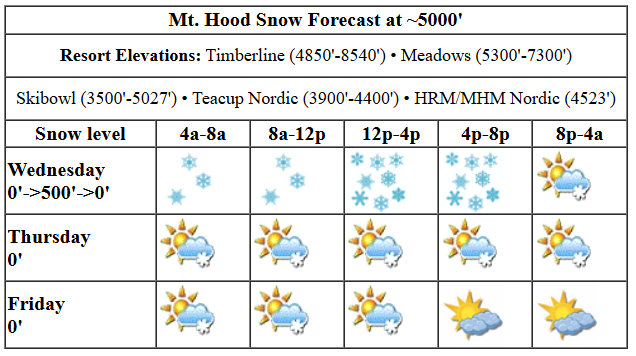
Snow was just getting started as I was writing this forecast, and the snow level was 0′ in the Gorge (it’s snowing at my place!). The snow level hangs around 0′ all morning, rises to 500′ or so this afternoon, and falls back to 0′ tonight. With the 850mb temp forecast at -7C pretty much all day, we’re looking at temps in the upper teens at 5000′. During the day, 0.2” water equivalent (WE) is forecast, for 2-3” dry powder. Overnight, another 0.3” WE is in the cards, for 3-4” additional light powder. That should finish up by midnight and leave the sky partly cloudy. Wind: SW 15-20 this morning, SW 20-30 this afternoon, and light SW after midnight.
Partly cloudy sky Thursday morning adds clouds in the afternoon as a system to the south pushes just far enough north. This system might drive some easterly orographic snowfall during the day, but totals for the 24 hour period should be 1” or less. Probably less. The snow level will be 0′ all day near Mt. Hood with temps at 5000′ in the teens in the morning and low double digits in the afternoon. Wind: light SW most of the day becoming E 20 overnight.
A system moves inland to the south on Friday but (probably) doesn’t bring much snow to Mt. Hood. Maybe flurries interspersed with sun breaks. The snow level will be 0′ in the morning, 500′ in the afternoon, and 0′ after midnight. Wind: E 20 in the morning, NW 20-30 in the afternoon, and W 20-25 in the evening and night.
Light snowfall, a few inches perhaps, is forecast on Saturday with the snow level around 0-1000′. Wind: 20mph out of the west. Sunday bring trace snowfall with a shot at a few sunbreaks in the afternoon, maybe. Light wind. Things then get quite uncertain – models hint at colder weather for the first half of next week, and they’re about 50% in for some sort of snow or mixed precip event on Tuesday. Uncertainty continues for the rest of next week. About 70% of the ensembles like the idea of heavy precip sometime at the end of next week (around the 16th), so we’ll watch that closely to see what develops. In the meantime… there’s some stellar groom up there and excellent Nordic conditions, especially for classic (blue wax). Go get yourself some time on the snow!
Liking this forecast?
Was that helpful? I knew it was! Guess what? All of this crucial work – from your personal wind and snow reports to the invaluable TATAS updates – is made possible by my relentless efforts. Maintaining this labor of love isn’t easy. Each daily forecast takes hours. Website hosting, weather model access, and back-end admin work takes time and money. That’s where you come in.
YOUR CONTRIBUTION MAKES A DIFFERENCE
- SUPPORT ACCURATE, HYPER-LOCAL WEATHER FORECASTING
- ENABLE ACCESS FOR ALL, EVEN THOSE WITH LESS MEANS
- SUPPORT A COOL HUMAN WHO WORKS HARD SO YOU CAN PLAY
Take a moment to click one of the buttons below. Donate $19.99 or more (how much does this forecast enhance your life?) and get the email in your inbox. Whether it’s a renewing subscription (auto-renew) or a one-time donation, every contribution makes a real difference. Help me keep this labor of love alive, so we can all continue playing, commuting, and living in the Gorge with peace of mind and the best weather forecasts possible. Thank you!


Hood River, Oregon 97031


GORGE WIND FORECAST

Hi friends! It’s snowing. I know that won’t stop some of you from getting on the water if you can. Mother Nature’s protecting you by keeping the wind light today. We start with pressures of 29.84/29.88 for a light offshore gradient. Easterlies will be 15mph at Stevenson this morning and light at Iwash (Rooster). Iwash turns westerly at 10-15mph this afternoon while Stevenson holds at 10mph out of the east. River flow over the last 24 hours was 89-127kcfs, river temp is 39.38F, and high temp forecast is 38F with light snowfall all day.
Thursday brings easterlies at 25-30mph at Iwash in the morning, 35mph midday, and 25-30mph in the afternoon. At Stevenson, the day starts with 15-20mph, rises to 25mph, and holds. High temp: 39F with partly cloudy sky and snow on the hills as your backdrop. Friday starts with E 15mph at Stevenson. As a low moves into central Oregon, the wind turns westerly at 15-18ish from Stevenson all the way to Arlington. We could see 17-20 at the Hatch. High temp: 39F. Stay warm out there, and keep an eye on your buddies!
BARE BONES HOOD RIVER WEATHER FORECAST
Light snowfall today maybe switching to snain this afternoon and then light snowfall in the evening. Temps start in the low 30s and rise to the mid 30s. Light easterlies. No rainbows. Thursday will be Nothing then cloudy. Temps start in the upper 20s and rise to the mid 30s. Light easterlies. No rainbows. Friday will be cloudy with a little snow possible but not guaranteed. Temps start in the mid 20s and rise to the upper 30s. Light easterlies in the morning. Moderate westerlies later. 1% chance of rainbows.
TEMIRA’S AWESOME TRAVEL ADVISORY SERVICE (HYPERLOCAL GORGE WEATHER FORECAST)
Good morning, neighbors! It’s not a huge snowstorm, but there’s snow on the ground out there for many of you. I have a trace here in Hood River, and I saw a report of 2” for Cascade Locks. More snow is forecast today for many of us. Next “interesting” thing to happen will be snowfall Friday daytime for South Wasco and Sherman Counties, but that’ll only be a 3 or so on the 10 point “interesting” scale. Next chance of hitting a score higher than 5/10 comes next Tuesday when about 50% of the ensemble members bring in impactful precipitation amounts.
Let’s check in with Glenwood. It’s 27 degrees there this morning, several degrees warmer than many other places, and the dewpoint is 21F. Looks like they had a trace of snow overnight. Glenwood may be the center of the universe, and today’s starting temp is right near the Gorge-area mean. Now we have TATAS Executive Order Of The Day: in all-caps writing using my red Sharpie, I do hereby declare the implementation of financial incentives for nearby landowners to proposed and completed low-income housing in order to reduce instances of NIMBYism and allow for smoother paths to completion for said low-income housing.
TODAY
On to today’s weather: SNOW! Light and intermittent snowfall this morning picks up late morning. Heaviest snowfall will be 10am-10pm for areas west of Hood River and 1pm to 10pm for folks to the east. Snow total guesses: 3-6” for Mill A, Underwood, Trout Lake, Stabler, Carson, Snowden, Husum, BZ, Parkdale (maybe a little more), Odell, elevated parts of Hood River and Mosier, White Salmon, and anyone else I missed in those zones. 2-4” for Appleton, Lyle, elevated parts of The Dalles, High Prairie, and the lower elevations of Hood River and Mosier and the Bingen/White Salmon area. In the lowlands from The Dalles to Amayah’s (the location formerly known as Biggs), 1-2”. SW/Sherm: trace to a inch with the highest totals near Dufur. Temps max out in the mid to upper 30s today which could lower those snow totals in the lowlands and cause a switch from snow to snain along the river, especially to the east where snowfall rates will be lower. Wind today: light easterly becoming calm or very light westerly in the evening.
THURSDAY
Overnight, temps fall back into the 20s as easterlies pick up and drag cooler air back into the Gorge. A system to the south of us may shove precip just far enough north for light snowfall during the day from Hood River eastward. SW/Sherm are right in the bullseye for this, but with precip forecast to be very light, snowfall totals should be an inch or less, even if it snows all day, which looks likely. Other than that… we’ll be dry. Easterlies rise to 30mph near Iwash and Stevenson, and temps max out in the mid to upper 30s along the river. That’s just enough wind to temps a few wacky Wind Johnnies out there into the 39 degree Nch’i Wana.
FRIDAY
The same large-scale setup as Thursday sends some light, steady snowfall to SW/Sherm on Friday morning. Areas way out east along the Columbia could pick up heavier snowfall depending on where the band of precip sets up. For the rest of us: dry and cloudy in the morning with partly cloudy sky for the west side in the afternoon and continued clouds to the east. Morning temps will be in the 20s, and afternoon highs, thanks to the potential for west wind, rise to 40 or so. Wind: easterly at 15mph in the usual spots in the morning with westerlies at 15-20mph in the afternoon from Stevenson to Arlington.
SATURDAY AND BEYOND
Another round of light snowfall or snain is possible on Saturday with minimal impacts. In other words, the weather will be great for supporting your immigrant neighbors and supporting keeping families together at the demonstration at Rite Aid in The Dalles at 11am. Cold, dry weather is forecast for Sunday and Monday. Things get a lot more interesting, and a lot less certain, come Tuesday. I always vote for snow. Hopefully you’ll join me in voting for the more “fun” scenario for Tuesday. Models then really like the idea of temps dropping 5-10 degrees for the middle of next week, and then models are about 70% on board for a return to precip the following weekend. I’m not even going to try and guess at the p-type for that time period, because it really depends on initial conditions going into the transition from dry/cold to warmer/wetter. We’ll just keep an eye on this and see how it evolves. Safe travels. -TATAS
HEY! DON’T STOP READING! Is this community-focused forecast helpful to you? It sure is! It takes me a couple hours a day to write. Please join your friends and neighbors in contributing to keep it going. Venmo: @thegorgeismygym PayPal: twomirrors@gmail.com USPS: Temira / PO Box 841 / Hood River, Oregon 97031 You can test out the forecast subscription for a few days for free by clicking this link: https://subscribepage.io/YhevGc
