

GORGE WIND FORECAST
If you’re still seeing yesterday’s and it’s after 9am, try opening this in an incognito window
today’s gorge wind forecast
Hi friends! I’m waking up slowly this morning despite getting up early. But the wind isn’t waking up slowly – it’s already game on out on the river! If we can avoid the worst impacts of thunderstorms and instability, it’ll be game on here in the Gorge through at least next Monday. Big, big days are possible in this six-day window if everything lines up just right. Beyond Monday, uncertainty increases and the Gorge wind forecast is naught but a guess, although there are some indications of lighter wind for the latter part of next week. Maybe.
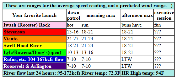
Looking at Wednesday morning, we have pressures of 30.09/29.97/29.96 for onshore gradients of 0.12 (PDX-DLS) and 0.01 (DLS-PSC). No marine clouds were present in the metro area or the Gorge. Early wind, according to iWind/iKite sensors, was 17-20mph from Swell to Hood River with 24-27mph at Viento. Other locations west of The Dalles were reading 13-16mph, and launches to the east were reading 7-10mph. Models knock gradients down this afternoon, so get it this morning. And get it this morning because thunderstorms may impact the wind later.
You’ll find 21-24mph from Swell to Mosier early. Stevenson picks up to 18-21mph mid-morning, and the Lyle-Rowena zone climbs to 14-17mph. Westerlies drop at the Hatch late morning or early afternoon and fill in at 18-21mph from Stevenson to Doug’s. Then we run into a problem: atmospheric instability. Thunderstorms are possible this afternoon into tomorrow, and that could shut down the wind. If you see those storms building, get off the river. Getting struck by lightning would suck. River flow over the last 24 hours was 95-172kcfs (104-167kcfs at Rufus), river temp is 72.3F (poor salmon), and high temp forecast is 94F for Hood River (unless clouds interfere).
RIVER FLOW FOR SITES BETWEEN AVERY (EAST OF THE DALLES) AND RUFUS: CLICK HERE FOR JOHN DAY DAM FLOW.
RIVER FLOW FOR SITES BETWEEN STEVENSON AND DOUG’S BEACH (WEST OF THE DALLES): CLICK HERE FOR THE DALLES DAM FLOW

tomorrow’s gorge wind forecast
All sorts of uncertainty exists on Thursday. To start, we’ll have elevated instability and the possibility of thunderstorms. This brings uncertainty about cloud cover, and that brings uncertainty about high temps across the Cascades. Between the Euro and GFS, huge differences exist in the wind forecast: the GFS gives us 26-29mph+, but the ECMWF only calls for 20-23mph. Ensembles are little help, as their data point is The Dalles and they tend to under-predict Hatch wind. Thursday’s not even a day where I can say “get it early because afternoon thunder” because the instability is elevated and will be present in the morning. Your best bet is probably Viento-Mosier early – that’s the best I can give you! Forecast highs: 82F on the west side and 98F in the desert.
extended Gorge wind forecast
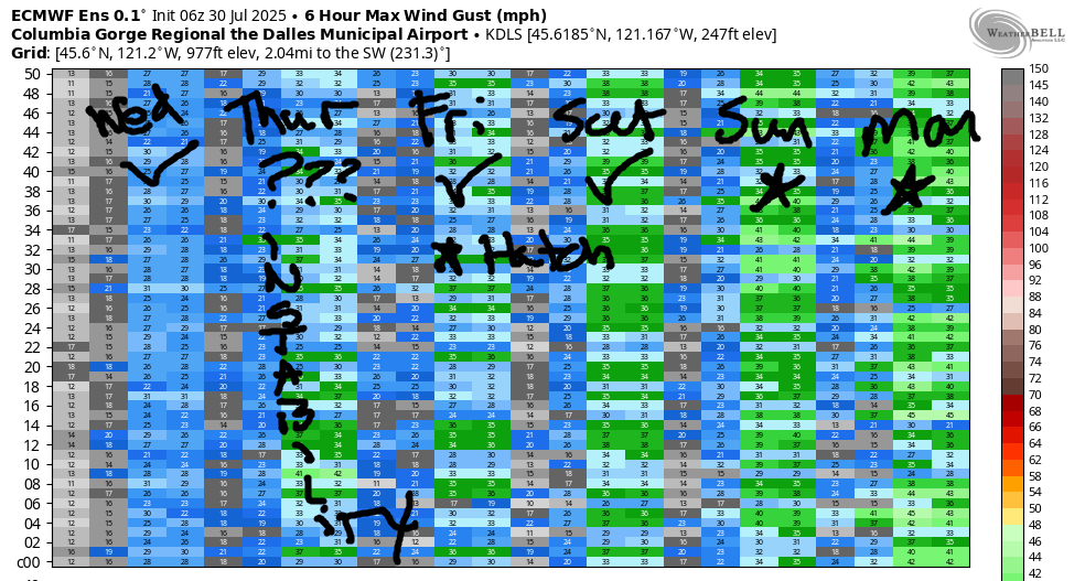
Instability remains for the desert on Friday, but the west side should stabilize. Models have the Hatch at 24-27mph+ to start the day (TJ’s Dawn Patrol is ON!). Afternoon probably knocks the wind down to 18-22mph on the west side and drives it up to 26-29mph from Mosier to Arlington. That said… if the morning marine clouds linger longer than expected, we’ll have an all-day shredfest from Viento to Mosier.
While there’s some uncertainty in the ensembles for the weekend as far as strength of wind, there’s a big “YES” for Saturday, Sunday, and Monday. As of right now, Sunday and Monday look like the two biggest days, and they both have potential to send you scrambling to the Rufus stretch of the river. It’ll be nice to have everyone spread out instead of concentrated at the Hatch! Have fun out there, folks. I’ll see you on the Nch’i Wana!
Was that helpful? I knew it was! Guess what? All of this crucial work – from your personal wind and snow reports to the invaluable TATAS updates – is made possible by my relentless efforts. Maintaining this labor of love isn’t easy. Each daily forecast takes hours. Website hosting, weather model access, and back-end admin work takes time and money. That’s where you come in.
YOUR CONTRIBUTION MAKES A DIFFERENCE
- SUPPORT ACCURATE, HYPER-LOCAL WEATHER FORECASTING
- ENABLE ACCESS FOR ALL, EVEN THOSE WITH LESS MEANS
- SUPPORT A COOL HUMAN WHO WORKS HARD SO YOU CAN PLAY
Take a moment to click one of the buttons below. Donate $19.99 or more (how much does this forecast enhance your life?) and get the email in your inbox. Whether it’s a renewing subscription (auto-renew) or a one-time donation, every contribution makes a real difference. Help me keep this labor of love alive, so we can all continue playing, commuting, and living in the Gorge with peace of mind and the best weather forecasts possible. Thank you!


Hood River, Oregon 97031


JONES BEACH, SAUVIE ISLAND, & COAST FORECAST
Wind northerly unless otherwise indicated. For coast, it’s North/Central/South with the “central” at approximately Florence. Swell forecast from NWS for central coast. Jones: westerly unless otherwise stated. Sauvie Island: northerly unless otherwise stated. Coast Wednesday: NNW15-20/NNW15/N25-30, W swell 2′ at 16 seconds plus a tsunami warning. Thursday: NNW10-15/15/25-30, W 2′ @ 7. Friday: 10-15/15-20/30, W 2′ @ 7. Jones Wednesday: 23-26. Thursday: 16-19. Friday: 20-23. Sauvie Island Wednesday: 15-18 (unless thunderstorms). Thursday: 13-16. Friday: 9-12.
BARE BONES HOOD RIVER WEATHER FORECAST
Mostly clear this morning. Chance of thunderstorms this evening. Temps start in the upper 60s and rise to the mid 90s. Moderate westerlies. 3% chance of rainbows. Thursday brings mostly cloudy sky with a chance of thunderstorms. Temps start in the mid 60s and rise to the low 80s. Strong westerlies. No rainbows. Friday will be mostly clear. Temps start in the low 60s and rise to the low 80s. Strong westerlies. No rainbows.
TEMIRA’S AWESOME TRAVEL ADVISORY SERVICE
HYPERLOCAL WEATHER FORECAST FOR THE COLUMBIA GORGE
THE DALLES, HOOD RIVER, WHITE SALMON, TROUT LAKE, STEVENSON, CASCADE LOCKS, PARKDALE, ODELL, HUSUM, BZ, MILL A, WILLARD, GOLDENDALE, RUFUS, ARLINGTON, boardman
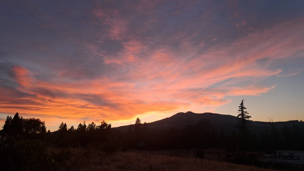
Good morning, neighbors! Thanks to the fact that we’re far inland, we’re not under a tsunami warning this morning! That’s something! Many of us are under a heat advisory, and lots of us have a shot at thunderstorms today and tomorrow. By the weekend, the weather settles down, cools off, and turns rather windy. With instability present for the next few days, we have potential for spectacular sunrises and sunsets. Last night was awesome. More color is on the way!
GLENWOOD THIS MORNING
I’m sure you’re excited to hear all the details, but first we need to make sure our friends in Glenwood are doing okay. It was warm (for Glenwood) this morning: 52 degrees. With that many degrees in the air, the degrees of separation dropped. Everyone felt really close to each other, and they all decided to have a community-wide naked bike ride. It finished up at 6:09am, and probably won’t be repeated, because everyone decided nudity on bikes should be limited to the World Naked Bike Ride.
TODAY’S GORGE WEATHER FORECAST
In the rest of the Gorge, everyone was just waking up while Glenwood folks were cycling. Temps were warm and humid to start the day with Rowena and The Dalles starting the day at 77 degrees, the Parkdale area at 59-64, and Middle Mountain (whose weather I find quite interesting) at 70 degrees. We’re all headed for “HOT” today: 95 on the west side and low triple digits from The Dalles eastward. Unless thunderstorms block the sun’s power early. Then it won’t get that hot, which I’d support. Chances of elevated thunderstorms rise this evening as a weak weather thingy moves north from California. Wind today: W 20mph between Stevenson and Mosier this morning with 15-20mph between Stevenson and The Dalles this afternoon. HEY THERE’S A YELLOWJACKET ON MY COMPUTER NOT COOL!
thursday’s gorge weather forecast
Tonight: thunderstorm chances continue. This sets us up for a warm and muggy and cloudy Thursday morning with a chance of showers. Thursday’s record high low for Hood River (where I have access to such records) is 72 degrees. (Today’s was 65, but the low temp was 63 – no record, sad). Models have high temps on Thursday in the low 80s (west), upper 80s (The Dalles) and upper 90s (out where the watermelons roam and the Bighorn Sheep grow fat). These highs are a bit in question due to the potential for cloud cover. And that uncertainty impacts the wind strength. Let’s call it 25mph+ from Stevenson to The Dalles in the morning and Stevenson to Arlington in the afternoon.
friday’s gorge weather forecast
The weather settles down on the west side Friday, but thunderstorm potential continues east of the Cascade Crest. Morning temps will be 60-70F and muggy (dewpoint of 56+). Afternoon highs rise to 83 (west) and 88 (The Dalles eastward). Wind will be 20-30mph all day.
extended gorge weather forecast
Looking at the weekend, we see cooler weather. It’ll be so cool that if you run into Ma Nature, she’ll be wearing whatever the cool kids are wearing these days. I googled it. Apparently “kids these days” are wearing “Y2K revivals, athleisure wear, and gender-neutral fashion”. As I was doing this VERY IMPORTANT RESEARCH, I came across the hot new trend in footwear: chunky elevator Crocs. Yup. Anyway, weekend temps slide a few degrees each day. By the start of next week, the west side will be in the 70s, The Dalles around 80, and the desert only in the mid 80s. Thanks to all the cool weather on the west side, and thanks to associated atmospheric stability, we’re going to see several days of very strong west wind. So don’t start a fire, okay? Safe travels. -TATAS
HEY! DON’T STOP READING! Is this community-focused forecast helpful to you? It sure is! It takes me a couple hours a day to write. Please join your friends and neighbors in contributing to keep it going. Venmo: @thegorgeismygym PayPal: twomirrors@gmail.com USPS: Temira / PO Box 841 / Hood River, Oregon 97031 You can test out the forecast subscription for a few days for free by signing up below. Easy! Do it!
