

GORGE WIND FORECAST
If you’re still seeing yesterday’s and it’s after 9am, try opening this in an incognito window
today’s gorge wind forecast
Hi friends! Hopefully you enjoyed those warm, sunny east winds we had the last few days! We’re back to westerlies in the Gorge wind forecast today, and then the weather collapses into fall: cooler, cloudier, and with much less reliable wind. Due to the presence of a low offshore, models will be less accurate than usual. Oh fall, you’re tricky!
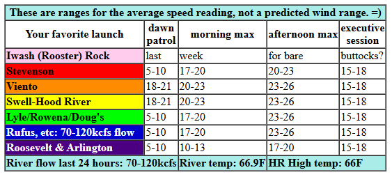
Wednesday started off with clouds to the west and pressures of 29.87/29.78/29.76 for gradients of 0.09/0.01. We have a cold front moving through. This leaves the west side chilly and cloudy and allows the east side to heat up. That’s despite the forecast of increasing clouds. Give the Gorge a couple hours to wake up. We’ll then see 20-23mph from Stevenson to Mosier this morning with a good shot at 23-26mph from Stevenson to The Dalles early afternoon. Rufus rises to 17-20mph by early afternoon and then rises to 23-26mph. Arlington: 16-19mph. This holds until late afternoon. For the Executive Session (after 5pm), westerlies drop to 15-18mph all through the Gorge (Stevenson to Rufus). River flow over the last 24 hours was 70-120kcfs, river temp is 66.9F, and high temp forecast is 66F for Hood River and 73F for Rufus.
RIVER FLOW FOR SITES BETWEEN AVERY (EAST OF THE DALLES) AND RUFUS: CLICK HERE FOR JOHN DAY DAM FLOW.
RIVER FLOW FOR SITES BETWEEN STEVENSON AND DOUG’S BEACH (WEST OF THE DALLES): CLICK HERE FOR THE DALLES DAM FLOW

tomorrow’s gorge wind forecast
A low pressure system settles offshore on Thursday and crushes the gradients. We’ll see early west wind at 7-10mph from Stevenson to Celilo with 18-22mph from Rufus to Arlington. The wind falls to 7-10mph everywhere midday and rises to 11-14mph from Stevenson to The Dalles in the afternoon. High temp: 66F in Hood River and 71F in the desert.
extended Gorge wind forecast
Friday has all sorts of things going against it! The low lingers offshore. Instability increases in the afternoon. A front is forecast to push through and bring rain in the evening. Best chance of wind is just ahead of that front when we sometimes see a quick blast of wind. Expect 10-13mph in the morning from Viento to Swell. That builds by a few mph early afternoon. If we get lucky, we’ll see a short burst of super-gusty 20-25mph just ahead of the front; this arrives first in Stevenson, shifts to Swell, and then shifts east to Doug’s… you get the picture. When rain arrives, the wind will die. High temp: 64F for Hood River and 70F at Rufus.
It’s possible we’ll see easterly Gorge westerlies in the mid 20s on Saturday and Sunday as rain plagues the west side and keeps the wind light there. But models have been bouncing around a lot and I don’t feel comfortable saying “it’s go time” for the weekend. I do feel comfortable saying that Saturday looks stronger than Sunday, and it also looks a few degrees warmer. With high temps falling below 60F this weekend, that’s definitely something to take into account. Has anyone seen my gloves? I think it’s gloves season! See you on the Nch’i Wana!
Was that helpful? I knew it was! Guess what? All of this crucial work – from your personal wind and snow reports to the invaluable TATAS updates – is made possible by my relentless efforts. Maintaining this labor of love isn’t easy. Each daily forecast takes hours. Website hosting, weather model access, and back-end admin work takes time and money. That’s where you come in.
YOUR CONTRIBUTION MAKES A DIFFERENCE
- SUPPORT ACCURATE, HYPER-LOCAL WEATHER FORECASTING
- ENABLE ACCESS FOR ALL, EVEN THOSE WITH LESS MEANS
- SUPPORT A COOL HUMAN WHO WORKS HARD SO YOU CAN PLAY
Take a moment to click one of the buttons below. Donate $19.99 or more (how much does this forecast enhance your life?) and get the email in your inbox. Whether it’s a renewing subscription (auto-renew) or a one-time donation, every contribution makes a real difference. Help me keep this labor of love alive, so we can all continue playing, commuting, and living in the Gorge with peace of mind and the best weather forecasts possible. Thank you!


Hood River, Oregon 97031


JONES BEACH, SAUVIE ISLAND, & COAST FORECAST
Wind northerly unless otherwise indicated. For coast, it’s North/Central/South with the “central” at approximately Florence. Swell forecast from NWS for central coast. Jones: westerly unless otherwise stated. Sauvie Island: northerly unless otherwise stated. Coast Wednesday: LTNW/LTNW/N10-15, NW swell 7′ at 9 seconds. Thursday: LTSE/LTS/S10-15, NW 6′ @ 11. Friday: LTW/LTSE/S15-20, W 2′ @ 16. Jones Wednesday: LTW. Thursday: LTV. Friday: W7-10. Sauvie Island Wednesday: 5-8. Thursday: LTV. Friday: variable to 10.
BARE BONES HOOD RIVER WEATHER FORECAST
Wednesday will be sunny early with increasing mid/high clouds. Temps start in the low 50s and rise to the mid 60s. Moderately strong westerlies. No rainbows. Thursday will be mostly cloudy with a little drizzle possible prior to sunrise. Temps start in the mid 40s and rise to the mid 60s. Light to moderate westerlies. 18% chance of rainbows. Friday will be cloudy during the day and rainy in the evening. Temps start in the upper 40s and rise to the mid 60s. Snow level 5500′. Light westerlies early, moderate later. 11% chance of rainbows.
TEMIRA’S AWESOME TRAVEL ADVISORY SERVICE
HYPERLOCAL WEATHER FORECAST FOR THE COLUMBIA GORGE
THE DALLES, HOOD RIVER, WHITE SALMON, TROUT LAKE, STEVENSON, CASCADE LOCKS, PARKDALE, ODELL, HUSUM, BZ, MILL A, WILLARD, GOLDENDALE, RUFUS, ARLINGTON, boardman
Good morning, neighbors! The Big, Beautiful Pattern Change arrives on Friday and plunges us into an abnormally chilly (it’s about time for some below-normal temps) few days. Sunday’s forecast: TWELVE degrees below normal! Rain starts up Friday night and continues through Monday night thanks to an offshore low spinning a series of systems our way.
Glenwood this morning
Even Glenwood should see rain. If it were raining there this morning, it would be freezing rain: Glenwood bottomed out (Glenwood’s a bottom, not a top, not a switch) at 30F this morning. Next chance of sub-freezing temps there (and other places) is on Sunday morning, when some areas of the Gorge will have clear sky.
Even more exciting weather will be seen on the higher mountain passes and hiking/biking trails: the snow level drops to 5500′ or less Friday night and stays there through Monday,d dropping as low as 3500′ at times. Sunday and Monday will be the days you’re most likely to see wintry driving conditions on the passes. Not down here, tho. No, not yet. But soon!
Today’s Gorge weather forecast
Back to today: low clouds in the west early with sun to the east. Mid and high clouds filter in late morning or early afternoon and stick around. This limits heating, especially on the west side where highs are forecast to be in the mid 60s. The Dalles: 71F. The Desert, where dessert is important every day to maintain the desert environment: 76F. West wind rises to 20-25mph from Stevenson to Mosier this morning and as far east as Rufus this afternoon. Overnight, increasing clouds finally give way to a little drizzle between Hood River and The Dalles after midnight. Maybe.
Thursday’s Gorge weather forecast
Clouds stick around Thursday thanks to a 1007mb, vertically stacked low pressure system offshore. A vertically stacked system is like a stack of pancakes, and like pancakes, this one looks delicious: it has the potential to send significant moisture this way. But not on Thursday. Nope. Thursdays starts chilly (45-50F) and ends pleasant (66-73F, coldest to the west). Wind will be relatively light thanks to that offshore low: 7-10mph all morning west of The Dalles with a brief period of 20mph wind east of The Dalles in the morning. Afternoon wind levels out at 10-15mph out of the west all through the Gorge.
Friday’s Gorge weather forecast
Friday will be cloudy then partly cloudy, then cloudy and wet in the evening and overnight. Morning temps, thanks to the clouds, will be relatively warm: 45-50F. Afternoon: mid 60’s to the west, upper 60s near The Dalles, and low 70s in the desert. West wind rises from 10mph in the morning near Hood River (less than 10mph everywhere else) to 20-25mph between Stevenson and Rufus ahead of incoming rain in the afternoon. Speaking of rain, it looks like we’ll see a round of it move in from the south late afternoon or early evening. That’s followed by a round of rain from the west overnight. I’m not going to hazard a guess yet on how much rain will fall, but it should be enough to tamp down the dust and soak those cover crops you’re planting today and tomorrow (hint, hint).
Extended Gorge weather forecast
Intermittent rain continues Saturday, Sunday, and Monday. High temps fall below 60F west of The Dalles and struggle to hit 60F in The Dalles. Out east, mid 60s Saturday, 60 Sunday, and upper 50s on Monday. Brrr! Especially brrr for the Emergency World Naked Bike Ride on Sunday at 2:30pm. Consider a clear plastic garbage bag (aka Meadows Performance Outerwear) as your “clothing”, and be prepared for the possiblity of hypothermia. As I mentioned earlier, the snow level over the weekend will fall below 5000′ and stay there. Will the mountains pick up enough snow above 4000′ for you to ski in it? It’s going to be close, and I sure have my eyes on it, despite the fact that warm ground temps will make the skiing not-good. But hey, maybe a snow-person and some snow angels are in our future, just a short drive away. Snow-persons are cool, but you know what’s cooler? Pumpkin persons. Safe travels. -TATAS
HEY! DON’T STOP READING! Is this community-focused forecast helpful to you? It sure is! It takes me a couple hours a day to write. Please join your friends and neighbors in contributing to keep it going. Venmo: @thegorgeismygym PayPal: twomirrors@gmail.com USPS: Temira / PO Box 841 / Hood River, Oregon 97031 You can test out the forecast subscription for a few days for free by signing up below. Easy! Do it!
MT HOOD SNOW FORECAST

CURRENTLY ON VACATION. WILL RETURN SOMETIME BEFORE THE START OF SKI SEASON AT MEADOWS, TIMBERLINE AND SKIBOWL. SAME GOES FOR THE NORDIC SKIING SEASON AT MEADOWS AND TEACUP!
