

GORGE WIND FORECAST
If you’re still seeing yesterday’s and it’s after 9am, try opening this in an incognito window
today’s gorge wind forecast
Hi friends! It’s a breezy Wednesday morning, and a windy day is on tap. Today and tomorrow look like the windiest of the next five. After that, the overall pattern shifts, leaving us cooler and lacking in support from the offshore waters. So get on these two big days if that’s your thing!
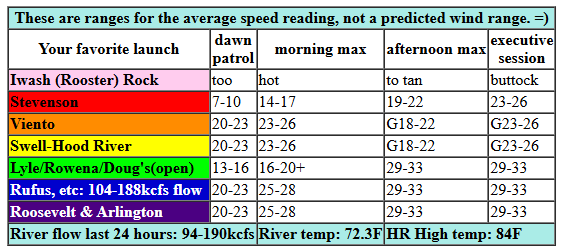
Wednesday started out with pressures of 29.95/29.82/29.76 for gradients of 0.13 (pdx-dls) and 0.08 (dls-psc). The metro area was clear. An approaching trough will reinforce cool air on the west side today. This screams, “NEAR EAST AND RUFUS,” but there should be plenty of fun on the west side too before the stabilizing cap breaks. Worth noting: models are over-forecasting the extent of the marine clouds, which means they may also be over-forecasting the wind speed. Dawn Patrol wind was 20-23mph from Viento to Swell with 7-10mph at Stevenson, 13-16 mph near Rowena, and 17-20mph from Rufus to Arlington. Westerlies pick up to 23-26mph from Viento to Swell and at Mosier pretty quickly with 19-22mph in Stevenson and Hood River. By late morning or early afternoon, we’ll have 29-33mph from Mosier to Arlington. The wind fills in to Boardman mid to late afternoon.
Taking a closer look at the Corridor (Viento to Hood River), models indicate the stabilizing cap breaking late morning. If that’s correct (and it probably is given the lack of clouds in the metro area), we’ll see the Corridor drop to gusty 19-22mph for a period of time. Models then bring the wind back late afternoon at 23-26mph for the Corridor. If all that was a little unclear, here’s the recap: Hatch area this morning. Lyle to Rufus late morning. Lyle to Boardman this afternoon and evening. River flow over the last 24 hours was 94-190kcfs (that’s going to be noticeable, especially for paddlers), river temp is 72.3F, and high temp forecast is 84F for Hood River, 92F for Rufus, and 98F at Boardman. Stay hydrated today.
RIVER FLOW FOR SITES BETWEEN AVERY (EAST OF THE DALLES) AND RUFUS: CLICK HERE FOR JOHN DAY DAM FLOW.
RIVER FLOW FOR SITES BETWEEN STEVENSON AND DOUG’S BEACH (WEST OF THE DALLES): CLICK HERE FOR THE DALLES DAM FLOW

tomorrow’s gorge wind forecast
A much deeper marine layer is in the cards for Thursday, and the desert is forecast to lose 10 degrees from Wednesday’s highs. This knocks down thermal support, but the clouds stabilize things. Expect 18-21mph near Swell to start with 20-23mph from Mosier to Arlington. Areas west of Mosier are a little tricky for the rest of the day as we wait to see what clouds will do. Best guess: up-and-down 18-21mph in the morning, gusty 20-25mph in the afternoon, and 17-20mph in the evening. From Mosier to Rufus, westerlies rise to 27-30mph+ by late morning or early afternoon and hold into the evening. Arlington: 23-26mph. There’s a bit of a chance of the wind over-performing thanks to the deep marine later. High temps: 77F for Hood River, 84F for Rufus.
extended Gorge wind forecast
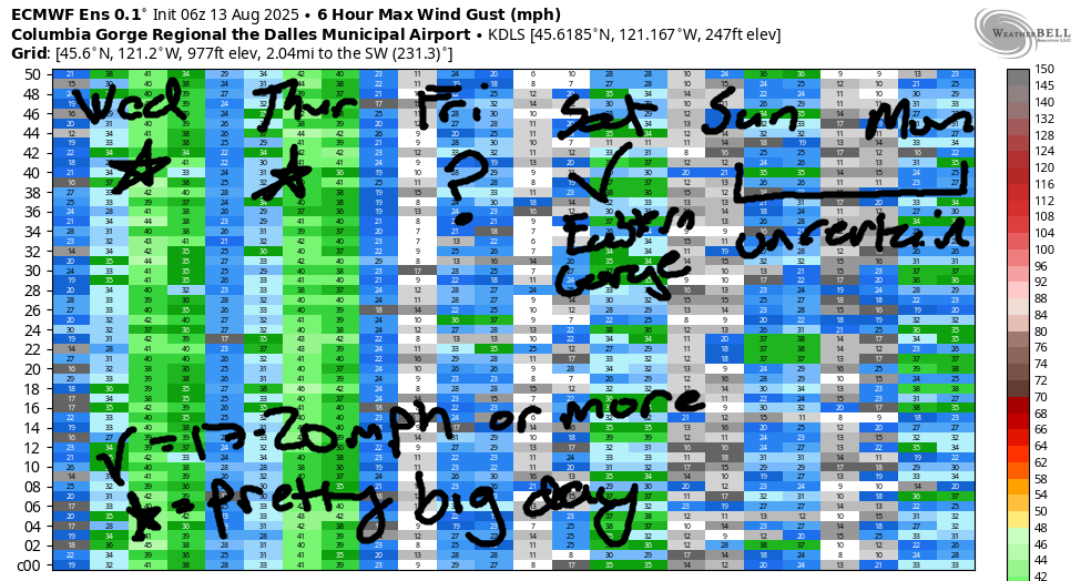
Friday looks… rainy! It also looks like the lightest wind day of the bunch. The day starts with light westerlies all through the Gorge. Deep clouds set up on the west side. Out east: partly cloudy. A lingering thermal gradient gives us 18-22mph in the afternoon east of The Dalles. High temp: 74F for Hod River and 83F for Rufus. Ensembles have a fair bit of range for the Saturday-Monday time frame. Wind will almost certainly be 17-20mph+ somewhere for Saturday and Sunday. Monday and beyond looks questionable. Let’s leave it there for now, shall we? Have a great day on the river today!
Was that helpful? I knew it was! Guess what? All of this crucial work – from your personal wind and snow reports to the invaluable TATAS updates – is made possible by my relentless efforts. Maintaining this labor of love isn’t easy. Each daily forecast takes hours. Website hosting, weather model access, and back-end admin work takes time and money. That’s where you come in.
YOUR CONTRIBUTION MAKES A DIFFERENCE
- SUPPORT ACCURATE, HYPER-LOCAL WEATHER FORECASTING
- ENABLE ACCESS FOR ALL, EVEN THOSE WITH LESS MEANS
- SUPPORT A COOL HUMAN WHO WORKS HARD SO YOU CAN PLAY
Take a moment to click one of the buttons below. Donate $19.99 or more (how much does this forecast enhance your life?) and get the email in your inbox. Whether it’s a renewing subscription (auto-renew) or a one-time donation, every contribution makes a real difference. Help me keep this labor of love alive, so we can all continue playing, commuting, and living in the Gorge with peace of mind and the best weather forecasts possible. Thank you!


Hood River, Oregon 97031


JONES BEACH, SAUVIE ISLAND, & COAST FORECAST
Wind northerly unless otherwise indicated. For coast, it’s North/Central/South with the “central” at approximately Florence. Swell forecast from NWS for central coast. Jones: westerly unless otherwise stated. Sauvie Island: northerly unless otherwise stated. Coast Wednesday: LTNW/LTNW/N25-30, NW swell 6′ at 9 seconds and SW 3′ @ 16. Thursday: SW15-20/LTV/N25, NW 4′ @ 9 and SW 2′ @ 15. Friday: SW20/SSW15-20/LTV, W 5′ @ 8 and SW 2′ @ 14. Jones Wednesday-Friday: LTW. Sauvie Island Wednesday: 14-17. Thursday: LTV. Friday: S 10.
BARE BONES HOOD RIVER WEATHER FORECAST
Clear sky all day Wednesday. Temps start in the mid 70s (record high-low!) and rise to the mid 80s. Strong westerlies. No rainbows. Thursday will be partly to mostly cloudy then clear. Temps start in the low 60s (thank the stars!) and rise to the upper 70s. Moderate to moderately strong westerlies. No rainbows. Friday will be drizzly in the morning, dry midday (and muggy) and rainy overnight. Temps start in the low 60s and rise to the mid 70s. Light westerlies. No rainbows.
TEMIRA’S AWESOME TRAVEL ADVISORY SERVICE
HYPERLOCAL WEATHER FORECAST FOR THE COLUMBIA GORGE
THE DALLES, HOOD RIVER, WHITE SALMON, TROUT LAKE, STEVENSON, CASCADE LOCKS, PARKDALE, ODELL, HUSUM, BZ, MILL A, WILLARD, GOLDENDALE, RUFUS, ARLINGTON, boardman
Good morning, neighbors! Who’s ready for an exciting stretch of weather?!?! Meeeeeeeeeeee! We have a super windy (and way cooler) day today. We also have extreme fire danger. Please be careful out there. Today’s followed by another breezy and partly cloudy and cool day on Thursday. On Friday, we get rain, glorious rain, so much rain that I want to use an expletive! It’s going to fucking rain! After that: cool weather all the way through the latter part of next week as low pressure (mostly) hangs offshore and a trough of cool air lingers over the PNW. This will make you want to linger outside. You should. Lots of research supports the link between Nature and good mental health.
this morning in the gorge and glenwood
This morning started with a lot of really warm temps and a record high-low for Hood River. Previous record was 66F set in 1981. At 6am, it was 73 degrees at HOXO. If you think that’s impressive, check this out: the NWS sensors in Rowena and Mosier both had overnight lows of 80 degrees! Note: one very clear and consistent trend linked to climate change is warming morning temps. Naturally I’ve managed to misplace my link for that trend graph (and don’t want to look this morning), but I’ll find it again someday! Glenwood, however, was not hot this morning. As a matter of fact, it was quite cool: 51 degrees. I’m still considering a summer home there…
today’s gorge weather forecast
For the rest of us today… looks like NWS Portland and Pendleton got together on the forecasts today: we have a Red Flag warning for both sides of the Nch’i Wana (Big River, aka Columbia River) from Viento east to the watermelon-growing zones and the Big Rodeo Zone (Pendleton). Temps today rise to the mid 80s (west), low 90s (The Dalles), and upper 90s (Rodeo Zone). That’s down nearly 15 degrees over yesterday for the west side, and will be oh-so-welcome! West wind starts at 15-20mph from Stevenson to Mosier. By late morning or early afternoon, westerlies rise to 25-30mph from Stevenson to Hood River with 30-35mph from Mosier to Boardman. BE. VERY. CAREFUL. WITH. SPARKS. Do not start a fire. Both the Rowena and Burdoin fires started on similar weather days. Give yourself a break today from mowing and weed-whacking and chainsawing.
thursday’s gorge weather forecast
Overnight tonight, a trough drops down from BC. Thanks, Canada! While it won’t be bringing Cheezies or Coffee Crisp candy bars (sad), it will bring much cooler air. Overnight temps will be down into the 60s or less. Hell yes! We’ll start Thursday with lots of clouds west of Mosier and clear sky to the east. A few high clouds drift in later, a sign of this incoming cooler system. Temps max out in the upper 70s (west), low 80s (The Dalles) and upper 80s (The Desert). I wouldn’t be surprised if the west side can’t achieve the upper 70s. West wind will be 15-20mph from Viento to Mosier early with 20-25mph east of Mosier to Arlington. Afternoon wind rises to 20-25mph west of Mosier and 25-30mph from Mosier to Rufus with 20-25mph near Arlington.
extended Gorge weather forecast
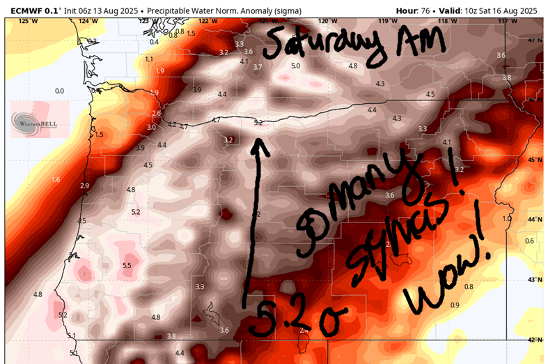
Things get wet on Friday. Models are still all over the place on rain totals: 0.05” to 0.45” for The Dalles and 0.6” to 1.1” for Cascade Locks. Models also take at least some rain all the way east to the Arlington Triangle! Models are in complete agreement on the massive amount of available moisture: dewpoint 60+ degrees, PWAT 4” sigmas (5.2 at one point in time!!!), and
PWAT 1.7”. HOLY MOISTNESS, BATMAN! As for the rain deets, it looks like drizzle Friday morning and rain (POURING west of Wyeth) overnight Friday with drizzle into early Saturday morning. I. CAN’T. WAIT!
Saturday looks cool and muggy. Coolish (under 85 degree for The Dalles) weather persists for a few days. As a matter of fact, coolish weather persists until at least next Thursday. Yay. Safe travels. -TATAS
HEY! DON’T STOP READING! Is this community-focused forecast helpful to you? It sure is! It takes me a couple hours a day to write. Please join your friends and neighbors in contributing to keep it going. Venmo: @thegorgeismygym PayPal: twomirrors@gmail.com USPS: Temira / PO Box 841 / Hood River, Oregon 97031 You can test out the forecast subscription for a few days for free by signing up below. Easy! Do it!
