

GORGE WIND FORECAST
If you’re still seeing yesterday’s and it’s after 9am, try opening this in an incognito window
today’s gorge wind forecast
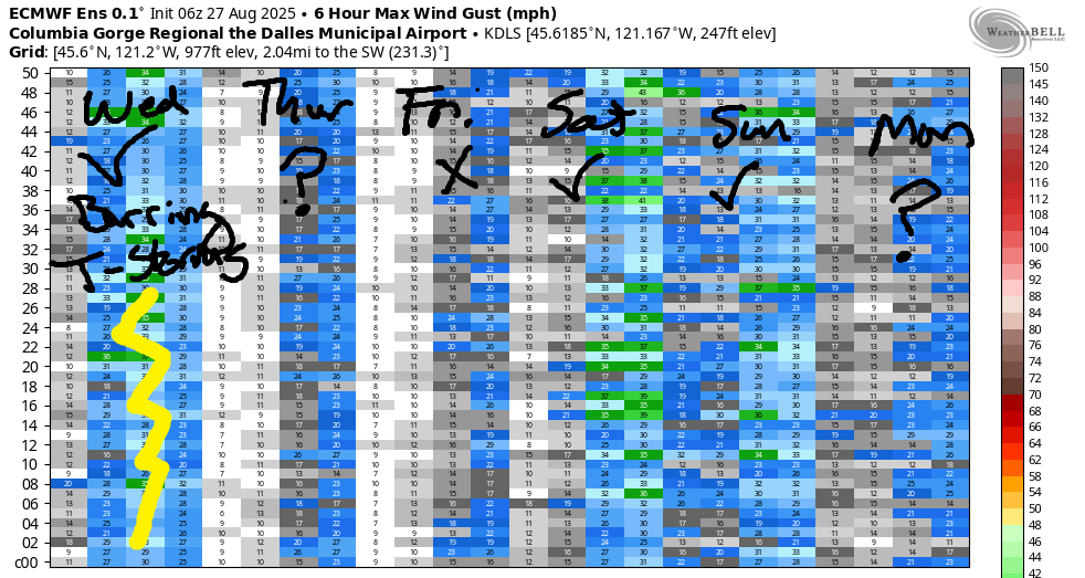
Hi friends! Complicated weather picture today (Wednesday) makes for a complicated and low-reliability Gorge wind forecast. Building riding over the next couple days knocks the wind down. For the weekend, it looks like a low moving inland will give us solid westerlies on Saturday and somewhat lesser westerlies Sunday, but there are a lot of details needing clarification between now and then. Looking at Labor Day (#UnionStrong, #UnionProud), we see the start of a warming trend and (probably) lesser westerlies, but there’s still a fair bit of uncertainty that far in the future.
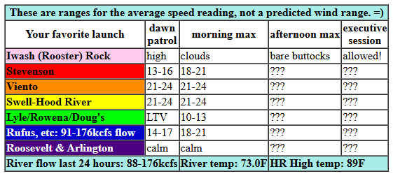
Taking a look at the daybreak pressures, we have 29.92/29.82/29.82 for 0.10 (PDX-DLS). On a “normal” day, that would be enough to drive westerlies in the low 20s near the Hatch. This is not a normal day as you can see by the extensive cloud cover. A couple weather features moving through today drive thunderstorm potential early this morning and also this afternoon, and that makes the wind tricky to predict. If all goes as well as possible, we’ll see morning westerlies at 21-24mph (maybe a touch more) from Viento to Mosier. Stevenson, the Rowena zone, and Avery join in late morning. Rufus may briefly hit the 18-21mph range before dropping to 14-17mph late morning. Don’t chase the eastern Gorge today! Now, let’s talk about the afternoon: models suggest that this incoming weather feature will trigger significant instability. This will (likely) shut down the wind, or at least knock it way down. Add in the possibility for lightning. River flow over the last 24 hours was 88-176kcfs, river temp is 73.0F, and high temp forecast is 89F.
RIVER FLOW FOR SITES BETWEEN AVERY (EAST OF THE DALLES) AND RUFUS: CLICK HERE FOR JOHN DAY DAM FLOW.
RIVER FLOW FOR SITES BETWEEN STEVENSON AND DOUG’S BEACH (WEST OF THE DALLES): CLICK HERE FOR THE DALLES DAM FLOW

tomorrow’s gorge wind forecast
Moving on to Thursday… our best hope is afternoon thermals as central Oregon heats up. The day starts with 11-14 form Viento to the Hatch and then quickly drops below 10mph. Afternoon wind, if we’re lucky, will rise to 11-14mph from Stevenson to Hood River and 15-18mph from Mosier to Doug’s. High temp: 92F.
extended Gorge wind forecast
Weak high pressure builds inland on Friday. With heat on the west side and heat on the east side, we won’t have much wind. Early morning brings 11-14 from Viento to the Hatch. A little more wind is possible middle, perhaps 13-16mph from Viento to the Hatch, but even that is low-probability. Afternoon wind rises to 14-17mph from Stevenson to Rufus. High temp: 94F.
Looking at the weekend, we have complicated weather dynamics and a fair bit of uncertainty about the details of these dynamics. Generally speaking, a cool low will be offshore, and the desert will be hot. Thermal gradients look strong in the afternoon, which could give us 26-29mph from Stevenson to Rufus. That said, the offshore low is likely to turn flow southerly and drag in moisture; that combo could fire off instability and/or thunderstorms. Uncertainty is captured well by the Euro ensembles: lots of range in the possible outcomes. All that said, we should see enough wind to get many of you on the water on Saturday. On Sunday, the focus (probably) shifts to the Near East (Rowena area) and Eastern Gorge (Rufus and beyond). Best guess given the setup is moderately strong, quite gusty conditions that focus on the Rowena area with Rufus as next-best.
Ensembles then suggest a warming trend starting Labor Day. That said, there’s quite a big of uncertainty in how how it will get. Generally speaking, the wind looks light to borderline (westerly) through the middle part of next week. I’ll be on retreat Friday through the following Thursday. I swear the most likely outcome is that it will be nuking every day I’m gone, but that doesn’t always work out. See you on the Nch’i Wana!
Was that helpful? I knew it was! Guess what? All of this crucial work – from your personal wind and snow reports to the invaluable TATAS updates – is made possible by my relentless efforts. Maintaining this labor of love isn’t easy. Each daily forecast takes hours. Website hosting, weather model access, and back-end admin work takes time and money. That’s where you come in.
YOUR CONTRIBUTION MAKES A DIFFERENCE
- SUPPORT ACCURATE, HYPER-LOCAL WEATHER FORECASTING
- ENABLE ACCESS FOR ALL, EVEN THOSE WITH LESS MEANS
- SUPPORT A COOL HUMAN WHO WORKS HARD SO YOU CAN PLAY
Take a moment to click one of the buttons below. Donate $19.99 or more (how much does this forecast enhance your life?) and get the email in your inbox. Whether it’s a renewing subscription (auto-renew) or a one-time donation, every contribution makes a real difference. Help me keep this labor of love alive, so we can all continue playing, commuting, and living in the Gorge with peace of mind and the best weather forecasts possible. Thank you!


Hood River, Oregon 97031


JONES BEACH, SAUVIE ISLAND, & COAST FORECAST
Wind northerly unless otherwise indicated. For coast, it’s North/Central/South with the “central” at approximately Florence. Swell forecast from NWS for central coast. Jones: westerly unless otherwise stated. Sauvie Island: northerly unless otherwise stated. Coast Wednesday: LTNW/LTNW/LTV, NW swell 4′ at 7 seconds. Thursday: LTW/LTW/LTV, NW 2′ @ 7. Friday: LTW/LTW/LTV, NW 2′ @ 7. Jones Wednesday: 15-18. Thursday: 11-14. Friday: 19-22. Sauvie Island Wednesday: LTN. Thursday: 8-11 > 5pm. Friday: LTV.
BARE BONES HOOD RIVER WEATHER FORECAST
Clouds this morning with a chance of thunder, partly cloudy midday, chance of thunder again later. Temps start in the mid 70s (record high-low) and rise to the upper 80s (maybe). Moderate to moderately strong westerlies. 5% chance of rainbows. Thursday will be partly Nothing (maybe!) and then clear. Temps start in the low 60s (thank the stars) and rise to the low 90s (too hot). Light westerlies becoming moderate late. No rainbows. Friday will be sunny in the morning with a few mid-level clouds in the afternoon. Temps start near 60 and rise to the mid 90s. Light to moderate westerlies. No rainbows.
TEMIRA’S AWESOME TRAVEL ADVISORY SERVICE
HYPERLOCAL WEATHER FORECAST FOR THE COLUMBIA GORGE
THE DALLES, HOOD RIVER, WHITE SALMON, TROUT LAKE, STEVENSON, CASCADE LOCKS, PARKDALE, ODELL, HUSUM, BZ, MILL A, WILLARD, GOLDENDALE, RUFUS, ARLINGTON, boardman

Good morning, neighbors! Interesting weather on tap today as abundant available moisture, southerly flow, and an incoming disturbance combine for a shot at thunderstorms. Some of us (me, and the inside of my car too since my windows were open) picked up a trace of rain early this morning. If we get lucky, we could get more later! After today, things settle down (and warm up) for a couple days. Over the weekend, another round of exciting weather is possible. I shall be on retreat, so you shall have to enjoy it without me. Incidentally, I have a housesitter staying at my place. Please do not bother her for weather information. She does not specialize in that.
Looking at Wednesday morning… it’s a hot one. Glenwood started the day at 68 degrees. I wish I knew Glenwood’s all-time record high-low, because I’d bet that’s close to it. Why so hot this morning? High humidity, west wind, and most of all, cloud cover. Models hint at some clearing midday before another round of thunderheads this afternoon. Wind today will climb to west 20-25mph between Stevenson and Avery with 15mph near Rufus.
Humidity lingers overnight and sets us up for another 60+ degree morning on Thursday. With mostly clear sky, the day will turn hot: low 90s to the west, mid 90s to the east. West wind will be 10-15mph west of Hood River early, less thank 10mph everywhere midday, and 15-20mph from Mosier to Murdoch in the afternoon.
Lower humidity Friday morning should set us up for a somewhat cooler start. THANK THE STARS! Riding overhead makes for a hot finish: mid to upper 90s. West wind will be 10mph between Viento and Hood River in the morning and 15mph between Stevenson and Rufus in the afternoon. Looking to the weekend… I’ll be meditating, yay. You’ll be here doing your thing. The weather will be turning active: thanks to an offshore low, the Gorge will once again be under southerly flow with increasing humidity. If y’all get lucky, you’ll get thunderstorms, hopefully with lots of rain. Looking beyond the weekend, we see another round of potentially hot weather. I don’t know about y’all, but I’m ready for and extended stretch of cooler temps! Safe travels. -TATAS
HEY! DON’T STOP READING! Is this community-focused forecast helpful to you? It sure is! It takes me a couple hours a day to write. Please join your friends and neighbors in contributing to keep it going. Venmo: @thegorgeismygym PayPal: twomirrors@gmail.com USPS: Temira / PO Box 841 / Hood River, Oregon 97031 You can test out the forecast subscription for a few days for free by signing up below. Easy! Do it!
MT HOOD SNOW FORECAST

CURRENTLY ON VACATION. WILL RETURN SOMETIME BEFORE THE START OF SKI SEASON AT MEADOWS, TIMBERLINE AND SKIBOWL. SAME GOES FOR THE NORDIC SKIING SEASON AT MEADOWS AND TEACUP!
