

GORGE WIND FORECAST
If you’re still seeing yesterday’s and it’s after 9am, try opening this in an incognito window
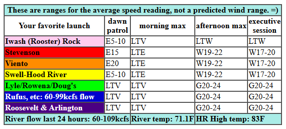
today’s gorge wind forecast
Hi friends! I’m looking out my window right now and seeing LOTS of boats fishing at the mouth of the White Salmon. Clearly it’s not windy. As a matter of fact, models and reality are not in agreement – reality has east wind right now, and models have west wind, or at best, nothing at all. Things will change for the better later today, and we’ll stick with westerlies of some sort for a few days. Not a bad Gorge wind forecast for September, eh?
Looking at this morning, gradients where lightly offshore to start. The heat low shifts inland today and turns gradients onshore, but it will take a bit. By late morning, westerlies rise to 17-20mph from Stevenson to the Hatch with 11-14mph from Hood River to Mosier, Desert heating this afternoon and a weak front moving inland will nudge the wind up this afternoon. We’ll have gusty 19-23mph from Stevenson to Mosier with 13-16mph near Rowena mid-afternoon. Later in the day, we’ll have gusty 17-20mph from Stevenson to Hood River, and gusty 20-24mph from Mosier to Avery. In the evening, the wind spreads to Arlington and potentially rises to gusty 22-25mph between Avery and Arlington. River flow over the last 24 hours was 60-109kcfs, river temp is 71.1F, and high temp forecast is 83F for Hood River and 88F for Rufus.
RIVER FLOW FOR SITES BETWEEN AVERY (EAST OF THE DALLES) AND RUFUS: CLICK HERE FOR JOHN DAY DAM FLOW.
RIVER FLOW FOR SITES BETWEEN STEVENSON AND DOUG’S BEACH (WEST OF THE DALLES): CLICK HERE FOR THE DALLES DAM FLOW

tomorrow’s gorge wind forecast
On Thursday, the front exits the region. Low clouds start the day on the west side. Models are rather unimpressed by this for whatever reason. The day starts with 19-22mph from Viento to the hatch with 13-16mph between Hood River and Rowena. Expect the same through mid-afternoon, when the wind dips to 17-20mph but spreads out from Stevenson to Rufus. High temp: 78F in Hood River.
extended Gorge wind forecast
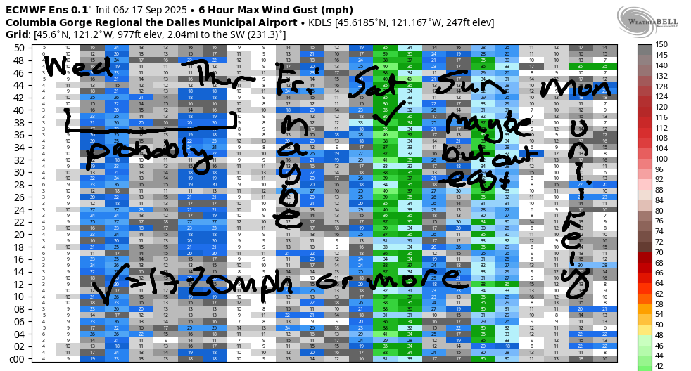
A ridge builds inland on Friday. After a few morning clouds, the sky clears. We’ll see 17-20mph from Viento to the Hatch early, 14-17mph midday, and 16-19mph from Stevenson to Rufus in the afternoon. A better chance of stronger wind exists on Saturday. Cool air settles in over the west side as a trough approaches. Out in the desert: still warm. This temp gradient gives us 24-27mph or more out east. I’m hedging my bets a little right now, but “or more” wouldn’t surprise me one bit. Sunday: rain to the west, sun out east, and 20-something mph in the desert. Models are pretty insistent on a light/variable day for Monday. That’s enough for now. See you on the Nch’i Wana!
Was that helpful? I knew it was! Guess what? All of this crucial work – from your personal wind and snow reports to the invaluable TATAS updates – is made possible by my relentless efforts. Maintaining this labor of love isn’t easy. Each daily forecast takes hours. Website hosting, weather model access, and back-end admin work takes time and money. That’s where you come in.
YOUR CONTRIBUTION MAKES A DIFFERENCE
- SUPPORT ACCURATE, HYPER-LOCAL WEATHER FORECASTING
- ENABLE ACCESS FOR ALL, EVEN THOSE WITH LESS MEANS
- SUPPORT A COOL HUMAN WHO WORKS HARD SO YOU CAN PLAY
Take a moment to click one of the buttons below. Donate $19.99 or more (how much does this forecast enhance your life?) and get the email in your inbox. Whether it’s a renewing subscription (auto-renew) or a one-time donation, every contribution makes a real difference. Help me keep this labor of love alive, so we can all continue playing, commuting, and living in the Gorge with peace of mind and the best weather forecasts possible. Thank you!


Hood River, Oregon 97031


JONES BEACH, SAUVIE ISLAND, & COAST FORECAST
Wind northerly unless otherwise indicated. For coast, it’s North/Central/South with the “central” at approximately Florence. Swell forecast from NWS for central coast. Jones: westerly unless otherwise stated. Sauvie Island: northerly unless otherwise stated. Coast Wednesday: 15-20/20-25/30+, W swell 5′ at 11 seconds. Thursday: 20-25/25/35, NW 9′ @ 11. Friday: 10-15/15/25, NW 6′ @ 10. Jones Wednesday: 1518. Thursday: 12-15. Friday: 14-17. Sauvie Island Wednesday: 11-14. Thursday: 13-16. Friday: LTN.
BARE BONES HOOD RIVER WEATHER FORECAST
Clear sky today with just a few high clouds later. Temps start in the low 50s (NORMAL!) and rise to the low 80s. Moderate westerlies. No rainbows. Thursday will have some low clouds to start, and it’ll finish partly high overcast. Temps start in the mid 50s and rise to the upper 70s. Moderate westerlies. No rainbows. Friday will be mostly clear. Temps start in the low 50s and rise to the mid 80s. Moderate westerlies. No rainbows.
TEMIRA’S AWESOME TRAVEL ADVISORY SERVICE – WEDNESDAY
HYPERLOCAL WEATHER FORECAST FOR THE COLUMBIA GORGE
THE DALLES, HOOD RIVER, WHITE SALMON, TROUT LAKE, STEVENSON, CASCADE LOCKS, PARKDALE, ODELL, HUSUM, BZ, MILL A, WILLARD, GOLDENDALE, RUFUS, ARLINGTON, boardman
Good morning, neighbors. It’s fall, for sure! I swear, despite the calendar, that it’s fall. Soon ends the season of repetitive weather and brings the season of chaos. With La Nina likely this winter, we’re likely to have a cool and wet one… DON’T PANIC! Just because La Nina is cool and wet doesn’t mean we’ll get lots of snow and ice. I just got curious about 2016-2017. The NOAA historical ENSO data says that was initially a weak La Nina, and then it transitioned to neutral.
Glenwood this morning
But right now, this morning, we have a brilliantly clear start to the day. Glenwood’s balls are freezing off because it’s 40 degrees there. Glenwood still has balls because if we cut the balls off all the small towns, they will stop making small towns. And small towns, with their deep sense of community, are the best.
Today’s Gorge weather forecast
For the rest of us today: a cool start and a warm finish: 83F (west) to 88F (The Dalles) and 86F (desert). A light wind start gives way to 20mph from Stevenson to Mosier this morning and from Stevenson to Murdoch or maybe Avery this afternoon. The wind spreads east to the Arlington Equilateral Triangle in the evening after making a stop in Biggs for Indian food and a full tank of gas. The wind drives a 20 year-old gas-powered car, but is planning to switch to an EV in the next couple of weeks before the subsidies expire.
Thursday’s Gorge weather forecast
Tomorrow, Thursday looks a lot like today: mostly sunny, highs from 78F (west) to 85F (east), and west wind at 15-20mph all day, strongest near Hood River in the morning and spreading east to Rufus in the afternoon. High pressure builds inland on Friday for a somewhat warmer (84F to 89F) day. West wind will be 15-20mph in the morning near Hood River and 15-20mph in the afternoon between Stevenson and Rufus.
Extended Gorge weather forecast
Moving on to Saturday… we have an approaching weather system that doesn’t do much Saturday other than lower temps a few degrees and nudge the wind upward and eastward. Fishing plans Saturday? Get it early: afternoon wind rises to 20-25mph west of Avery and 25-30mph from Avery east to Boardman.
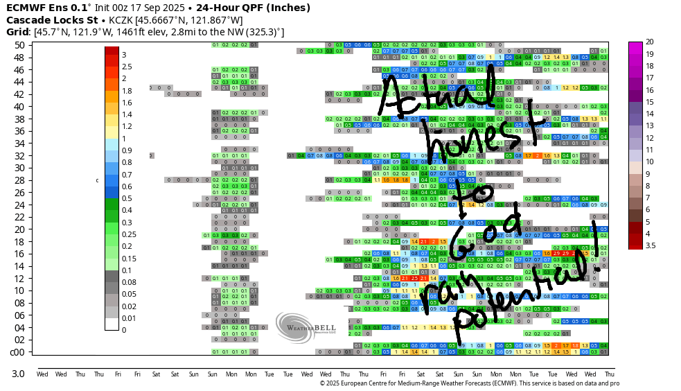
Rain is possible Sunday west of Mosier, but models have (naturally) been trending downward on rain amounts. SO ANNOYING. I WANT THE END OF FIRE SEASON! As we look deeper into September, we still see pretty good ensemble agreement (ECMWF) about a pattern change towards the end of the month. This pattern change is not from calico to damask. Nor is it from paisley to plaid. It’s from warm and sunny to cool and wet. Apparently Meadows already saw termination dust, so this upcoming (PLEASE) cooler, wetter period will merely be round two of early high-elevation snowfall. Which will be nice, because our mountains look very naked right now and nobody likes a naked volcano. Safe travels. -TATAS
HEY! DON’T STOP READING! Is this community-focused forecast helpful to you? It sure is! It takes me a couple hours a day to write. Please join your friends and neighbors in contributing to keep it going. Venmo: @thegorgeismygym PayPal: twomirrors@gmail.com USPS: Temira / PO Box 841 / Hood River, Oregon 97031 You can test out the forecast subscription for a few days for free by signing up below. Easy! Do it!
MT HOOD SNOW FORECAST

CURRENTLY ON VACATION. WILL RETURN SOMETIME BEFORE THE START OF SKI SEASON AT MEADOWS, TIMBERLINE AND SKIBOWL. SAME GOES FOR THE NORDIC SKIING SEASON AT MEADOWS AND TEACUP!
