

GORGE WIND FORECAST
today’s gorge wind forecast
Hi friends! Looks like a solid day on the river today, and the Gorge wind forecast looks good through Friday. With a heat wave forecast to settle in for the weekend, the wind looks lighter Saturday and Sunday. Models hint at it returning late on Monday, but cooling is often delayed. By Tuesday, however, we should (probably) be back in west wind for a while, although it’s unclear how strong that wind will be.
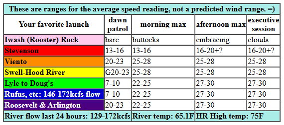
Wednesday started off with clouds piled up against the Cascades. Pressures at 6am were 30.06/29.95/29.90 for gradients of 0.11 (PDX-DLS) and 0.05 (DLS-PSC). Clouds are forecast to stick around on the west side for a good portion of the day, long enough to give the desert a jump on the heating. A front offshore could disrupt the wind some, but it’ll be counteracted by the stabilizing effect of low clouds. So… expect early wind at 20-23 from Viento to Mosier with 10-13mph west of Viento and east of Mosier. By late morning, we’ll have 25-28 from Viento to Avery with 22-25 from Celilo to Arlington. Stevenson will lag behind today as clouds will be slow to burn off. Call it gusty 13-16 this morning. Afternoon wind rises to 27-30 from Mosier to Arlington with 25-28 from Viento to Hood River. Stevenson’s wind depends on what the clouds do – if they burn off enough, it’ll manage gusty low 20s. If they don’t: mid teens. River flow over the last 24 hours was 129-172kcfs (146-172kcfs at Rufus), river temp is 65.1F, and high temp forecast is 75F for Hood River and 82F for Arlington.
RIVER FLOW FOR SITES BETWEEN AVERY (EAST OF THE DALLES) AND RUFUS: CLICK HERE FOR JOHN DAY DAM FLOW.
RIVER FLOW FOR SITES BETWEEN STEVENSON AND DOUG’S BEACH (WEST OF THE DALLES): CLICK HERE FOR THE DALLES DAM FLOW

tomorrow’s gorge wind forecast
A weak weather system moves inland on Thursday and keeps the west side cloudy. Models suggest clouds will push past Hood River in the morning, which shifts the strongest wind to the east. Early wind will be 10mph or so from Stevenson to Doug’s with 19-22 from Avery to Threemile. By late morning or early afternoon, westerlies rise to up-and-down, gusty 20-24 from Viento to Doug’s (more is likely at Viento). Between Avery and Boardman, expect 27-30mph. It’s possible the Lyle-Doug’s stretch could join in at those higher speeds – it really depends on how far east those low clouds extend. Stevenson, per the sounding model, will be cloudy all day. That’s likely to result in the wind staying under 15mph there all day. High temp: 72F in Hood River and 77F in Arlington.
extended Gorge wind forecast
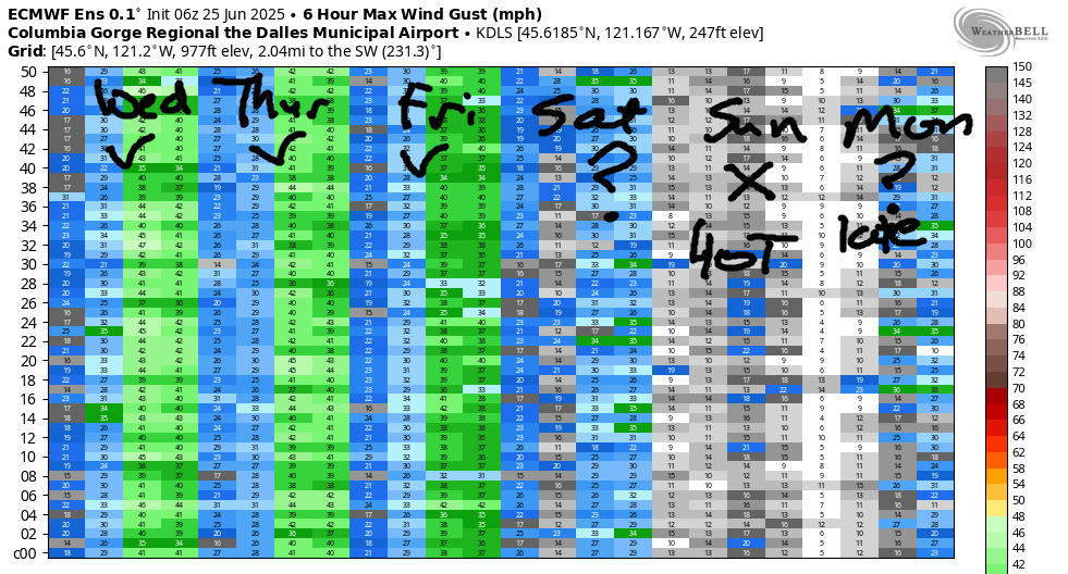
Cooler air finally makes its way into the desert on Friday. This results in a lesser thermal gradient and a decrease in wind speeds. Per the GFS deterministic, the day starts with 5-10mph from Stevenson to Doug’s with 11-14mph from Avery to Arlington. Midday wind rises to 19-22 from Stevenson to Doug’s with 14-17 at Avery. Afternoon: gusty 16-19 at Swell, 20-23 from Mosier to Avery, and 14-17 at Rufus. It’s worth noting that the ensembles suggest stronger wind than that, so don’t be surprised if the forecast changes. After writing all that and taking into account a forecast of partly cloudy sky for the metro area all day, I too think the wind will be stronger. Let’s go with 22-25mph instead.
A heat wave is forecast for the weekend. Models suggest onshore (west) wind will persist for Saturday, but the strength is unclear. The location is clear: Stevenson to Mosier will be the focus. For now let’s call it 17-20mph at the Hatch. With 90 degree temps extending from the metro area to the desert on Sunday, we’re likely to have a no-wind day. Models for Monday are all over the place – it’s possible we could see west-side cooling in the evening combined with very hot temps in the desert. If this plays out just right, we’ll have strong westerlies late Monday. Most of the time, this pattern results in delayed cooling and overnight wind. Maybe we’ll get lucky this time and the cooling will arrive early as forecast! Generally speaking, next week looks windy, but there’s about 10 degrees spread in the forecast highs; there’s also quite a bit of range in wind speeds forecast by the ensembles. Vote for the cooler high temps, especially on the west side, as that’ll result in stronger, steadier wind. Let’s leave it here for today. Have a great day on the river!
Was that helpful? I knew it was! Guess what? All of this crucial work – from your personal wind and snow reports to the invaluable TATAS updates – is made possible by my relentless efforts. Maintaining this labor of love isn’t easy. Each daily forecast takes hours. Website hosting, weather model access, and back-end admin work takes time and money. That’s where you come in.
YOUR CONTRIBUTION MAKES A DIFFERENCE
- SUPPORT ACCURATE, HYPER-LOCAL WEATHER FORECASTING
- ENABLE ACCESS FOR ALL, EVEN THOSE WITH LESS MEANS
- SUPPORT A COOL HUMAN WHO WORKS HARD SO YOU CAN PLAY
Take a moment to click one of the buttons below. Donate $19.99 or more (how much does this forecast enhance your life?) and get the email in your inbox. Whether it’s a renewing subscription (auto-renew) or a one-time donation, every contribution makes a real difference. Help me keep this labor of love alive, so we can all continue playing, commuting, and living in the Gorge with peace of mind and the best weather forecasts possible. Thank you!


Hood River, Oregon 97031


JONES BEACH, SAUVIE ISLAND, & COAST FORECAST
Wind northerly unless otherwise indicated. For coast, it’s North/Central/South with the “central” at approximately Florence. Swell forecast from NWS for central coast. Jones: westerly unless otherwise stated. Sauvie Island: northerly unless otherwise stated. Wednesday: LTW/LTW/N10-15, W swell 4′ at 11 seconds. Thursday: LTW/LTW/N15-20, W 3′ @ 10. Friday: LTNW/N10-15/N20-25, W 4′ @ 8. Jones Wednesday: LTW. Thursday: LTW. Friday: 5-10. Sauvie Island Wednesday: 10-13 > 5pm. Thursday: 16-19. Friday: 10-13.
BARE BONES HOOD RIVER WEATHER FORECAST
Mostly clear sky this morning adds high clouds later. Temps start in the low 60s and rise to the mid 70s. Strong westerlies. No rainbows. Thursday will be cloudy then partly cloudy. Temps start in the mid 50s and rise to the low 70s. Light westerlies early. Moderate later. No rainbows. Friday will be partly cloudy. Temps start in the mid 50s and rise to the mid 70s. Light westerlies early. Moderate later. No rainbows.
TEMIRA’S AWESOME TRAVEL ADVISORY SERVICE
HYPERLOCAL WEATHER FORECAST FOR THE COLUMBIA GORGE
THE DALLES, HOOD RIVER, WHITE SALMON, TROUT LAKE, STEVENSON, CASCADE LOCKS, PARKDALE, ODELL, HUSUM, BZ, MILL A, WILLARD, GOLDENDALE, RUFUS, ARLINGTON, boardman
Good morning, neighbors! Looks like we’re lining up for a bit of a heat wave late this week along with our first 100 degree day come next Monday. So enjoy the pleasant, TATAS-approved weather between now and then. It sure does look pleasant for the next few days – cool temps, a cooling breeze, and even some cool clouds for the west side.
glenwood this morning
Let’s check in with Glenwood before we get too deep in the weeds of the forecast. It was 60 degrees there this morning. Wow. That’s warm. Everyone in Glenwood was very confused this morning. They each were convinced that they’d been transported to a different tropical location. Bob was sure he was smoking his morning cigar on a porch in Tahiti, and Sue thought she was on Maui. Carol insisted to her wife Mabel that they’d been transported to Reunion Island overnight, and Mabel was certain they were on Ibiza. But that’s probably because she has audio hallucinations of electronic dance music (EDM). Names and situations described in this paragraph are works of fiction and are in no way modeled after any real human beings.
today’s (Wednesday) Gorge weather forecast
After a 60 degree start in Glenwood and most other Gorge locations, we’ll see a completely reasonable warm-up: 75 degrees on the west side, 80 degrees in The Dalles, and 90 degrees out where the watermelons are sucking up water and expanding their waistlines. You too should stay hydrated today despite the lack of intense heat. Water is good for you – you are 45-75% H2O. West wind will be 20-30mph pretty much everywhere along the river between Stevenson and the Arlington Triangle today. West of Hood River, morning low clouds give way to partly cloudy sky. To the east, clear sky in the morning adds high clouds in the afternoon. TATAS gives this day five stars. Out of five, not out of 100. Rating scales are important.
thursday’s gorge weather forecast
Wednesday’s persistent low clouds in the west are caused by a weak weather system. This repeats on Thursday – low clouds stick around, to some extent, all day long west of Hood River. Areas west of Cascade Locks could see a little mist – not enough moisture for actual rain – between dawn and early afternoon. Temps start in the mid 50s. Afternoon temps rise to the low 70s (west), mid-upper 70s (The Dalles) and mid 80s (watermelons). Wind will be 5-10mph west of The Dalles early with 15-20mph between The Dalles and Boardman. Afternoon wind rises to 20-25mph between Stevenson and The Dalles and 25-30mph from Avery to Boardman.
extended gorge weather forecast
On Friday, we’ll have similar temps to Thursday and somewhat less wind. The wind might be light enough to spray early in the morning. Afternoon wind rises to 15-25mph between Stevenson and The Dalles with 15mph near Biggs. Partly cloudy sky sticks around west of Hood River all day with a few high clouds thrown in the mix for all of us.
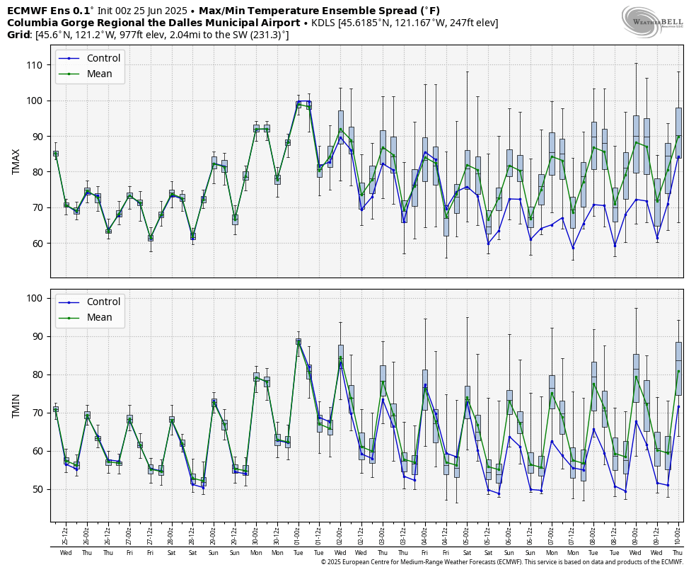
Temps start to warm up on Saturday: 80-85 degrees. Sunday: 90-93 degrees. Monday: 98-100 degrees. With the heat comes less wind. Beyond Monday, there’s quite a bit of uncertainty in the models. Forecast high temps have a 10 degree spread (or more) each day. “Cool” is not part of the picture – the minimum of the temp range on any give day never drops below 75 degrees, and the minimum is around 80 degrees most days. In other words, the weather looks warm next week. That’s good news for your tomato and pepper and watermelon plants and bad news for your armpits and groin and underboobs. Safe travels. -TATAS
HEY! DON’T STOP READING! Is this community-focused forecast helpful to you? It sure is! It takes me a couple hours a day to write. Please join your friends and neighbors in contributing to keep it going. Venmo: @thegorgeismygym PayPal: twomirrors@gmail.com USPS: Temira / PO Box 841 / Hood River, Oregon 97031 You can test out the forecast subscription for a few days for free by signing up below. Easy! Do it!
