

GORGE WIND FORECAST
If you’re still seeing yesterday’s and it’s after 9am, try opening this in an incognito window
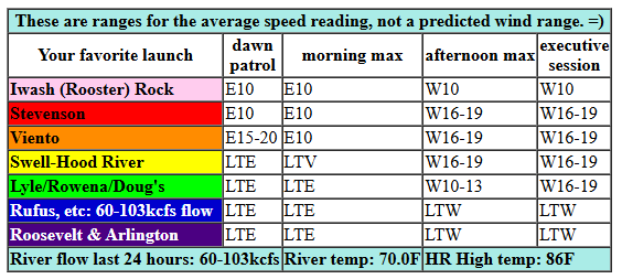
today’s gorge wind forecast
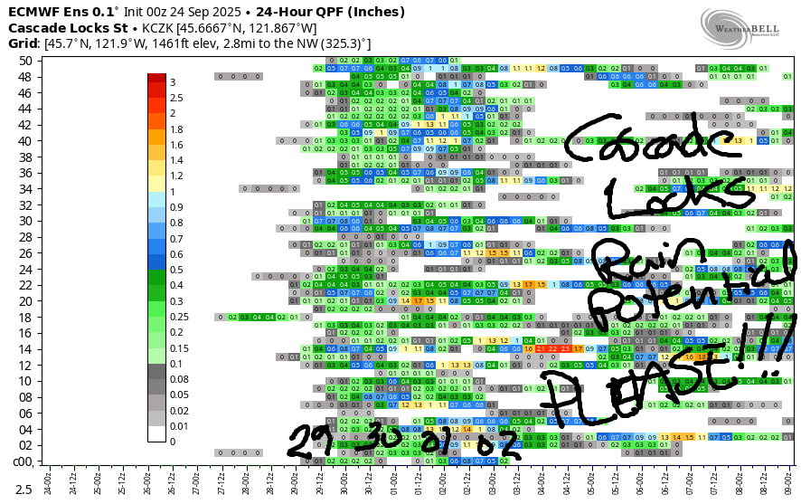
Hi friends! A multi-directional wind day is on tap today, and then we switch to strong westerlies for Thursday. A ton of uncertainty is present in the Gorge wind forecast models from Friday on through Monday. Some of this is due to the timing of a system coming in, and some of it (maybe) is due to fall being a tricky time for the models. Looking into the extended forecast, models suggest cooler weather and intermittent rain for a good portion of next week – that setup is unlikely to result in good wind, but it might result in good mountain biking conditions!
Looking at Wednesday morning… we have a clear, sunny start with pressures of 30.03/30.08. Easterlies were right around 10mph at Iwash and Stevenson with a 19mph reading at Viento when I was typing this. If you want it, get on it. By noon, the wind will be either calm or light westerly. Afternoon wind rises to gusty 16-19mph (westerly) from Stevenson to Mosier with light wind east of Mosier. River flow over the last 24 hours was 60-103kcfs, river temp is 70.0F, and high temp forecast is 86F.
RIVER FLOW FOR SITES BETWEEN AVERY (EAST OF THE DALLES) AND RUFUS: CLICK HERE FOR JOHN DAY DAM FLOW.
RIVER FLOW FOR SITES BETWEEN STEVENSON AND DOUG’S BEACH (WEST OF THE DALLES): CLICK HERE FOR THE DALLES DAM FLOW

tomorrow’s gorge wind forecast
Thursday looks like a big day! A trough (cool air) pushes towards the coast. The ridge (warmer) shifts east to the desert. Some marine clouds form, and high pressure settles offshore. This combo gives us Dawn Patrol in the mid 20s from Viento to Mosier with 17-20mph from Lyle to Rufus. Viento-Mosier builds to 26-29mph for the morning. In the afternoon, depending on what the marine clouds do, we could see the Hatch zone hold, and we could see it drop. Either way, westerlies climb to 28-33mph from Mosier to Rufus and eventually fill in to Arlington. Yay! High temp: 75F for Hood River and 81F out at Rufus.
extended Gorge wind forecast
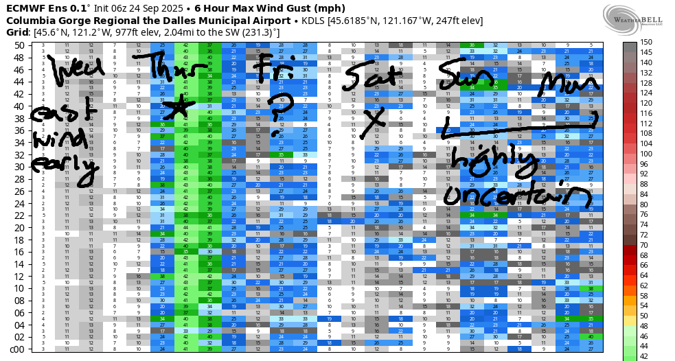
Friday’s ensembles bring quite a bit of uncertainty. The GFS deterministic gives us nearly nothing. As of right now, there’s no way to make an accurate/reliable prediction for Friday. Same for Saturday: lots of uncertainty. If we rely on the ensembles over the GFS-D, Friday looks more likely to be windy than Saturday. Uncertainty continues for Sunday and Monday as a series of weather systems impact the PNW. It’s likely there will be some wind, but it’s also likely to be quite gusty and probably short-lived. For now, it’s probably not worth even penciling things in. Give the extended forecast a bit of time to settle out, and make sure you’ve got a clear block of time for tomorrow. See you on the Nch’i Wana!
Was that helpful? I knew it was! Guess what? All of this crucial work – from your personal wind and snow reports to the invaluable TATAS updates – is made possible by my relentless efforts. Maintaining this labor of love isn’t easy. Each daily forecast takes hours. Website hosting, weather model access, and back-end admin work takes time and money. That’s where you come in.
YOUR CONTRIBUTION MAKES A DIFFERENCE
- SUPPORT ACCURATE, HYPER-LOCAL WEATHER FORECASTING
- ENABLE ACCESS FOR ALL, EVEN THOSE WITH LESS MEANS
- SUPPORT A COOL HUMAN WHO WORKS HARD SO YOU CAN PLAY
Take a moment to click one of the buttons below. Donate $19.99 or more (how much does this forecast enhance your life?) and get the email in your inbox. Whether it’s a renewing subscription (auto-renew) or a one-time donation, every contribution makes a real difference. Help me keep this labor of love alive, so we can all continue playing, commuting, and living in the Gorge with peace of mind and the best weather forecasts possible. Thank you!


Hood River, Oregon 97031


JONES BEACH, SAUVIE ISLAND, & COAST FORECAST
Wind northerly unless otherwise indicated. For coast, it’s North/Central/South with the “central” at approximately Florence. Swell forecast from NWS for central coast. Jones: westerly unless otherwise stated. Sauvie Island: northerly unless otherwise stated. Coast Wednesday: 20-25/25/30, NW swell 7′ at 10 seconds. Thursday: 10-15/15-20/30+, NW 7′ @ 10. Friday: 5-10/15-20/35, NW 6′ @ 15. Jones Wednesday: 16-19. Thursday: 15-18. Friday: LTW. Sauvie Island Wednesday: 14-17. Thursday: 7-10. Friday: 5-8.
BARE BONES HOOD RIVER WEATHER FORECAST
Clear sky today. Temps start in the mid 50s and rise to the mid 80s. Light easterlies early. Moderate westerlies later. No rainbows. Thursday will be partly cloudy then partly high cloudy. Temps start in the mid 50s and rise to the mid 70s. Strong westerlies. No rainbows. Friday will be partly cloudy then clear. Temps start in the upper 40s and rise to the mid 70s. Light westerlies. No rainbows.
TEMIRA’S AWESOME TRAVEL ADVISORY SERVICE – WEDNESDAY
HYPERLOCAL WEATHER FORECAST FOR THE COLUMBIA GORGE
THE DALLES, HOOD RIVER, WHITE SALMON, TROUT LAKE, STEVENSON, CASCADE LOCKS, PARKDALE, ODELL, HUSUM, BZ, MILL A, WILLARD, GOLDENDALE, RUFUS, ARLINGTON, boardman
Good morning, neighbors! While there’s nothing too exciting to talk about this morning, there’s at least SOMETHING to talk about: a big west wind day on Thursday followed by a decent chance of rain starting late this weekend and continuing into next week. Temps finally cool off next week and stay cooled off for a while as a pattern change (finally) arrives to the PNW.
Glenwood this morning
It’s important to do our MOST IMPORTANT THING before we look at the forecast: it’s time for our morning check-in with Glenwood. This morning started off 35 degrees there which doesn’t explain why I woke up with freezing toes, but does explain why everyone in Glenwood has cold feet this morning. Cold feet are merely a symptom of the mind’s worry function. You don’t actually have to believe the worrying; instead, have a little compassion for yourself as a person who sometimes gets cold feet, and go ahead and try that scary thing out anyway. You’ve got this! (Even if you don’t live in Glenwood)
Today’s Gorge weather forecast
For the rest of us today: a somewhat hazy but definitely sunny day. Early temps ranged from that chilly Glenwood reading on up to 59F in Mosier. We’ll max out in the mid 80s (west) near 90 (The Dalles) and mid 80s (Arlington Triangle). The day starts with east wind at 15-20mph near Viento and Stevenson and quickly turns calm. Afternoon wind switches directions. We’ll have west wind at 15-20mph from Stevenson to Mosier.
Tomorrow’s Gorge weather forecast
A few low clouds sneak into the western Gorge, perhaps as far as Hood River, to start Thursday. Offshore, cooler air will be approaching in the form of a trough. That’s a weather trough, not a horse trough. That’s something entirely different, but equally useful, at least to horses. And donkeys. Wednesday’s warmth shifts to the desert. As a result of all this, temps will be down 10 degrees on the west side, still in the mid 80s to the east, and west wind will blast: 25-35mph everywhere between Stevenson and Murdoch in the morning and all the way to the Arlington (equilateral) Triangle in the afternoon. Please do not start a fire. It’s still really dry out there.
Extended Gorge weather forecast
Things settle down on Friday. After a partly cloudy start, the sky clears. Temps max out at 76-79F and westerlies should be under 15mph. Saturday: warmer (78-84F), sunny, and probably not windy, but maybe windy. Or maybe not. Or maybe. Or maybe not. Uncertainty rises after Saturday: somewhere in the Sunday-Tuesday time frame, a cool, wet system (or several) heads this way. Models are quite certain on the “cool” part, but they’re not in agreement on the when/how much wetness part. This is exactly the same forecast as the one I write for my menstrual cycle: no idea when or how much. Generally speaking, there are several days of cooler, potentially moist weather next week. Yay. Safe travels. -TATAS
HEY! DON’T STOP READING! Is this community-focused forecast helpful to you? It sure is! It takes me a couple hours a day to write. Please join your friends and neighbors in contributing to keep it going. Venmo: @thegorgeismygym PayPal: twomirrors@gmail.com USPS: Temira / PO Box 841 / Hood River, Oregon 97031 You can test out the forecast subscription for a few days for free by signing up below. Easy! Do it!
MT HOOD SNOW FORECAST

CURRENTLY ON VACATION. WILL RETURN SOMETIME BEFORE THE START OF SKI SEASON AT MEADOWS, TIMBERLINE AND SKIBOWL. SAME GOES FOR THE NORDIC SKIING SEASON AT MEADOWS AND TEACUP!
