

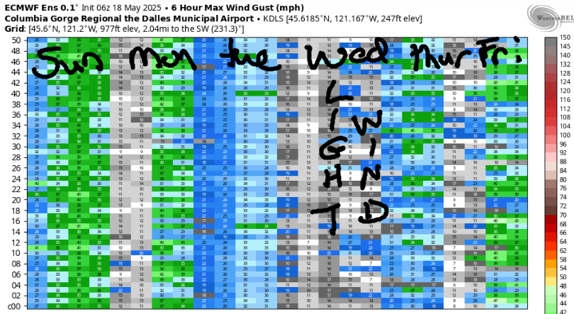
GORGE WIND FORECAST FOR WEDNESDAY
If you’re still seeing yesterday’s and it’s after 9am, try opening this in an incognito window
today’s gorge wind forecast
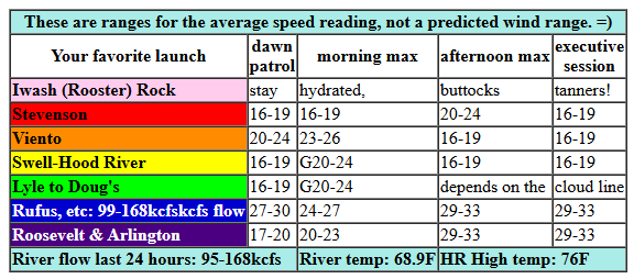
Hi friends! Looks like yesterday evening (when I was burying pumpkin vines) was one of those fun hot-weather, blow-dryer executive sessions. Today looks windy, minus that super-hot weather. Same tomorrow: windy. We’ll see a dip in wind speed on Friday. This weekend looks hot, 90 degrees for Hood River, but thanks to even hotter weather in the desert and somewhat cooler weather on the west side, we’re likely to hang on to westerlies at 17-20mph or better. 17-20mph, as you know, is the new “nuking”!
Wednesday started off with a DDoS attack on my website server. Yay, fun, starting the day with telephone tech support! Pressures were where you want to start the day: 30.12/30.00/29.96 for gradients of 0.12 (PDX-DLS) and 0.04 (DLS-PSC). Westerlies started the day at 17-21 from Viento to Swell, teens near Rowena, and 25-28 in the Maryhill-Rufus zone. Soemtimes this morning, a trough of cool air slides towards BC, and associated cloudy cold front pushes into the west side of OR/WA. Until that happens… expect status quo.
For the afternoon, we’ll see areas from Lyle to Arlington rise to 29-33 in response to the clouds on the west side. Threemile joins at 26-29. West of Lyle, we have some question marks in response to the increasing clouds. Likeliest scenario: a bump into the mid 20s prior to the clouds arriving and then a drop-and-hold to 16-19 under the low clouds. River flow over the last 24 hours was 95-168kcfs, river temp is 68.9F, and high temp forecast is 76F for Hood River and 86F for Arlington.
RIVER FLOW FOR SITES BETWEEN AVERY (EAST OF THE DALLES) AND RUFUS: CLICK HERE FOR JOHN DAY DAM FLOW.
RIVER FLOW FOR SITES BETWEEN STEVENSON AND DOUG’S BEACH (WEST OF THE DALLES): CLICK HERE FOR THE DALLES DAM FLOW

tomorrow’s gorge wind forecast
Westerlies linger on Thursday thanks to a supportive cross-Cascade temp gradient and cool air refreshing the west side from a nice little cold pocket off the coast. Expect post-frontal westerlies at 12-15mph from Stevenson to Arlington to start the day. Don’t be drawn out east – the focus will be the west side. Midday wind rises to 20-23 from Viento to Mosier with 17-20 at Avery. Models suggest the morning clouds will burn off, which knocks Stevenson-Hood River down to gusty 16-19 in the afternoon. Mosier to Doug’s holds at 20-23, and Avery falls to 14-17. High temp: 80F with partly cloudy sky early and sun later.
extended Gorge wind forecast
Hotter weather and lesser temp gradients are forecast on Friday. That said, it looks like we could see just enough oomph (technical term) in the afternoon for westerlies. The day starts light, with just 10mph and only between Stevenson and Swell. It’s going to take some time, so plan other activities midday. Afternoon/evening wind rises to 17-20 from Stevenson to Mosier with 11-14 between Lyle and Rowena. High temp: 91F for Hood River.
Now let’s look at the weekend and next Monday: strong offshore high pressure lingers, and triple-digit heat sets up in the desert. Despite temps hovering around 90 in Hood River, we’ll see westerlies. Models have quite a bit of range, but that may be due to the closest ensemble data point being at The Dalles: it’s not going to be all that windy there, but we should see 20mph or more near Hood River. We start to see a bit more uncertainty (but no less heat) for Tuesday and Wednesday. Uncertainty amplifies next Thursday as models struggle to resolve the breakdown of the heat wave and associated ridge of high pressure. Somewhere in there when temps fall, we have a shot at a big day. Between now and then, enjoy the westerlies. Stay hydrated. See you on the Nch’i Wana!
Was that helpful? I knew it was! Guess what? All of this crucial work – from your personal wind and snow reports to the invaluable TATAS updates – is made possible by my relentless efforts. Maintaining this labor of love isn’t easy. Each daily forecast takes hours. Website hosting, weather model access, and back-end admin work takes time and money. That’s where you come in.
YOUR CONTRIBUTION MAKES A DIFFERENCE
- SUPPORT ACCURATE, HYPER-LOCAL WEATHER FORECASTING
- ENABLE ACCESS FOR ALL, EVEN THOSE WITH LESS MEANS
- SUPPORT A COOL HUMAN WHO WORKS HARD SO YOU CAN PLAY
Take a moment to click one of the buttons below. Donate $19.99 or more (how much does this forecast enhance your life?) and get the email in your inbox. Whether it’s a renewing subscription (auto-renew) or a one-time donation, every contribution makes a real difference. Help me keep this labor of love alive, so we can all continue playing, commuting, and living in the Gorge with peace of mind and the best weather forecasts possible. Thank you!


Hood River, Oregon 97031


JONES BEACH, SAUVIE ISLAND, & COAST FORECAST
Wind northerly unless otherwise indicated. For coast, it’s North/Central/South with the “central” at approximately Florence. Swell forecast from NWS for central coast. Jones: westerly unless otherwise stated. Sauvie Island: northerly unless otherwise stated. Coast Wednesday: LTW/LTNW/N15-20, NW swell 3′ at 9 seconds. Thursday: LTNW/10-15/30, NW swell 4′ @ 8 seconds. Friday: 15-20/20/35, NW 6′ @ 7. Jones Wednesday: LTW. Thursday: 9-11. Friday: 18-21. Sauvie Island Wednesday: 7-10. Thursday: 10-13. Friday: 14-17.
BARE BONES HOOD RIVER WEATHER FORECAST
Clear sky this morning adds low clouds. Temps start in the mid 60s and end in the mid 70s. Moderately strong westerlies. No rainbows. Thursday will be cloudy then mostly clear. Temps start in the upper 50s and rise to 80. Light westerlies early. Moderate westerlies later. No rainbows. Friday will be partly cloudy then mostly clear. Temps start in the upper 50s and rise to the low 90s. Light west wind early. Moderate westerlies. No rainbows.
TEMIRA’S AWESOME TRAVEL ADVISORY SERVICE
HYPERLOCAL WEATHER FORECAST FOR THE COLUMBIA GORGE
THE DALLES, HOOD RIVER, WHITE SALMON, TROUT LAKE, STEVENSON, CASCADE LOCKS, PARKDALE, ODELL, HUSUM, BZ, MILL A, WILLARD, GOLDENDALE, RUFUS, ARLINGTON, boardman
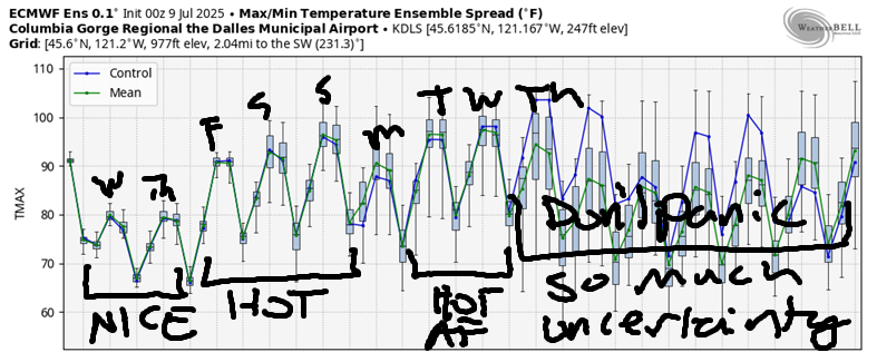
Good morning, neighbors! A couple cooler, but not cool, days are on tap, and then we’re right back into hot weather through next Wednesday. Beyond that, models struggle with the timing of a cooldown and have a spread of almost 20 degrees in the possible high temps next Thursday. Some of you are probably delighted by this heat. I wish I was like you!
glenwood this morning
Speaking of heat, let’s check in with Glenwood, where it’s always cold enough to light a fire. This morning: 49 degrees.
today’s gorge weather forecast
Weather for Wednesday: probably written in quite a boring way as I’m on the phone with GoDaddy as my website is down again. Oh neat. It’s a DDoS attack on the server – my favorite way to start the day! Temps today start in the mid 60s, warm, but cool enough to have the windows open. hiile it’s clear this morning, an approaching front should nudge clouds into the Gorge as far east as Hood River mid morning. Ah yes. Clouds. Out east, we’ll have sunshine. West wind rises to 20-25mph between Stevenson and Hood River with 25-35mph from Lyle to Arlington and 25-30mph to Boardman. Temps: 76 (west), 85 (The Dalles), and 95 (watermelon zones).
thursday’s gorge weather forecast
On Thursday, we’ll have another pleasant day. After a party cloudy start west of Hood River, the sky turns mostly clear everywhere. Morning temps rise from the upper 50s to… 80 (west), 85 (The Dalles), and 89 (watermelon zones). West wind will be 15mph between Stevenson and Arlington in the morning . Afternoon wind will be 20mph between Stevenson and Hood River with 20-25mph from Mosier to The Dalles with 15mph east of The Dalles.
extended gorge weather forecast
Friday: sunny, 5-6 degrees warmer than Thursday, and less windy: 5-10mph or less early with 15-20mph between Stevenson and Mosier in the afternoon. Areas to the east will have 10mph or less. On to the weekend… high temps hold around 90 on the west side and rise to 100 on the east side. Thanks to this temperature gradient, we’ll be stuck with west wind on the weekend. It won’t be super strong, but 20mph seems like a reasonable call at this point. Hot weather sticks around through at least next Wednesday. Safe travels. -TATAS
HEY! DON’T STOP READING! Is this community-focused forecast helpful to you? It sure is! It takes me a couple hours a day to write. Please join your friends and neighbors in contributing to keep it going. Venmo: @thegorgeismygym PayPal: twomirrors@gmail.com USPS: Temira / PO Box 841 / Hood River, Oregon 97031 You can test out the forecast subscription for a few days for free by signing up below. Easy! Do it!
