

GORGE WIND FORECAST
today’s gorge wind forecast
Hi friends! The rest day you’ve been waiting for is here. Take advantage of it, because there’s not much sign of rest in the upcoming seven to ten days of gorge wind forecast. Strongest days of the next six are Thursday and potentially Sunday or Monday (Monday’s the best chance of a big day as of now). Temps will be generally warmish through Sunday, and then a cooldown (not quite the cooldown you were hoping for, but probably good enough) is in the cards for Memorial Day.
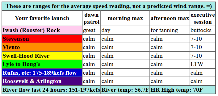
Let’s take a look at Wednesday, shall we? Pressures early were 30.28/30.24/20.23, but we’ll lose what gradient we do have as temps equalize across the Cascades and a low hangs off the coast. Most of the day will be calm or nearly so. We could see westerlies at 7-10mph between Stevenson and Swell this evening, but generally speaking, you can plan on activities that are fun when the wind shuts off. River flow over the last 24 hours was 151-197kcfs, river temp is 56.7F, and high temp forecast is 70F.

tomorrow’s gorge wind forecast
Thursday sees a low move from somewhere to the south into Idaho. Offshore, we get weak high pressure and moving parts. Not ideal, but good enough for wind. The day starts with 13-16 from Stevenson to Arlington. Mid-morning wind rises to gusty 21-24 from Stevenson to Doug’s with 10-13 to the east. In the afternoon, we’ll have 24-27 from Lyle (maybe Mosier) to Arlington, perhaps to Threemile. Areas west of Mosier will drop to gusty 16-19 in the afternoon. High temp: 65F with mostly cloudy sky in the morning and partly cloudy sky in the afternoon.
extended Gorge wind forecast
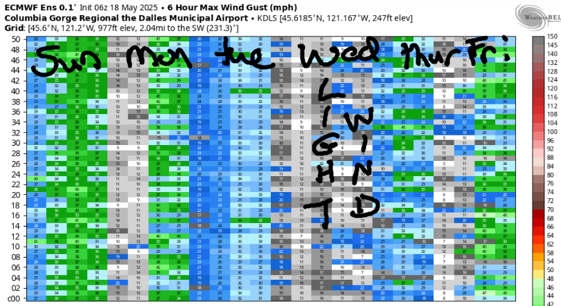
The “moving parts” setup continues on Friday as a low moves towards the north part of BC and a front approaches the coast. Early in the morning, Viento to Swell read 11-14. East of Swell: light. By late morning, we should have 16-19 from Stevenson to Doug’s with 10-13 at Avery and less than 10mph to the east. Wait a little longer, and you’ll have 18-21 from Stevenson to Hood River with 20-23 from Mosier to Avery. East of there: not enough. High temp: 71F and partly cloudy.
Saturday looks like the lightest of the holiday weekend – there’s not much to see on the ensembles, but that’s because the focus will be near Hood River and the ensemble pinpoints The Dalles. We’re probably looking at upper teens to (if we’re lucky) low 20s in the Corridor (close to Hood River). Much warmer weather in the desert on Sunday (especially in central OR) gives us much stronger thermal support and stronger wind. Let’s call it 24-27 for now, although there’s a fair bit of range in the possibilities. Models are pretty certain we’ll have a cooldown on Monday, and they are relatively certain about strong westerlies (probably in the Corridor). We’ll have to wait for more clarity. Uncertainty increases as we move beyond the holiday weekend, but there are hints of a big west wind day way out towards next Wednesday/Thursday, the 28th and 29th. We’ll watch that closely, won’t we? Have a great day today. See you on the Nch’i Wana!
Was that helpful? I knew it was! Guess what? All of this crucial work – from your personal wind and snow reports to the invaluable TATAS updates – is made possible by my relentless efforts. Maintaining this labor of love isn’t easy. Each daily forecast takes hours. Website hosting, weather model access, and back-end admin work takes time and money. That’s where you come in.
YOUR CONTRIBUTION MAKES A DIFFERENCE
- SUPPORT ACCURATE, HYPER-LOCAL WEATHER FORECASTING
- ENABLE ACCESS FOR ALL, EVEN THOSE WITH LESS MEANS
- SUPPORT A COOL HUMAN WHO WORKS HARD SO YOU CAN PLAY
Take a moment to click one of the buttons below. Donate $19.99 or more (how much does this forecast enhance your life?) and get the email in your inbox. Whether it’s a renewing subscription (auto-renew) or a one-time donation, every contribution makes a real difference. Help me keep this labor of love alive, so we can all continue playing, commuting, and living in the Gorge with peace of mind and the best weather forecasts possible. Thank you!


Hood River, Oregon 97031


JONES BEACH, SAUVIE ISLAND, & COAST FORECAST
Wind northerly unless otherwise indicated. For coast, it’s North/Central/South with the “central” at approximately Florence. Swell forecast from NWS for central coast. Jones: westerly unless otherwise stated. Sauvie Island: northerly unless otherwise stated. Wednesday: 20-25/20-25/20-25, W swell 7′ at 11 seconds. Thursday: NW15/N15/N20, NW 4′ @ 9. Friday: NW10/N15/N25, W 3′ @ 8. Jones Wednesday: 18-21. Thursday: LTW. Friday: 21-24. Sauvie Island Wednesday: 10-13. Thursday: LTW. Friday: LTN.
BARE BONES HOOD RIVER WEATHER FORECAST
Clear sky this morning adds high clouds later. Temps start in the upper 40s and rise to 70. Calm wind. No rainbows. Thursday will be mostly cloudy with a little drizzle then partly cloudy. Temps start in the upper 40s and rise to the mid 60s. Moderately strong westerlies. 92% chance of rainbows. Friday will be partly cloudy then mostly clear. Temps start in the mid 40s and rise to the low 70s. Moderate westerlies. No rainbows.
TEMIRA’S AWESOME TRAVEL ADVISORY SERVICE – WEDNESDAY (FOR REALS THS TIME) 5/21
HYPERLOCAL WEATHER FORECAST FOR THE COLUMBIA GORGE
THE DALLES, HOOD RIVER, WHITE SALMON, TROUT LAKE, STEVENSON, CASCADE LOCKS, PARKDALE, ODELL, HUSUM, BZ, MILL A, WILLARD, GOLDENDALE, RUFUS, ARLINGTON, boardman

Good morning, neighbors! Goodness – I’m chatty on the text messages this morning and not getting the forecast done, and y’all area waiting patiently while I socialize. Thank you for your patience while I seek out cattle panels, plan a moving coffee, and now go outside to thank the sun for rising and also for not going supernova last night. Be right back.
GLENWOOD’S MORNING AND TODAY’S GORGE WEATHER FORECAST
K. I’m back. Guess what happened in Glenwood this morning? A frost: 30 degrees there to start the day. Up in the Upper Hood River Valley, the location known as Parkdale and Mt. Hood, temps ranged from 33-36F. Down here along the Nch’i Wana, it was 49F at my house, just the right temp to open the door and let the cat out on a leash. We’ll see temps surge to 70 degrees today (perfect) along with light/variable wind. Late in the day, high clouds move in. It looks like the metro area will cloud over too, which makes a stunning sunset less likely, but still, I’ll be watching for it. You should too.
THURSDAY’S GORGE WEATHER FORECAST
A weak little troughy thing tonight sets us up for a wee bit of drizzle on Thursday morning. Some ensemble members even take that drizzle as far east as The Dalles with a trace to 0.2” forecast. Drizzle finishes up by 10am near Hood River and early afternoon for the far western Gorge. Thanks tot he cloudy start, temps only make it to the mid 60s after a 50 degree start. Sky coverage turns partly cloudy in the afternoon. Westerlies rise from 10-15mph (Stevenson to Arlington) in the morning to 20-25mph (Stevenson to Arlington) in the afternoon.
FRIDAY’S GORGE WEATHER FORECAST
Friday kicks off partly cloudy and turns mostly clear. Temps start in the mid 40s and make it to 70 or so, thanks to the sun being just the right kind of star at just the right distance to allow water-based life to flourish. Isn’t that a fucking marvel? It truly is! Westerlies rise from 10-15mph in the morning (Stevenson to Hood River) to 20-25mph in the afternoon (Stevenson to Avery, less farther east).
MEMORIAL DAY WEEKEND WEATHER FORECAST
For your Memorial Day weekend, you’ll have warmer weather: upper 70s on Saturday and mid 80s on Sunday. Both days look breezy, especially west of The Dalles. I was going to have a Memorial Day BBQ on Monday, but with cooling forecast, there’s going to be Wind Johnnying happening, and that’s no time to try and plan for a rib roast. Which is like a BBQ, only meatier. Looking into the long-range forecast, we’ve got generally seasonable weather. While there’s lots and lots and lots of range in the temps (10+ degree spread starting Monday), the interquartile range (I love saying that – it’s almost as good as “irrational exuberance”) keeps us mostly under 80 degrees and always under 85 degrees for the next two weeks. Of course it’s possible that something could change, but this is pretty fucking lovely in my opinion. And it’s so dang good for getting the garden going. Happy, happy, happy. So much happiness! Safe travels. -TATAS
HEY! DON’T STOP READING! Is this community-focused forecast helpful to you? It sure is! It takes me a couple hours a day to write. Please join your friends and neighbors in contributing to keep it going. Venmo: @thegorgeismygym PayPal: twomirrors@gmail.com USPS: Temira / PO Box 841 / Hood River, Oregon 97031 You can test out the forecast subscription for a few days for free by signing up below. Easy! Do it!
