

GORGE WIND FORECAST
If you’re still seeing yesterday’s and it’s after 9am, try opening this in an incognito window
today’s gorge wind forecast
Hi friends! Not much happens in wind world over the next few days – early easterlies today, light westerlies the next two days – but then we have solid easterlies for the weekend. Other fun things to do: the Nordic Ski Swap on Saturday evening in Hood River and a Whoopdee Trail work party on Sunday.
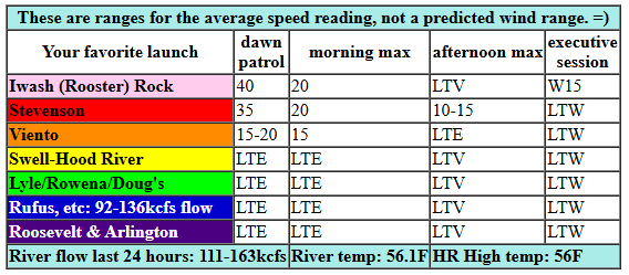
To start today (it’s Wednesday), a deep low (968mb!) swings north in the offshore waters. This started the day with easterlies nearing 40mph at Iwash (Rooster) Rock, 35mph at Stevenson, and 17mph at Viento. Thanks to iWind/iKite for the readings! The wind drops fast: by 10am, we’ll have 20mph at Stevenson and 15mph at Iwash. Afternoon brings light westerlies, but they should remain under 15mph and probably under 10mph. River flow over the last 24 hours was 92-163kcfs, river temp is 56.1F, and high temp forecast is 56F for Hood River.
RIVER FLOW FOR SITES BETWEEN AVERY (EAST OF THE DALLES) AND RUFUS: CLICK HERE FOR JOHN DAY DAM FLOW.
RIVER FLOW FOR SITES BETWEEN STEVENSON AND DOUG’S BEACH (WEST OF THE DALLES): CLICK HERE FOR THE DALLES DAM FLOW

tomorrow’s gorge wind forecast
Thursday kicks off with 7-10mph west wind from Stevenson to Swell, lighter wind from Hood River to Doug’s, and 15-18mph westerlies from Avery to Boardman. The wind drops off midday and picks up again after dark. High temp: 56F with drizzle in the morning and rain in the afternoon.
extended Gorge wind forecast
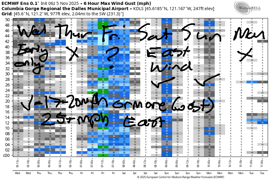
On Friday, we’ll have westerlies under 10mph west of The Dalles with a brief period of 19-22mph possible mid-morning from Avery to Arlington. Afternoon wind falls below 15mph out east and holds under 10mph west of The Dalles. In other words, not so much wind but maybe a brief opportunity out in the desert. Saturday and Sunday both bring moderately strong east wind. We’re probably looking at 35mph (Iwash) on Saturday and 30mph on Sunday, but this is still a ways out and likely to change. Monday: probably not windy as we start to transition back to a more active weather pattern. I’ll leave it there for now. See you out in the Gorge Gym for something fun!
Was that helpful? I knew it was! Guess what? All of this crucial work – from your personal wind and snow reports to the invaluable TATAS updates – is made possible by my relentless efforts. Maintaining this labor of love isn’t easy. Each daily forecast takes hours. Website hosting, weather model access, and back-end admin work takes time and money. That’s where you come in.
YOUR CONTRIBUTION MAKES A DIFFERENCE
- SUPPORT ACCURATE, HYPER-LOCAL WEATHER FORECASTING
- ENABLE ACCESS FOR ALL, EVEN THOSE WITH LESS MEANS
- SUPPORT A COOL HUMAN WHO WORKS HARD SO YOU CAN PLAY
Take a moment to click one of the buttons below. Donate $19.99 or more (how much does this forecast enhance your life?) and get the email in your inbox. Whether it’s a renewing subscription (auto-renew) or a one-time donation, every contribution makes a real difference. Help me keep this labor of love alive, so we can all continue playing, commuting, and living in the Gorge with peace of mind and the best weather forecasts possible. Thank you!


Hood River, Oregon 97031


MT HOOD SNOW FORECAST

Hey skiers and snowboarders! “Not much” is the Mt Hood snow forecast for the next week or so, but the middle of the month appears (no promises, but there are signs) cooler and wetter. Wednesday looks rainy on Mt. Hood with showers in the afternoon and a little wet snow overnight. The snow level will be 6500′ this morning, 5500′ this afternoon, and 5000-5500′ overnight. About 0.3” rain is forecast today followed by 0.4” to 0.6” rain or snain or mixed precip overnight. Wind: SW 25-50 all day becoming WSW 40-50 overnight.
Thursday starts with mixed precip. That switches to rain by afternoon as the snow level rises from 5250′ to 7000′. It drops to 4000′ after midnight, but most of the precip will be done by then. We’re expecting 0.2” mixed precip during the day followed by 1.1” rain overnight. The tail end of that could drop 1-2” of snow. More likely 1” or less than 2”.. Wind: WSW 40-50 in the morning fading to SW 25-45 in the afternoon and becoming W 35 overnight.
A few flurries Friday morning give way to partly cloudy sky. The snow level will be 4000′ early, 3500′ in the afternoon, and 3000′ overnight. 1-2” of snow is possible before the precip stops. Wind: W 35 early, W 15 in the afternoon, and S 5-15 after midnight. Saturday looks sunny with the free air freezing level rising from 3000′ to 12,000′. Light wind. The next couple days after that also look warm and sunny. That’s it for now. Snow will come eventually! And when it does, I’ll see you up there to play in it!
BARE BONES HOOD RIVER WEATHER FORECAST
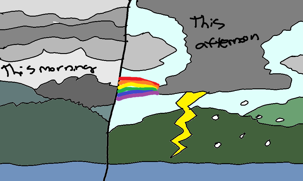
Clouds this morning with drizzle. Showers, heavy at times, with a chance of thunder this afternoon. Light easterlies turning to light westerlies. 98% chance of rainbows. Thursday will be rainy. Temp start in the mid 40s and rise to the mid 50s. Light westerlies. 99% chance of rainbows. Friday will have a little drizzle early then dry weather with sunshine. Temps start in the low 40s and rise to the mid 50s. Light westerlies. 84% chance of rainbows.
TEMIRA’S AWESOME TRAVEL ADVISORY SERVICE
HYPERLOCAL WEATHER FORECAST FOR THE COLUMBIA GORGE
THE DALLES, HOOD RIVER, WHITE SALMON, TROUT LAKE, STEVENSON, CASCADE LOCKS, PARKDALE, ODELL, HUSUM, BZ, MILL A, WILLARD, GOLDENDALE, RUFUS, ARLINGTON, boardman
Good morning, neighbors. Gosh golly it sure does look like November out there. And so it shall remain through Friday morning. Models have taken a decidedly un-November step and reached a consensus of “dry” for the weekend. Don’t you worry, tho, we’ll be back to wet for the latter half of next week.
Glenwood this morning & today’s Gorge weather forecast
But first we shall check in with Glenwood: 42 degrees and just as dreary as it is where you are. Or perhaps it’s not dreary. Perhaps it’s soothing and relaxing? If this is relaxing, the rest of the day will be too: a warm front is followed by a cold front, and clouds stick around. On the radar, this will look like a big blue wave… kinda like we saw on the ground yesterday. Afternoon weather: unstable and filled with showers, heavy at times. Thunderstorms are possible. Hail: possible. Temps rise to the mid 50s (west) and upper 50s (The Dalles and areas to the east). Wind: easterlies at 40mph near Iwash Rock, 35mph near Stevenson, and light/variable most places this morning. Afternoon: light westerlies, which will result in sunbreaks and rainbows. Given the likelihood of heavy showers, double rainbows are likely too!
Thursday’s Gorge weather forecast
Showers continue overnight especially west of Mosier. Drizzle returns as far east as Biggs on Thursday morning. A brief break (maybe) gives way to the next round of widespread, moderate rain from early afternoon into the night. Temps start out in the mid 40s on Thursday with a snow level of 5500′. Afternoon: 56F to the west, 60F in the Dalles, and 63F in the desert with the snow level rising to 7000′. Wind will be light westerly. This, of course, releases the rainbows from their cages. Look out!
Friday’s Gorge weather forecast & the extended Gorge weather forecast
Drizzle Friday morning lingers west of Wyeth. Everyone else: cloudy to the west and clear to the east in the morning. Mostly clear in the afternoon. Temps start in the low 40s and climb to 54-58F under a barrage of sunbeams. Fortunately sunbeams are really, really light and won’t leave bruises when they land on you. Wind: light to moderate westerlies. Saturday, Sunday, and probably Monday look dry with east wind.
Temps aloft will be quite warm. While we’d normally expect Nothing clouds with this setup, models currently indicate just enough high-level clouds to limit radiational cooling and protect us from Nothing. Fingers crossed – high clouds and filtered sun seem like nice weekend weather to me! I have plans to make a really big compost pile! Safe travels. -TATAS
HEY! DON’T STOP READING! Is this community-focused forecast helpful to you? It sure is! It takes me a couple hours a day to write. Please join your friends and neighbors in contributing to keep it going. Venmo: @thegorgeismygym PayPal: twomirrors@gmail.com USPS: Temira / PO Box 841 / Hood River, Oregon 97031 You can test out the forecast subscription for a few days for free by signing up below. Easy! Do it!
JONES BEACH, SAUVIE ISLAND, & COAST FORECAST
ON WINTER VACATION UNLESS DESPERATELY NEEDED.
