

GORGE WIND FORECAST
If you’re still seeing yesterday’s and it’s after 9am, try opening this in an incognito window
today’s gorge wind forecast
Hi friends! Happy hump day – all ya gotta do is get over today’s hot and not-so-windy hump. After today, westerlies return and stick around for a good long while! While you’re out in the river over the next few days, especially if you’re doing a N/S sport like windsurfing or winging or kiting, keep an eye upriver for all the visitors and locals doing E/W paddling for the Gorge Downwind Champs, not to mention all the SUP foilers, parawingers, and other downwinders going perpendicular to the old usual direction of fun. That’s right – here in the Gorge, we do fun in all directions of the compass!
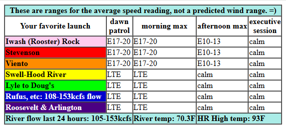
Looking at Wednesday… we start with gradients of 29.90/29.98/29.98 for E 0.08 (PDX-DLS). We’ll see east wind at 17-20mph this morning at Iwash (Rooster) Rock, Stevenson, Home Valley, and Viento. By late morning or early afternoon, the wind drops to 10-13mph, and then it goes calm a few hours later. At that point, you can switch from wind sports to sculling, waterskiing, and other glassy-river activities like floating around on a giant unicorn. River flow over the last 24 hours was 105-153kcfs, river temp is 70.3F, and high temp forecast is 93F for Hood River with clear sky.
RIVER FLOW FOR SITES BETWEEN AVERY (EAST OF THE DALLES) AND RUFUS: CLICK HERE FOR JOHN DAY DAM FLOW.
RIVER FLOW FOR SITES BETWEEN STEVENSON AND DOUG’S BEACH (WEST OF THE DALLES): CLICK HERE FOR THE DALLES DAM FLOW

tomorrow’s gorge wind forecast
Thursday brings back the westerlies at 20mph+, strongest near Hood River in the morning and strongest near Lyle and Rowena in the afternoon. TLDR: a southerly wind reversal on the coast helps cool things down out there. This, combined with offshore high pressure and a heat low in the desert drives up the cross-Cascade thermal gradients: 91 degrees in Portland and 98 degrees out in the desert. TJ’s Dawn Patrol looks like 21-24 from Viento to Mosier (14-17 at Stevenson, 16-19 in Hood River). Mid-morning wind fills in at 21-24 from Stevenson to Mosier with 17-20 from Lyle to Rufus. With heat still forecast in the metro area, the Stevenson-Hood River zone is likely to drop to 17-20 in the afternoon while Mosier-Rufus rises to 21-24. Arlington joins in late in the day. Remember that this forecast predicts the iWind sensor readings, and that sensors out east read high compared to the Swell sensor. In other words, 21-24 for areas east of The Dalles is more like 17-19 at the Hatch.
extended Gorge wind forecast
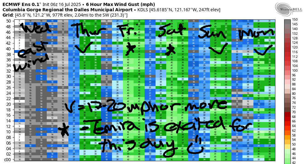
Friday looks windier; low 20s everywhere in the morning with upper 20’s everywhere from Stevenson to Arlington in the afternoon. TLDR: a cool trough sets up along the coast on Friday. While it’s probably not going to be strong enough to create marine clouds, it will keep the west side cool, and that’ll keep the wind going. Early westerlies should be 21-24 from Stevenson to Mosier (more at Viento) with 18-21 from Lyle to Arlington. Westerlies build to 24-27mph from Stevenson to Hood River with 27-31 (maybe a bit more at times) from Mosier to Arlington. Threemile joins with 24-27+ late afternoon. The wind dips a few mph after 5pm, but will still be plenty strong everywhere between Stevenson and Threemile. High temp: 88F for Hood River and 95F for Arlington.
For the extended forecast, Saturday through Monday, we’ve got strong westerlies each day. TLDR: the cool trough persists along the coast/west side, offshore high pressure lingers, and heat continues in the desert. While the location of the strongest wind will shift around, each day brings (probably) 25-30mph at some location or another. Generally speaking, the zone from Lyle to Rufus will shine for this time period, but I’m not ruling out the Hatch. Worth noting: models are hinting at marine clouds Saturday and Sunday, which could 1) push the wind out east and 2) create a situation where reality is likely to beat the model forecast. Hmmm… seems like a pretty darn nice stretch of wind, doesn’t it? Stay cool today, and I’ll see you on the Nch’i Wana!
Was that helpful? I knew it was! Guess what? All of this crucial work – from your personal wind and snow reports to the invaluable TATAS updates – is made possible by my relentless efforts. Maintaining this labor of love isn’t easy. Each daily forecast takes hours. Website hosting, weather model access, and back-end admin work takes time and money. That’s where you come in.
YOUR CONTRIBUTION MAKES A DIFFERENCE
- SUPPORT ACCURATE, HYPER-LOCAL WEATHER FORECASTING
- ENABLE ACCESS FOR ALL, EVEN THOSE WITH LESS MEANS
- SUPPORT A COOL HUMAN WHO WORKS HARD SO YOU CAN PLAY
Take a moment to click one of the buttons below. Donate $19.99 or more (how much does this forecast enhance your life?) and get the email in your inbox. Whether it’s a renewing subscription (auto-renew) or a one-time donation, every contribution makes a real difference. Help me keep this labor of love alive, so we can all continue playing, commuting, and living in the Gorge with peace of mind and the best weather forecasts possible. Thank you!


Hood River, Oregon 97031


JONES BEACH, SAUVIE ISLAND, & COAST FORECAST
Wind northerly unless otherwise indicated. For coast, it’s North/Central/South with the “central” at approximately Florence. Swell forecast from NWS for central coast. Jones: westerly unless otherwise stated. Sauvie Island: northerly unless otherwise stated. Coast Wednesday: 20/15-20/S5-10, NW swell 6′ at 8 seconds. Thursday: LTNW/LTNW/N20, NW swell 7′ @ 10. Friday: LTNW/15-20/15-20, NW 6′ @ 10. Jones Wednesday: 19-22. Thursday: 16-19. Friday: 18-21. Sauvie Island Wednesday: 12-15 > 5pm. Thursday: 7-10. Friday: 14-17.
BARE BONES HOOD RIVER WEATHER FORECAST
Clear sky all day Wednesday. Temps start near 60 and rise to the low 90s. Light easterlies then calm. No rainbows. Thursday will be clear. Temps start in the low 60s and rise to the low 90s. Moderately strong westerlies. No rainbows. Friday will be clear then high cloudy. Temps start in the low 60s and rise to the upper 80s. Moderately strong to strong westerlies. No rainbows.
TEMIRA’S AWESOME TRAVEL ADVISORY SERVICE – WEDNESDAY 7/16
HYPERLOCAL WEATHER FORECAST FOR THE COLUMBIA GORGE
THE DALLES, HOOD RIVER, WHITE SALMON, TROUT LAKE, STEVENSON, CASCADE LOCKS, PARKDALE, ODELL, HUSUM, BZ, MILL A, WILLARD, GOLDENDALE, RUFUS, ARLINGTON, boardman
Good morning, neighbors! A decently decent morning gives way to yet another hot and sunny and calm afternoon today. Starting Thursday, temps slide a bit, and west wind picks up a lot, but not a lot in Hood River, because those lots, even the in-city lots, are too expensive for the west wind to afford. Guess what’s not in the forecast? You got it: no rain. No snow. No ice. But there’s something real nice: the possibility of clouds west of Moiser this weekend!
Glenwood this morning and today’s gorge weather forecast
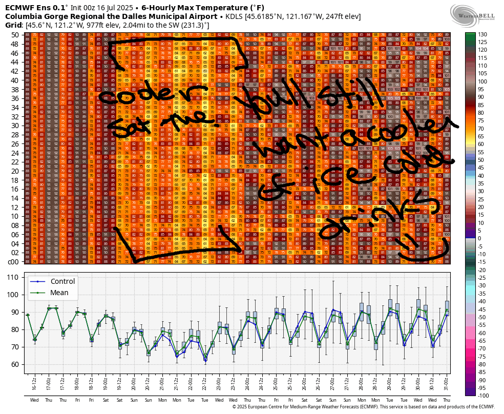
Wednesday will be hot and sunny. The central Gorge and desert top out in the low 90s, and The Dalles and the metro area top out in the upper 90s. This makes Glenwood the place to be today: after a 51 degree start, it’ll actually end up 15 degrees and cloudy with ice skating possible this evening. How is this possible? A wormhole has opened up between the Andes and Glenwood, and cold air is funneling in. Usually the wormhole is closed (it has a leaky seal – that’s why Glenwood is so cold in the mornings), but the recent heat in the Gorge warped the frame, and now extensive cold air is leaking in. Wind today will be E 15-20mph this morning between Pen*s Rock (Iwash, Rooster) and Viento. The wind turns calm this afternoon all through the Gorge and turns westerly overnight.
THURSDAY’S GORGE WEATHER FORECAST
Thus shall we have a breezy Thursday. Morning temps will be around 60 degrees. Afternoon highs rise to 91 (west), 96 (The Dalles), and 98 (out where the watermelons are plumping up in the desert). West wind will be 20-25mph all day from Stevenson to Mosier with 20-25mph in the afternoon from Stevenson east to the Arlington Equilateral Triangle and Roosevelt Rhombus. Clear sky overnight should be good for stargazing – the Alpha Capricornids and their intermittent fireballs are on!
EXTENDED GORGE WEATHER FORECAST
Temps drop a few degrees on the west side on Friday as a trough of cool air approaches from the great white north, land of Cheezies and universal healthcare that’s not tied to employment. Morning temps on Friday will be near 60 – if you convert 60 degrees to years, it puts you five years away from universal healthcare in the USA. Afternoon temps rise to the upper 80s (west), mid 90s (the Dalles), and nearly 100, but not quite, out in the desert where the watermelons grow. Friday will be windy: 25-35mph all through the Gorge. Weekend weather: 80-90 degrees, depending on your location, and windy everywhere, and potentially cloudy for at least part of the day west of Moiser. Don’t. Start. A. Fire. Please. Instead, please go seek out a secondary wormhole that’ll bring us some cooler temps and moisture. Set it up so that the moisture arrives just as the last cherries are delivered to the packing house. Mahalo for your kokua. Safe travels. -TATAS
HEY! DON’T STOP READING! Is this community-focused forecast helpful to you? It sure is! It takes me a couple hours a day to write. Please join your friends and neighbors in contributing to keep it going. Venmo: @thegorgeismygym PayPal: twomirrors@gmail.com USPS: Temira / PO Box 841 / Hood River, Oregon 97031 You can test out the forecast subscription for a few days for free by signing up below. Easy! Do it!
