

GORGE WIND FORECAST
today’s gorge wind forecast
Hi friends! Hopefully you enjoyed your rest day yesterday. Your next chance for enforced rest is Friday, when easterlies return for a brief period. Other than that… west wind today (Wednesday), Thursday, and nuking (real nuking, not Walker nuking!) westerlies for the weekend. Uncertainty increases on Monday, but ensembles generally indicate west wind of some sort in the Gorge wind forecast all of next week.
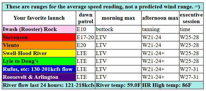
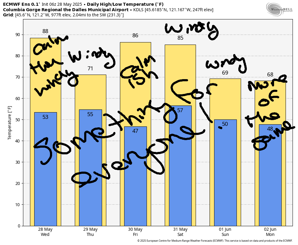
Let’s take a look at today (Wednesday). It’s going to be a warm one! The day started off with a solid easterly gradient of 0.11 (pdx-dls) and easterlies at 18-22mph at Viento, Stevenson, and Iwash (Rooster) Rock. If you want easterlies, you’ll have to get it early, probably before I finish this forecast. An trough (cooler air, to keep it simple) approaches the coast this afternoon and allows a large-scale thermal gradient to develop. Seeking strong wind? Be patient. Just want wind? Anytime after noon or so is your window. By early afternoon, we’ll have 21-24 from Stevenson to Mosier with 10-13 for the Lyle stretch. Late afternoon brings 25-28 from Stevenson to Doug’s with 20-23 from Avery to Arlington. Late in the day, the Avery-Arlington stretch rises to 27-30. We will have some instability this afternoon over the Cascades, which could impact the wind out east. All that said, it looks like a good day, and a great day if your only option is the Executive Session (after 5pm). River flow over the last 24 hours is down notably: 121-218kcfs, river temp is 59F, and high temp forecast is 86F for Hood River and 90F for Arlington.

tomorrow’s gorge wind forecast
That aforementioned trough moves inland on Thursday, and moderate high pressure builds offshore. A bit of drizzle is forecast west of Hood River, which generally shifts the strongest wind east. And models agree! The day starts with 25-28 from Avery to Boardman with 17-20 from Stevenson to Doug’s under partly cloudy sky for that zone. Westerlies build to 27-31 from Avery to Boardman (maybe Lyle-Doug’s too) and bounce up and down west of Avery. As the western Gorge clears out in the afternoon, there should be a period of gusty 20-23 from Viento to Mosier. After 5pm, the wind drops to 14-17 west of Avery and dips to 21-24 from Avery eastward. High temp: 71F for Hood River and 76F for Arlington.
extended Gorge wind forecast
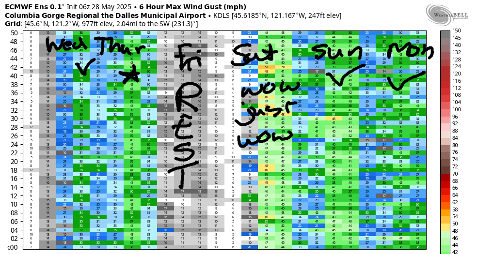
Offshore (easterly) wind is forecast on Friday as a brief ridge builds inland. Easterlies peak mid-morning at 20-25 at Stevenson and Iwash and Home Valley with 15-20 at Viento. They’ll fade quickly and finish the day at 10mph. High temp: 86F and sunny. Nice day for a rest day, and nice day to get some inside work done (like all that work I’ve been procrastinating in favor of meditating and paddling)
Strong high pressure builds offshore Friday night into Saturday morning. The heat low shifts east of the Cascades. Drizzle persists in Stevenson, or just west of there, all day. Reinforcing cool air filters into the PNW from the NW, and that’s accompanied by 30-35kt NW wind aloft. Know why we care? Because all these factors combine to make a near-perfect Gorge setup. 30+ mph is the call pretty much all day, even on that low-reading Swell sensor. East of Mosier, we’re looking at 35mph on the sensors with the potential for upper 30s at Rufus and Arlington.
Sunday’s models don’t show quite as much wind, but super-strong offshore high pressure is likely to make reality beat the models. After a upper-teens to low 20s start near Swell, the wind builds and builds and eventually fills in to Rufus. Mid to upper 20s midday give way to (probably) low 30s. I’ll refine that Sunday forecast as we get closer. A couple things to note for this weekend: there will be a DW SUP/parawing race somewhere one of these days. There will be a short just-for-laughs IKEA FRAKTA blue bag DW race from the Hatch Point probably Saturday at some point. PM me if you’re interesting in participating in the IKEA bag non-event. Racers appreciate you yielding to them and cheering them on! Extended forecast beyond Sunday: oh, probably windy in some manner every day next week, but there’s a lot of uncertainty beyond Sunday. See you on the Nch’i Wana!
Was that helpful? I knew it was! Guess what? All of this crucial work – from your personal wind and snow reports to the invaluable TATAS updates – is made possible by my relentless efforts. Maintaining this labor of love isn’t easy. Each daily forecast takes hours. Website hosting, weather model access, and back-end admin work takes time and money. That’s where you come in.
YOUR CONTRIBUTION MAKES A DIFFERENCE
- SUPPORT ACCURATE, HYPER-LOCAL WEATHER FORECASTING
- ENABLE ACCESS FOR ALL, EVEN THOSE WITH LESS MEANS
- SUPPORT A COOL HUMAN WHO WORKS HARD SO YOU CAN PLAY
Take a moment to click one of the buttons below. Donate $19.99 or more (how much does this forecast enhance your life?) and get the email in your inbox. Whether it’s a renewing subscription (auto-renew) or a one-time donation, every contribution makes a real difference. Help me keep this labor of love alive, so we can all continue playing, commuting, and living in the Gorge with peace of mind and the best weather forecasts possible. Thank you!


Hood River, Oregon 97031


JONES BEACH, SAUVIE ISLAND, & COAST FORECAST
Wind northerly unless otherwise indicated. For coast, it’s North/Central/South with the “central” at approximately Florence. Swell forecast from NWS for central coast. Jones: westerly unless otherwise stated. Sauvie Island: northerly unless otherwise stated. Wednesday: W10/W10/LTV, W swell 5′ at 10 seconds. Thursday: 15-20/20/25, W 6′ @ 10. Friday: 15/15-20/25, W 6′ @ 12. Jones Wednesday: 21-24. Thursday: 10-13. Friday: 21-24 > 5pm. Sauvie Island Wednesday: 14-17. Thursday: LTV. Friday: 10-13.
BARE BONES HOOD RIVER WEATHER FORECAST
Clear sky this morning with a few convective clouds this afternoon. Temps start near 50 and rise to the mid 80s. Calm wind early. Building westerlies that finish strong. 0.23% chance of rainbows. Thursday will be partly cloudy, then cloudy, then mostly clear. Temps start in the mid 50s and rise to 70 or so. Moderate westerlies. 0.5% chance of rainbows. Friday will be mostly clear then clear. Temps start in the upper 40s and rise to the mid 80s. Calm wind early. Light easterlies later. No rainbows.
TEMIRA’S AWESOME TRAVEL ADVISORY SERVICE
HYPERLOCAL WEATHER FORECAST FOR THE COLUMBIA GORGE
THE DALLES, HOOD RIVER, WHITE SALMON, TROUT LAKE, STEVENSON, CASCADE LOCKS, PARKDALE, ODELL, HUSUM, BZ, MILL A, WILLARD, GOLDENDALE, RUFUS, ARLINGTON, boardman
Good morning, neighbors! Hello to another beautiful day in the Gorge. We are really, truly, some of the luckiest people alive. Living here… gosh… so awesome. Weather: those of you wanting some hotter weather will get it today and Friday. Pack a cooler with cool drinks. Those of you wanting cooler weather will get it Thursday, Saturday and Monday. Pack warm drinks those days and leave the cooler at home. Beyond Monday, there’s about 10 degrees of spread in the possibilities, but temps generally stay not-too-hot for the extended forecast. Oh, I should have given a caveat for the folks wanting cooler weather: it always comes with strong wind this time of year!
glenwood’s morning weather and today’s gorge weather forecast
Checking in with our friends in Glenwood this morning, we see them bundled up on the deck looking at Mt. Adams and sipping an extra-hot cup of coffee to combat a 41 degree start. My coffee is just normal temp this morning. How’s yours? As you sip it, consider opening all the doors and windows and storing up some cool air. High temps today will max out in the mid 80s on the west side and right around 90 out in the desert. There’s a slight chance of thundershowers along the Cascade crest and in the desert this afternoon. On to the wind. Heat doesn’t exempt you from the pesky westerlies. They’ll slowly build today and max out this evening and overnight. By evening, we’ll have 25-30mph from Stevenson to The Dalles and 25-35mph from Avery to the Arlington Triangle. In the windy zone, there are at least SIX Indian restaurants. If one of you can figure out how many taquerias are located in the Stevenson-Arlington zone, and then rate them by awesomeness, I’ll buy you tacos. We. Are. So. Lucky.
tomorrow’s gorge weather forecast
Moving on to Thursday… Thursday’s for those of you wanting cooler weather: low 50s in the morning. 70 (west) to 76 (east) degrees in the afternoon. Drizzle is likely near The Dalles for a short period prior to dawn. Drizzle lingers west of Wyeth into late afternoon. Clouds start the day in the west and break up in the afternoon. Don’t be sad – this breakup was long coming and none of the parties were hurt by it other than the usual bit of sadness surrounding a breakup. I broke up with a guy last week, and know what? It wasn’t all that bad, and I wish him well. And now I’m single and on the hunt! Out in the desert Thursday: mostly sunny all day, good weather for running away from a horny and hunting forecaster. West wind will be 15-25mph west of Avery and 25-35mph east of Avery most of the day.
extended gorge weather forecast
Friday: hot and sunny (mid 80s) with calm wind early and moderate east wind in the afternoon. Basically no clouds. If you’ve been wanting to stare at blue sky all day, Friday is your day. Looking at the weekend, we have 70 degree highs and wind. Saturday’s wind will be absolutely blasting all through the Gorge, all the way out to the Arlington Triangle and beyond. Tumbleweeds: super stoked! Wind Johnnies: super stoked! Be stoked for them and you too can be stoked! Sunday’s wind starts slower, but eventually spreads eastward to Amayah’s (the location formerly known as Biggs) and perhaps the Arlington Triangle (formerly known as Arlington) with wind speeds eventually touching or topping 30mph. Next week looks generally nice. “Nice” means it is unlikely to be warmer than 85 degrees and is also likely to be windy. Because it’s my forecast, and I get to decide what “nice” means. If I had my druthers, every day would be like Saturday. Safe travels. -TATAS
HEY! DON’T STOP READING! Is this community-focused forecast helpful to you? It sure is! It takes me a couple hours a day to write. Please join your friends and neighbors in contributing to keep it going. Venmo: @thegorgeismygym PayPal: twomirrors@gmail.com USPS: Temira / PO Box 841 / Hood River, Oregon 97031 You can test out the forecast subscription for a few days for free by signing up below. Easy! Do it!
