

GORGE WIND FORECAST
If you’re still seeing yesterday’s and it’s after 9am, try opening this in an incognito window
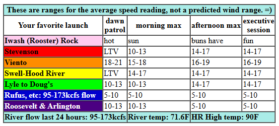
today’s gorge wind forecast
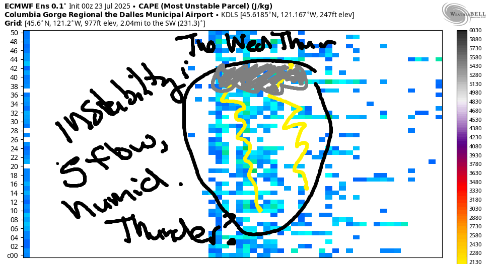
Hi friends! It’s Wednesday, hump day, and this is the hump you need to get over to get to more wind. The Gorge wind forecast has a marginal day today followed by windier conditions Thursday and Friday. Low pressure offshore for the weekend dampens the wind strength but doesn’t shut it down. Looking towards next week, we see less wind as heat builds Monday into Tuesday or perhaps Wednesday. When that heat breaks, there’s a chance of a big wind cooldown day, but models are also hinting at instability and thunderstorms for the Tuesday through Thursday time frame… Let’s dig in to today, shall we?
PSA: don’t be river-recreating in the fire areas. That’s the request of the fire crews. Doug’s Beach is at Level 2 and is still closed per WA State Parks, and the Lyle Sandbar is at Level 3 and also closed. SR 14 remains closed between Bingen and MP 74. Evac levels will not change for the next 5 to 7 days per Klickitat County emergency management. If you see planes scooping near where you’re recreating, clear the water and go somewhere else.
Forecast: Wednesday started with light onshore pressures: 30.01/29.96/29.96 for 0.07 (PDX-DLS) and 0.00 (DLS-PSC). Clear sky extended all the way from the metro area out into the desert, so we’ll have no support from marine clouds today. In addition, we have some atmospheric instability forecast this afternoon (and associated fluffy clouds), which will have a negative effect on the wind quality and strength. Westerlies today start at 18-21 mph near Viento with less than 5mph most other places. By late morning, the wind picks up to 14-17mph between Stevenson and Mosier. Afternoon wind fills in at 14-17mph from Stevenson to Rowena to Avery. East of there: light all day. River flow over the last 24 hours was 95-173kcfs, river temp is 71.6F, and high temp forecast is 90F for Hood River with mostly clear sky.
RIVER FLOW FOR SITES BETWEEN AVERY (EAST OF THE DALLES) AND RUFUS: CLICK HERE FOR JOHN DAY DAM FLOW.
RIVER FLOW FOR SITES BETWEEN STEVENSON AND DOUG’S BEACH (WEST OF THE DALLES): CLICK HERE FOR THE DALLES DAM FLOW

tomorrow’s gorge wind forecast
A trough (cooler air) approaches the Gorge on Thursday. This allows the west side to cool a bit while desert temps gain a few degrees. The combo of offshore high pressure, troughing along the coast, and hot weather in the desert nudges the wind speed up. Expect 19-22mph from Viento to Mosier to start with 11-14mph at Stevenson and also east of Mosier to Arlington. Westerlies build to 22-25mph between Stevenson and Mosier in the morning before filling in at 22-25mph from Stevenson to Arlington early afternoon. Around late morning or early afternoon, Swell-Hood River is likely to drop to 17-20mph as the west side cap dissipates. We then get 25-28mph from Mosier to Arlington for the afternoon session with 22-25mph from Stevenson to Viento. High temp: 86F for Hood River and 93F at Rufus.
extended Gorge wind forecast
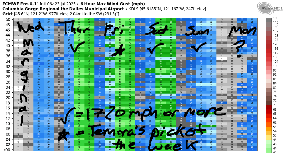
Marine clouds surge into the metro area on Friday and stick around into late morning. High temps lose 5 degrees on the west side and stay in the mid 90s in the desert. It’s looking good for us Wind Johnnies! TJ’s Dawn Patrol starts with 22-25mph from Viento to Mosier with 19-22mph from Avery to Arlington. Stevenson and the Rowena stretch start with 13-16mph. By late morning, we’ll have 25-28mph from Stevenson to Rufus with 20-23 at Arlington. Afternoon wind builds to 27-30mph from Mosier to Arlington. Areas west of Mosier really depend on how long the clouds last in the metro area. Fingers crossed they last all day long, even though models aren’t optimistic about that. High temp: 81F for Hood River and 89F for Rufus.
Looking at the weekend… a weak low slides in to the offshore waters. This disrupts the pattern in several ways, but the outcome is simple to describe: less wind, but still enough for many folks. As of now, we’re looking at 19-22mph on Saturday, 20-23mph on Sunday, and 17-20mph on Monday. Given the dynamic nature of the weekend weather, this is likely to change some. A couple lighter days are likely in the middle part of next week as heat rebuilds. After that: when the cooldown arrives, stronger westerlies are possible. All that said, models suggest southerly flow, humidity, and instability next week from Tuesday to Thursday. If that materializes, the wind is likely to be unreliable, and the weather could get exciting. Let’s leave it there for now. Have a great day on the river!
Was that helpful? I knew it was! Guess what? All of this crucial work – from your personal wind and snow reports to the invaluable TATAS updates – is made possible by my relentless efforts. Maintaining this labor of love isn’t easy. Each daily forecast takes hours. Website hosting, weather model access, and back-end admin work takes time and money. That’s where you come in.
YOUR CONTRIBUTION MAKES A DIFFERENCE
- SUPPORT ACCURATE, HYPER-LOCAL WEATHER FORECASTING
- ENABLE ACCESS FOR ALL, EVEN THOSE WITH LESS MEANS
- SUPPORT A COOL HUMAN WHO WORKS HARD SO YOU CAN PLAY
Take a moment to click one of the buttons below. Donate $19.99 or more (how much does this forecast enhance your life?) and get the email in your inbox. Whether it’s a renewing subscription (auto-renew) or a one-time donation, every contribution makes a real difference. Help me keep this labor of love alive, so we can all continue playing, commuting, and living in the Gorge with peace of mind and the best weather forecasts possible. Thank you!


Hood River, Oregon 97031


JONES BEACH, SAUVIE ISLAND, & COAST FORECAST
Wind northerly unless otherwise indicated. For coast, it’s North/Central/South with the “central” at approximately Florence. Swell forecast from NWS for central coast. Jones: westerly unless otherwise stated. Sauvie Island: northerly unless otherwise stated. Coast Wednesday: NNW10/NNW10-15/N5-10, NW swell 3′ at 8 seconds. Thursday: LTNW/NW5-10/N15, NW 3′ @ 9. Friday: NW5-10/N10/N20-25, NW 4′ @ 8. Jones Wednesday: 15-18. Thursday: 16-19. Friday: 15-18. Sauvie Island Wednesday: 8-11. Thursday: 10-13. Friday: 8-11.
BARE BONES HOOD RIVER WEATHER FORECAST
Clear this morning with some fluffy clouds this afternoon in mostly clear sky. Temps start near 60 and rise to 90. Moderate westerlies. No rainbows. Thursday will be sunny. Temps start in the low 60s and rise to the mid 80s. Moderate westerlies. No rainbows. Friday will be mostly clear then clear. Temps start in the low 60s and rise to the low 80s. Strong westerlies. No rainbows.
TEMIRA’S AWESOME TRAVEL ADVISORY SERVICE – WEDNESDAY 7/23
HYPERLOCAL WEATHER FORECAST FOR THE COLUMBIA GORGE
THE DALLES, HOOD RIVER, WHITE SALMON, TROUT LAKE, STEVENSON, CASCADE LOCKS, PARKDALE, ODELL, HUSUM, BZ, MILL A, WILLARD, GOLDENDALE, RUFUS, ARLINGTON, boardman
Good morning, neighbors! Hotter-than-average weather continues for a couple more days, and then we’ll have a few days, Friday through Sunday, when temps are perfectly normal. Thus continues the pattern of hotter-than-average overall weather. You know, cuz if temps are mostly above average and never below average, then we’re going to beat the average every darn time. Next chance of rain: next week, when we might end up in a pattern conducive to thunderstorms. Before we dive in: THANK YOU FIRE CREWS!!! Also, there are various road closures and evac levels still in place, and those levels are not expected to change for the next five to seven days. Check WSDOT website before you go driving around in Klickitat County, and don’t forget that SR-14 is closed east of Bingen to MP 74.
TODAY’S GORGE WEATHER FORECAST AND GLENWOOD’S START TO THE DAY
Wednesday will be another hot and sunny day. Models toss in a few convective clouds this afternoon, but they’re not offering up thunderstorms like yesterday, when it poured rain in Goldendale and a few other lucky areas. Crap… Almost forgot to talk about Glenwood: the day started clear and 46 degrees with everyone reflecting on how nice it was yesterday to have clouds and rain. Everyone also has their home wide open to the world so the cool air can come inside and hide. We’ll all be wanting the cool air later. Temps max out around 90 in the west and 95 from The Dalles to the east. West wind builds to 15mph this afternoon between Stevenson and Celilo Village with lighter wind to the east.
THURSDAY’S GORGE WEATHER FORECAST
Warm, sunny weather is forecast on Thursday. After a 60ish degree start for most of us, we’ll end up in the mid 80s (west), low 90s (The Dalles), and upper 90s (the desert). West wind will be 15-20mph to start between Viento and Mosier. Afternoon wind rises to 20-25mph west of Mosier and 25-30mph from Mosier to the Arlington (a-squared plus b-squared equals c-squared) Triangle.
FRIDAY’S GORGE WEATHER FORECAST
Areas west of Viento might just start Friday with some cooling low clouds. Those eventually burn off, and the entire Gorge is left clear and sunny. Temps rise to 80 (west), 87 (The Dalles), and 94 (Hermiston watermelon fields). West wind will be 20-25mph from Viento to Arlington to start. We’ll finish with 25-30mph everywhere between Stevenson and the Arlington Triangle.
EXTENDED GORGE WEATHER FORECAST
Temps hold in the Friday range for Saturday and Sunday, but the wind backs off to 20mph or so. Warmer, less breezy weather is forecast Monday and Tuesday. Tuesday might hit triple digits in The Dalles! After that, uncertainty increases, but there’s some hint, especially in the Euro ensembles, of increasing humidity, southerly flow, and significant instability for the Tuesday-Thursday time period. If this plays out, we could see thunderstorms and/or rain during the middle part of next week. Cross your fingers for the rain, and uncross your fingers for the lightning. The last thing we need is more fires. THANK YOU FIRE CREWS! Safe travels. -TATAS
HEY! DON’T STOP READING! Is this community-focused forecast helpful to you? It sure is! It takes me a couple hours a day to write. Please join your friends and neighbors in contributing to keep it going. Venmo: @thegorgeismygym PayPal: twomirrors@gmail.com USPS: Temira / PO Box 841 / Hood River, Oregon 97031 You can test out the forecast subscription for a few days for free by signing up below. Easy! Do it!
