

GORGE WIND FORECAST
If you’re still seeing yesterday’s and it’s after 9am, try opening this in an incognito window
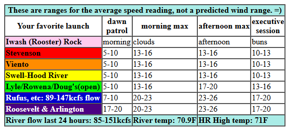
today’s gorge wind forecast
Hi friends! If you’ve been seeking a rest day, know that today’s not it. That’s despite the rain falling in Hood River right now. Next chance for rest in the Gorge wind forecast, meaning under 15mph of wind, is probably going to be Sunday or Monday. That’s when a hot spell takes over and probably turns the wind easterly. But that’s not today…
Wednesday kicked off with pressures of 30.11/30.07/30.01 for gradients of 0.04/0.06. This (along with the rain) indicates you’ll need to head to the eastern Gorge today for best results. Between Stevenson and Mosier, or maybe between Stevenson and The Dalles, westerlies stay under 15mph all day long. Out in the desert, we’ll see a slow build to 23-26mph between Avery and Threemile. Remember that those sensors read high compared to the Swell sensor, meaning that’s probably the equivalent of 18-21mph at Swell. River flow over the last 24 hours was 85-151kcfs (89-147kcfs at Rufus), river temp is 70.9F, and high temp forecast is 71F in Hood River (cloudy all day) and 81F out east (with clouds early and partly cloudy sky later).
RIVER FLOW FOR SITES BETWEEN AVERY (EAST OF THE DALLES) AND RUFUS: CLICK HERE FOR JOHN DAY DAM FLOW.
RIVER FLOW FOR SITES BETWEEN STEVENSON AND DOUG’S BEACH (WEST OF THE DALLES): CLICK HERE FOR THE DALLES DAM FLOW

tomorrow’s gorge wind forecast
On Thursday, a cold front follows Wednesday’s wet warm front. This keeps low clouds on the west side for much of the day. Westerlies start at 13-16mph from Stevenson to Doug’s with 18-22mph from Avery to Arlington. Afternoon westerlies rise to 23-26mph from Mosier to Rufus with 17-20mph at Arlington. The Stevenson-Swell zone is trickier; it depends on what the low clouds do. I suspect we’ll see a period of gusty 20-23mph late morning to early afternoon before another approaching system knocks the Stevenson-Swell zone down to 15-18mph. High temp: 72F for Hood River and 80F with sunshine in the desert.
extended Gorge wind forecast
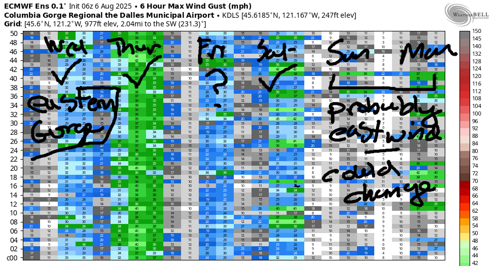
On Friday, we’ll see another round of westerlies as a weather system moves through and is followed by offshore high pressure. Timing will be everything. For now, let’s call it 18-21mph near Swell to start, 15-18mph from Stevenson to Hood River midday, and 18-21mph from Stevenson to Mosier for the executive session after 5pm. High temp: 80F for Hood River. Saturday looks like an interesting one: while the GFS deterministic isn’t calling for much, the setup hints at over-performing wind. If you trust the GFS, we’re only going to see 15-18mph and only from Stevenson to Mosier. I suspect we’ll beat that and see at least low 20s.
Looking at the extended forecast, we see increasing uncertainty but good signs for next week. Sunday and Monday are likely to turn easterly as the hottest weather sets up west of the Cascades. There’s still some uncertainty in the exact amplitude of the heat, so it’s impossible to say how windy it will be. On Tuesday or Wednesday the heat wave collapses, or perhaps it simply starts to fade away. Either way, ensembles bring the westerlies back by Tuesday or Wednesday and keep them around for a while. While there’s still quite a bit of range in the possible outcomes, Wednesday and Thursday currently look like the strongest days next week. That could change. We’ll keep watching it. Have a great day on the river today!
Was that helpful? I knew it was! Guess what? All of this crucial work – from your personal wind and snow reports to the invaluable TATAS updates – is made possible by my relentless efforts. Maintaining this labor of love isn’t easy. Each daily forecast takes hours. Website hosting, weather model access, and back-end admin work takes time and money. That’s where you come in.
YOUR CONTRIBUTION MAKES A DIFFERENCE
- SUPPORT ACCURATE, HYPER-LOCAL WEATHER FORECASTING
- ENABLE ACCESS FOR ALL, EVEN THOSE WITH LESS MEANS
- SUPPORT A COOL HUMAN WHO WORKS HARD SO YOU CAN PLAY
Take a moment to click one of the buttons below. Donate $19.99 or more (how much does this forecast enhance your life?) and get the email in your inbox. Whether it’s a renewing subscription (auto-renew) or a one-time donation, every contribution makes a real difference. Help me keep this labor of love alive, so we can all continue playing, commuting, and living in the Gorge with peace of mind and the best weather forecasts possible. Thank you!


Hood River, Oregon 97031


JONES BEACH, SAUVIE ISLAND, & COAST FORECAST
Wind northerly unless otherwise indicated. For coast, it’s North/Central/South with the “central” at approximately Florence. Swell forecast from NWS for central coast. Jones: westerly unless otherwise stated. Sauvie Island: northerly unless otherwise stated. Coast Wednesday: LTW/LTW?N15, W swell 6′ at 11 seconds. Thursday: NW5-10/N15/N30, W 5′ @ 11. Friday: 20/20/30-35, W 4′ @ 10. Jones Wednesday: LTW. Thursday: 11-14. Friday: 19-22. Sauvie Island Wednesday: LTV. Thursday: 8-11. Friday: 12-15.
BARE BONES HOOD RIVER WEATHER FORECAST
Rain this morning and cloudy later. Temps start near 60 and rise to the low 70s. Light to moderate westerlies. 98% chance of rainbows. Thursday will be partly cloudy then mostly clear. Temps start in the mid 50s and rise to the low 70s. Light westerlies early. Moderately strong later. 1% chance of rainbows. Friday will be mostly clear then clear. Temps start in the low 50s and rise to 80. Moderate westerlies. No rainbows.
TEMIRA’S AWESOME TRAVEL ADVISORY SERVICE
HYPERLOCAL WEATHER FORECAST FOR THE COLUMBIA GORGE
THE DALLES, HOOD RIVER, WHITE SALMON, TROUT LAKE, STEVENSON, CASCADE LOCKS, PARKDALE, ODELL, HUSUM, BZ, MILL A, WILLARD, GOLDENDALE, RUFUS, ARLINGTON, boardman
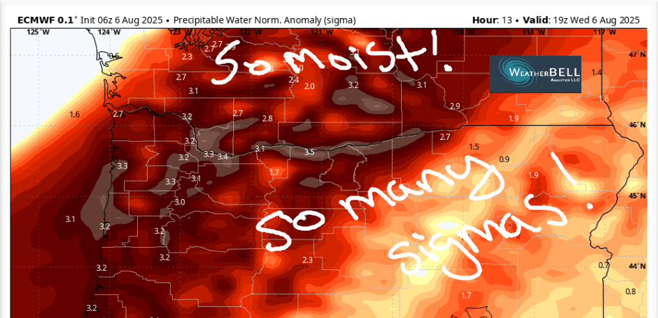
Good morning, neighbors! RAIN!!!! IT’S RAINING!!! This is the best thing to happen since the sliced bread I used for a BLT yesterday. After today, we’ll be back to dry weather, but what a lovely respite this is. Heat is headed our way for the weekend, so enjoy the cool, cloudy, wet weather today. Know what else is cool? We might set a record for available moisture today. The PWAT is in the 3.1-3.5 sigma range. Wow! Moist! Damp! Muggy!
Before I forget… despite the rain, fire danger is still extreme. Now that IFPL has been raised to Level 3, our awesome and generous private landowners have closed their land to public access. That includes (but is not limited to) Underwood Mountain, Hospital Hill (Burdoin Mountain / Kreps land), and the Whoopdee Trail (Hood River Mountain / east ridge). Thank you for respecting the closures. Those lands will be back when fire season is over. Please let that be early this year!
glenwood this morning
Checking in with Glenwood, we find a warm morning: 58 degrees. That might be the warmest morning Glenwood has had this year. Like all Nature-oriented people, the people of Glenwood are out dancing in the rain this morning. Being non-judgmental, they’re in various states of dress and undress. Nothing gets you closer to Nature than a naked dance in the rain, and the people of Glenwood understand this!
today’s gorge weather forecast
For the rest of us… dance naked in the rain if you want! It’s perfectly legal to be naked unless your intent is obscenity, and getting closer to Nature isn’t obscene. It’s healthy. Lots of research supports that! We’ll see drizzle as far east as Celilo Village this morning. Afternoon sees the drizzle mostly stop east of Cascade Locks. It continues there into the evening. Models really kicked up the rain intensity for the western Gorge in the last model run – it might rain hard enough to create puddles and hydroplaning opportunities. Also: roads will be slick today – this is the first rain in a while, and all the goo and oil and blech on the road with combine with the water for a slip-n-slide experience at times. Temps max out near 70 (west), 80 (The Dalles), and low 80s (desert) today. Westerlies climb to 15mph between Stevenson and Mosier and 25mph from Mosier to Threemile Canyon this afternoon.
thursday’s gorge weather forecast
A little drizzle continues west of Cascade Locks into Thursday morning, but the rain ends quickly. We’re left with partly cloudy sky west of Mosier and mostly sunny sky to the east. Westerlies start the day at 10-15mph form Stevenson to Murdoch with 15-20mph from The Dalles to the Arlington Triangle. In the afternoon, the wind rises to 15-20mph west of Mosier and 25mph from Mosier to Rufus with 15-20mph in the Arlington Triangle zone. Temps remain cool: low 70s on the west side, upper 70s in The Dalles , and low 80s in the desert. Expect an excellent night of sleep Thursday into Friday as temps drop into the 50s overnight.
friday’s gorge weather forecast
Friday starts cool as a cucumber (probably one of the 15-20 in my fridge) and finishes pleasant as a pheasant receiving a present. Temps max out near 80 (west) and in the mid to upper 80s from The Dalles into the watermelon growing zones of the desert. Watermelons think upper 80s are cold temps, so they’ll all be wearing jackets. Wind will be 15-20mph out of the west between Stevenson and Mosier.
extended gorge weather forecast
Sunny, increasingly hot weather is forecast for the weekend. On Saturday, temps max out in the 84-91F range. West wind isn’t all that strong in the models, but I’d put money on it actually being rather strong near Hood River. On Sunday and Monday, we’ll have hotter weather (pushing 100 near The Dalles) with (probably) light east wind. The heat wave collapses on Tuesday or Wednesday which sets us up for somewhat cooler, much windier weather for the middle part of next week. After today, there’s no rain in sight through the 20th. So, make the most of today’s rain. What an absolute delight it is! Safe travels. -TATAS
HEY! DON’T STOP READING! Is this community-focused forecast helpful to you? It sure is! It takes me a couple hours a day to write. Please join your friends and neighbors in contributing to keep it going. Venmo: @thegorgeismygym PayPal: twomirrors@gmail.com USPS: Temira / PO Box 841 / Hood River, Oregon 97031 You can test out the forecast subscription for a few days for free by signing up below. Easy! Do it!
