

GORGE WIND FORECAST
today’s gorge wind forecast
Hi friends! Westerlies continue… and now models suggest they won’t completely stop this weekend. The best you’ll get for a rest day, if the ensembles are right, is several days where the max average speed is right around 20mph. That. Is. Not. A. Rest. Day. But don’t worry – there’s still a little space in the Gorge wind forecast for ridging to be stronger than expected and for the wind to stop briefly. Maybe. Probably not. Shall we jump into the details? Yes, let’s!
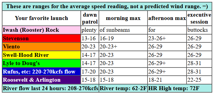
In a fun twist, we finally have a solid marine layer this morning. Clouds persist for much of the day on the west side, and this gives the wind speeds a nudge up. Until mid-morning, the Gorge, like you, will be waking up. We’ll have gusty 17-20ish from Viento to Swell, lighter wind between Hood River and Bingen, and 20-23ish from Mosier to Rufus. Farther east: teens. Late morning sees the wind climb: gusty 19-22 at (cloudy?) Stevenson, 25-28 from Viento to Rufus, and 20-23 at Arlington. Afternoon wind builds to 28-31 from Stevenson to Rufus with 23-26 at Arlington and 17-20 at Threemile. Strong westerlies persist into the Executive Session this evening. River flow over the last 24 hours was 208-270kcfs (220-270 at Rufus), River temp is 62.2F, and high temp forecast is 72F for Hood River and 77F for Arlington.

tomorrow’s gorge wind forecast
High pressure builds on Thursday for a warmer and less windy day. We’ll have 17-20 from Stevenson to Mosier most of the day with 20-23 from Stevenson to Avery for the evening session. Farther east: very little wind at all. In the middle of the day, as the metro area heats, we’re likely to see the wind drop to 14-17 before returning at 17-20 mid afternoon. High temp: 86F for Hood River and 85F for Arlington.
extended Gorge wind forecast
Friday’s wind gets a bit of a nudge up thanks to an intensifying heat low in Central Oregon. For the bulk of the day, we’ll have 21-24 from Stevenson to Hood River. The Lyle-Avery zone joins in the evening. Out in the desert: maybe 10-13mph. High temp: 86F for Hood River and 89F at Arlington.
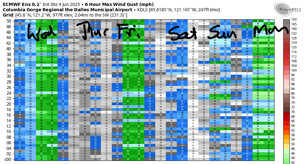
Looking at the Euro ensembles for the weekend, we now have west wind of some sort both days. About 80% of the ensemble members are giving us 17-20mph or better for both days. That’s definitely not a slam dunk forecast, but it’s more optimistic than the last half-dozen model runs (unless you’re looking for a rest day, in which case, that forecast is pessimistic!). Looking out deeper into the forecast, we have models agreeing on a collapse of the weekend heat wave and much cooler weather by the middle of next week. Monday should be westerly, and it might be big. Stars of next week: Tuesday, Wednesday, and Thursday, when the ensembles have three days of very strong west wind. I seriously need a rest day! Hopefully you’ve been playing enough that you’re in the same boat. If not, hopefully you’ll get on the river soon. See you on the Nch’i Wana!
Was that helpful? I knew it was! Guess what? All of this crucial work – from your personal wind and snow reports to the invaluable TATAS updates – is made possible by my relentless efforts. Maintaining this labor of love isn’t easy. Each daily forecast takes hours. Website hosting, weather model access, and back-end admin work takes time and money. That’s where you come in.
YOUR CONTRIBUTION MAKES A DIFFERENCE
- SUPPORT ACCURATE, HYPER-LOCAL WEATHER FORECASTING
- ENABLE ACCESS FOR ALL, EVEN THOSE WITH LESS MEANS
- SUPPORT A COOL HUMAN WHO WORKS HARD SO YOU CAN PLAY
Take a moment to click one of the buttons below. Donate $19.99 or more (how much does this forecast enhance your life?) and get the email in your inbox. Whether it’s a renewing subscription (auto-renew) or a one-time donation, every contribution makes a real difference. Help me keep this labor of love alive, so we can all continue playing, commuting, and living in the Gorge with peace of mind and the best weather forecasts possible. Thank you!


Hood River, Oregon 97031


JONES BEACH, SAUVIE ISLAND, & COAST FORECAST
Wind northerly unless otherwise indicated. For coast, it’s North/Central/South with the “central” at approximately Florence. Swell forecast from NWS for central coast. Jones: westerly unless otherwise stated. Sauvie Island: northerly unless otherwise stated. Wednesday: NW10/N10/N30-35, W swell 3′ at 12 seconds. Thursday: 15-20/20-25/35, W 3′ @ 11. Friday: 15-20/20-25/30-35, NW 6′ @ 9. Jones Wednesday: 7-10. Thursday: 22-25. Friday: 22-25. Sauvie Island Wednesday: NW 7-10. Thursday: 16-19. Friday: 15-18.
BARE BONES HOOD RIVER WEATHER FORECAST
Clouds today with rain from mid-morning on. Temps start in the low 40s and rise to the low 50s. Calm wind. 11% chance of rainbows. Thursday will be showery all day. Temps start in the upper 30s and rise to the upper 40s. Moderate westerlies. 99.99% chance of rainbows. Friday will be High overcast and dry in the morning with rain in the afternoon. Temps start in the low-mid 30s and rise to the mid 40s. Light easterlies. 4% chance of rainbows.
TEMIRA’S AWESOME TRAVEL ADVISORY SERVICE
HYPERLOCAL WEATHER FORECAST FOR THE COLUMBIA GORGE
THE DALLES, HOOD RIVER, WHITE SALMON, TROUT LAKE, STEVENSON, CASCADE LOCKS, PARKDALE, ODELL, HUSUM, BZ, MILL A, WILLARD, GOLDENDALE, RUFUS, ARLINGTON, boardman
Good morning, neighbors! Relatively cool weather today gives way to building heat starting Thursday. We’ll stair-step our way to the upper 90s for Sunday like me and my high school friends doing Step Aerobics. After that, the timing of a cooldown is unclear but the outcome is not: by the middle of next week we’ll be 25 degrees cooler than Sunday. Rain? No, sorry. Despite the massive drop in temps, we’ll remain dry for at least the next 10 days.
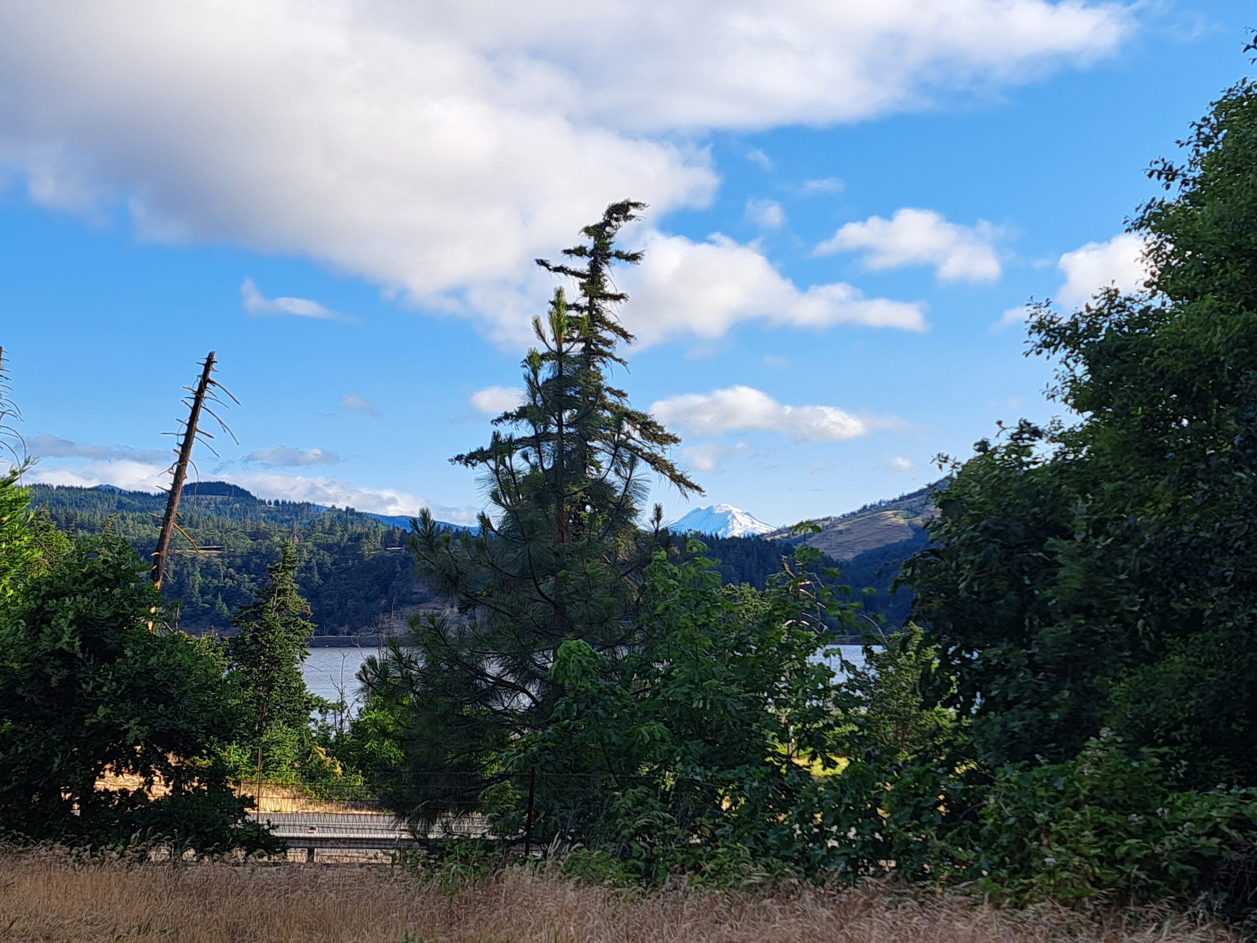
How Glenwood started the day
The only exception to this dryness is a little drizzle this morning west of Cascade Locks, where it’s cloudy. Up in Glenwood, the UP of the Gorge, it’s clear (I think), with a low temp of 38F. Oh Glenwood, you’re such an overachiever. Peeps, if you want to see some cowboys and cowgirls and cowpersons doing their thing, mark your calendar for the Ketchum Kalf Rodeo the weekend of the 15th.
today’s gorge weather forecast
For the rest of us on this lovely Wednesday morning… After an 50-something degree start, we rise to 70 (west) or 77 (east) degrees. Clouds persist west of Hood River for a good part of the day, but the east side will be sunny. Every single one of us eventually ends up with wind: 25-30mph from Stevenson to the Arlington Triangle and 20mph to the east of The Triangle.
thursday’s gorge weather forecast & weekend weather
Hotter weather is on tap for Thursday as a ridge of high pressure sees kinship in all the ridges and hills of the Gorge and settles in for a bit. Temps will be near 50 to start and in the mid 80s to finish. Clouds west of Hood River early Thursday morning quickly burn off. Westerlies will be 15-20mph from Stevenson to Mosier in the morning and 20-25mph from Stevenson to Avery in the afternoon. If you’re east of Avery, you’ll (finally) have a day of light wind. Friday’s weather looks warm (mid-80s), breezy (20-25mph, but only west of Avery), and high cloudy until the evening, when the sky will clear. Hotter weather, 90+ degrees, is in the cards for Saturday and Sunday. Peak heating occurs on Saturday with the potential for 95+ degrees. Hood River’s record high for Sunday is 95 degrees. That record is likely to fall. Depending on what happens on Monday (record: 92), we could set another record. Out in The Dalles, records for this hot period are all over 100 degrees. Those should stand.
next week’s gorge weather forecast
On Monday, or maybe on Tuesday, the heat wave gets bored. Temps start to fall. By the middle of next week, we’ll have highs around 70 degrees or maybe even less. Accompanying the plunging temps: blasting west wind and swarms of boardheads, many of whom are schoolteachers released for the summer. Thanks for teaching the next generation, teachers, and enjoy the summer off! Safe travels. -TATAS
HEY! DON’T STOP READING! Is this community-focused forecast helpful to you? It sure is! It takes me a couple hours a day to write. Please join your friends and neighbors in contributing to keep it going. Venmo: @thegorgeismygym PayPal: twomirrors@gmail.com USPS: Temira / PO Box 841 / Hood River, Oregon 97031 You can test out the forecast subscription for a few days for free by signing up below. Easy! Do it!
