

GORGE WIND FORECAST
today’s gorge wind forecast
Hi friends! Another windy day is on tap. As a matter of fact, we’ll have wind through Friday, and possibly through Saturday, before we (probably) get two not-windy rest days Sunday and Monday. Over the next five days or so, we’ll have much more active weather than recently; this will result in gustier, trickier-to-predict westerlies. But still westerlies!
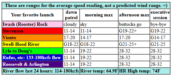
Wednesday started with pressures of 30.06/29.94/29.95 for gradients of 0.12 (pdx-dls) and -0.01 (dls-psc). With clouds forecast to linger on the west side all day, a decent thermal gradient will develop this afternoon: 16 degrees difference between the metro area and Pasco. So… early morning wind will be gusty 19-22 from Swell to the Hatch with 10-13mph pretty much everywhere else. Midday sees the wind build to 19-22 from Viento to Mosier with less than 15mph elsewhere. Afternoon, when the desert heats up, brings 28-32 from Lyle to Arlington. As clouds break up on the west side, areas between Stevenson and Mosier rise to 21-25 average with big gusts and holes. River flow over the last 24 hours was 114-180kcfs, river temp is 64.9F, and high temp forecast is 74F for Hood River and 78F for Arlington.
RIVER FLOW FOR SITES BETWEEN AVERY (EAST OF THE DALLES) AND RUFUS: CLICK HERE FOR JOHN DAY DAM FLOW.
RIVER FLOW FOR SITES BETWEEN STEVENSON AND DOUG’S BEACH (WEST OF THE DALLES): CLICK HERE FOR THE DALLES DAM FLOW

tomorrow’s gorge wind forecast
A brief break in the active weather Thursday, Juneteenth, looks conducive to another windy day. We start with 19-22 from TJ’s Dawn Patrol from Viento to Swell with 11-14 at Stevenson, Hood River and Mosier. Eastern Gorge: light to start. Afternoon wind rises to 27-30 from Mosier to Avery with 22-25 at Rufus and less to the east. Models suggest the Swell zone will have a period of 21-24 before falling to 16-19 due to metro area heating. High temp: 74F for Hood River and 77F for Arlington.
extended Gorge wind forecast
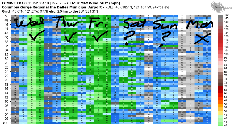
An actual weather system with actual rain is actually forecast for Friday. In terms of wind, the west side clouds will keep the wind going out in the desert. Expect alternating periods of 11-14 and 15-18 west of Lyle. Between Celilo and Boardman, the day starts at 26-29 and rises to 28-32. There’s some indication of the wind backing off in the afternoon. But maybe that forecast will change as we get closer to Friday?
Saturday brings another round of rain to areas west of Mosier. This leaves the western Gorge with 10-15mph or less. Out east, east of Mosier, the current Saturday forecast is 24-27. Quite a bit of range is present in the ensembles for Sunday and Monday, but generally speaking, they’re calling for not-enough wind, perhaps under 15mph. That’s enough for now. Have a great day on the river today!
Was that helpful? I knew it was! Guess what? All of this crucial work – from your personal wind and snow reports to the invaluable TATAS updates – is made possible by my relentless efforts. Maintaining this labor of love isn’t easy. Each daily forecast takes hours. Website hosting, weather model access, and back-end admin work takes time and money. That’s where you come in.
YOUR CONTRIBUTION MAKES A DIFFERENCE
- SUPPORT ACCURATE, HYPER-LOCAL WEATHER FORECASTING
- ENABLE ACCESS FOR ALL, EVEN THOSE WITH LESS MEANS
- SUPPORT A COOL HUMAN WHO WORKS HARD SO YOU CAN PLAY
Take a moment to click one of the buttons below. Donate $19.99 or more (how much does this forecast enhance your life?) and get the email in your inbox. Whether it’s a renewing subscription (auto-renew) or a one-time donation, every contribution makes a real difference. Help me keep this labor of love alive, so we can all continue playing, commuting, and living in the Gorge with peace of mind and the best weather forecasts possible. Thank you!


Hood River, Oregon 97031


JONES BEACH, SAUVIE ISLAND, & COAST FORECAST
Wind northerly unless otherwise indicated. For coast, it’s North/Central/South with the “central” at approximately Florence. Swell forecast from NWS for central coast. Jones: westerly unless otherwise stated. Sauvie Island: northerly unless otherwise stated. Wednesday: LTNW/LTNW/N25-30, W swell 4′ at 12 seconds. Thursday: NW10/NNW10/N25-30, W 6′ @ 12. Friday: W10/W10-15/LTS, W 5′ @ 11. Jones Wednesday: 11-14. Thursday: 20-23. Friday: 8-12. Sauvie Island Wednesday: 16-19. Thursday: 15-18 > 5pm. Friday: LTV.
BARE BONES HOOD RIVER WEATHER FORECAST
Partly cloudy sky this morning turns mostly clear later. Temps start in the low 60s and rise to the mid 70s. Light westerlies early. Moderately strong later. No rainbows. Thursday will be partly cloudy then high overcast. Temps start in the upper 40s and rise to the mid 70s. Moderate westerlies. No rainbows. Friday will be cloudy with drizzle or showers possible then partly cloudy in the afternoon. Temps start near 50 and rise to the low 60s. Moderate westerlies. 79% chance of rainbows.
TEMIRA’S AWESOME TRAVEL ADVISORY SERVICE
HYPERLOCAL WEATHER FORECAST FOR THE COLUMBIA GORGE
THE DALLES, HOOD RIVER, WHITE SALMON, TROUT LAKE, STEVENSON, CASCADE LOCKS, PARKDALE, ODELL, HUSUM, BZ, MILL A, WILLARD, GOLDENDALE, RUFUS, ARLINGTON, boardman
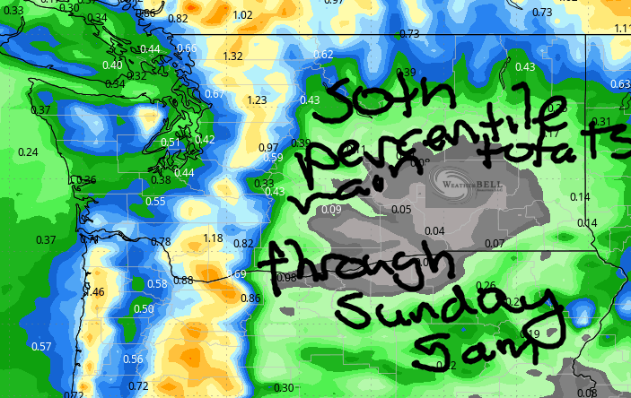
Good morning, neighbors! Something different this way comes! But until it does, it’s more of the same: a couple more (mostly) dry, pleasant, breezy days in the Gorge. Starting Friday, rain is in the picture for at least some of us. The bulk of this rain falls between Friday morning and Sunday morning, and the bulk of it falls west of Hood River, but… we could still see measurable rain between Hood River and The Dalles which is great for those concerned about fire danger and not great for those concerned about their cherry crop.
glenwood this morning!
Before we get into the details of rain chances, let’s say hi to Glenwood. Hi, Glenwood. When I looked this morning (after about 9.5 hours of sleep), Glenwood’s temp was 58 degrees, right around the same temp as the rest of us. WE’RE ALL IN THIS TOGETHER!
today’s gorge weather forecast
Afternoon temps rise to the mid 70s (west), upper 70s (The Dalles), and upper 80s (watermelon zones out by Hermiston). A little drizzle and lots of clouds west of Hood River this morning give way to partly cloudy sky. East of Hood River: clear and sunny all day long. Westerlies pick up this afternoon: 20-25mph from Stevenson to Mosier with 30-35mph from Lyle to Threemile Canyon and beyond.
juneteenth gorge weather forecast
In TATAS’ opinion, Thursday will be PERFECT. After a cool and zzz-friendly start (45-50 degrees), temps rise to 74 (west) and 81 (far east). After a partly cloudy (west) and clear (east) start, high clouds arrive for all of us. Pretty sunset potential is about 92%. West wind will be 15-20 in the morning west of Rowena and 10-15 east of Rowena. Afternoon wind rises to 20-25 from Stevenson to Hood River with 25-30mph from Mosier to Avery, 20-25 near Biggs, and 15-20mph at the Arlington Triangle.
friday gorge weather forecast
The Something Different comes this way on Friday in the form of a cold front attached to an offshore low pressure system. PWAT (available moisture) rises to 0.7-0.9”, which works out to about 135% of normal. TATAS loves numbers. Massive moisture, that’s not. But it should be enough for rain west of Underwood and intermittent drizzle to Hood River and potentially Mosier and The Dalles on-and-off through Saturday afternoon. Thanks to the cool air aloft and warm air at the surface, instability makes a showing on Friday afternoon. Thunderstorms: slight chance. Downpours: medium chance. Wind on Friday will be 10-20mph west of Lyle, 20-25mph between Lyle and Avery, and 25-30mph from Celilo to Boardman. Friday’s high temp will only be in the low 60s (west) and low 70s (far east).
extended gorge weather forecast
Actual steady rain falls west of Hood River on Saturday with showers possible to Hood River and maybe Mosier. Temps max out at 59-63, quite chilly for this time of year. Wind will be 10-15mph west of The Dalles and 20-30mph east of The Dalles. Dry, cool, not windy weather is forecast Sunday and Monday. This results in most people being happy. Most people will be jumping for joy at the lack of wind and leaving their houses and playing golf and fishing and doing whatever not-Boardheads do when it’s not-windy. Boardheads will be sad. Bored, even!
Beyond the weekend, models suggest a sharp rise in temps for the middle of next week (low 90s, maybe) followed by a sharp cooldown at the end of next week. The only reasonable approach to the wild temps swings is to decide you’re okay with whatever temp happens. It’s not like you, I, NWS, or anyone else can do anything about the day-to-day high temp. Might as well be cool with it. And while you’re working with that homework, go out and do something nice for someone today. And pay it forward if someone does and act of kindness towards you. Remember when we could pay for the bridge toll for the person behind us? Ah, those were the days. I miss doing that. Safe travels. -TATAS
HEY! DON’T STOP READING! Is this community-focused forecast helpful to you? It sure is! It takes me a couple hours a day to write. Please join your friends and neighbors in contributing to keep it going. Venmo: @thegorgeismygym PayPal: twomirrors@gmail.com USPS: Temira / PO Box 841 / Hood River, Oregon 97031 You can test out the forecast subscription for a few days for free by signing up below. Easy! Do it!
