

GORGE WIND FORECAST
If you’re still seeing yesterday’s and it’s after 9am, try opening this in an incognito window
today’s gorge wind forecast
Hi friends! Today is our last best chance for west wind for a while. Next chance, at the very earliest, is Sunday, but it’s likely going to be farther out in the future than that. We will see a day or two of marginal easterlies in this upcoming heat wave, but mostly we’re in for some rest days, at least rest days from wind sports! When will the cooldown and associated (potentially) big days happen? There’s so much uncertainty in the models that I can’t pinpoint anything yet. Given the east wind forecast and the heat coming, I’m going to do the forecast in the evening for a few days – that’ll allow me to reclaim a couple hours in the cool mornings to get some exercise. We’ll be back to our normal morning forecast when the heat breaks!
It’s windy this morning. It’s Wednesday, and we started with pressures of 30.23/30.14/30.11 as a trough moves across the PNW. That gave us 7am gradients of 0.09/0.03. Westerlies were 19-22mph from Viento to Swell to start the day with 15-18mph near Rowena and Rufus. Stevenson started at 12-15mph, and so did Arlington. The Viento to Mosier zone holds at 19-22mph this morning. Stevenson eventually joins in. Models suggest the Stevenson-Hood River zone will drop to 16-19mph this afternoon thanks to clear sky in Portland. Shift yourself east to Mosier-Avery for 19-22mph. Rufus joins late afternoon, and Arlington builds to 16-19mph this evening. River flow over the last 24 hours was 85-180kcfs, river temp is 72.1F (poor salmon), and high temp forecast is 82F for Hood River with clearing sky.
RIVER FLOW FOR SITES BETWEEN AVERY (EAST OF THE DALLES) AND RUFUS: CLICK HERE FOR JOHN DAY DAM FLOW.
RIVER FLOW FOR SITES BETWEEN STEVENSON AND DOUG’S BEACH (WEST OF THE DALLES): CLICK HERE FOR THE DALLES DAM FLOW

tomorrow’s gorge wind forecast
Thursday sees a ridge of high pressure build over the region and a heat low settle on the west side. Models suggest light easterlies, peaking at 15mph midday. That said, there’s some indication of a light onshore thermal gradient between the metro area and Hood River, so light west wind isn’t completely out of the picture. Either way, the wind is almost certain to be too light for wind sports. High temp: 90F for Hood River with clear sky.
extended Gorge wind forecast
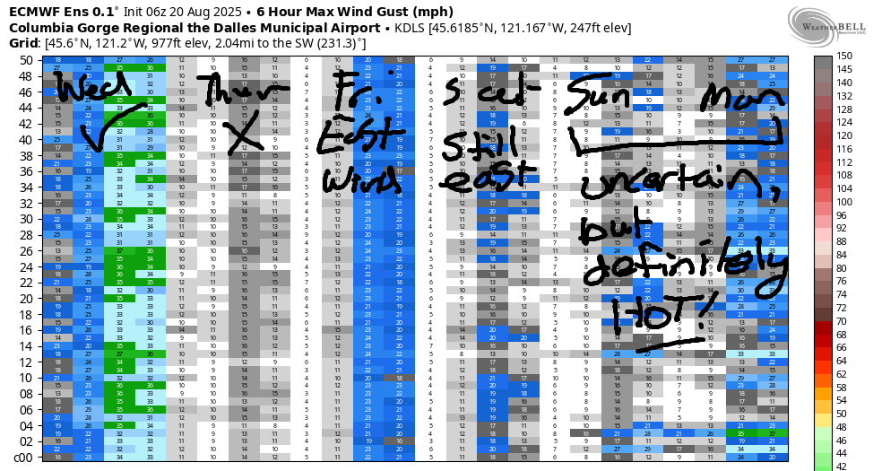
Stronger east wind is forecast on Friday as a robust heat low settles in on the west side. Expect peak wind in the morning prior to peak heating in the Gorge. 25mph at Iwash (Rooster) Rock, 20mph at Stevenson, and 15mph at Home Valley and Viento. Easterlies rise to 10mph from Swell eastward in the afternoon, and drop to 10-15mph at Rooster, Stevenson, etc. High temp: 99F. HOT!
Looking at the extended forecast, what’s most prominent is the struggle of the models to agree on the timing of a cooldown. For now, we have light east wind on Saturday. Starting Sunday, uncertainty rises. We could see light westerlies late in the day, or they could hold off. Even more confusion exists to start next week: the GFS deterministic tosses the heat to the east and returns the westerlies on Monday. The Euro does not agree – it’s all over the place on cooling. By the end of next week, we’ll be back to westerlies. So say the ensembles. I’ll be gone for six days or so on a retreat starting next Saturday, so you’ll be left to your own devices. In the meantime, I’ll see you on the Nch’i Wana!
Was that helpful? I knew it was! Guess what? All of this crucial work – from your personal wind and snow reports to the invaluable TATAS updates – is made possible by my relentless efforts. Maintaining this labor of love isn’t easy. Each daily forecast takes hours. Website hosting, weather model access, and back-end admin work takes time and money. That’s where you come in.
YOUR CONTRIBUTION MAKES A DIFFERENCE
- SUPPORT ACCURATE, HYPER-LOCAL WEATHER FORECASTING
- ENABLE ACCESS FOR ALL, EVEN THOSE WITH LESS MEANS
- SUPPORT A COOL HUMAN WHO WORKS HARD SO YOU CAN PLAY
Take a moment to click one of the buttons below. Donate $19.99 or more (how much does this forecast enhance your life?) and get the email in your inbox. Whether it’s a renewing subscription (auto-renew) or a one-time donation, every contribution makes a real difference. Help me keep this labor of love alive, so we can all continue playing, commuting, and living in the Gorge with peace of mind and the best weather forecasts possible. Thank you!


Hood River, Oregon 97031


JONES BEACH, SAUVIE ISLAND, & COAST FORECAST
Wind northerly unless otherwise indicated. For coast, it’s North/Central/South with the “central” at approximately Florence. Swell forecast from NWS for central coast. Jones: westerly unless otherwise stated. Sauvie Island: northerly unless otherwise stated. Coast Wednesday: 20/20-25/30, waves NW 3′ at 9 seconds. Thursday: 20-25/20-25/30, SW 2′ @ 15. Friday: 20-25/10-15/25-30, SW 2′ @ 14. South coast stays windy through next Tuesday or Wednesday, probably. Rest of the coast looks marginal. You know, just in case you want to escape the heat! Jones Wednesday: 12-15. Thursday: calm. Friday: LTW. Sauvie Island Wednesday: 8-11. Thursday: 114-17. Friday: 13-16.
BARE BONES HOOD RIVER WEATHER FORECAST
Partly cloudy sky this morning (and a pretty sunrise) turns clear this afternoon. Temps start in the mid 60s and rise to the low 80s. Moderate westerlies. No rainbows. Thursday will be sunny. Temps start in the mid 50s and rise to 90 or so. Calm wind then light easterlies. No rainbows. Friday will be sunny. Temps start near 60 and rise to the mid 90s. Light to moderate easterlies. No rainbows. Heat continues for a while…
TEMIRA’S AWESOME TRAVEL ADVISORY SERVICE
HYPERLOCAL WEATHER FORECAST FOR THE COLUMBIA GORGE
THE DALLES, HOOD RIVER, WHITE SALMON, TROUT LAKE, STEVENSON, CASCADE LOCKS, PARKDALE, ODELL, HUSUM, BZ, MILL A, WILLARD, GOLDENDALE, RUFUS, ARLINGTON, boardman
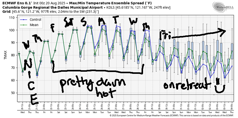
Good morning, neighbors! Hot weather is on tap. When we first looked at this heat wave, it was only going to last a couple days. Models have shifted, and the heat (which I call 90+ degrees for Hood River) looks to continue for longer. How long? Not sure yet! In a fun twist, there’s now some indication of thunderstorms (and mugginess) for the Monday-Wednesday time period along with the heat, assuming monsoonal moisture can make it far enough north. Temps eventually cool down by the end of next week, when I’ll be leaving for a retreat, so it’ll be nice if it’s cool!
GLENWOOD THIS MORNING
It’s Wednesday, so let’s check in with Glenwood. Chilly there this morning: 43 degrees. I’m seriously tempted to move there for this upcoming heat wave!
TODAY’S GORGE WEATHER FORECAST
For the rest of us today… a trough (cooler air with a little oomph) moving through the region started us with some clouds. We’ll clear up this afternoon. Only a few mid-level clouds will linger. West wind picks up to 20mph from Stevenson to Mosier this morning and spreads all the way east to the Arlington Triangle this evening. Highs range from 82F (west) to 87F (The Dalles) and 90F (watermelon-growing areas). Overnight: clear sky.
THURSDAY’S GORGE WEATHER FORECAST
Clear sky, light wind, and relatively low relative humidity sets us up for a cool start on Thursday. It won’t stay cool. Temps rise to 90F (west), 95F (The Dalles), and 92F (desert). Also hot Thursday: the Valley of Willies (Willamette Valley), which turns Gorge wind easterly (probably): 10-15mph at Iwash (dick) Rock and the zone between Stevenson and Viento. Near Hood River: mostly calm, which gives me a chance to spray fungicide. To the east: 5-10mph wind.
EXTENDED GORGE WEATHER FORECAST
Friday looks hot and sunny. After a 60(ish) degree start, temps rise to 94-99F degrees. Waaaaaah. Too hot for TATAS! East wind peaks mid-morning at 25mph (Dick Rock), 20mph (Stevenson), and 10-15mph to the east. The wind lingers into the evening at 10mph pretty much everywhere. Saturday and Sunday both look hot: upper 90s on the west side, 100-105F for The Dalles, and 100F in the desert. The wind is almost certain to be light on Saturday. At some point, the heat low will shift east of the Cascades. We’ll slowly cool, and the west wind will return. That could be as early as Monday, or it could be later next week. Either way, prepare for a stretch of hot weather.
On top of the heat, there’s the potential for mugginess starting early next week. With the mugginess comes the potential (slight, so far) for thunderstorms. The Euro ensemble’s pretty excited about instability for the Monday-Wednesday time period, but I’m being skeptical for now. So far our BIG THUNDERSTORM POTENTIAL hasn’t worked out this year. Maybe this time? Maybe we’ll get some rain? That would be awesome. Safe travels. -TATAS
HEY! DON’T STOP READING! Is this community-focused forecast helpful to you? It sure is! It takes me a couple hours a day to write. Please join your friends and neighbors in contributing to keep it going. Venmo: @thegorgeismygym PayPal: twomirrors@gmail.com USPS: Temira / PO Box 841 / Hood River, Oregon 97031 You can test out the forecast subscription for a few days for free by signing up below. Easy! Do it!
