

GORGE WIND FORECAST
today’s gorge wind forecast
Hi friends! Wow, The Wall and Rufus exceeded yesterday’s already strong forecast with a nearly 40mph showing for a few hours. We’ll have another strong showing out there this afternoon. Somewhat lesser wind is in the cards for Thursday. Want a rest day? Friday is your day. We’re back to moderately strong westerlies for Saturday. Ensembles continue with nuker optimism for Sunday, potentially near Hood River, and strong wind is likely again on Monday, again in the Corridor. Heck yeah! Beyond that, we fall into a more active and less hopeful pattern, but you might be wanting some relief from wind sports by then!
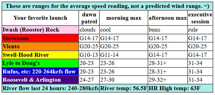
Let’s look at Wednesday: pressures were 30.14/30.05/29.95 to start the day for 0.09/0.10. Offshore high pressure was 30.35inhg. Elevated wind is forecast to be WNW 25kts today, lesser support than yesterday, but still good. Clouds are forecast to stick around for the west side all day, so you’ll be driving east of Hood River for best results. Dawn Patrol wind was quite up and down with most locations in the upper teens to mid 20s. We’re going to see a slow, steady build today with strong wind after 1pm. West of Mosier, or maybe even west of Doug’s, you’ll have gusty 15-18 all day. By late morning, we’ll have 24-27 from Avery to Threemile. 2pm: 28-31. After 2pm: 31-35 (+) from Avery to Threemile. Boardman joins in late with 23-26. River flow over the last 24 hours was 240-280kcfs (220-264 at Rufus, where reports have “strong current, big swell, chaotic” conditions). Max for decent conditions (meaning swell, not washed out) is somewhere around 300-325kcfs. High temp forecast is 61F for Hood River and 65F with sunshine for Arlington.

tomorrow’s gorge wind forecast
Quite a few moving parts combine on Thursday for a somewhat lesser day. But don’t you worry – it’ll still be windy. Opening play is 15-18 from Viento to Arlington with less at Stevenson. By late morning, westerlies rise to 20-23 from Stevenson to Doug’s with 17-20 at Avery and 14-17 at Rufus. Afternoon wind climbs to 23-26 from Mosier to Rufus with gusty 16-20 from Stevenson to Hood River and 17-20 at Arlington. Add a few mph for the Executive Session between Avery and Threemile for 25-28. High temp: 61F for Hood River and 64F for Arlington.
extended Gorge wind forecast
Relief in the form of a rest day is on tap for Friday. Maybe. Depends on your threshold. As of this morning, wind speeds on Friday look to be in the 14-17mph range. High temp: 66F and partly cloudy.
Now, let’s look at Victoria Day weekend. If I were Canadian and felt comfortable coming to the US, I’d come down. Saturday’s the least of the days and currently has a forecast of 23-26. Sunday: strong to nuking westerlies likely all the way from Swell to Rufus and perhaps beyond. Monday: also strong, and likely focused in the Corridor (near Hood River). A lesser, but still windy day is in the cards for Tuesday. Beyond that, model uncertainty rises and the chance of strong wind plummets. Get on it this weekend if you can. See you on the Nch’i Wana!
Was that helpful? I knew it was! Guess what? All of this crucial work – from your personal wind and snow reports to the invaluable TATAS updates – is made possible by my relentless efforts. Maintaining this labor of love isn’t easy. Each daily forecast takes hours. Website hosting, weather model access, and back-end admin work takes time and money. That’s where you come in.
YOUR CONTRIBUTION MAKES A DIFFERENCE
- SUPPORT ACCURATE, HYPER-LOCAL WEATHER FORECASTING
- ENABLE ACCESS FOR ALL, EVEN THOSE WITH LESS MEANS
- SUPPORT A COOL HUMAN WHO WORKS HARD SO YOU CAN PLAY
Take a moment to click one of the buttons below. Donate $19.99 or more (how much does this forecast enhance your life?) and get the email in your inbox. Whether it’s a renewing subscription (auto-renew) or a one-time donation, every contribution makes a real difference. Help me keep this labor of love alive, so we can all continue playing, commuting, and living in the Gorge with peace of mind and the best weather forecasts possible. Thank you!


Hood River, Oregon 97031


JONES BEACH, SAUVIE ISLAND, & COAST FORECAST
Wind northerly unless otherwise indicated. For coast, it’s North/Central/South with the “central” at approximately Florence. Swell forecast from NWS for central coast. Jones: westerly unless otherwise stated. Sauvie Island: northerly unless otherwise stated. Wednesday: NW5-10/NW10/N25, NW swell 7′ at 10 seconds. Thursday: LTV/LTNW/N25-30, NW 5′ @ 11. Friday: TLW/LTW/N10-15, W 6′ @ 11. Jones Wednesday-Friday: LTW. Sauvie Island Wednesday: 7-10. Thursday: 10-13. Friday: LTV.
BARE BONES HOOD RIVER WEATHER FORECAST
Clouds and drizzle this morning with mostly cloudy sky later. Temps start in the low 50s and rise to the low 60s. Moderate westerlies. 89% chance of rainbows. Thursday will be cloudy. Temps start in the low 40s and rise to the low 60s. Moderate westerlies. 1% chance of rainbows. Friday will be cloudy then partly cloudy. Temps start in the mid 40s and rise to the mid 60s. Light westerlies. No rainbows.
TEMIRA’S AWESOME TRAVEL ADVISORY SERVICE
HYPERLOCAL WEATHER FORECAST FOR THE COLUMBIA GORGE
THE DALLES, HOOD RIVER, WHITE SALMON, TROUT LAKE, STEVENSON, CASCADE LOCKS, PARKDALE, ODELL, HUSUM, BZ, MILL A, WILLARD, GOLDENDALE, RUFUS, ARLINGTON, boardman

Good morning, neighbors! It’s Wednesday, 5/14! Spring is being very spring-like, other than the lack of rain. Let’s be grateful for the cool temps and cloud cover protecting our limited soil moisture, shall we? While a bit of drizzle is forecast here and there (mostly on the west side) for the next few days, and there’s a shot at more widespread rain on Saturday, there’s really very little sign of significant falling moisture in the next couple of weeks. Fortunately, there’s also very little sign of super-hot weather, although temps should warm up near normal (upper 60s) or a bit above starting next Wednesday.
TODAY’S GORGE WEATHER FORECAST AND GLENWOOD’S START
This Wednesday, however, does not look hot. Unless you’re looking at me. I’m hot. No, really, I’m having a hot flash right now, so I’m hot. Back to the outdoor temps: most of us started in a similar vein to Glenwood, which started today at 48 degrees. Intermittent drizzle is possible as far east as Hood River until 11am and as far east as Cascade Locks early afternoon. After that: we all shall be dry. Dry as my twat was before I started HRT. Now it’s not dry, but it’s bored. Clouds stick around west of Mosier or perhaps The Dalles today. East of The Dalles, the sky turns mostly clear, and the river fills with the colorful sails, kites, and jerseys of The Wind Johnnies. Wind: 15-20mph west of Lyle (or maybe The Dalles) and 30+ mph east of The Dalles. Fun fact: westerlies maxed out at 35-40mph yesterday near Amayah’s (the location formerly known as Biggs). Fortunately, this did not blow Amayah’s away. Fantastic Indian food is still there for you to enjoy. Temps today max out in the low to mid 60s.
thursday’s gorge weather forecast
Mostly cloudy sky sticks around all day Thursday as an offshore system pushes high clouds across the PNW. Morning temps will be in the low 40s, and afternoon highs rise to 60ish degrees. Early in the evening, a bit of rain falls west of Wyeth and also in South Wasco county. TATAS recommends you strip naked and dance in the rain. This will surely encourage more of it, and if it doesn’t, it will create joy in your heart and make the world a better place. Westerlies will be 15-20mph from Stevenson to Hood River with 20-30mph (strongest late) east of Hood River all the way out to Threemile Canyon in the evening.
…and friday…
A cloudy start to Friday gives way to a partly cloudy afternoon. Temps rise from the mid 40s to the mid 60s along with west wind at 10-15mph.
victoria day weekend weather forecast
Plan for a Canuck-filled, super windy Victoria Day weekend. Some rain is possible on Saturday, but we’ll be lucky if we pick up 0.10”, which is the amount of rain needed to tamp down the dust on the trails. I can’t remember if NWS defines “soaking rain” as 0.10” or 0.25”, and my limited search engine use this morning didn’t help. Wait, I’ll ask Claude. Stand by. Oh, it turns out there is no NWS definition for that term – it merely means that rainfall occurs over a long enough period of time to penetrate and saturate the soil rather than running off. It’s like the good sex of rainfall – long-lasting enough that everyone benefits. We’re unlikely to have enough rain for long enough on Saturday to qualify. Hopefully your sex life (unless you’re Ace), is more fulfilling than the rainfall. Other guidance for the weekend: temps will be in the low 60s, west wind will be quite strong (and “nuking”, defined as averaging 30+mph, on Sunday) through Monday, and um, I can’t think of a third thing. Oh, it’ll be good weather for planting seeds and germinating them. Safe travels. -TATAS
HEY! DON’T STOP READING! Is this community-focused forecast helpful to you? It sure is! It takes me a couple hours a day to write. Please join your friends and neighbors in contributing to keep it going. Venmo: @thegorgeismygym PayPal: twomirrors@gmail.com USPS: Temira / PO Box 841 / Hood River, Oregon 97031 You can test out the forecast subscription for a few days for free by signing up below. Easy! Do it!
