

GORGE WIND FORECAST
today’s gorge wind forecast
Hi friends! It’s Wednesday, and for many of us, it’s the day we’ve been waiting for. Massive gradients this morning lead to strong wind pretty much all day long. Westerlies persist in the Gorge wind forecast at least through Friday and probably through the weekend, with Sunday looking stronger than Saturday thanks to a nice push of cool air on the west side. For those of you with a 17-20mph minimum, there’s no rest in sight!
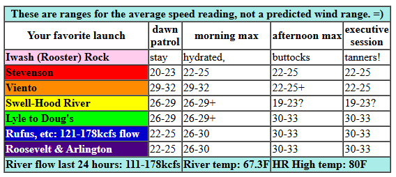
Wednesday kicked off with a “yee-haw” from Dave Brown in response to this pressure report: 29.99/29.80/29.72 for gradients of 0.19 (PDX-DLS) and 0.08 (DLS-PSC). This report screams “Hatch to Rufus and maybe beyond”. It’ll be nice to have the holiday week crowds spread across the Gorge, eh? Remember that this forecast is for the readings on the iWind/iKite sensors, and that Swell reads low compared to most of the others… Expect 26-29 at Swell (30ish at Viento) for TJ’s Dawn Patrol with 20-23 at Stevenson and the slow-to-respond Rowena section of the river. From Avery to Arlington, the day starts with 23-26. Mid-morning wind holds or even rises to 29-32 from Viento to Swell and fills in to Mosier with building wind out east.
For the afternoon, westerlies rise to 30-33 from Mosier to Arlington with a shot at 32-35 between Rowena and Rufus. Threemile joins in at 27-30ish, which results in Erin and Jeff driving out there. Given that we’re probably going to lose the metro area clouds, we’re likely to see Swell-Hood River drop to gusty 19-23 this afternoon (although it could hold if the metro area marine clouds hold) while Stevenson and Viento hold at 22-25+. To summarize: windiest at Swell early this morning and from Avery to Threemile this afternoon. River flow over the last 24 hours was 111-170kcfs (121-178kcfs at Rufus), river temp is 67.3F, and high temp forecast is 80F for Hood River and 89F for Arlington with low humidity. Stay hydrated, folks!
RIVER FLOW FOR SITES BETWEEN AVERY (EAST OF THE DALLES) AND RUFUS: CLICK HERE FOR JOHN DAY DAM FLOW.
RIVER FLOW FOR SITES BETWEEN STEVENSON AND DOUG’S BEACH (WEST OF THE DALLES): CLICK HERE FOR THE DALLES DAM FLOW

tomorrow’s gorge wind forecast
A bit less thermal support on Thursday leads to somewhat lesser wind. Models do suggest marine clouds on the west side, so we could beat the models. TJ’s Dawn Patrol starts with 19-22 from Viento to Hood River. We’ll see a quick jump mid-morning to 21-24 from Stevenson to Mosier with 13-16 for the Rowena and Avery areas. Afternoon wind drops to 17-20 from Swell to Hood River, holds at 21-24 from Stevenson to Viento, and rises to 21-24 from Mosier to Avery. Evening wind builds to 23-26 between Lyle and Arlington with less to the east and gusty 17-20 from Stevenson to Mosier. High temp: 79F for Hood River and 84F for Arlington.
extended Gorge wind forecast
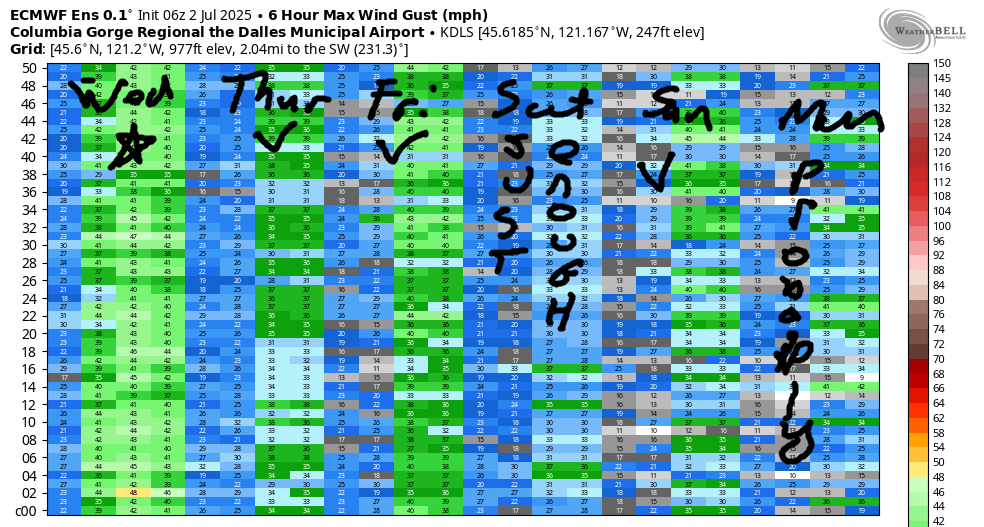
A weak weather system swings through on Friday, which will probably knock down the wind quality. While models are quite optimistic about wind speeds, the wind usually under-performs with this particular setup. Dawn Patrol, thanks to early-morning stability in the atmosphere, looks like 22-25 from Viento to Avery. Models suggest an afternoon build to the mid-upper 20s near Doug’s while the Swell/Hood River area drops to 17-20ish. If we do so those stronger Near East (Lyle to Avery) wind speeds, the wind will be quite up-and-down. I suspect we’re more likely to see low-mid 20s. We’ll look closer as we get closer to Friday. For now, let’s just say “it’ll be windy enough” and leave it there!
Moving on to the weekend… Thanks to somewhat warmer weather, Saturday looks somewhat lighter. As of this morning, I’m guessing we’ll see 19-22mph from Stevenson to Mosier. A decent push of cooler air on the west side is (probably) in the cards for Sunday; that results (probably) in stronger westerlies. Monday’s questionable with a lot of range in both the temp forecast and the wind forecast. It’s a solid “maybe” at this point. Beyond that, uncertainty increases (as does heat next week, probably), so I’ll leave it here for now. See you on the Nch’i Wana!
Was that helpful? I knew it was! Guess what? All of this crucial work – from your personal wind and snow reports to the invaluable TATAS updates – is made possible by my relentless efforts. Maintaining this labor of love isn’t easy. Each daily forecast takes hours. Website hosting, weather model access, and back-end admin work takes time and money. That’s where you come in.
YOUR CONTRIBUTION MAKES A DIFFERENCE
- SUPPORT ACCURATE, HYPER-LOCAL WEATHER FORECASTING
- ENABLE ACCESS FOR ALL, EVEN THOSE WITH LESS MEANS
- SUPPORT A COOL HUMAN WHO WORKS HARD SO YOU CAN PLAY
Take a moment to click one of the buttons below. Donate $19.99 or more (how much does this forecast enhance your life?) and get the email in your inbox. Whether it’s a renewing subscription (auto-renew) or a one-time donation, every contribution makes a real difference. Help me keep this labor of love alive, so we can all continue playing, commuting, and living in the Gorge with peace of mind and the best weather forecasts possible. Thank you!


Hood River, Oregon 97031


JONES BEACH, SAUVIE ISLAND, & COAST FORECAST
Wind northerly unless otherwise indicated. For coast, it’s North/Central/South with the “central” at approximately Florence. Swell forecast from NWS for central coast. Jones: westerly unless otherwise stated. Sauvie Island: northerly unless otherwise stated. Wednesday: LTNW/NW10/N30-35, N swell 4′ at 8 seconds. Thursday: 15-20/15/20-25, N 3′ @ 5. Friday: NW5-10/NW5-10/N20, N 3′ @ 5. Jones Wednesday: 10-13. Thursday: 19-22. Friday: 20-23. Sauvie Island Wednesday: 16-19. Thursday: 14-17 > 5pm. Friday: 12-15.
BARE BONES HOOD RIVER WEATHER FORECAST
Mostly clear sky this morning turns clear. Temps start in the low 60s (open windows and doors) and finish around 80 (close the house up). Strong westerlies. No rainbows. Thursday will be partly cloudy then clear. Temps start in the upper 50s and rise to the upper 70s. Moderate westerlies. No rainbows. Friday will be high overcast then partly cloudy. Temps start in the mid 50s and rise to the mid-upper 70s. Moderately strong westerlies. No rainbows.
TEMIRA’S AWESOME TRAVEL ADVISORY SERVICE – WEDNESDAY 7/2
HYPERLOCAL WEATHER FORECAST FOR THE COLUMBIA GORGE
THE DALLES, HOOD RIVER, WHITE SALMON, TROUT LAKE, STEVENSON, CASCADE LOCKS, PARKDALE, ODELL, HUSUM, BZ, MILL A, WILLARD, GOLDENDALE, RUFUS, ARLINGTON, boardman
Good morning, neighbors! If you were waiting for the heat to dissipate, you’re in luck – temps today will be down about 10 degrees from yesterday for most of us. Along with the cooler weather comes strong wind, super-high fire danger, and overexcited Boardheads zipping around chasing the big waves. Speaking of… today will be a great day for watching windsports at the Spring Creek Fish Hatchery (morning) or Rufus/The Wall/Arlington/Doug’s Beach this afternoon – the river waves should be massive, almost as big as the smiles on the faces of the Wind Johnnies.
GLENWOOD’S START AND TODAY’S GORGE WEATHER FORECAST
Before I get too excited about the weather, let’s say hi to our friends in Glenwood. What a perfect morning it is there for opening the windows and doors and having a cup of strong coffee on the porch: 54 degrees. The rest of us started in the 58 (west) to 71 (east) degree range. Looks like the cooler air hasn’t pushed all the way into the desert yet, eh? Temps today rise to 80 (west), 87 (The Dalles) and 96 (way out east where the watermelons grow). On to today’s wind, which is deeply concerning given how dry it is out there: we’ll have westerlies at 30mph all pretty much all day everywhere along the river between Stevenson and the Arlington Triangle and out towards Boardman.
NWS Pendleton issued a Red Flag Warning for extreme fire danger. No fucking around today, people (and train companies and power companies, please). Any fires that start will have explosive growth. Sometimes fires can start in unexpected ways: mowing, weed whacking, tossing cigarette butts (duh), fireworks (duh), dragging trailer chains… Please be careful out there today and for the love of the Gorge, respect the fireworks bans. Finishing on a positive note… for many of us, temps will be cool enough at bedtime to sleep with the windows open and the fresh air infiltrating the house like a big dog infiltrating your bed as soon as he/she/they thinks you’re asleep and won’t notice.
THURSDAY’S GORGE WEATHER FORECAST
Moving on to Thursday: we’ll have a nice cool start thanks to all this onshore wind dragging in less-actitve air molecules from the west side. Expect upper 50s on Thursday morning with 79-89 degrees in the afternoon. West wind starts at 19-22 west of Mosier and 15mph or less to the east. Afternoon: 20-25mph from Mosier to Avery with 15-20mph east of Avery to the Arlington Triangle.
extended gorge weather forecast
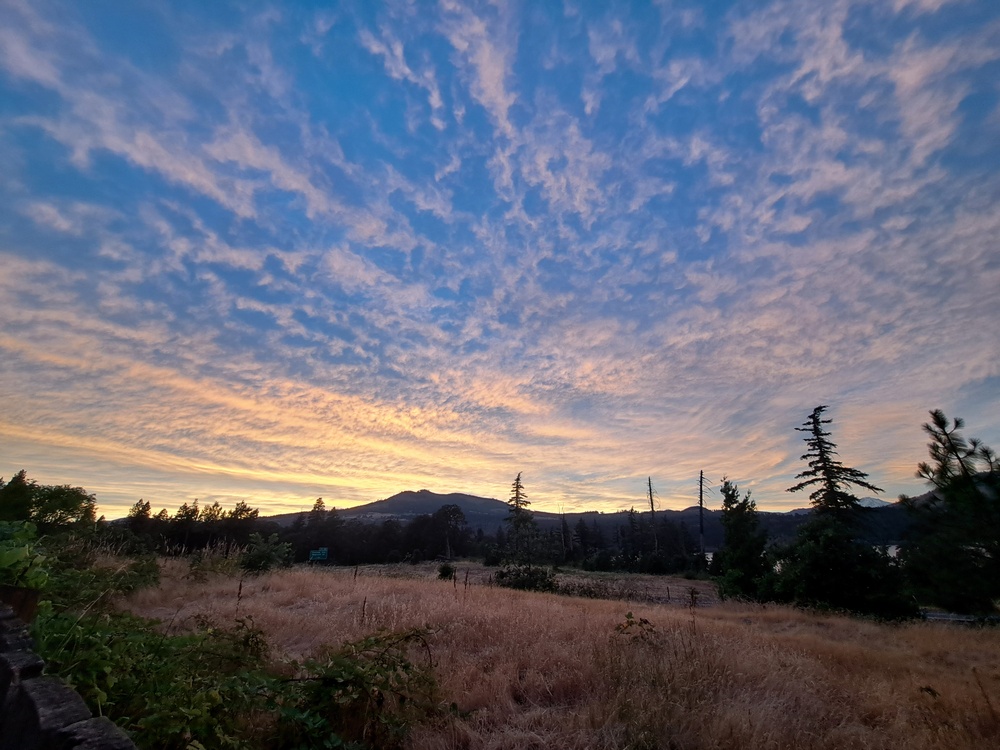
Friday looks similar to Thursday temp wise, but we’ll have lots of high clouds in the morning. Sunrise looks pretty. Speaking of, how about that sunset last night. EXCELLENT! By afternoon Friday we’ll just have scattered mid-level clouds. Westerlies will be 20-25mph from Stevenson to The Dalles in the morning with 10-15mph east to the Arlington Triangle. Afternoon wind east of The Dalles rise to 25mph. Highs will be 77-89 degrees. Slightly warmer, somewhat less windy weather is forecast for Saturday.
After that, uncertainty increases, but the smart money is on warming temps into next week. Valuable Advice For Gardeners Inhabiting Neighboring Areas: looks bad for germinating stuff, but it looks great for your tomatoes, peppers, and melons. My melons look great every single day, hot or not. Betcha wish you were me. Safe travels. -TATAS
HEY! DON’T STOP READING! Is this community-focused forecast helpful to you? It sure is! It takes me a couple hours a day to write. Please join your friends and neighbors in contributing to keep it going. Venmo: @thegorgeismygym PayPal: twomirrors@gmail.com USPS: Temira / PO Box 841 / Hood River, Oregon 97031 You can test out the forecast subscription for a few days for free by signing up below. Easy! Do it!
