

GORGE WIND FORECAST
If you’re still seeing yesterday’s and it’s after 9am, try opening this in an incognito window
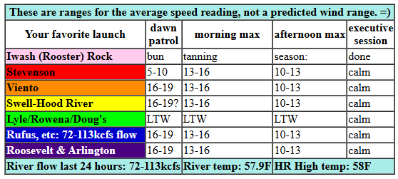
today’s gorge wind forecast
Hi friends! Not much west wind coming up, but we do have a solid east wind day in the Gorge wind forecast on Thursday and potentially next Monday. Best chance for westerlies will be today (unlikely) and Saturday (questionable). Other fun things to do if you can’t shred westerlies: find some of the great dirt before it rains again on Saturday or go play in the snow before it melts too much to play.
Looking at Wednesday… we started with pressures of 30.33/30.33/30.28. High pressure is slated to build inland. It’ll possible we could see 15-18mph for a little while this morning between Rufus and Boardman before the wind fades this afternoon. While the models don’t like the idea of Corridor wind (Viento to Hatch), I think a brief shot of 16-19ish is possible. After 2pm, you can expect nearly-calm conditions if not a glass-off. Easterlies build overnight. River flow over the last 24 hours was 72-113kcfs, river temp is 57.9F, and high temp forecast is 58F.
RIVER FLOW FOR SITES BETWEEN AVERY (EAST OF THE DALLES) AND RUFUS: CLICK HERE FOR JOHN DAY DAM FLOW.
RIVER FLOW FOR SITES BETWEEN STEVENSON AND DOUG’S BEACH (WEST OF THE DALLES): CLICK HERE FOR THE DALLES DAM FLOW

tomorrow’s gorge wind forecast
Thursday starts off with high pressure inland for a classic east wind setup. Also in place: a solid inversion that will keep the wind from spilling over the Cascades. That’s good! Opening gambit is 40-45mph at Iwash (Rooster) Rock with 30-35mph at Stevenson. As per usual, the wind fades a bit after noon. Ending play: 30mph at Iwash and 20mph at Stevenson with 15-20mph at Viento, 5-10mph near Hood River, and 10-15mph to the east. High temp: 54F after a 34F start.
extended Gorge wind forecast
Friday sees an approaching weather system. Easterlies start the day at 25mph at Iwash (Rooster) Rock and 15-20mph at Stevenson. The midday fade takes both locations down to 15mph. High temp: 55F under high overcast sky.
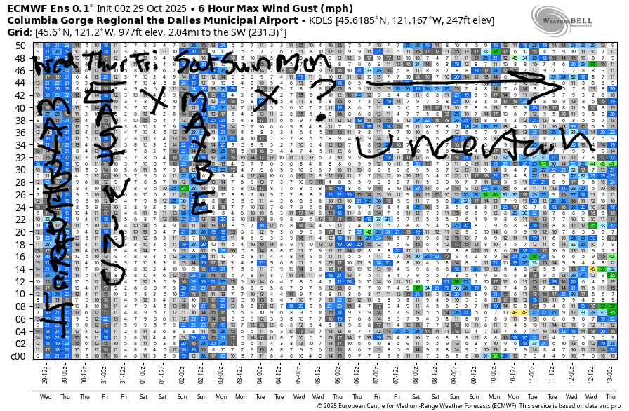
A weather system moves through on Saturday. Or maybe late Friday. The details are not yet clear. As this system moves through, we’re likely to see a period of westerlies. Models are all over the place on the strength; for now, I’d guess 18-22mph, but there’s really too much uncertainty for a certain call. Sunday: unlikely to be windy. Models are hinting at another round of easterlies on Monday, but there’s not enough consensus to add it to the calendar yet. Okay. That’s all for now. Have a great day out there in the Gorge. I’ll see you on the Nch’i Wana!
Was that helpful? I knew it was! Guess what? All of this crucial work – from your personal wind and snow reports to the invaluable TATAS updates – is made possible by my relentless efforts. Maintaining this labor of love isn’t easy. Each daily forecast takes hours. Website hosting, weather model access, and back-end admin work takes time and money. That’s where you come in.
YOUR CONTRIBUTION MAKES A DIFFERENCE
- SUPPORT ACCURATE, HYPER-LOCAL WEATHER FORECASTING
- ENABLE ACCESS FOR ALL, EVEN THOSE WITH LESS MEANS
- SUPPORT A COOL HUMAN WHO WORKS HARD SO YOU CAN PLAY
Take a moment to click one of the buttons below. Donate $19.99 or more (how much does this forecast enhance your life?) and get the email in your inbox. Whether it’s a renewing subscription (auto-renew) or a one-time donation, every contribution makes a real difference. Help me keep this labor of love alive, so we can all continue playing, commuting, and living in the Gorge with peace of mind and the best weather forecasts possible. Thank you!


Hood River, Oregon 97031


MT HOOD SNOW FORECAST

THIS FORECAST IS HIBERNATING AGAIN – NOT MUCH TO SAY. IT’LL BE BACK AS SOON AS THERE’S ANOTHER ROUND OF SNOW IN THE MT HOOD FORECAST!
BARE BONES HOOD RIVER WEATHER FORECAST
Clouds this morning with a shot at a tiny bit of drizzle. Mostly clear later. Temps start in the upper 40s and rise to the upper 50s. Light westerlies this morning. Calm later. No rainbows. Thursday will be cloudy then clear. Temps start in the mid 30s and rise to the mid 50s. Light to moderate easterlies. No rainbows. Friday will be high overcast. Temps start in the mid 30s and rise to the mid 50s. Light easterlies or calm wind. No rainbows.
TEMIRA’S AWESOME TRAVEL ADVISORY SERVICE
HYPERLOCAL WEATHER FORECAST FOR THE COLUMBIA GORGE
THE DALLES, HOOD RIVER, WHITE SALMON, TROUT LAKE, STEVENSON, CASCADE LOCKS, PARKDALE, ODELL, HUSUM, BZ, MILL A, WILLARD, GOLDENDALE, RUFUS, ARLINGTON, boardman
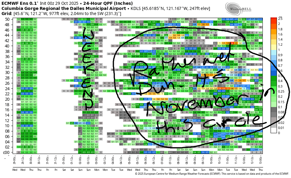
Good morning, neighbors! Piece of advice: if you know you can’t drink coffee after noon, don’t drink coffee after noon. For more sage advice, come to my meditation class. For weather thoughts, keep on reading! Weather: rather unexciting for the next six days or so other than some rain that arrives late Friday or early Saturday or midday Saturday. Despite being attached to a strong atmospheric river, this rain probably won’t be all that intense due to lack of “oomph”, a technical weather term meaning “nudge”, “shove”, “energy” or “juice”.
Glenwood this morning
If you, like I, slept like poop last night due to drinking coffee after noon, you may be feeling like that Saturday system – drained of energy. Don’t despair. Coffee time is here! Glenwood is meeting coffee with a warm start: 47 degrees. Everyone there is looking in their pantry to see what they can share with hungry neighbors come 11/1 when the SNAP benefits don’t arrive.
17% of people in Glenwood (and Klickitat County) live under the poverty line and receive SNAP, which means that 83% of the people in Glenwood are stepping up to help them. 19% of people in Wasco County are on SNAP, 11% in Hood River County, 5% in Skamania County, 17.5% in Sherman County, and 14.6% of people in Gilliam County. And no, folks, undocumented immigrants cannot get SNAP benefits. Nor can they get federally funded health insurance. Back to SNAP – somewhere between 1 in 20 and 1 in 5 people in the Gorge are receiving federal food assistance (SNAP). Please call your reps (and their donors, whose names you can see on FEC.gov) and let them know what you think of them starving your neighbors.
At least people will be hungry and somewhat warm for the next two weeks. Oh, wait, federally-funded heat assistance is also affected… At least it’s not freezing cold. Yet. Save a prayer for all of us… this is far from the end of the cruelty.
Please make a cash donation to your local food bank.
FISH (Hood River)
WGAP (Washington side)
Wednesday’s Gorge weather forecast
Wednesday’s weather? Mostly cloudy to start and mostly sunny this afternoon. That’s a combo I support! After a 40-something degree start, temps max out in the upper 50s to the west and right around 60 from The Dalles eastward. Wind will be light westerly this morning and will turn dead calm this afternoon. Dead calm is gonna be the look on my face but not the words coming out of my mouth if I see Cliff Bentz out and about. Ooooh, he’s gonna get an earful from me!
Thursday’s Gorge weather forecast
Thin high clouds on Thursday morning won’t be a thick enough blanket to prevent frost. You’ll find some of that slippery cold stuff scattered out and about thanks to low dewpoints. Near the Big River, east of Viento, a little Nothing is possible. Away from it: frosty spots as we drop into the low to mid 30s many locations. In the east wind windy zones (you know who you are) temps will be above freezing in the morning as the air mass turns over like a pancake in my cast iron skillet that I found on the side of the road. “Skillet” is a great word! Afternoon temps rise to the mid 50s. Clouds stick around east of Mosier, and the sky clears to the west. This gives us a gorgeous sunset somewhere under the lingering clouds. Other Thursday news: east wind at 40-45mph near Iwash (pecker) Rock and east wind at 35mph near Stevenson. Easterlies slow fall to 30/20mph respectively and rise to 10-15mph east of Hood River.
Friday’s Gorge weather forecast
Overnight into Friday, we’ll have some high clouds. Again, not thick enough to prevent a light frost; the day starts in the mid 30s. Afternoon temps rise to the mid 50s under high overcast sky. Easterlies will be 25mph near Cock Rock early with 15-20mph near Stevenson. The wind drops to 15mph in the afternoon at the usual windy spots and will be nearly calm elsewhere. Oh yeah… Friday is Halloween. As of this morning, models hold back the rain (for us, anyway) until Saturday. Fingers crossed!
Saturday’s Gorge weather forecast
Rain swings through at some point Saturday. Despite the intensity of the atmospheric river, we’re unlikely to see intense rain due to lack of forcing. All the force that normally goes with the pineapple express has been siphoned off by the ICE goons. Bastards. Give us back our forcing so we can have lots of rain! And so everyone can live with less fear and anger and outrage in their hearts. May you, yes you, feel safe today. May you experience the kindness of strangers. May you find peace. Safe travels. -TATAS
HEY! DON’T STOP READING! Is this community-focused forecast helpful to you? It sure is! It takes me a couple hours a day to write. Please join your friends and neighbors in contributing to keep it going. Venmo: @thegorgeismygym PayPal: twomirrors@gmail.com USPS: Temira / PO Box 841 / Hood River, Oregon 97031 You can test out the forecast subscription for a few days for free by signing up below. Easy! Do it!
JONES BEACH, SAUVIE ISLAND, & COAST FORECAST
ON WINTER VACATION! MIGHT SHOW UP IF NEEDED!
