

MT HOOD WEATHER FORECAST
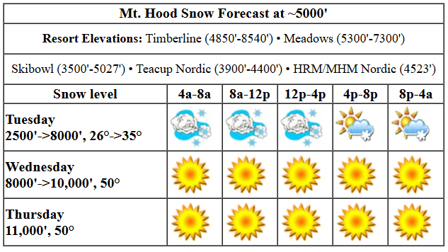
Hey skiers and snowboarders! It’s going to be quite the day up there on the mountain. Stormy. Meadows already made the call to shut down today due to extreme wind. No word yet from T-Line and Skibowl as I was writing this. It’s Tuesday, so there’s won’t be word from Teacup – they don’t groom today. The chaos is due to a low swinging up the coast. Sadly, the bulk of the moisture associated with this has shifted north, and that’s knocked snow totals way down – Meadows reported 5” overnight. After today, high pressure builds in hard and fast, and temps skyrocket on the slopes; we’re looking at highs around 50 degrees Wednesday through Friday. Next snow: Sunday.
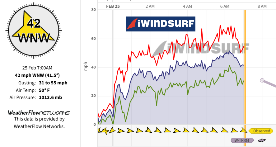
Your best shot for shredding today will be Skibowl, as Meadows is shut down and Timberline will struggle to run lifts in this much wind. At 6am, the last-hour report from the top of Mt. Hood Express was 43 average with a gust of 91mph. Today’s Mt Hood weather forecast: the snow level will be around 2500′ all day. The sky clears overnight, and the free air freezing level rises to 8000′. Temps hold around 26F at 5000′ all day and rise above freezing tonight. Wind will be WSW 60-70 early, W 65 midday (that’s always a complete shutdown), and WNW 45 in the afternoon. Overnight, the wind speed plummets to light/variable. With the moisture shifting north, available moisture has dropped – we were expecting over a foot today. Now models suggest 0.3” to 0.7” water equivalent (WE). That’s 3-7” of new snow. Given the incredible orographic forcing with all this wind, we could see double that. Fingers crossed. The snow we do get will be transformed to wind slab and sastrugi by all this wind. Lower slopes will have better conditions by far than upper slopes should you head up on Wednesday.
Get on it early Wednesday, because warming will affect the snow quickly. The free air freezing level will be 8000′ in the morning, 10,000′ in the afternoon, and 11,000′ after midnight. Temps rise from the low to mid 30s in the morning to 50 degrees in the afternoon. Wow! Wind will be light/variable early, S 10-20 in the afternoon, and SW 10-15 after midnight.
Warm, sunny, light-wind weather is forecast Thursday, Friday, and /Saturday. The free air freezing level holds above 10,000′ for the period, and temps max out at 50F or more each day. With clear sky overnight, the snow should refreeze each night. Hopefully this will turn the snowpack from a sticky, slushy mess to corn snow before the next round of snow on Sunday. If not, ah well. Waxing correctly will be key this week. Sunday starts sunny, but snow is likely in the afternoon, although the timing could change as we’re still many days out. Generally speaking, the extended forecast looks snowy. Have a great day today!
Liking this forecast?
Was that helpful? I knew it was! Guess what? All of this crucial work – from your personal wind and snow reports to the invaluable TATAS updates – is made possible by my relentless efforts. Maintaining this labor of love isn’t easy. Each daily forecast takes hours. Website hosting, weather model access, and back-end admin work takes time and money. That’s where you come in.
YOUR CONTRIBUTION MAKES A DIFFERENCE
- SUPPORT ACCURATE, HYPER-LOCAL WEATHER FORECASTING
- ENABLE ACCESS FOR ALL, EVEN THOSE WITH LESS MEANS
- SUPPORT A COOL HUMAN WHO WORKS HARD SO YOU CAN PLAY
Take a moment to click one of the buttons below. Donate $19.99 or more (how much does this forecast enhance your life?) and get the email in your inbox. Whether it’s a renewing subscription (auto-renew) or a one-time donation, every contribution makes a real difference. Help me keep this labor of love alive, so we can all continue playing, commuting, and living in the Gorge with peace of mind and the best weather forecasts possible. Thank you!


Hood River, Oregon 97031


GORGE WIND FORECAST

Hi friends! Fun day on tap today. Couple of safety things: it’s going to be very windy, and the water is very cold. Keep an eye on your buddies. Next, due to all the recent rain, there will be a ton of debris in the river – the farther west you are, the more debris there will be. Okay. At 6am, we already had onshore gradients and strong westerlies west of Hood River. At 6am, Viento was reading 49mph and the Hatch was reading 30mph. Wow. That’s the plan for this morning, but the Hatch will be up and down due to rain.
Tuesday morning forecast: nuking westerlies at 30+mph west of Hood River, 25-35mph from Hood River to Doug’s, and 35-40mph (after 10am) from Avery all the way to Boardman. NWS has a wind advisory in effect for gusts to 55mph today. The wind drops from west to east early to mid afternoon as high pressure builds inland. Mid-afternoon westerlies will be 22-25 from Stevenson to Doug’s with 29-33 from Avery to Boardman. Executive session: 13-16 or less west of The Dalles with 24-27 from Avery to Boardman. River flow over the last 24 hours was 84-169kcfs, river temp is 37.76F, and high temp forecast is 50F (Hatch) to 55F (Boardman) with partly cloudy sky in the west and mostly clear sky out east. Be safe out there!
Easterlies return on Wednesday. You’ll find 35mph all day at Iwash (Rooster) Rock with 30-35mph most of the day at Stevenson. Stevenson drops to 25mph in the afternoon. High temp: 54F and mostly clear. Thursday starts with 35mph at Iwash and 25mph at Stevenson. Around noon, the downward trend begins. Stevenson ends the day at 15-20mph, and Iwash ends at 15mph. Friday looks similar. As of right now, not much wind is forecast for Saturday, but there’s some potential for westerlies on Sunday. See you on the river!
BARE BONES HOOD RIVER WEATHER FORECAST
Clouds and rain this morning give way to partly cloudy sky later. Temps start in the upper 40s and rise to 50 or so. Nuking westerlies. 99% chance of rainbows. Wednesday will be partly Nothing then mostly clear. Temps start in the low 30s and rise to the mid 50s. Light easterlies. No rainbows. Thursday will be partly Nothing then mostly clear. Temps start in the mid 30s and rise to the upper 50s. Light easterlies. No rainbows.
TEMIRA’S AWESOME TRAVEL ADVISORY SERVICE
HYPERLOCAL WEATHER FORECAST FOR THE COLUMBIA GORGE
THE DALLES, HOOD RIVER, WHITE SALMON, TROUT LAKE, STEVENSON, CASCADE LOCKS, PARKDALE, ODELL, HUSUM, BZ, MILL A, WILLARD, GOLDENDALE, RUFUS, ARLINGTON, boardman
Good morning, neighbors! It’s quite a start to the day – blasting west wind west of Hood River, enough that there were some trees down on I-84 according to my friend who just drove this way from the metro area. The entire Gorge, including the foothills, will have strong wind today. With the saturated ground, trees are likely to fall. Be careful out there! Everything calms down tonight, and we’re left with sunny, warm weather for the next four days. Just like that, temporary spring is here! Briefly. I hear my garden calling. Do you hear what I hear?
glenwood and tatas eootd
Before we dive into all of today’s exciting news, let’s check in with Glenwood. Looks like they’re 40F with light wind and a dewpoint of 35F. It’ll get windy there today too. TATAS Executive Order Of The Day: universal option to vote by mail. Signed with my red, white, and blue pen. With glitter for stars.
tuesday
Tuesday’s main topic is wind. Last I looked, Viento was blowing 35-60mph, averaging 47mph, which would earn us a high wind warning of some sort, but NWS doesn’t issue those for the central Gorge. There is a wind advisory posted by NWS Pendleton. Expect west wind at 30-40mph+ all the way from Stevenson to Boardman today. Rain extends to Mosier this morning and tapers off this afternoon; we’ll all be dry tonight. Temps max out around 50 degrees on the west side today with 55 degrees out in the desert.
wednesday
Much, much, much calmer weather is forecast Wednesday through Saturday. Are you summer clothes packed away? Dig them out for the next four days. You’ll be happy you did, as your skin will be manufacturing you some much-needed Vitamin D. On Wednesday, the day starts partly Nothing near the Nch’i Wana and sunny away from it. Areas above the Nothing will dip below freezing despite above-freezing temps in the mountains. Thank you, radiational cooling, Temps rise to the mid 50s in the lowlands and 50F in the mountains on Wednesday. Wind will be E 35mph near Iwash (dick) Rock and 25-30mph near Stevenson. Elsewhere: light/variable.
…and beyond…
Copy and past that forecast for Thursday with less wind, a high temp in the upper 50s, and a shot at a gorgeous sunrise thanks to high clouds on the west side early. Friday: ditto, minus the sunrise. Temps max out around 60F. OMG, hell yes! Saturday: ditto, with potentially less wind at Iwash, giving you a chance to head to the nude beach to give your iwash some sun. Rain returns sometime Sunday. Models hint at the potential for a couple dry days after that, and follow that up with more rain. Safe travels. -TATAS
HEY! DON’T STOP READING! Is this community-focused forecast helpful to you? It sure is! It takes me a couple hours a day to write. Please join your friends and neighbors in contributing to keep it going. Venmo: @thegorgeismygym PayPal: twomirrors@gmail.com USPS: Temira / PO Box 841 / Hood River, Oregon 97031 You can test out the forecast subscription for a few days for free by clicking this link: https://subscribepage.io/YhevGc
