

MT HOOD SNOW FORECAST

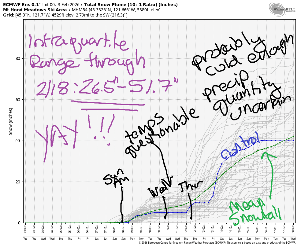
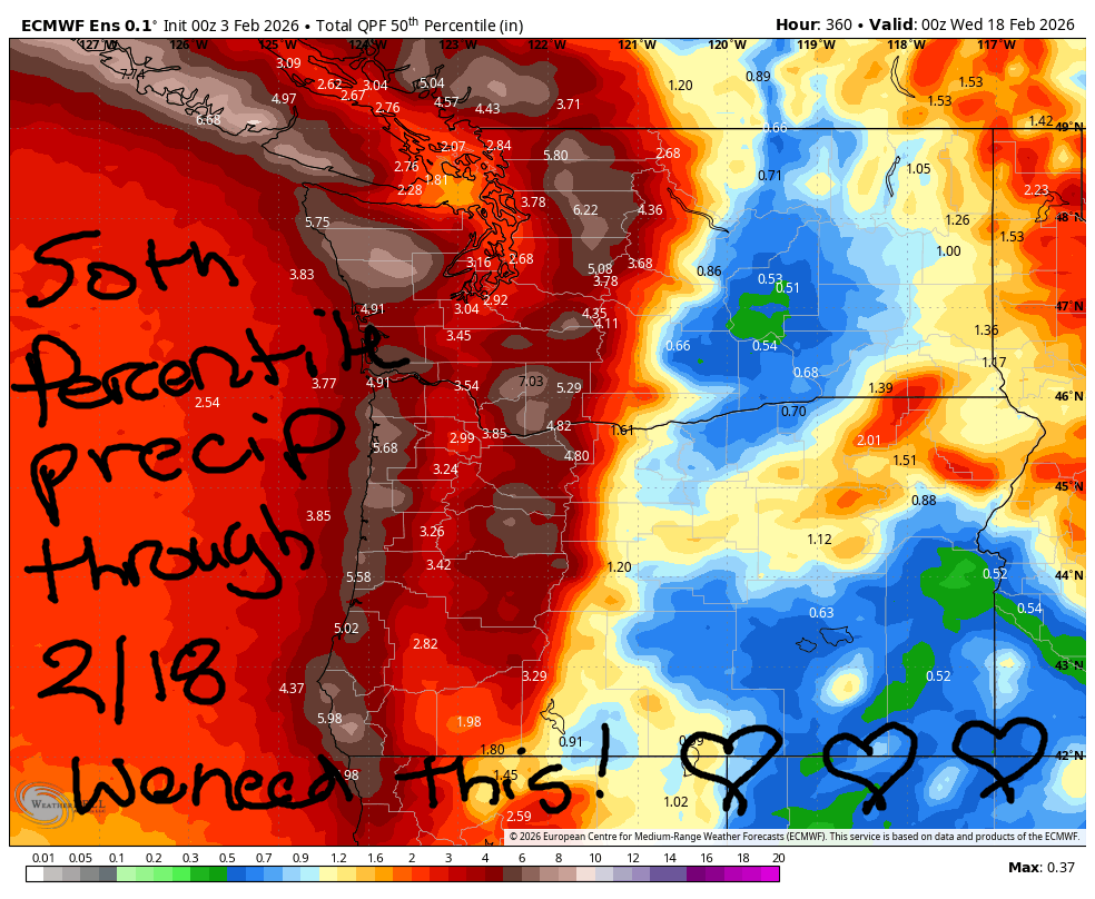
Hey skiers and snowboarders! Good news in the forecast! While this week looks warm and sunny on the slopes and in the valleys, a significant pattern change is coming starting Sunday. We’re expecting colder temps along with enough precipitation to revamp conditions on Mt Hood. As of this morning, the ECMWF ensemble intraquartile range (25th-75th percentile) for snowfall on Mt Hood through 2/18 is 26.5”-51.7”. As always, we vote for the high end of that range!
So, get your sunshine this week. Speaking of, since nothing is changing for a couple days, I’m going to take Wednesday off for forecasting and claw back a couple hours to work on my taxes. So. Fun!
Short term Mt Hood snow forecast
Tuesday’s Mt Hood forecast is for mostly clear sky most of the day with high clouds in the afternoon and night. The free air freezing level will be above 10,000′ all day with temps at 5000′ rising to nearly 50F. Wind will be SE 15 in the morning, SW 5-10 this afternoon, and light southerly overnight. Snow surface is frozen granular this morning thanks to radiational cooling overnight. Many areas will soften to corn snow or spring skiing depending on their sun exposure today. Conditions will be the same all week long, so I won’t repeat that for the rest of the forecast!
Wednesday starts with thin high clouds and quickly turns completely clear. The free air freezing level (FAF) will be 12,000′ or more all day. Temps max out in the mid 50s at 5000′ as 850mb temps rise to +14C. Warm! Expect a firm snow surface early and spring conditions later. Wind will be S 5-10mph all day turning to SE 10-15 overnight.
Extended Mt Hood Snow Forecast
Thursday sees another warm, sunny day on the slopes. Temps max out in the low 50s, the wind stays under 20mph, and a few high clouds join in the afternoon. Slightly cooler weather is forecast on Friday as an inconsequential weak weather system slides through. The freezing level falls from 10,000′ to 8000′, and temps drop to the upper 30s in the afternoon. Wind will be SW 5-10 early. It rises to SW 15-25 in the afternoon and holds overnight. Saturday: cloudy, temps in the upper 30s, SW wind at 15-25mph.
The pattern (probably) breaks down on Sunday as a cold front arrives from the NW. This is a good direction for bringing 1) colder weather and 2) snow. Indeed, models call for both. Quantity: unclear for now. This system opens the door for additional systems next week. The long-range forecast looks mostly cold enough (possible exception 2/10-2/12) and mostly wet enough to save ski season. Keep crossing your fingers for the high end of the IQ range. See you on the snow soon!
Was that helpful? I knew it was! Guess what? All of this crucial work – from your personal wind and snow reports to the invaluable TATAS updates – is made possible by my relentless efforts. Maintaining this labor of love isn’t easy. Each daily forecast takes hours. Website hosting, weather model access, and back-end admin work takes time and money. That’s where you come in.
YOUR CONTRIBUTION MAKES A DIFFERENCE
- SUPPORT ACCURATE, HYPER-LOCAL WEATHER FORECASTING
- ENABLE ACCESS FOR ALL, EVEN THOSE WITH LESS MEANS
- SUPPORT A COOL HUMAN WHO WORKS HARD SO YOU CAN PLAY
Take a moment to click one of the buttons below. Donate $19.99 or more (how much does this forecast enhance your life?) and get the email in your inbox. Whether it’s a renewing subscription (auto-renew) or a one-time donation, every contribution makes a real difference. Help me keep this labor of love alive, so we can all continue playing, commuting, and living in the Gorge with peace of mind and the best weather forecasts possible. Thank you!


Hood River, Oregon 97031


GORGE WIND FORECAST
If you’re still seeing yesterday’s and it’s after 9am, try opening this in an incognito window
SHORT-TERM gorge wind forecast
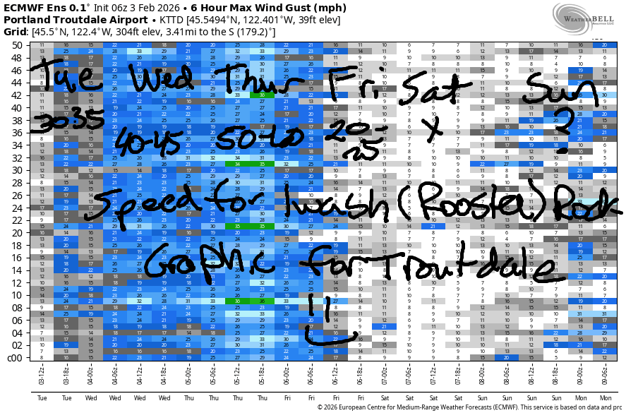
Hi friends! It’s another week of easterlies as another high pressure ridge takes hold of the Pacific Northwest. Windiest day this week will be Thursday, with the windiest pair being Wednesday-Thursday, should you wish to travel here for wind. Tuesday started with pressures of 30.33/30.44 and easterlies already rocking the boat: 35mph at Iwash/Rooster, 20mph at Stevenson, and 15-20mph at Viento. Easterlies rise to 30mph at Stevenson before fading to 20-25mph this afternoon. Iwash drops to 30mph after 1pm. River flow over the last 24 hours was 146-191kcfs, river temp is 40.6F, and high temp forecast is 52F with sun or filtered sun in the windy zones.
Wednesday starts with 40-45mph at Iwash and 30mph at Stevenson. These strong easterlies hold until noon, when they drop a bit: 35mph at Iwash to finish the day and 20-25mph at Stevenson. High temp: low 50s with sunshine in the east wind zones.
RIVER FLOW FOR SITES BETWEEN AVERY (EAST OF THE DALLES) AND RUFUS: CLICK HERE FOR JOHN DAY DAM FLOW.
RIVER FLOW FOR SITES BETWEEN STEVENSON AND DOUG’S BEACH (WEST OF THE DALLES): CLICK HERE FOR THE DALLES DAM FLOW

LONGER-TERM gorge wind forecast
Thursday will be the windiest day of the week. It’ll also be the day with the most persistent Nothing cloud, so you may want to go wind-sporting in the sunny zones! Iwash starts with 50-60mph in the morning and fades to 40mph in the afternoon. Stevenson peaks at 35-40mph mid-morning before fading to 30mph in the afternoon. High temp: 51F with (you got it) sun in the east wind zones.
Lesser wind is forecast on Friday, perhaps 20-25mph at Iwash, as the ridge starts breaking down. Saturday brings light easterlies or light/variable wind. A cold front sweeps through on Sunday bringing some rain. For now, the impact of this on the wind is uncertain, so we’ll have to wait and see. Stay safe out there – dress warmly, keep an eye on your buddies, and have an emergency plan!
BARE BONES HOOD RIVER WEATHER FORECAST
Nothing this morning. Partly Nothing plus some high clouds later. Temps start in the upper 30s and rise to the low 50s. Light to moderate easterlies. No rainbows. Wednesday will be Nothing. Temps start in the upper 30s and rise to the low 50s. Moderate easterlies. No rainbows. Thursday will be Nothing. Temps start in the mid 30s and finish in the low 50s. Moderate easterlies. No rainbows.
TEMIRA’S AWESOME TRAVEL ADVISORY SERVICE
HYPERLOCAL WEATHER FORECAST FOR THE COLUMBIA GORGE
THE DALLES, HOOD RIVER, WHITE SALMON, TROUT LAKE, STEVENSON, CASCADE LOCKS, PARKDALE, ODELL, HUSUM, BZ, MILL A, WILLARD, GOLDENDALE, RUFUS, ARLINGTON, boardman
Good morning, neighbors! With the exception of some changes in wind speed through the commute corridor (you know – near Iwash Rock), the weather will be pretty much the same every day through Friday. Change arrives in the form of clouds on Saturday, and actual precipitation is forecast on Sunday as part of a larger overall pattern change to cooler-and-wetter. The unchanging weather this week means I get to take a day or two off, yay. I’ll start by taking Wednesday off.
Glenwood this morning
So we better dive in today, because I might have senioritis from anticipating a day off. Glenwood this morning was boasting a low temp of 29F. That’s double the degrees Glenwood should have this morning. It’s okay, Glenwood. Don’t feel ashamed. You’re not alone in under-performing. Everyone is super-warm this winter. For example, the average high temp this week is supposed to be 40F, but we’ll be 50F (or more) all week long. With Nothing hanging around this morning, you may encounter fog, freezing fog, and/or frosty roads in select areas. So far this morning, nobody has spotted any !CE.
The rest of this unchanging week of weather
Morning temps this week slide a degree or two each day as the momentum of radiational cooling builds. Afternoon temps will generally be around 50F with perhaps a degree or two or three more away from the Nothing. And yes, the Nothing will be here all week long. It may break up on Tuesday and Wednesday and Friday, but it’s likely to stick around all day long on Thursday. In South Wasco and Sherman Counties, fog is possible on Wednesday and Thursday. I’m trying, Sherman County person who sent me a letter asking!
The part where the weather changes
Moving on to next weekend… clouds arrive on Saturday. A pattern change to “wet” is likely on Sunday. With systems coming from the northwest, it’s likely we’ll see some rain-shadowing between Hood River and The Dalles and also in south Wasco County. We’re still a good while from this pattern change, and the timing is likely to shift some. It is worth noting that models are FINALLY hinting at some significant snowfall in the mountains. We need it. As of right now, we’re huddled up against 2004-2005, the worst snow year ever. If the forecast beyond this week is correct, we’ll create some distance between us and that disastrous season’s records. Yay. Safe travels. -TATAS
HEY! DON’T STOP READING! Is this community-focused forecast helpful to you? It sure is! It takes me a couple hours a day to write. Please join your friends and neighbors in contributing to keep it going. Venmo: @thegorgeismygym PayPal: twomirrors@gmail.com USPS: Temira / PO Box 841 / Hood River, Oregon 97031 You can test out the forecast subscription for a few days for free by signing up below. Easy! Do it!
JONES BEACH, SAUVIE ISLAND, & COAST FORECAST
ON WINTER VACATION UNLESS DESPERATELY NEEDED.
