

MT HOOD SNOW FORECAST

Hey skiers and snowboarders! Sunny weather continues on the slopes through the rest of this week and potentially into the weekend. Models suggest this pattern will break down next Monday. It’s possible we could see a little snow then before another period of mostly dry, rather mild weather settles in to the Pacific Northwest. One of the best ways to look at snow potential over the next couple of weeks is the intraquartile range, the 25th percentile snowfall to the 75th percentile. It’s not pretty: 2.4” to 9” of snowfall on Mt Hood through February 3rd. That’s not much, eh?
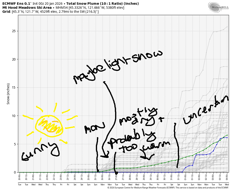
Short term Mt Hood snow forecast
Tuesday looks like another sunny day on Mt Hood. The free air freezing level (FAF) will be above 10,000′ all day with a big inversion in place. Temps max out in the upper 40s at 5000′ today. Wind will be north 10 early in the morning but will quickly turn to E 15-20 midday. This will result in wide swings in temps as the warm elevated air mass encounters cool air on the east side.
Wednesday will also be sunny. The FAF starts around 11,000′ and slowly falls to 8000′ after midnight. Temps max out in the upper 40s, but once again, temps will vary widely with elevation and location. Wind will be variable to 10mph. Thursday: sunny, not very wind, and cooler: temps max out in the upper 30s as cooler east side air starts to dominate. Friday will be ever cooler, but will still be sunny. Easterlies (probably) pick up in the afternoon to 20-25mph.
Extended Mt Hood Snow Forecast
Sunshine continues on Saturday. We may see some high clouds on Sunday. Models hint at light snowfall on Monday. That’s a long ways out to predict timing and/or quantity, but my fingers are definitely crossed for some fresh snow. We need it! In the meantime, get up there and ride the day away in the sun.
One last note… if you have any interested at all in skate skiing (I think it’s awesome), now is the time to learn. Conditions are absolutely perfect!
Was that helpful? I knew it was! Guess what? All of this crucial work – from your personal wind and snow reports to the invaluable TATAS updates – is made possible by my relentless efforts. Maintaining this labor of love isn’t easy. Each daily forecast takes hours. Website hosting, weather model access, and back-end admin work takes time and money. That’s where you come in.
YOUR CONTRIBUTION MAKES A DIFFERENCE
- SUPPORT ACCURATE, HYPER-LOCAL WEATHER FORECASTING
- ENABLE ACCESS FOR ALL, EVEN THOSE WITH LESS MEANS
- SUPPORT A COOL HUMAN WHO WORKS HARD SO YOU CAN PLAY
Take a moment to click one of the buttons below. Donate $19.99 or more (how much does this forecast enhance your life?) and get the email in your inbox. Whether it’s a renewing subscription (auto-renew) or a one-time donation, every contribution makes a real difference. Help me keep this labor of love alive, so we can all continue playing, commuting, and living in the Gorge with peace of mind and the best weather forecasts possible. Thank you!


Hood River, Oregon 97031


GORGE WIND FORECAST
If you’re still seeing yesterday’s and it’s after 9am, try opening this in an incognito window
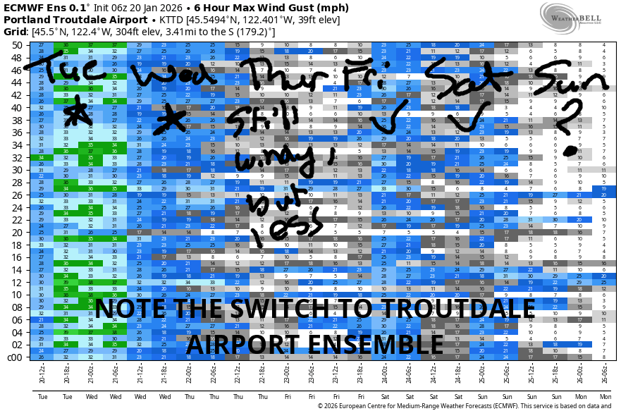
SHORT-TERM gorge wind forecast
Hi friends! Your mid-winter nuke-fest continues for several more days. Keep on keeping on! As always, dress warmly, have an emergency plan, and keep an eye on your buddies. Tuesday kicked off with pressures of 30.25/30.40/30.48 with strong wind. Pre-dawn readings were 49mph at Iwash (Rooster), 28mph at Stevenson, and 22mph at Viento. The wind builds this afternoon. Iwash hits nearly 60mph, and Stevenson rises to 35-40mph. River flow over the last 24 hours was 203-214kcfs, river temp is 42.4F, and high temp forecast is 39F with sunshine in the east wind zones.
Wednesday will be another windy day. Iwash starts with 45-50mph, and Stevenson starts with 30mph. The wind holds through midday and then drops a little. Stevenson finishes with 25-30mph, and Iwash ends the day with 3540mph. High temp forecast is 39F with sunshine in the windy zones.
RIVER FLOW FOR SITES BETWEEN AVERY (EAST OF THE DALLES) AND RUFUS: CLICK HERE FOR JOHN DAY DAM FLOW.
RIVER FLOW FOR SITES BETWEEN STEVENSON AND DOUG’S BEACH (WEST OF THE DALLES): CLICK HERE FOR THE DALLES DAM FLOW

LONGER-TERM gorge wind forecast
Thursday looks slightly less windy. Iwash starts with 40-45mph and finishes with 25-30mph. Stevenson starts with 30-35mph and finishes with 20-25mph. High temp forecast is 39F with sunshine in the morning and partly cloudy sky in the afternoon.
Friday and Saturday look somewhat less windy – Iwash maxes out at 30-35mph on Friday with Stevenson at 25-30mph. ON Saturday, Iwash starts with 45mph and finishes at 25mph. Models hint at this weather pattern starting to break down Sunday into Monday which would result in lesser east wind. So if you’re going to get it, get it now. Have fun and be safe!
BARE BONES HOOD RIVER WEATHER FORECAST
Nothing today with a slight chance of lesser Nothing this afternoon. Temp start in the low 30s and rise to the mid 30s. Light to moderate easterlies. No rainbows. Wednesday will be Nothing then partly Nothing to mostly clear. Temps start in the upper 20s and rise to the upper 30s. Light to moderate easterlies. No rainbows. Thursday will be Nothing then partly cloudy. Temps start in the upper 20s and rise to the upper 30s. Light easterlies. No rainbows.
TEMIRA’S AWESOME TRAVEL ADVISORY SERVICE
HYPERLOCAL WEATHER FORECAST FOR THE COLUMBIA GORGE
THE DALLES, HOOD RIVER, WHITE SALMON, TROUT LAKE, STEVENSON, CASCADE LOCKS, PARKDALE, ODELL, HUSUM, BZ, MILL A, WILLARD, GOLDENDALE, RUFUS, ARLINGTON, boardman

Good morning, neighbors! It’s another morning of Nothing here in the Gorge. You can swap it for sunshine and wind by heading west, and you can swap it for sunshine and calm, mild weather by heading up above the gray blanket. Models hint at lower-humidity air drifting in from the east over the next few days. If this manifests, we’ll see a better chance of Nothing-free sky. Fingers crossed! When will this overall pattern dissipate? Not until next Monday, when models finally bring in a little bit of precipitation. We’ll take anything we can get – the snowpack is currently at only 34% of normal and not much above the lowest year ever.
Glenwood this morning
Looking around the Gorge this morning, we have an impressive Nothing cloud. It’s so thick that’s it’s drizzling and freezing drizzling. Parkdale is in the Nothing, and Meadows is above it. Somewhere between 1500′ and 4500′, the Nothing is lurking. Driving through it, you’ll encounter frosty roads and the potential for freezing fog and beautiful rime-coated trees. Glenwood started the day at 26F – it’s starting each day a little cooler, as are many of us. Expect this pattern to continue as radiational cooling steals a degree or two more each night.
Today’s Gorge weather forecast
Tuesday’s weather will be just like yesterday’s: gray in the central and eastern Gorge and sunny and windy in the western Gorge. East wind builds to 60mph at Iwash (release the files!) Rock, 35-40mph at Stevenson, and 10-20mph in the foothills. Models hint at some dissipation of the Nothing this afternoon away from the Nch’i Wana.
Know what else happens today? At 2pm, people who are unsatisfied with the prominence of violence and cruelty in the USA will be walking off their jobs in support of the #FreeAmerica Walkout. If you feel strongly that things are going in the wrong direction, and if you feel you can safely leave work, join in! There’s a protest at 2pm at Overlook Memorial Park (aka the Salmon Fountain, aka 2nd and State) in Hood River, and there’s another protest, a walking one, in White Salmon at 2pm. A third protest happens at the corner of N Oak and E Steuben in Bingen. My apologies for not mentioning yesterday’s “Day Without Immigrants” protest in The Dalles – I took the day off and spaced posting it. Immigrants make this country great. Immigrants get the job done!
Wednesday’s Gorge weather forecast
Wednesday’s weather offers up a slightly different take on things. Thanks to less-humid air, we’re more likely to break out of the Nothing. Models start the day Nothing in the Central and eastern Gorge near the Nch’i Wana, but areas away from it might start clear. If they do, they’ll start the day in the mid 20s. Rest of us: low to mid 30s. Afternoon, if the forecast pans out, ends partly cloudy to the east and clear to the west. Strong east wind continues in the usual spots.
Extended Gorge weather forecast
Thursday looks nearly identical to Wednesday. Friday does too. Maybe Saturday as well. High clouds filter in on Sunday ahead of a possible wet system early next week. It’s too soon to tell exactly when the system will arrive, and it’s also too soon to tell how much moisture it will bring. Know what else it’s too soon for? Knowing if it will snow in the Gorge. We’ll watch this closely. Stay warm out there, folks! Take care of each other. Be kind. Safe travels. -TATAS
HEY! DON’T STOP READING! Is this community-focused forecast helpful to you? It sure is! It takes me a couple hours a day to write. Please join your friends and neighbors in contributing to keep it going. Venmo: @thegorgeismygym PayPal: twomirrors@gmail.com USPS: Temira / PO Box 841 / Hood River, Oregon 97031 You can test out the forecast subscription for a few days for free by signing up below. Easy! Do it!
JONES BEACH, SAUVIE ISLAND, & COAST FORECAST
ON WINTER VACATION UNLESS DESPERATELY NEEDED.
