

MT HOOD SNOW FORECAST

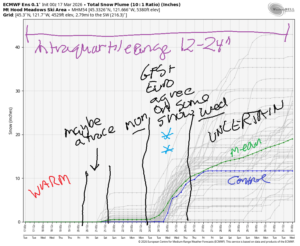
Hey skiers and snowboarders! The Winter That Wasn’t is continuing to not-be (like the old Descartes walks into a bar joke…) with warm temps on the slopes for the next few days. Models suggest we could see a dip in temps Friday into Saturday, briefly, but that’s a low probability outcome. A better chance of a period of colder, potentially snowy weather is forecast for the early to middle part of next week.
While it doesn’t look like massive snowfall, anything is better than nothing at the point. The intraquartile range through the end of March is 12-24”. Nordic skiers, judging by what I saw yesterday, you’ll want to get it soon because without more snow, it’s not going to last long. For yesterday’s skate session, I was on yellow wax. That applies to alpine folks too – a wax made for warm conditions will serve you well this week!
Short term Mt Hood snow forecast
Looking at the alpine side of things… Tuesday kicks off with partly cloudy sky. Clouds thicken this afternoon and potentially drop a few sprinkles. Measurable precipitation is unlikely. The free air freezing level (FAF) will be above 10,000′ for the 24 hour period. Temps at 5000′ max out in the low 50s. That said, the sky was clear enough last night that the snow refroze, so corn snow is in the offing today! Wind will be W 35 this morning, WSW 20-30 this afternoon, SW 15-30 this evening, and WSW 30-35 overnight.
Sunshine returns on Wednesday. The freezing level hovers over 10,000′ all day, and temps max out around 50F at 5000′. Wind will be WSW 30-35 in the morning and will become SW 15-30 from mid-afternoon on through the night. Thursday looks clear early, cloudy in the afternoon, and warm, with temps almost making it to 50F again. Wind will be SW 15-30 all day long.
Extended Mt Hood Snow Forecast
Model uncertainty skyrockets on Friday. It’s possible we could see a cold front swing through and take temps back below freezing on the slopes by Saturday morning, but that’s not certain. Even in this situation, not much precip is forecast – at best, we might pick up a couple inches of new snow. Despite high levels of uncertainty, models do want to give us a little snow for the first day or three of next week. Please! We’ll take what we can get! See you on the snow soon!
Was that helpful? I knew it was! Guess what? All of this crucial work – from your personal wind and snow reports to the invaluable TATAS updates – is made possible by my relentless efforts. Maintaining this labor of love isn’t easy. Each daily forecast takes hours. Website hosting, weather model access, and back-end admin work takes time and money. That’s where you come in.
YOUR CONTRIBUTION MAKES A DIFFERENCE
- SUPPORT ACCURATE, HYPER-LOCAL WEATHER FORECASTING
- ENABLE ACCESS FOR ALL, EVEN THOSE WITH LESS MEANS
- SUPPORT A COOL HUMAN WHO WORKS HARD SO YOU CAN PLAY
Take a moment to click one of the buttons below. Donate $19.99 or more (how much does this forecast enhance your life?) and get the email in your inbox. Whether it’s a renewing subscription (auto-renew) or a one-time donation, every contribution makes a real difference. Help me keep this labor of love alive, so we can all continue playing, commuting, and living in the Gorge with peace of mind and the best weather forecasts possible. Thank you!


Hood River, Oregon 97031


GORGE WIND FORECAST
If you’re still seeing yesterday’s and it’s after 9am, try opening this in an incognito window
SHORT-TERM gorge wind forecast
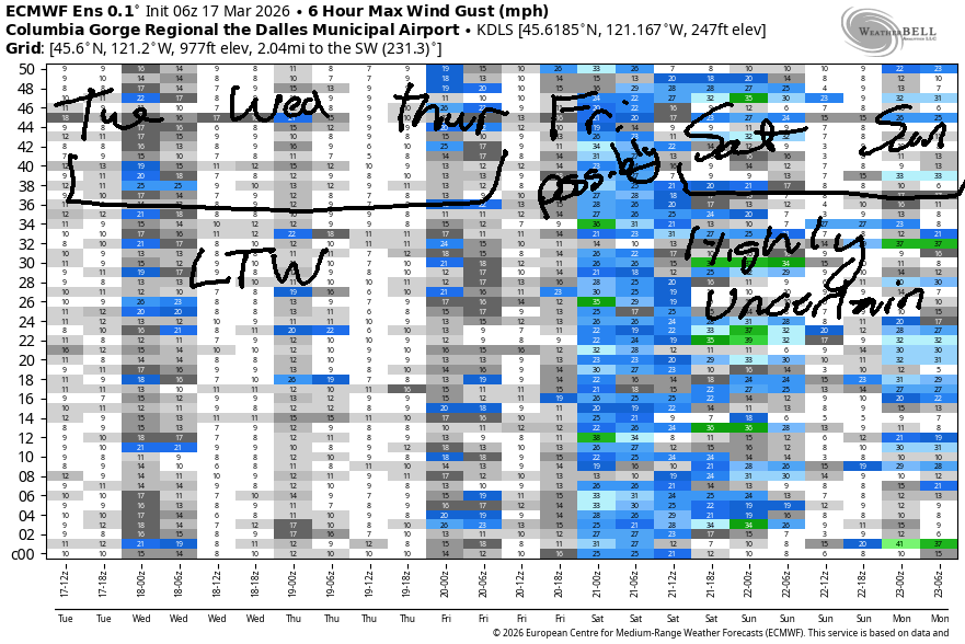
Hi friends! Not much going on this week. Next chance of stronger wind (westerly) would be Friday or Saturday, but models are calling this a low-probability opportunity for now.
Tuesday started with pressures of 30.05/30.04/29.99 for gradients of 0.01/0.05. Prior to dawn, the wind was light and variable through the entire Gorge. Models suggest the peak will be mid-afternoon from Mosier to Doug’s at 11-14mph. Not much, in other words. River flow over the last 24 hours was 191-278kcfs, river temp is 45.5F, and high temp forecast is 63F with partly cloudy sky.
Wednesday also looks light. Models have the peak at 11-14mph from Arlington to Boardman in the afternoon with less than 10mph everywhere else all day long. If you want more wind, you can head up to the ski resorts. High temp: six-seven degrees with mostly clear sky by afternoon.
RIVER FLOW FOR SITES BETWEEN AVERY (EAST OF THE DALLES) AND RUFUS: CLICK HERE FOR JOHN DAY DAM FLOW.
RIVER FLOW FOR SITES BETWEEN STEVENSON AND DOUG’S BEACH (WEST OF THE DALLES): CLICK HERE FOR THE DALLES DAM FLOW

LONGER-TERM gorge wind forecast
Thursday doesn’t look much windier. We’ll have under 10mph to start the day. Afternoon westerlies rise to 10-13mph from Stevenson to Hood River and (maybe) 16-19mph from Mosier to Arlington. High temp: 69F with mostly cloudy sky in the morning and partly cloudy sky in the afternoon.
Models suggest the possibility (low chance) of a strong cold front on Friday which could result in stronger west wind if the timing is just right. Other than that… not much wind in our future. Know what is in our future? Really nice dirt for mountain biking and some good corn skiing today!

BARE BONES HOOD RIVER WEATHER FORECAST
Mostly clear sky this morning and partly cloudy later. Temps start in the low 50s and rise to the low 60s. Light westerlies. No rainbows. Wednesday will be cloudy then partly high overcast. Temps start in the mid 40s and rise to the upper 60s. Light westerlies. No rainbows. Thursday will be mostly cloudy then partly cloudy. Temps start in the upper 40s and rise tot he upper 60s. Light westerlies. No rainbows.
TEMIRA’S AWESOME TRAVEL ADVISORY SERVICE
HYPERLOCAL WEATHER FORECAST FOR THE COLUMBIA GORGE
THE DALLES, HOOD RIVER, WHITE SALMON, TROUT LAKE, STEVENSON, CASCADE LOCKS, PARKDALE, ODELL, HUSUM, BZ, MILL A, WILLARD, GOLDENDALE, RUFUS, ARLINGTON, boardman
Good morning, neighbors! Spring’s making an appearance this week. Watch out for amped-up gardeners rushing about buying seeds and weeding tools. If you see people standing stock-still staring at Mt. Defiance, don’t be concerned. They’re just waiting for the snow to be gone so they can plant tomatoes. We’ll have warm weather through Friday. Beyond that, model uncertainty is high, but nothing too wintry is forecast.
Glenwood this morning and today’s Gorge weather forecast
Glenwood is having a heat wave this morning. It’s 53F there to start the day. Up on Mt. Hood at 5000′, it’s 48F, also unreasonably warm. Down here in the Gorge, there’s no ice on the roads, and nobody has seen !CE for months, thank goodness. May that continue! Today’s forecast looks partly cloudy with temps rising to the low 60s (west), upper 60s (The Dalles) and low 70s (The Desert). While you won’t see any snowflakes or icy roads, you may see a lot of bare skin. Full-on T-shirt weather is forecast. Today’s wind will be westerly under 15mph and mostly under 10mph, making it perfect for spraying, biking, and simply existing.
Wednesday’s Gorge weather forecast
Wednesday starts with low clouds to the west and a few high clouds to the east. That leaves us sitting pretty for a pretty sunrise. Sit outside with a cup of coffee and enjoy it. With morning temps forecast to be in the mid 40s, it will be warm enough to take your morning joe outside. By afternoon, we’re looking at SIX-SEVEN degrees for the west side, 69F (oh dear) for The Dalles, and 73F for the desert. Wind will be under 10mph with the exception of areas form the Arlington Triangle eastward in the afternoon. There, you’ll have 10-15mph west wind.
Thursday’s Gorge weather forecast
A few more clouds are forecast on Thursday, but so are a couple more degrees. Morning temps will be in the upper 40s in the lowlands. Afternoon: 69-74F. Wind will be light to start. It rises to 10-15mph west of Mosier and 15-20mph from Mosier to Arlington’s Equilateral Triangle.
Extended Gorge weather forecast
Friday will also be warm, but it’s possible a cold system will swing through Friday night and drive temps back down into the 30s. Maybe. It might bring a little rain too. Uncertainty is too high to pinpoint things. Looking deeper into the future… not much happening for the weekend. Early next week could be colder with rain in the lowlands and snow at our higher elevations, but the way this year is going, that seems rather unlikely, eh? Between now and then, get your (bare – it’s warm out, so why not?) ass out in the garden (or someone else’s garden) and plant some peas, some fava beans, some lettuce and arugula. Just get permission before doing any naked gardening in a stranger’s garden plot! Happy gardening. Safe travels. -TATAS
HEY! DON’T STOP READING! Is this community-focused forecast helpful to you? It sure is! It takes me a couple hours a day to write. Please join your friends and neighbors in contributing to keep it going. Venmo: @thegorgeismygym PayPal: twomirrors@gmail.com USPS: Temira / PO Box 841 / Hood River, Oregon 97031 You can test out the forecast subscription for a few days for free by signing up below. Easy! Do it!
JONES BEACH, SAUVIE ISLAND, & COAST FORECAST
ON WINTER VACATION UNLESS DESPERATELY NEEDED.

Leave a Reply