

MT HOOD SNOW FORECAST

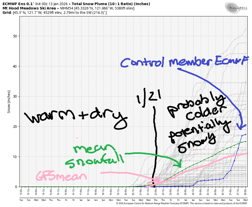
Hey skiers and snowboarders! Junuary – sunshine and warm temps – is in full swing on Mt Hood, and it’ll stick around through at least the 21st of this month. Beyond that, models hint at cooler weather and potential snowfall. While there’s quite a bit of range in the snowfall predictions, the mean is only 10-12” by the 29th of January, and the mode is lower. Glancing at the spaghetti snowfall model, I’d guess the median is also around 10”. Go ahead and cross your fingers for one of the outlier solutions calling for more snow, please!
Short term Mt Hood snow forecast
Tuesday will be sunny all day. The free air freezing level (FAF) will be above 10,000′ and temps at 5000′ will max out in the low 50s. Yes, you read that right. Wind will be light and variable all day long. Waxing? You’ll probably want a universal today as the snow will vary wildly depending on sun exposure.
Wednesday will be sunny. The free air freezing level will hold above 10,000′, and temps at 5000′ will be in the low-mid 50s. WARM! Expect light and variable wind all day becoming E 15mph overnight.
Extended Mt Hood Snow Forecast
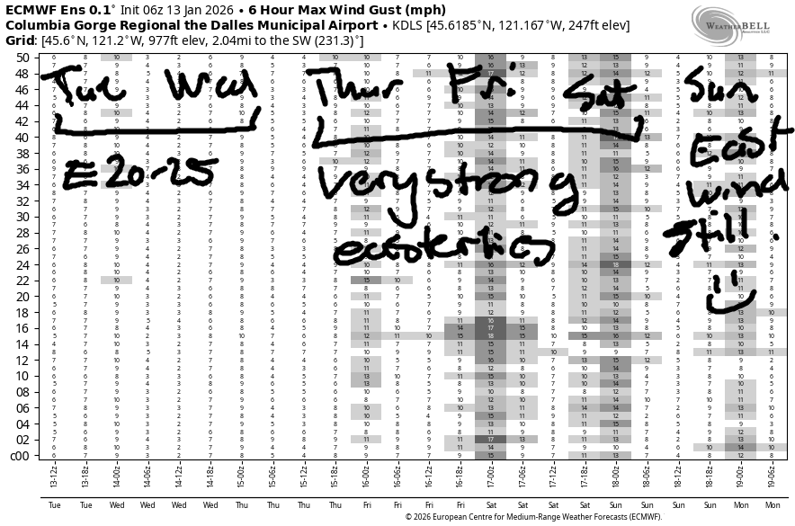
A pool of colder air settles in on the east side of the region on Thursday, and this drives increasing east wind and somewhat cooler temps. That said, you’ll run into random pockets of cooler and warmer air. The free air freezing level will be above 10,000′ all day with east wind building from 15mph to 25mph. Temps at 5000′ will range from the upper 40s to the mid 50s. Friday looks very similar. Saturday and Sunday: also sunny, also warm, but somewhat less windy. It is worth mentioning that the Thursday-Friday time period will see the easterlies pouring over the Cascade crest as well, which could lower speeds on the river somewhat. Still… it should be plenty windy.
As I mentioned at the start of this forecast, precipitation of some sort returns somewhere in the January 20-23 window. Models do suggest temps will be cold enough for snow, but they’re not optimistic about us getting lots of snow by the end of the month. Might as well turn on your spring skiing brain and enjoy the snow we have. If you don’t yet skate ski, consider taking a lesson – low snow years like this one has been so far make for excellent skate ski conditions. See you on the snow!
Was that helpful? I knew it was! Guess what? All of this crucial work – from your personal wind and snow reports to the invaluable TATAS updates – is made possible by my relentless efforts. Maintaining this labor of love isn’t easy. Each daily forecast takes hours. Website hosting, weather model access, and back-end admin work takes time and money. That’s where you come in.
YOUR CONTRIBUTION MAKES A DIFFERENCE
- SUPPORT ACCURATE, HYPER-LOCAL WEATHER FORECASTING
- ENABLE ACCESS FOR ALL, EVEN THOSE WITH LESS MEANS
- SUPPORT A COOL HUMAN WHO WORKS HARD SO YOU CAN PLAY
Take a moment to click one of the buttons below. Donate $19.99 or more (how much does this forecast enhance your life?) and get the email in your inbox. Whether it’s a renewing subscription (auto-renew) or a one-time donation, every contribution makes a real difference. Help me keep this labor of love alive, so we can all continue playing, commuting, and living in the Gorge with peace of mind and the best weather forecasts possible. Thank you!


Hood River, Oregon 97031


GORGE WIND FORECAST
If you’re still seeing yesterday’s and it’s after 9am, try opening this in an incognito window
SHORT-TERM gorge wind forecast
Hi friends! Well, so much for the chance at west wind, but we have lots of chances for easterlies coming up. And not just any old east wind. It should be quite strong between Thursday and at least Saturday.
Tuesday started with pressures of 30.39/30.43/30.37 and light easterlies in the western Gorge and light westerlies in the eastern Gorge. By late morning, Stevenson and Iwash (Rooster) Rock pick up to 20-25mph, perhaps 30mph at times. 25Mph holds through sunset. River flow over the last 24 hours was 180-204kcfs, river temp is 43.0F, and high temp forecast is 53F with clearing sky.
RIVER FLOW FOR SITES BETWEEN AVERY (EAST OF THE DALLES) AND RUFUS: CLICK HERE FOR JOHN DAY DAM FLOW.
RIVER FLOW FOR SITES BETWEEN STEVENSON AND DOUG’S BEACH (WEST OF THE DALLES): CLICK HERE FOR THE DALLES DAM FLOW

LONGER-TERM gorge wind forecast
Wednesday starts with 20-25mph at both Stevenson and Iwash. Midday sees the wind drop to 15-20mph at Stevenson and 10mph at Iwash. High temp: 52F with Nothing in the morning and sunshine in the afternoon. Head to the windy zones for sun earlier in the day.
Cooler air starts to pool in the desert on Thursday while very warm temps aloft lead to a Junuary heat low out near the coast. Easterlies start at 30-35mph near Stevenson and Iwash. By afternoon, Stevenson picks up to 35-40mph. Iwash ends the day at 45-50mph. Friday and Saturday look similar – very strong easterlies, Nothing cloud in Hood River, sunshine in the windy zones and on the mountain, and high temps in the low to mid 40s. Somewhat lesser east wind is forecast on Sunday, but it’ll still be strong. Dress warmly, and keep an eye on your buddies.
BARE BONES HOOD RIVER WEATHER FORECAST
Clear sky this morning. Temps start in the low 30s and rise to the low 50s. Light easterlies. No rainbows. Wednesday starts Nothing and ends sunny. Temps start in the mid 30s and rise to the low 50s. Light easterlies. No rainbows. Thursday will be Nothing then partly Nothing. Temps start in the mid 30s and rise to the upper 40s. Light to moderate easterlies. No rainbows.
TEMIRA’S AWESOME TRAVEL ADVISORY SERVICE
HYPERLOCAL WEATHER FORECAST FOR THE COLUMBIA GORGE
THE DALLES, HOOD RIVER, WHITE SALMON, TROUT LAKE, STEVENSON, CASCADE LOCKS, PARKDALE, ODELL, HUSUM, BZ, MILL A, WILLARD, GOLDENDALE, RUFUS, ARLINGTON, boardman
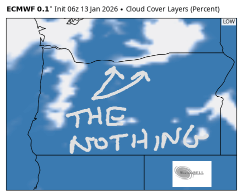
Good morning, neighbors! According to Mark Nelsen, we’re smack dab in the middle of the warmest winter ever for our region. Sad. If you look out the window this morning, and if you’ve been paying attention for the last few days, you’ll have noticed that we’re languishing in Juneuary. My rose bushes (and my bush) have started putting out new growth. We’ll stick with some version of Juneuary until at least the 20th of this month, but you may have to go up in elevation or east to find the “June” part of this later this week when the Nothing settles in…
Glenwood this morning and the ¡CE report
Looking around the region this morning, we see Glenwood FINALLY doing what Glenwood is supposed to do: it’s 27F there and warmer everywhere else. In an interesting twist, lower areas of Parkdale are reading 30F, upper areas are reading 39F, and Middle mountain is blazing hot at 47F. Yup. We have an inversion. It appears that the warm temps have melted all the ¡CE – no sign of them this morning. Perhaps they’re all in MN?
Today’s Gorge weather forecast
Today’s weather will be sunny with a few high clouds. Temps start between 27F and 47F (what a range!) and climb to the low 50s all the way up to the ski slopes. Most of us get light wind, but Stevenson, Cascade Locks, Iwash, and Home Valley get easterlies at 25mph by late morning.
Wednesday Gorge weather forecast
Clear sky overnight allows The Nothing to develop for Wednesday morning. Freezing fog and frosty roads are likely in the Nothing zone early. By afternoon, the west side clears out, and the Nothing partially dissipates east of the Cascade crest. Morning temps: all over the place, but averaging in the mid 30s. Afternoon: low 50s west and central, mid 40s east of The Dalles. Wind will be E 20-25mph in the usual spots early and 20mph later.
Extended Gorge weather forecast
Cooler, but not particularly cold, air settles in the desert on Thursday. Nothing lingers all day long in the desert. Nothing partially persists east of Home Valley all day. From Home Valley westward, strong east wind (30-50mph) breaks up the Nothing and allows the sun to shine. Other areas of the Gorge, in particular up in the hills, see east wind at 10-20mph. Friday and Saturday look just like Thursday. Sunday also looks similar with somewhat lesser east wind.
This pattern lingers well into next week; our next chance of precip arrives somewhere between the 20th and 23rd of the month. It’s likely this precip will arrive from the NW, which means it’ll likely be snow in the mountains. It’s possible, but far from guaranteed, that we could see lowland snow when we finally escape this (99th percentile) ridge of high pressure. No promises – models have way too much uncertainty to make any real predictions from this far out. Let’s wait until we know when the ridge will lessen its hold and then revisit. Safe travels. -TATAS
HEY! DON’T STOP READING! Is this community-focused forecast helpful to you? It sure is! It takes me a couple hours a day to write. Please join your friends and neighbors in contributing to keep it going. Venmo: @thegorgeismygym PayPal: twomirrors@gmail.com USPS: Temira / PO Box 841 / Hood River, Oregon 97031 You can test out the forecast subscription for a few days for free by signing up below. Easy! Do it!
JONES BEACH, SAUVIE ISLAND, & COAST FORECAST
ON WINTER VACATION UNLESS DESPERATELY NEEDED.
