

MT HOOD SNOW FORECAST

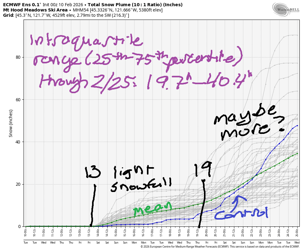
Hey skiers and snowboarders! There might not be a ton of new snow on Mt Hood, but it sure looks prettier than it did before the recent snowfall! Upcoming: a mild, but cool, week of dry weather with a shift to light snowfall on Friday afternoon. Models give us 3-7” total snowfall through the weekend, light snowfall next week, and then the potential for heavier snow starting around the 19th. Please do cross your fingers – it seems like these long-range forecasts have been erring optimistic this year. Intraquartile range between now and 2/25 is 19.7” to 40.4”.
Short term Mt Hood snow forecast
Tuesday started with some high clouds above the slopes. Some high cloud coverage will stick around today, but we should have filtered sun despite this. The free air freezing level will be 2500′ early, 4000′ this afternoon, 3500′ in the evening, and 5500′ after midnight. Temps max out in the low 30s at 5000′. Wind will be SSE 20 this morning, E 20-25 this afternoon, and E 15 overnight.
Wednesday will be sunny. The free air freezing level starts at 5500′, rises to 6000′, and holds there through the night. Temps at 5000′ top out in the mid 30s. Wind will be E 15 in the morning, S 5-10 in the afternoon, and W 10 overnight. Thursday starts clear, adds high clouds, and turns clear again in the evening. The free air freezing level starts around 6000′ and slowly falls to 5000′. Wind will be W 10-15mph all day long.
Extended Mt Hood Snow Forecast
The pattern FINALLY shifts to cooler/wetter on Friday. Most of the day looks dry and cloudy. Snwo arrives by early evening. The freezing level in the morning will be 5000′, but it’ll be down to 3500′ by the time snow starts falling. We’re expecting 2-3” of new snow by Saturday morning with wind at WSW 25-30mph. Light snow continues Saturday and Sunday (wind: nothing to worry about) with the total reaching 3-7” by Monday morning.
Beyond that: light snowfall through next week with heavier snowfall possible late in the week. That’s really too far out to be making predictions – the ensembles agree with this by offering up a huge range of total snowfall: 19.7” to 40.4” through the 25th of the month. Vote for the high end of that, please! And in the meantime, get yourself some snow sports rather than no snow sports! The mountains are calling – go play!
Was that helpful? I knew it was! Guess what? All of this crucial work – from your personal wind and snow reports to the invaluable TATAS updates – is made possible by my relentless efforts. Maintaining this labor of love isn’t easy. Each daily forecast takes hours. Website hosting, weather model access, and back-end admin work takes time and money. That’s where you come in.
YOUR CONTRIBUTION MAKES A DIFFERENCE
- SUPPORT ACCURATE, HYPER-LOCAL WEATHER FORECASTING
- ENABLE ACCESS FOR ALL, EVEN THOSE WITH LESS MEANS
- SUPPORT A COOL HUMAN WHO WORKS HARD SO YOU CAN PLAY
Take a moment to click one of the buttons below. Donate $19.99 or more (how much does this forecast enhance your life?) and get the email in your inbox. Whether it’s a renewing subscription (auto-renew) or a one-time donation, every contribution makes a real difference. Help me keep this labor of love alive, so we can all continue playing, commuting, and living in the Gorge with peace of mind and the best weather forecasts possible. Thank you!


Hood River, Oregon 97031


GORGE WIND FORECAST
If you’re still seeing yesterday’s and it’s after 9am, try opening this in an incognito window
SHORT-TERM gorge wind forecast
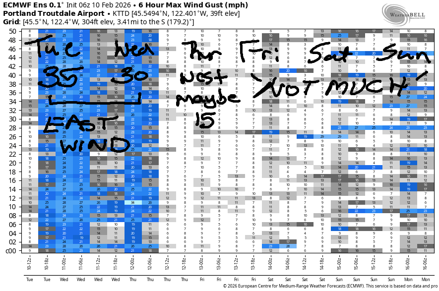
Hi friends! East wind today and tomorrow is followed by a round of light westerlies on Thursday. Models have light/variable wind on Friday and Saturday as a somewhat more active weather pattern makes our wind dependent on the vagaries of passing low pressure systems. If we get really lucky (ensembles are not optimistic), we could see a west wind day on Sunday.
Tuesday started with pressures of 30.07/30.16/30.17. East wind was reading 30mph at Iwash/Rooster and 20mph at both Stevenson and Viento. The wind bumps up about 5mph mid-morning before leveling out at 25mph at both Stevenson and Iwash this afternoon. East of Viento, the wind builds to 5-15mph this afternoon in response to the synoptic-scale pattern that has a heat low positioned over the coast. River flow over the last 24 hours was 124-182kcfs, river temp is 41.2F, and high temp forecast is 47F with sunshine.
RIVER FLOW FOR SITES BETWEEN AVERY (EAST OF THE DALLES) AND RUFUS: CLICK HERE FOR JOHN DAY DAM FLOW.
RIVER FLOW FOR SITES BETWEEN STEVENSON AND DOUG’S BEACH (WEST OF THE DALLES): CLICK HERE FOR THE DALLES DAM FLOW

LONGER-TERM gorge wind forecast
Wednesday starts with 30-35mph at Iwash/Rooster and 20-25mph at Stevenson. The wind holds through late morning and then drops to 25mph at Iwash and 15-20mph at Stevenson. High temp will be 49F with sunshine, even away from the windy zones, at least in the afternoon.
Thursday sees a weak weather system swing through. It does little more that add some clouds and turn the wind onshore; we’ll start the day calm and build to gusty 14-17mph from Stevenson to The Dalles with 10-13mph at Rufus. High temp: 50F under cloudy sky. Friday and Saturday both look calm or nearly so (at least for now) as weak systems bring showers and colder air. We might get lucky and see a (chilly) west wind day on Sunday if a low pressure system behaves just right. Have a great day, everyone!
BARE BONES HOOD RIVER WEATHER FORECAST
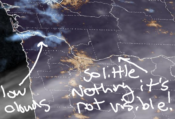
Nothing this morning with areas of fog. High clouds later. Temps start in the mid 30s and rise to the upper 40s. Light easterlies, moderate in the hills. NO rainbows. Wednesday will be partly Nothing then clear. Temps start in the mid 30sa and rise to nearly 50. Light easterlies. No rainbows. Thursday will be partly Nothing then cloudy. Temps start in the mid 30s and rise to 50. Calm wind early. Light westerlies later. No rainbows.
TEMIRA’S AWESOME TRAVEL ADVISORY SERVICE
HYPERLOCAL WEATHER FORECAST FOR THE COLUMBIA GORGE
THE DALLES, HOOD RIVER, WHITE SALMON, TROUT LAKE, STEVENSON, CASCADE LOCKS, PARKDALE, ODELL, HUSUM, BZ, MILL A, WILLARD, GOLDENDALE, RUFUS, ARLINGTON, boardman
Good morning, neighbors! Another unobtrusive week of weather is on tap. You may not even notice that weather is happening. Starting Friday, cooler temps combine with precipitation for a wetter version of unobtrusive weather. It’s possible our higher elevations could see a little snow next week, and it’s likely we’ll see icy roads mixed in over the weekend for a few folks, but all-in-all, not much to worry about in the near-term future.
Glenwood and today’s Gorge weather forecast
Glenwood has stopped worrying at all this morning and is celebrating their dominance: it’s 24 degrees and sunny there this morning. A wide variety of temps are present around the Gorge to start Tuesday: mid to upper 20s where it’s clear, 30-something where the Nothing is present,and upper 30s in the windy zones. Models insist that the Nothing will burn off today – it’s limited to the near-river spots early – leaving us with sunshine or filtered sunshine and a few high clouds. Afternoon temps rise to the upper 40s in the lowlands. Up in the mountains: low 30s this afternoon. This lack of inversion makes it more likely the Nothing will dissipate. Today’s wind will be E 30mph near Iwash, E 25mph near Stevenson, and E 10-15mph elsewhere in the afternoon.
Wednesday’s Gorge weather forecast
Overnight, mostly clear sky allows many folks to drop below freezing. Yet another minimal-coverage (about as much as a banana hammock) Nothing starts Wednesday near the Nch’i Wana (Big River). That Nothing quickly burns off, leaving the Gorge completely unclothed and exposed to full-on sunshine and 50ish degrees. Easterlies stick around: 35mph near Iwash in the morning with 25mph in the afternoon. Stevenson: 25mph in the morning and 15-20mph in the afternoon.
Thursday’s Gorge weather forecast
Another partial Nothing is forecast Thursday, but it’s quickly replaced by mid and high clouds that stretch all the way out in to the desert. Despite this, we’re still expecting high temps near 50F after a low-mid 30s start. Wind will be calm in the morning and west 15mph in the afternoon.
Extended Gorge weather forecast
Something more interesting happens on Friday afternoon or evening: a little rain. “A little rain” continues on and off through the weekend. As of this morning, the snow level stays above 2500′ through Sunday daytime. Sunday night sees it fall as low as 1000′. While there won’t be all that much moisture, the possibility of a little snow exists for some of you. We’ll explore that more as we get closer. Cool, intermittently showery weather is forecast next week. See: nothing to be worried about here. No floods. No ice storms. No big dumps (unless you eat lots of fiber). All we have is the potential for a bit of slippery frost on the roads in and above the Nothing this week. Safe travels. -TATAS
HEY! DON’T STOP READING! Is this community-focused forecast helpful to you? It sure is! It takes me a couple hours a day to write. Please join your friends and neighbors in contributing to keep it going. Venmo: @thegorgeismygym PayPal: twomirrors@gmail.com USPS: Temira / PO Box 841 / Hood River, Oregon 97031 You can test out the forecast subscription for a few days for free by signing up below. Easy! Do it!
JONES BEACH, SAUVIE ISLAND, & COAST FORECAST
ON WINTER VACATION UNLESS DESPERATELY NEEDED.
