

GORGE WIND FORECAST
today’s gorge wind forecast
Hi friends! There was just enough east wind yesterday for a nice tailwind riding bikes back from The Dalles. It’s peak lupine on Sevenmile right now – if you have time, check it out! You’ll have the opportunity today for non-wind sports such as road biking as easterlies barely touch the usable zone. Strong westerlies are in the cards for Wednesday. We could see just enough wind late Friday for some of you to get on the river. Ensembles give us a forecast for somewhat stronger westerlies for the weekend. Beyond that: quite a bit of uncertainty with some hints of another Wednesday blow next week.
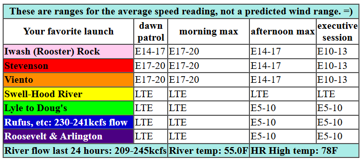
Taking a look at Tuesday… we kick it off with pressures of 30.10/30.15/30.16 for light offshore gradients. Models insist we’ll see 17-20mph today at both Stevenson and Iwash (Rooster) with 15-18ish at Viento. That lasts for a few hours late morning and fades to 10-15mph this afternoon. East of Viento, the wind rises to E 5-10 this afternoon. River flow over the last 24 hours was 209-245kcfs (230-241kcfs at Rufus), river temp is 55F, and high temp forecast is 78F with increasing high clouds.

tomorrow’s gorge wind forecast
A trough moves inland on Wednesday and leaves us with moderately strong offshore high pressure and perhaps 10 degrees of cross-Cascade temp gradient. The GFS is trending a lot stronger than the Euro ensembles (which have backed off a little) for the day, but it still looks plenty windy. Dawn Patrol opens the day with 17-20 from Stevenson to Hood River and 10-13 east of Hood River to Arlington. By late morning, we’ll have 24-27 from Stevenson to Arlington. Areas from Mosier eastward shine in the afternoon with 27-31 (Euro ensembles) or a bit more. Strongest zone will be Lyle to Rufus. As clouds push in from the west late afternoon, the wind falls to gusty 21-25 between Stevenson and the cloud line, which could be Hood River or Mosier. High temp: 74F with partly cloudy sky.
extended Gorge wind forecast
Gradients collapse to near-nothing on Thursday. The day starts with light westerlies, less than 10mph. Everything goes calm midday. Westerlies return at 10-13mph from Stevenson to Mosier in the evening with calm wind to the east. High temp: 71F and partly high overcast. Somewhat stronger west wind, perhaps 15-18mph, is forecast from Stevenson to Mosier for Friday afternoon.
Looking deeper into the future… the Euro ensembles have moderately strong wind for both Saturday and Sunday followed by lesser westerlies Monday and the potential for a couple more days of somewhat stronger wind next Tuesday and Wednesday. About 75% of the ensemble members are in for a big day next Wednesday, but that’s really far out to be making any sort of reliable prediction. But hey, we can dream, can’t we? Maybe Wednesday’s our day this year! See you on the river!
Was that helpful? I knew it was! Guess what? All of this crucial work – from your personal wind and snow reports to the invaluable TATAS updates – is made possible by my relentless efforts. Maintaining this labor of love isn’t easy. Each daily forecast takes hours. Website hosting, weather model access, and back-end admin work takes time and money. That’s where you come in.
YOUR CONTRIBUTION MAKES A DIFFERENCE
- SUPPORT ACCURATE, HYPER-LOCAL WEATHER FORECASTING
- ENABLE ACCESS FOR ALL, EVEN THOSE WITH LESS MEANS
- SUPPORT A COOL HUMAN WHO WORKS HARD SO YOU CAN PLAY
Take a moment to click one of the buttons below. Donate $19.99 or more (how much does this forecast enhance your life?) and get the email in your inbox. Whether it’s a renewing subscription (auto-renew) or a one-time donation, every contribution makes a real difference. Help me keep this labor of love alive, so we can all continue playing, commuting, and living in the Gorge with peace of mind and the best weather forecasts possible. Thank you!


Hood River, Oregon 97031


JONES BEACH, SAUVIE ISLAND, & COAST FORECAST
Wind northerly unless otherwise indicated. For coast, it’s North/Central/South with the “central” at approximately Florence. Swell forecast from NWS for central coast. Tuesday: NW10/N15/N20-25, W swell 5′ at 13 seconds. Wednesday: NW15/N15-20/10-15, W 5′ @ 12. Thursday: 15-20/20-25/25, W 6′ @ 12. Jones Tuesday: LTW. Wednesday: LTW. Thursday: 13-16. Sauvie Island Tuesday: LTV. Wednesday: 16-19. Thursday: 10-13.
BARE BONES HOOD RIVER WEATHER FORECAST
Clear sky this morning adds high clouds later. Temps start near 40 and rise to the upper 70s. Light easterlies. No rainbows. Wednesday will be partly cloudy then mostly cloudy late. Temps start in the upper 40s and rise to the mid 70s. Moderate westerlies early. Strong westerlies later. No rainbows. Thursday will be partly high cloudy. Temps start in the low 40s and rise to the low 70s. Light westerlies, calm midday. No rainbows.
TEMIRA’S AWESOME TRAVEL ADVISORY SERVICE
HYPERLOCAL WEATHER FORECAST FOR THE COLUMBIA GORGE
THE DALLES, HOOD RIVER, WHITE SALMON, TROUT LAKE, STEVENSON, CASCADE LOCKS, PARKDALE, ODELL, HUSUM, BZ, MILL A, WILLARD, GOLDENDALE, RUFUS, ARLINGTON, boardman
Good morning, neighbors! It’s another gorgeous day here in the Gorge. If you’ll excuse me for a moment, I have to go take a photo and express my gratitude to the sun for rising. I’ll be right back.
Okay. I’m back. In case you were wondering, here’s my morning gratitude to Sol: “Thank you, sun, for rising this morning so we didn’t all freeze into blocks of ice. And thank you for being not too hot and not too cold so life exists on this planet. And thanks for not going supernova last night and burning us all to a crisp. I hope you have a good day circling the planet and you see lots of acts of kindness.” Then I bow and get back to work. Gratitude is a good way to start the day. I recommend it.
I almost forgot Glenwood. It was 31 degrees there this morning.
today’s gorge weather forecast
If you like sun, you’ll have plenty of time to be grateful today. High clouds move in this afternoon from the west and make it to maybe Hood River or Mosier. If we can get a gap in those clouds at sunset – 8:20pm – we’ll have a colorful one. Temps max out near 80 today in the lowlands. East wind picks up to 15-20mph near Iwash (cock) Rock and Stevenson with 5-10mph east of Viento and 15mph in the hills.
wednesday’s gorge weather forecast
Weather stuff happens overnight and into tomorrow resulting in slightly cooler, definitely cloudier, and much windier conditions for Wednesday. You’re not going to freeze your buttocks off by any means, but you might want a T-shirt rather than no shirt. Notable on Wednesday: the wind. Westerlies start at 15-20mph from Stevenson to Hood River with 10mph to the east. By afternoon, we’ll have 30mph or so all the way from Stevenson to Arlington, strongest between Lyle and Bob’s Texas T-Bone (the location formerly known as Rufus). Clouds move in from the west in the afternoon and leave us partly cloudy all the way out east even in the desert. Some drizzle is possible west of Wyeth between 5pm and 8pm. Please, for the love of everything that’s beautiful around here, make sure your burn piles are extinguished and take great care when mowing. I don’t know if the fire east of The Dalles yesterday was intentional (field burning or some such) or accidental, but let’s not test the dryness of things on Wednesday, okay? High temp: 74F.
Extended Gorge weather forecast
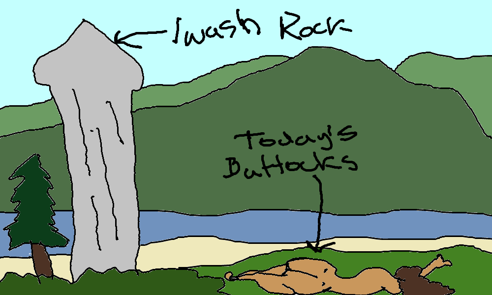
Thursday looks a little cooler, a lot calmer, and will be a great day to tan your buttocks at Iwash (dick) Rock. You were waiting for today’s butt reference, weren’t you? Beyond Thursday… a couple warmer days followed by a 5-7 day stretch of somewhat cooler weather, perhaps even a couple of degrees below normal. Normal is mid-60s this week. We also have a decent shot at a little rain, maybe all the way east to The Dalles (currently about a 60% chance of rain that far east), to start next week. As for gardening… my garden looks like mid June already. How are y’alls gardens in the higher elevations? Safe travels. -TATAS
HEY! DON’T STOP READING! Is this community-focused forecast helpful to you? It sure is! It takes me a couple hours a day to write. Please join your friends and neighbors in contributing to keep it going. Venmo: @thegorgeismygym PayPal: twomirrors@gmail.com USPS: Temira / PO Box 841 / Hood River, Oregon 97031 You can test out the forecast subscription for a few days for free by signing up below. Easy! Do it!
