

MT HOOD WEATHER FORECAST
Hey skiers and snowboarders! It’s a chilly morning up on the slopes. Temps range from -3F at Meadows Nordic to the single digits on the ski slopes at the lift-serve resorts. If you’re riding today, consider cleaning and re-waxing your bases with a wax designed for cold temps and very low humidity. You’ll be very glad you did! We’ll stick with cold, sunny weather for a couple days, and then we’re back to clouds and snow starting Thursday. Snow amounts have been trending downward for the Thursday-Friday time frame, but temps have been trending downward for the next system on Sunday (yesterday we were talking mixed precip, and now we’re talking snow). So, let’s see what we’ve got!
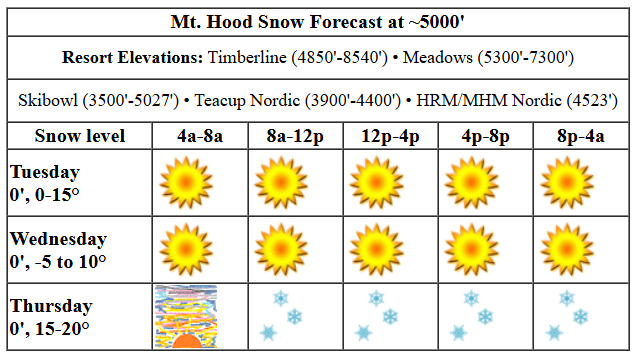
Wax blue for whatever you’re doing on the slopes today, and you’ll have a faster, more slidey experience. Snow conditions: packed powder and hardpack. We’ll have sun all day with the free air freezing level hovering at 0′. Temps max out in the low double digits at 5000′. Wind will be E 20 all day and will fade to E 15 after midnight. Wednesday also looks sunny with the freezing level at 0′. Temps start bitterly cold, perhaps below zero F, and they rise to the upper teens. Wind: E 15 in the morning, SE 15-20 in the afternoon, and S 15-25 after midnight.
The next system comes in from the S on Thursday, but the low sending it our way has been trending farther south. This means less snowfall than previously anticipated. The snow level will be 0′ all day long with temps in the teens to start and low 20s to finish. Light, steady snowfall starts mid-morning and picks up in the evening. Just 1-2” new snow is forecast. Wind will be S 15-25 all day and will fade to SW 10-15 overnight.
Light snowfall continues on Friday with the effective snow level (based on temps) at 500-1000′ in the morning, 2000′ in the afternoon, and 500-1000′ overnight. Near Mt. Hood and in the Gorge, the snow level will be 0′ thanks to tons of cold air piled up on the east side. About 0.2” water equivalent (WE) is forecast during the day for 2-3” dry powder. Another 0.1” WE is forecast overnight, for another inch of new. Wind: SW 5-10 in the morning, W 20 in the afternoon, and W 25 overnight.
Saturday looks dry. Sunshine early, clouds later. Snow might or might not come in overnight. Temps will be near 20 to start and in the upper 20s in the afternoon and night. Wind: W 25 turning to SW 15-30. Models are bouncing around a fair bit for Sunday, but it currently looks like we’ll see relatively warm temps and dense, heavy snowfall. Fingers crossed, cuz that’s way preferable to rain or mixed precip. Stay tuned. See you on the snow!
Liking this forecast?
Was that helpful? I knew it was! Guess what? All of this crucial work – from your personal wind and snow reports to the invaluable TATAS updates – is made possible by my relentless efforts. Maintaining this labor of love isn’t easy. Each daily forecast takes hours. Website hosting, weather model access, and back-end admin work takes time and money. That’s where you come in.
YOUR CONTRIBUTION MAKES A DIFFERENCE
- SUPPORT ACCURATE, HYPER-LOCAL WEATHER FORECASTING
- ENABLE ACCESS FOR ALL, EVEN THOSE WITH LESS MEANS
- SUPPORT A COOL HUMAN WHO WORKS HARD SO YOU CAN PLAY
Take a moment to click one of the buttons below. Donate $19.99 or more (how much does this forecast enhance your life?) and get the email in your inbox. Whether it’s a renewing subscription (auto-renew) or a one-time donation, every contribution makes a real difference. Help me keep this labor of love alive, so we can all continue playing, commuting, and living in the Gorge with peace of mind and the best weather forecasts possible. Thank you!


Hood River, Oregon 97031


GORGE WIND FORECAST

Hi friends! It’s going to be windy the next several days, but with temps hovering at or below freezing, getting out on the river is a very bad idea. There are plenty of other awesome things to do in this kind of weather. For knowledge purposes only, here’s the forecast: Tuesday brings easterlies at 25mph at both Stevenson and Iwash (Rooster) Rock all day long. East of Viento, the wind picks up to 10-15mph as well. River flow over the last 24 hours was 82-153kcfs, river temp is 38.66F, and high temp forecast is 32F and sunny all day.
Wednesday starts with east wind at 50mph at Iwash and 25mph at Stevenson. The wind rises to 40mph both places, holds at Iwash, and drops to 25-30mph at Stevenson late afternoon. East of Viento: easterlies at 15mph. High temp: 31F and sunny. Thursday kicks off nuking: 50-60mph at Iwash and 40-45mph at Stevenson with temps in the 15-20 degree range giving us a wind chill of -11F. In the afternoon, the wind drops to 35mph at Stevenson and 50mph at Iwash. East of Viento: 10-15mph. High temp: 27F and cloudy with light snowfall from mid-morning on. Models are all over the place on Friday. The day starts easterly but may switch to westerly. Maybe. Stay tuned. And please stay off the river the next three days – it’s not safe. Go for a hike and see the frozen waterfalls instead.
BARE BONES HOOD RIVER WEATHER FORECAST
Clear and cold today with temps near 20 early and right at freezing later. Light to moderate easterlies. No rainbows. Wednesday will be partly Nothing then clear. Temps start in the low double digits and rise right near freezing. Moderate easterlies. No rainbows. Thursday starts cloudy and adds light snowfall. Maybe 1” total. Temps start in the teens and rise to the upper 20s. Moderate easterlies. No rainbows.
TEMIRA’S AWESOME TRAVEL ADVISORY SERVICE (HYPERLOCAL FORECAST FOR THE COLUMBIA GORGE)
Good morning, neighbors! As forecast, it’s cold AF this morning. I received a photo of a Glenwood-based thermometer showing … wait, we’ll talk about that in the “Glenwood” section of the forecast. That meets criteria for NWS’ “Extreme Cold Warning”, and indeed, NWS Portland has issued an “Extreme Cold Watch” for the western Gorge for tonight. The lack of such warning for the rest of us is merely an oversight by NWS Pendleton, as criteria will be met. Extreme cold continues until Thursday morning when we switch to light snowfall. Snow continues through Friday. Much more interesting weather is possible Sunday when models have a much wetter system headed this way.
In the meantime, you should totally dress super warm and check out the frozen waterfalls along the I-84 (I-MgClNaCl) corridor. Other fun things: go watch the wind at Iwash Rock on Wednesday and Thursday morning. Speak sweet nothings to the ponds along the Nch’i Wana and encourage them to freeze so we can ice skate in town. Also make a huge vat of chicken stock and put it outside; chicken thighs and legs are “buy 1 get 2 free” at Freddies. Which begs this question: “If we are culling chicken flocks because of bird flu and egg prices are through the roof due to limited supply, why haven’t chicken flesh prices risen too?”
glenwood
On to Glenwood, as I know you’ve been waiting with bated breath: -8F to -5F there this morning! And next, the TATAS executive order of the day: “All youth shall be eligible for two free years of community college or two free years of trade training. All internships shall be paid at minimum wage or better with benefits equal to those given to employees.” Signed in the same cheap crappy pen that I used to sign up for a 9 month unpaid counseling internship.
today (tuesday)
On to the weather: it’s FUCKING GLORIOUS out there this morning. There’s something about a cold, low-humidity winter day that makes me real happy. I’ve been informed that this is “Minnesota Weather”, which means you should have tuna casserole and jello salad for dinner with chocolate chip cookies for dessert.
But let’s note that pipes will be freezing, and our unhoused neighbors will be cold, potentially deathly cold. Protect your property, and check on elders and other vulnerable folks who could use a hand protecting themselves and their property. Temps today max out around 32F in the lowlands, colder in the hills, and the breeze will make it feel colder: easterlies will be 25mph near Iwash/Stevenson, and 10-15mph west of Hood River and in the hills, SW, and generally all over the place.
Temps plummet tonight.
wednesday
If you thought this morning was cold, wait until tomorrow. Lowlands will be below 15 degrees, and many of you in outlying areas will be in the single digits or even below zero. Thank a very deep cold pool with temps at -16C aloft. We could start with some partial Nothing along the Big River, but the sky will quickly clear. Temps probably won’t climb above freezing. Easterlies will be 50mph near Iwash and 30-40mph near Stevenson all day. East of Viento, we’ll have easterlies at 15mph, potentially stronger along the east side of the Cascade foothills (Dufur, for example). Brrrrrr. Want to see something rare and pretty? Go check out the frozen waterfalls.
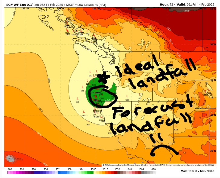
thursday
Another bitterly cold night is forecast Wednesday night into Thursday. We all wake up to teens and cloudy sky on Thursday. Not teenagers, mind you. Waking up to a grumpy teenager is nearly as bad as waking up to temps at 15 degrees. Light snowfall arrives mid-morning, heaviest to the south. Sadly, the low initially forecast to make landfall near Oceanside is now forecast to make landfall just north of Pistol River or even in NoCal. The farther south it lands, the less snow we see. Vote for Oceanside landfall if you have a moment. And also call every one of your representatives and express your concern about separation of powers, executive overreach, and the threats of deportation to your neighbors and coworkers. Snow for Thursday: As of this morning, we’re only looking at an inch or so for Thursday, but hey, at least it will extend all the way east to Arlington! With 50-60mph east wind at Iwash and 10-15mph wind east of Viento, we’d be looking at Blizzard criteria for the western Gorge IF ONLY THERE WERE MORE SNOW COMING. Alas.
Maybe I don’t have to say this, but… stay the heck away from the Valley of Willies (metro area and south and north) on Thrusday. With even a trace of snow or ice, it’ll be a poop-show.
friday and beyond
Light snowfall continues on Friday with another trace to a couple inches forecast. Models cannot decide if a low moving inland will be enough to turn the flow onshore and clear out the cold air. Let’s go with “probably not” as our initial condition for the weekend knowing that a “west wind on Friday” scenario results in a different weekend forecast.
With that initial condition, we have a dry, chilly (but not frigid) day on Saturday. That’s followed by a much wetter day on Sunday. Previous model runs had 850mb temps (5000′ elevation) a couple degrees above freezing. Now those temps are hovering right around 0C. Thanks to that, depending on how much cold air is left in the Ditch, we could get by with snow, not freezing rain, out of this system if those 850mb temps stay at 0C or less. Based on this morning’s model run, I’m leaning towards snow, but I’m not promising the forecast will stay that way. If you are west of Mosier, prepare for the possibility of a significant winter storm on Sunday into Monday. Consider yourself lucky if we end up with cold rain instead. Stay tuned. Safe travels. -TATAS
HEY! DON’T STOP READING! Is this community-focused forecast helpful to you? It sure is! It takes me a couple hours a day to write. Please join your friends and neighbors in contributing to keep it going. Venmo: @thegorgeismygym PayPal: twomirrors@gmail.com USPS: Temira / PO Box 841 / Hood River, Oregon 97031 You can test out the forecast subscription for a few days for free by clicking this link: https://subscribepage.io/YhevGc
