

MT HOOD WEATHER FORECAST

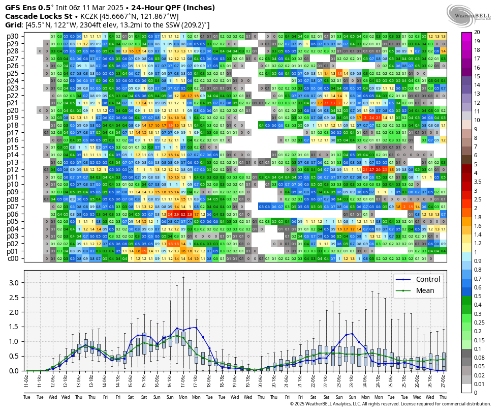
Hey skiers and snowboarders! Remember back in the good old days where March was the snowiest month? Well, it’s looking increasingly likely that we’ll see a version of that over the next week, especially from Friday on through the weekend. Ensembles give us 25-43” of snow at 5000′ by next Monday. Wow. Let’s dive in and see how likely this is, shall we?
Tuesday’s Mt Hood weather will be cloudy during the day with light snow overnight. The snow level starts around 1500′, rises to 4000′ this afternoon, and drops to 3000′ or so overnight. Temps will be near 30F this morning and 32-33F this afternoon. About 0.1” to 0.2” water equivalent (WE) arrives in the form of snow tonight for an inch or two of relatively dense new snow. Wind will be W 15 this morning, SW 5-10 this afternoon, and SW 15-25 overnight.
Temps are right on the edge Wednesday for snow/rain/mixed precip. While models have the snow level at 3000′ in the morning, 4000′ in the afternoon, and 1000′ after midnight, temps look marginal: 32F in the morning, 33-34F in the afternoon, and 28F overnight. Let’s call it snain (wet snow) above 4000′ with rain below for now. Models give us 0.1” to 0.2” WE during the day for an inch or two of fresh up high. Overnight, as the temp drops, the forecast contains 0.3” to 0.4” WE for 2-4” of increasingly dry snow. Wind will be SW 15-25 in the morning, SSW 10-15 in the afternoon, and W 30 overnight for some orographic assistance to the snowfall intensity.
Thursday looks interesting – we’ll be in a rather unstable atmospheric environment. This makes for unpredictable snowfall – it’s going to be an intermittently snowy day, but it’s not clear where the heaviest snow showers will pass. The snow level will be 1000′ early, 2000′ in the afternoon, and down around 1500′ overnight. Temps will be in the upper 20s all day. We could see up to 2” new snow during the day, or we could get unlucky and see none. Overnight: up to an inch of new. Wind: W 30 in the morning, WSW 15-20 midday, W 35 in the evening, and SW 10-20 after midnight.
A more stable setup arrives on Friday, but this one’s got snow with it. The snow level will be around 1000′ early, 2000′ in the afternoon, and 2000′ after midnight. As of this morning, models have 0.3” WE during the day for 3-4” powder. The also have 0.7” WE overnight for 6-8” fresh powder. Wind: SW 10-20 during the day, WSW 25-30 in the afternoon, and W 30 after midnight. Additional snow, up to half a foot, is forecast Saturday daytime. Ensembles (particularly the Euro), suggest very heavy precip from Saturday night into Sunday night – that’s where the bulk of the 25-43” total is possible. Speaking of possible, there’s also a decent chance of a period of mixed precip or snain during that period of intense precip. It really depends on the path of an incoming low. No matter what happens with that system, it does look like we’ll have quite a bit of fresh snow in the next week or so. Good! We need it! Have fun out there!
Was that helpful? I knew it was! Guess what? All of this crucial work – from your personal wind and snow reports to the invaluable TATAS updates – is made possible by my relentless efforts. Maintaining this labor of love isn’t easy. Each daily forecast takes hours. Website hosting, weather model access, and back-end admin work takes time and money. That’s where you come in.
YOUR CONTRIBUTION MAKES A DIFFERENCE
- SUPPORT ACCURATE, HYPER-LOCAL WEATHER FORECASTING
- ENABLE ACCESS FOR ALL, EVEN THOSE WITH LESS MEANS
- SUPPORT A COOL HUMAN WHO WORKS HARD SO YOU CAN PLAY
Take a moment to click one of the buttons below. Donate $19.99 or more (how much does this forecast enhance your life?) and get the email in your inbox. Whether it’s a renewing subscription (auto-renew) or a one-time donation, every contribution makes a real difference. Help me keep this labor of love alive, so we can all continue playing, commuting, and living in the Gorge with peace of mind and the best weather forecasts possible. Thank you!


Hood River, Oregon 97031


GORGE WIND FORECAST

Hi friends! Nothing happens in wind world today, but there’s a decent chance of wind somewhere on Wednesday and Thursday, despite the raininess and instability. Your next best chance for a steadier, stronger day is Sunday. Tuesday kicks off with pressures of 29.83/29.81 for a light onshore gradient. That disappears, and the wind goes calm. River flow over the last 24 hours was 95-159kcfs, river temp is 42.44F, and high temp forecast is 53F with clouds.
Wednesday starts calm. We’ll see a couple hours of E 10-15mph at Iwash (Rooster) and Stevenson in the morning. Expect westerlies in the afternoon, but they might not get strong enough until after dark. To start the day, we’ll have 10-13 from Rooster to Swell and Maryhill to Arlington. After 5pm, models hint at a chance of 17-20 from Stevenson to Doug’s with less east of there. It’ll also be rainy, so conditions will be both gusty and unreliable. High temp: 50F with clouds and wind.
There’s a better chance for wind on Thursday as a trough moves inland and high pressure briefly builds offshore. However… instability will be present, and that will definitely decrease wind quality. The day starts with less than 10mph west of Avery and gusty 19-22 from Maryhill to Boardman. Afternoon wind rise to gusty 22-26 from Avery to Arlington with gusty 15-18 from Stevenson to Doug’s. Expect intermittent rain showers all day with a possibility of hail and thunder. It’s not the greatest setup for wind, but there might be periods in the afternoon when you can get out there. High temp: 47F. As of this morning, Friday and Saturday look too light for wind sports. The next best chance for wind is Sunday. That really depends on the path of an incoming low pressure system. Ensembles are on board with westerlies, but the strength is far from certain. Have a great day out there!
BARE BONES HOOD RIVER WEATHER FORECAST
Clouds all day with rain this evening. Temps start in the mid 30s and rise to the low 50s. Calm wind. No rainbows. Wednesday will be rainy. Temps start near 40 and rise to 50. Calm wind early. Light westerlies later. 87% chance of rainbows. Thursday will be showery. Temps start in the upper 30s and rise to the upper 40s. Moderate westerlies. 99.9% chance of rainbows.
TEMIRA’S AWESOME TRAVEL ADVISORY SERVICE
HYPERLOCAL WEATHER FORECAST FOR THE COLUMBIA GORGE
THE DALLES, HOOD RIVER, WHITE SALMON, TROUT LAKE, STEVENSON, CASCADE LOCKS, PARKDALE, ODELL, HUSUM, BZ, MILL A, WILLARD, GOLDENDALE, RUFUS, ARLINGTON, boardman
Good morning, neighbors! We’re basically out of the coldest part of winter – the last record low below 10 degrees was 3/5, and the last below 20 degrees is 3/29 – but we’re not quite out of the woods for snow yet. We’ll have a test case on Friday. Know what else is still possible? Heavy rain. This weekend.
glenwood and the tatas eootd
But first, let’s check in with Glenwood. When I first woke up, it was 29 degrees there. Good job, Glenwood. Next up, the TATAS Executive Order of The Day: there shall be a cap on college costs (tuition and books) of 10% of the median (not mean, because that’s distorted) salary in the USA. Signed with a broken pencil found on the street, because that’s all most graduates can afford after being saddled with tens of thousands of dollars in loans.
today – it’s tuesday
On to the weather: cloudy today with drizzle this evening. Rain starts up late afternoon and quickly makes it as far east as The Dalles. By evening, the rain extends to Celilo, and overnight, it makes it to the Arlington Triangle, south Wasco, and Sherman County areas. Expect light rain, not a torrential downpour. High temp today: 53 degrees or so in the lowlands. Wind: basically calm.
wednesday
Wednesday will be rainy from sunrise to sunset for areas west of Mosier. After mid-morning, the rain picks up east of Mosier too. South Wasco and Sherman County will see intermittent drizzle in the morning and rain in the evening. Rain stops after midnight most places. Exception: areas east of Arlington look wet still. As temps drops overnight in response to incoming cold air, it’s possible our highest elevations could see a trace of snow and/or icy roads. Temps max out near 50 on Wednesday. Calm wind in the morning gives way to westerlies at 15-20mph in the afternoon as far east as The Dalles.
thursday
Thanks to instability in the atmosphere (that’s different than instability in the country), Thursday looks showery and full of rainbows. Snain (really wet snowflakes), hail, and graupel (rimed snowflakes) are all possible thanks to rising and falling air pockets. Those air like pizza pockets, but much less flavorful and with far fewer calories. Showers make it as far east, on and off, to Amayah’s Indian Curry and Kababs. High temp: 47F. West wind will be 10-20mph west of The Dalles and 20-25mph to the east.
friday and beyond…
We could see a little snow with the next system Friday morning if the sky clears enough Thursday night. Snow is most likely above 1000′. Don’t freak out. It’s probably just a little snow. We then transition to much wetter weather Friday evening into Sunday morning as an offshore low taps into deep moisture and sends lots of rain this way. Valuable Advice for Gardeners Inhabiting Neighboring Areas: get your bed prep done now if you can. Get some lettuce and peas and radishes planted. Get that manure into the garden and into the compost pile. Get it done before that weekend downpour arrives and the soil returns to a saturated state. If you garden in the lowlands, it’s time to start your tomatoes and peppers. Happy gardening. Safe travels. -TATAS
HEY! DON’T STOP READING! Is this community-focused forecast helpful to you? It sure is! It takes me a couple hours a day to write. Please join your friends and neighbors in contributing to keep it going. Venmo: @thegorgeismygym PayPal: twomirrors@gmail.com USPS: Temira / PO Box 841 / Hood River, Oregon 97031 You can test out the forecast subscription for a few days for free by clicking this link: https://subscribepage.io/YhevGc
