

MT HOOD WEATHER FORECAST
Hey skiers and snowboarders! What a day it’s going to be on the slopes today – lots of fresh snow, light wind, and totally reasonable temps. Get on it! Mt Hood Weather today: perfect! The weather turns messy Wednesday daytime, and then the mountain picks up quite a bit of snow Wednesday night. Lingering light snow Thursday morning gives way to sun, then clouds, then a dry Friday and Saturday. Sometime Saturday afternoon into Saturday night, the Pineapple Express is likely to pull into Mt. Hood Station. Models haven’t decided exactly how much rain will fall, but “lots” is the probably answer from this vantage point. In the meantime… today’s snow conditions will be powder and packed powder with excellent groom.
Wait, what the heck am I doing writing a forecast? I should be shredding too!
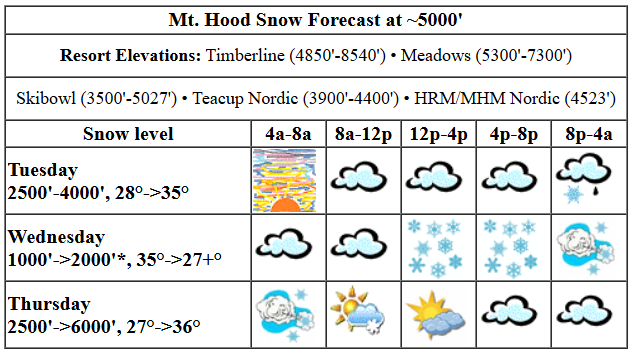
Let’s look at Tuesday’s weather: a spectacular mountain sunrise is followed by increasing clouds. Precip arrives mid to late afternoon, probably in mixed form. The snow level today will be around 2500′ early. It slowly rises to 4000’… but wait… temps at 850mb (~5000′) will be bouncing around above and below freezing. After 4pm, we’ll pick up about 0.2” water equivalent (WE), probably as mixed precip, and probably with some minor icing of lifts. Wind: Light this morning rising to SW 10-15 this afternoon and SSW 15-30 after midnight.
Wednesday morning kicks off with lingering mixed precip, but it’ll be so light we can just call it a race. Precip increases in the afternoon as a low pressure system approaches. There’s still a fair bit of uncertainty on the deets for Wednesday night. Models have anywhere from 0.8” to 2.0” WE depending on where the low goes and how much wind accompanies it; the deterministic GFS ramps the wind up to shutdown territory (WNW 55) and gives us 2.0” WE for massive snowfall. Other ensemble members are less aggro. For now, let’s say that temps drop from the mid 30s in the morning to 30F in the afternoon and 27F overnight, turning the mixed precip to snow (hopefully) and leaving us with a foot or more of new. Wind: Like I said, it’s pretty uncertain – most ensemble members don’t take us to shutdown territory, but you can expect the wind to pick up, maybe way up, after 1pm.
ON to Thursday… lingering light snowfall in the morning gives way to sun in the afternoon and clouds with warming temps overnight. The snow level will be 2000′ in the morning, 4500′ in the afternoon, and 6000′ overnight with temps at 5000′ around 27F in the morning, 33F in the afternoon, and 37F overnight. About 0.3” WE is forecast early in the morning for 3” new snow. After 7am-ish: dry. Wind: WNW (strong?) early dropping in the afternoon and becoming light overnight. If the strongest scenario plays out, there could be lift disruptions in the morning.
Dry, cloudy, above-freezing weather is in the cards for Friday. The freezing level will be around 6000′, and temps will be in the mid 30s. Wind: light SW to start rising to SW 15-30. Saturday morning currently looks dry, but Pineapples may arrive in the afternoon. Pretty much all the ensembles members have some sort of warm/wet experience planned for you on Sunday, potentially a very wet experience known as the Pineapple Express. Hefty bags will definitely be in order. That’s all. Enjoy the fantastic conditions today!
Liking this forecast?
GORGE WIND FORECAST

Hi friends! Active weather is in the cards this week, and that means we’ll have some wind and lots of rain. Not much happens Tuesday: we starts with light easterlies, less than 10mph. The wind picks up to E 15mph at Stevenson this afternoon, 10mph at Iwash, and 10-15mph east of Viento all the way out past The Dalles. River flow over the last 24 hours was 81-137kcfs, river temp is 38.12F, and high temp forecast is for mid 40s.
Wednesday starts with strong easterlies as a compact low sets up offshore. Maybe. There’s still some question in whether this will happen. Anyway, easterlies will potentially be 50mph at Iwash early with 35mph at Stevenson. By late morning, the wind drops to 10-15mph at both spots. West wind arrives late, probably after dark. High temp: 44F with cloudy weather in the morning and pouring rain in the afternoon. Thursday sees lingering westerlies after that low moves inland. Models are all over the place on how strong they will be. For now, call it 16-19 from Stevenson to Swell and from Avery to Arlington in the morning with less wind from Hood River to Doug’s. Afternoon: 18-22 out east (maybe) and less than 10mph west of The Dalles. High temp: 49F with rain early and dry weather later. The wind forecast is uninspiring through the weekend as a Pineapple Express takes aim at us Saturday afternoon into Sunday. Have a great day today, everyone!
BARE BONES HOOD RIVER WEATHER FORECAST
Fog this morning and cloudy later. Temps start in the upper 30s and rise to the mid 40s. Nearly calm wind. No rainbows. Rain overnight with snain possible late. Wednesday will be snainy in the morning, dry midday, and wet from early afternoon on into the night. Temps start in the mid 30s and rise to the mid 40s. Easterlies during the day. Westerlies overnight. No rainbows. Thursday will be rainy early then dry. Temps start in the upper 30s and rise to the upper 40s. Moderate westerlies. 99% chance of rainbows.
TEMIRA’S AWESOME TRAVEL ADVISORY SERVICE
HYPERLOCAL FORECAST FOR THE COLUMBIA GORGE
THE DALLES, HOOD RIVER, WHITE SALMON, TROUT LAKE, STEVENSON, CASCADE LOCKS, PARKDALE, ODELL, HUSUM, BZ, MILL A, WILLARD, GOLDENDALE, RUFUS, ARLINGTON, boardman
Good morning, neighbors! We have a few extra-special sub-freezing areas this morning, but most of us are hovering a degree or a few above that 32F break point. Those of us above the fog (fog, fun!) saw a spectacular sunrise today, while those of us below it may just have caught the glow through the Nothing. We sure do have some interesting weather coming this week – lots of precip Wednesday night, and lots more starting sometime Saturday and continuing on and off through Tuesday. Just how much precip? Almost certainly enough to get Hood River back above water year average – that little hamlet is currently sitting at -1.45” for the year.
Let’s check in with Glenwood. I thought I would have to berate them for being above freezing, but in the last hour, they dropped to 31F. Bet the roads are icy there (and near Parkdale, some areas of The Dalles, High Prairie, Centerville, Goldendale, and other areas exposed to partly cloudy sky last night). Next up: the TATAS Executive Order Of The Day: I just overturned Citizens United and Buckley v. Valeo and Speechnow.org v. FEC with a swipe of my pen. Unlimited political spending by individuals and corporations is no longer legal. Candidates must now rely on grassroots funding rather than Super PACs and high-dollar donors. You’re welcome.
Speaking of the state of the nation… I’ve been reading the oddest comments online. People are saying that the reason protests and demonstrations are happening, the reason that the voices are so loud and upset, is that Musk and Trump are doing the right thing. Huh? So, if someone is being beaten or assaulted and they’re protesting, their screams are a sign that the attacker is doing something correct? That seems like a dangerous thing to believe.
tuesday
Weather today: clouds increase. Intermittent drizzle is possible as far east as Viento or so until midday. Next up: rain moves in from the west this afternoon and eventually extends, after midnight, all the way to Threemile, South Wasco, and Sherman counties from midnight on. Rain will be heavy overnight in many areas. With temps aloft likely to be a few degrees above freezing, that puts any sub-freezing areas in the Gorge at risk for freezing rain. It seems pretty icing will happen given we have daytime heating Tuesday followed by clouds to keep that heat in. It does seem likely that icing will happen in my house today – I’m making cinnamon rolls for the nice folks at the Hood River Post Office. All I have to do is keep from eating them all myself… Tuesday temps: upper 30s along the river early and mid 40s later.
wednesday
Most folks get a short break from the rain Wednesday morning. Don’t get all cozy with that dry weather: an offshore system taps into tropical moisture and turns the western Gorge into a waterfall Wednesday afternoon all the way through the Thursday morning commute. Heaviest rain will be west of The Dalles and east of Rufus (and also in the WA hills and plateaus) with a dry slot between The Dalles and Amayah’s. Temps will be in the mid/upper 30s early and mid 40s later with nuking east wind at Iwash (cock) Rock and Stevenson early and easterlies at 10-15mph all through the Gorge in the afternoon. Overnight, the wind turns westerly, and could potentially be quite strong at all elevations.
thursday and beyond
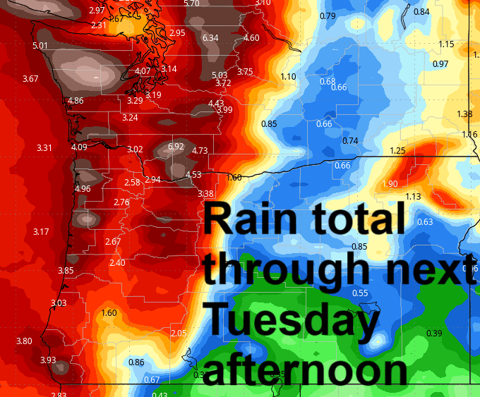
After lingering heavy rain for your Thursday morning commute, you’ll have dry, moist weather for the rest of the day. With west wind in the cards, we should have sunbreaks east of Viento. Temps rise to nearly 50 degrees, and westerlies pick up to 10-20mph. Friday looks dry. Saturday morning looks dry. By Saturday afternoon, the Pineapple Express takes aim at the Gorge. Rainfall totals look quite impressive west of Hood River; lesser rain is forecast to the east, but we’ll all end up with a good soaking before this finishes up. Take a look at the Euro 50th percentile precip total map through Tuesday 4pm. Impressive. That’s a low-res map. It’ll be interesting to see the numbers when the high-res version comes out. More rain is forecast on and off through Tuesday. After that, it looks like we’ll see some warm, dry weather for a few days. False spring! Yay! Safe travels. -TATAS
HEY! DON’T STOP READING! Is this community-focused forecast helpful to you? It sure is! It takes me a couple hours a day to write. Please join your friends and neighbors in contributing to keep it going. Venmo: @thegorgeismygym PayPal: twomirrors@gmail.com USPS: Temira / PO Box 841 / Hood River, Oregon 97031 You can test out the forecast subscription for a few days for free by clicking this link: https://subscribepage.io/YhevGc
