

MT HOOD SNOW FORECAST

Hey skiers and snowboarders! “Chaotic” remains the word for the week on Mt Hood. In a fun twist, NWS also landed on that description for this week’s weather in today’s AFD. Here’s the snapshot of the weather through Sunday: light rain/mixed precip today, heavy rain tonight, light snow Wednesday into Thursday, snow followed by torrential rain followed by snow on Thursday with powerful wind and blizzard conditions at times. Light snow lingers into Friday followed by a dry day Saturday and light rain on Sunday. Forecast details continue to shift, but the general picture remains the same as yesterday.
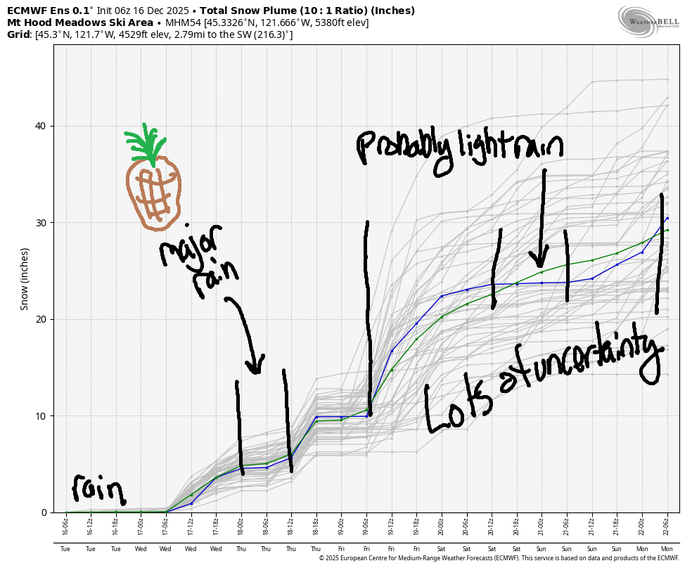
Short term Mt Hood snow forecast
Tuesday starts off with rain/mixed precip in the 5000′-6000′ zone. Dry weather arrives late morning and sticks around until early afternoon. Overnight, the snow level rises to 9000′ with the arrival of a warm atmospheric river and crashes to 1500-2000′ after midnight with the passage of the cold front. We’ll see about 1.3” rain prior to the cool air arriving. In that transition period, 0.6” water equivalent (WE) is forecast. Call it 2-5” new depending on elevation. Wind: WSW 25-25 this morning, SW 40-60 this evening, and WNW 55 (massive orographic effects, significant icing on lifts) after midnight as the cold front moves through.
Snow continues on Wednesday with the snow level around 2000′. As of right now, we’re looking at 0.3” to 0.4” WE for 3-5” relatively light new snow. Wind: WNW 55 early, W 30 in the afternoon, and SSW 10-20 after midnight. We could see enhanced snowfall and higher totals early thanks to the very strong WNW wind.
Extended Mt Hood Snow Forecast
Super-moist tropical air approaches on Thursday along with rather strong wind aloft. The day starts with the snow level around 1500-2000′, but it quickly rises to 9000′ by mid-morning. Temps lower in the evening. This brings the snow level down to 4000′ by 10mp and 2000′ after midnight. Precip types: all over the place! 0.3” WE as snow early – that’ll be about 2-3” of very dense snow thanks to warming aloft. During the day, we’re expecting upwards of 3” rain (sad). In the evening, rain transitions to snow. In that transition period, we’re expecting 0.7” WE for 3-5” dense, wet snow. That’s followed by 0.8” WE as snow, for 6-10”. Wide range there is due to orographic effects and possible terrain enhancement of totals. Wind: SSW 10-20 early, WSW 40-60 midday, W 45 overnight.
Light, intermittent, orographic snowfall continues into Friday with the snow level around 2000′. we’re only expecting an inch or two. Saturday looks sunny for at least part of the day with dry weather. On Sunday, another warm/damp system is forecast to arrive from the southwest. This one’s likely to bring light drizzle to Mt. Hood. Beyond that, model uncertainty increases, so I’m setting down my pen and finishing up for today. Given the rain that’s forecast on Thursday, we’re counting on the end of that system to get us going. I think it’ll be just enough to get some lifts turning; the intraquartile range (25th through 75th percentile) through Saturday is 20-30” of snow for Mt Hood. Fingers crossed!
Was that helpful? I knew it was! Guess what? All of this crucial work – from your personal wind and snow reports to the invaluable TATAS updates – is made possible by my relentless efforts. Maintaining this labor of love isn’t easy. Each daily forecast takes hours. Website hosting, weather model access, and back-end admin work takes time and money. That’s where you come in.
YOUR CONTRIBUTION MAKES A DIFFERENCE
- SUPPORT ACCURATE, HYPER-LOCAL WEATHER FORECASTING
- ENABLE ACCESS FOR ALL, EVEN THOSE WITH LESS MEANS
- SUPPORT A COOL HUMAN WHO WORKS HARD SO YOU CAN PLAY
Take a moment to click one of the buttons below. Donate $19.99 or more (how much does this forecast enhance your life?) and get the email in your inbox. Whether it’s a renewing subscription (auto-renew) or a one-time donation, every contribution makes a real difference. Help me keep this labor of love alive, so we can all continue playing, commuting, and living in the Gorge with peace of mind and the best weather forecasts possible. Thank you!


Hood River, Oregon 97031


GORGE WIND FORECAST
If you’re still seeing yesterday’s and it’s after 9am, try opening this in an incognito window
today’s gorge wind forecast
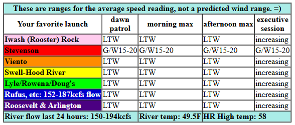
Hi friends! Exciting stuff in today’s Gorge wind forecast. Beyond tomorrow, there’s not much happening, so hopefully you’re able to make something happen on Wednesday. Tuesday started off with light onshore gradients: 30.08/30.06/30.05 with Stevenson reading 15-20mph and other locations light/variable. Models hold the wind at 15mph(ish) near Stevenson and perhaps Viento today with not much elsewhere until after dark. River flow over the last 24 hours was 150-194kcfs, river temp is 49.5F, and high temp forecast is 58F.
RIVER FLOW FOR SITES BETWEEN AVERY (EAST OF THE DALLES) AND RUFUS: CLICK HERE FOR JOHN DAY DAM FLOW.
RIVER FLOW FOR SITES BETWEEN STEVENSON AND DOUG’S BEACH (WEST OF THE DALLES): CLICK HERE FOR THE DALLES DAM FLOW

tomorrow’s gorge wind forecast
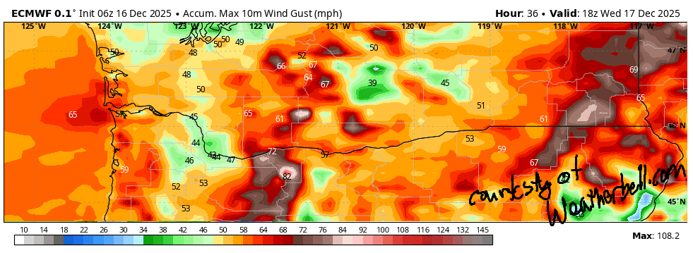
Overnight Tuesday into Wednesday, a powerful system swings through. Accompanying this: 30-40mph west wind with much stronger gusts. Gusts will exceed 50mph overnight. Now, you’re probably wondering how much wind will be left for you after daybreak. Great question! Models suggest a brief nuker dawn patrol all the way from Multnomah Falls out to Hermiston. After 7am, the wind backs off west of The Dalles, leaving the Hatch with perhaps 20mph.
From Avery eastward, 30+mph wind continues until early afternoon, when the speed plummets. High temp: 47F in Hood River and 53F in the desert under partly to mostly cloudy sky. Do watch for debris in the water, and remember that current approaching 200kcfs at Rufus will have a significant impact on your experience.
extended Gorge wind forecast
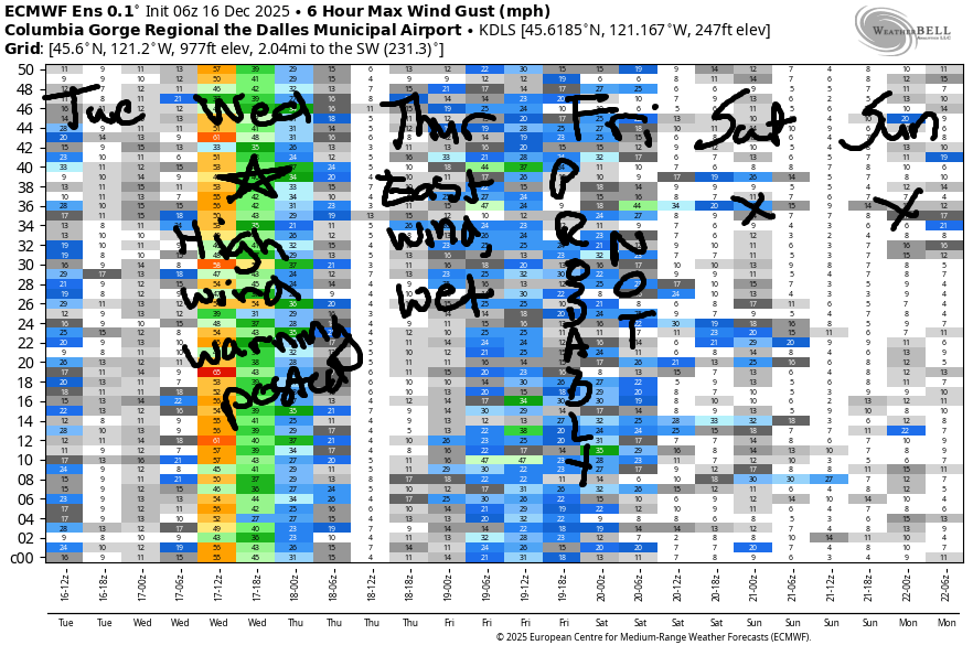
Thursday brings a strong (992mb) low offshore and torrential rain. Expect east wind at 30-35mph at Iwash and 25mph at Stevenson in the morning with lighter wind in the afternoon. High temp: 48F. Friday look light west of The Dalles with upper teens east of The Dalles. Saturday: light easterlies. Sunday: probably not much either. That’s it for now. Given that ski season is nigh upon us, it’s time for me to switch the forecast to the afternoon, assuming I can manage to switch my life around like that. Hope to see you on the Nch’i Wana tomorrow!
BARE BONES HOOD RIVER WEATHER FORECAST
Rain this morning, dry most of the day, pouring rain overnight. Temps start in the upper 40s and rise to the upper 50s. Light westerlies in the morning, moderate late afternoon, nuking overnight. Slight chance of thunder overnight. Wednesday will be rainy early and showery into the afternoon. Temps start in the low 40s and rise to the upper 40s. Nuking west wind early. Moderate later. 99% chance of rainbows. 87% chance of doubles. Thursday will be soakingly torrentially wet. Temps start in the mid 30s and rise to the upper 40s. Light to moderate easterlies. 2% chance of rainbows.
TEMIRA’S AWESOME TRAVEL ADVISORY SERVICE
HYPERLOCAL WEATHER FORECAST FOR THE COLUMBIA GORGE
THE DALLES, HOOD RIVER, WHITE SALMON, TROUT LAKE, STEVENSON, CASCADE LOCKS, PARKDALE, ODELL, HUSUM, BZ, MILL A, WILLARD, GOLDENDALE, RUFUS, ARLINGTON, boardman

Good morning, neighbors! All sorts of exciting stuff happening in today’s forecast. First off, no reports of ¡CE-y conditions in the Gorge so far today. Just lots of big puddles on the road between us and the metro area. I have a couple of upcoming safety warnings regarding the weather.
WARNINGS: First, very strong wind Tuesday night into Wednesday morning is going to bring down some trees thanks to super-saturated soil. If you can avoid 84/14 in that time period, please do. In addition to the wind, there will be very heavy rain as far east as The Dalles (and WA hills). Yuck. Avoid. Next up: the snow level falls as low as 2000′ Wednesday daytime – a trace to 2” of snow is possible in Snowden, Underwood, and the Mill A area. NEXT: torrential rain Thursday between 1am and 1pm. When I say “torrential”, I mean it. We’re in daily-record territory with this system – the Euro has very heavy all the way out into the desert. But wait, there’s more: there’s a slight possibility of some very wet snow or select icy areas down to 1000-1500′ early Thursday before everything warms up. Probably not, but can’t rule it out yet. ON Friday, the snow level falls to 2000′ with a trace for some of you. Saturday – colder with widespread icy roads possible.
Glenwood this morning
Geez, that was pretty much the entire forecast right there. But we’d still better check in with Glenwood: it was 47 degrees there this morning and everyone was shaking their heads in disappointment as Glenwood just isn’t cold like it’s supposed to be. Everyone’s considering moving to Michigan where temps are a friends -10F today.
Today’s Gorge weather forecast
Here in the Gorge, we start in the upper 40s and finish in the upper 50s. Today’s record high is 62F, so we probably won’t break it. We did set a record high yesterday, though! Moderate rain stretches as far east as The Dalles this morning. We’ll have a dry period midday. Rain returns this evening. Wind will be out of the west at 15-20mph west of Viento today with light wind elsewhere.
Wednesday’s Gorge weather forecast
Overnight tonight (it’s Tuesday), a powerful system arrives. Expect west wind at 30-50mph (stronger gusts, see image) from this evening into Wednesday morning. As I mentioned before, this is likely to take down trees – the wind will be on the river, in the hills, and sneaking in to all the cracks and crevices in your home. Accompanying this: pouring round from 10pm on as far east as The Dalles with moderate rain out in the desert. South Wasco: even you get rain after midnight.
Rain tapers off east of Mosier around 10am, but light rain continues on and off as far east as Hood River all day. Expect rainbows and doubles all day long. Temps start near 40 and rise to 47F (west) and 53F (desert) with 50F near The Dalles. Wind stays strong (20+ near Hood River, 30+ from The Dalles eastward) until early afternoon, when it finally starts to fade.
Thursday’s Gorge weather forecast
A truly impressive atmospheric river strikes on Thursday. Very, very, very heavy rain is forecast all day west of The Dalles with plain old “heavy rain” east of The Dalles and moderate rain in South Wasco. In an interesting twist, the timing is conducive to isolated pockets of wet, heavy snow or even ice, although the probability is low. Thursday’s wind will be E 20-30mph near Iwash (cock) Rock and Stevenson. That fades in the afternoon. Given the already-saturated soils combined with the intensity of the rain (multiple inches), debris flows and landslides and quick river/stream rises are likely. Seriously, you do NOT want to drive the western Gorge on Thursday.
Extended Gorge weather forecast
Rain eventually tapers off on Thursday night, and the snow level falls to 2000′ by Friday morning. There won’t be much moisture left, but we could see cold enough temps for icy roads in some areas depending on the cloud coverage. Cooler weather on Saturday combined with areas of clear sky sets us up for some icy roads. Drizzle returns on Sunday. Gosh golly. That’s a lot. Safe travels. -TATAS
HEY! DON’T STOP READING! Is this community-focused forecast helpful to you? It sure is! It takes me a couple hours a day to write. Please join your friends and neighbors in contributing to keep it going. Venmo: @thegorgeismygym PayPal: twomirrors@gmail.com USPS: Temira / PO Box 841 / Hood River, Oregon 97031 You can test out the forecast subscription for a few days for free by signing up below. Easy! Do it!
JONES BEACH, SAUVIE ISLAND, & COAST FORECAST
ON WINTER VACATION UNLESS DESPERATELY NEEDED.
