

MT HOOD SNOW FORECAST

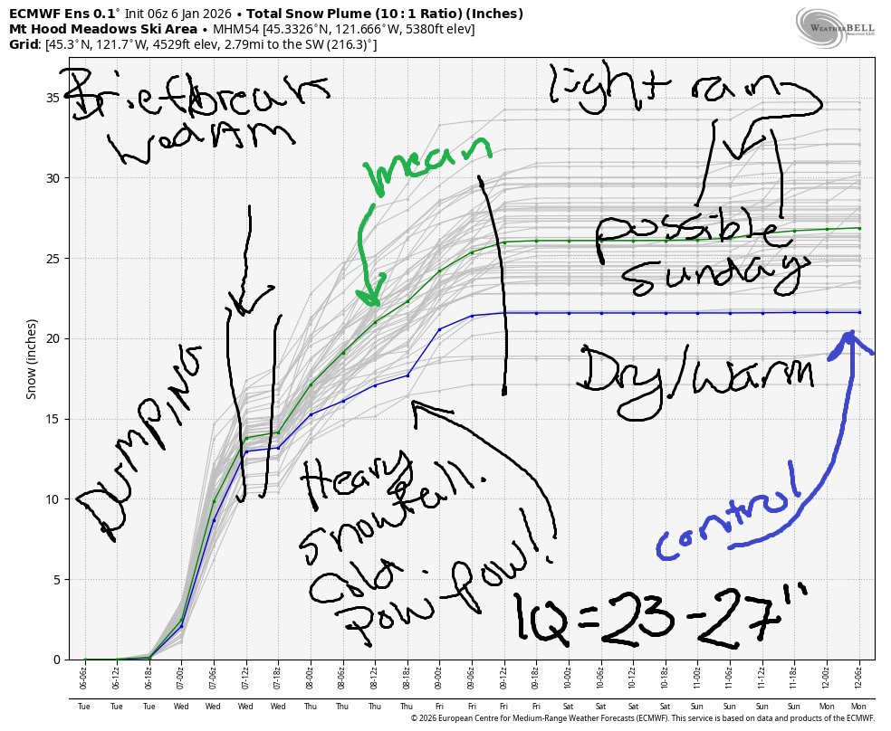
Hey skiers and snowboarders! Finally, finally, finally, we have a big dump in the forecast for Mt Hood! Along with cold temps, we’re expecting at least a couple feet of snow over the next couple of days. Those of you who like storm skiing are going to have a dang fine time on the slopes, and those of you who want your snow with sunshine will be happy this upcoming weekend.
Looking at the more distant future, we have warm, often-sunny weather starting Saturday and continuing (probably) all the way through next week. Uncertainty skyrockets around Thursday the 15th, so that’s the end of our reliable forecast period. Let’s jump into this (very happy) forecast, shall we? Wait, before we do, the intraquartile range (25th percentile to 75th percentile) through Friday: 23-27” new snow, but that’s with a 10:1 ratio, and we’ll beat that. More snow is expected!
Short term Mt Hood snow forecast
On Tuesday morning, Mt Hood was overcast and waiting. Snow arrives by 10am, and the intensity increases overnight. The snow level starts around 2000′, drops to 1000-1500′ briefly mid-morning (thanks to evaporative cooling), rises to 4000′ in the afternoon, and crashes to around 1000′ overnight. Here’s the fun part: during the day, we’re expecting about 0.4” water equivalent (WE) for 4-5” medium-density snow. From 4pm on through Wednesday morning, we’re anticipating about 1.4” WE for 14-17” additional snowfall. Wind will be SW 15-30 this morning, SW 35-60 this afternoon and evening, and WSW 25-30 after midnight. While that wind sounds strong, it’s not a direction that usually impacts basic lift ops, so I’d say you’re good to go.
Heavy snow, powder-style, continues all day Wednesday. The snow level will be 1000-1500′ early and will fall to 500-1000′ in the afternoon before dropping below 500′ near Mt Hood overnight. During the day, 0.8” WE is forecast. That’s 8-10” powder. Afternoon and evening: 0.3” WE for 3-4” powder. We could get a little more overnight thanks to the wind speed and direction: Morning wind will be WSW 25-30. Afternoon: W 30. Overnight: WNW 30-40mph, enough to wring out all possible snow thanks to orographic assistance. If that WNW wind is a little stronger or comes in a little earlier, it’s possible it could have some impact on night ski ops, but that’s a marginal strength/direction for chaos.
Extended Mt Hood Snow Forecast
A few lingering orographic flurries are possible Thursday for an inch during the day and an inch overnight, max. The snow level will be 0-1000′ in the morning, 1000′ in the afternoon, and 1500-2000′ overnight. Wind: WNW 30-40mph in the morning, WNW 25-30mph in the afternoon, and W 15 overnight. That’s the end of the snowfall for a while.
Friday look partly cloudy. The free air freezing level (FAF) rises from 1500′ early to 5500′ in the afternoon and 8000′ overnight as much warmer air moves inland. Temps max out near 40F at 5000′ after starting the day in the mid 20s. Wow, that is some swing in temps! Wind will be W 15 in the morning, light/variable in the afternoon, and S 15 overnight. We’re looking at a warm/sunny Saturday with light wind. It’s possible we could see clouds and a little drizzle on Sunday. Please cross your fingers this doesn’t happen, as that would not be helpful for snow quality. Beyond Sunday, we’re looking at several days (at least) of warm, dry weather. Model agreement falls apart at the end of next week, so that’s all I’ve got for you today. Enjoy all this incoming snow!
Was that helpful? I knew it was! Guess what? All of this crucial work – from your personal wind and snow reports to the invaluable TATAS updates – is made possible by my relentless efforts. Maintaining this labor of love isn’t easy. Each daily forecast takes hours. Website hosting, weather model access, and back-end admin work takes time and money. That’s where you come in.
YOUR CONTRIBUTION MAKES A DIFFERENCE
- SUPPORT ACCURATE, HYPER-LOCAL WEATHER FORECASTING
- ENABLE ACCESS FOR ALL, EVEN THOSE WITH LESS MEANS
- SUPPORT A COOL HUMAN WHO WORKS HARD SO YOU CAN PLAY
Take a moment to click one of the buttons below. Donate $19.99 or more (how much does this forecast enhance your life?) and get the email in your inbox. Whether it’s a renewing subscription (auto-renew) or a one-time donation, every contribution makes a real difference. Help me keep this labor of love alive, so we can all continue playing, commuting, and living in the Gorge with peace of mind and the best weather forecasts possible. Thank you!


Hood River, Oregon 97031


GORGE WIND FORECAST
If you’re still seeing yesterday’s and it’s after 9am, try opening this in an incognito window
SHORT-TERM gorge wind forecast
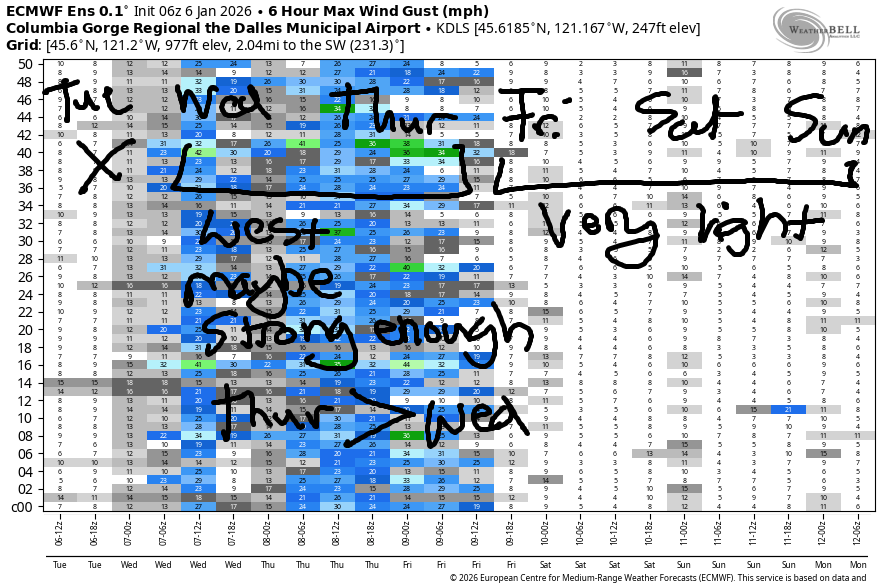
Hi friends! Onshore flow continues through Thursday giving us marginal opportunities for windsport westerlies. Between Friday and Sunday, ridging takes over and shuts the wind down. Starting next Monday, we’re likely to see a period of strong and relatively warm (40+ degrees) easterlies.
Tuesday started with pressures of 30.03/29.98/29.94. Wind was light/variable most places with westerlies at 10-13mph between Stevenson and Viento. Models slowly build the wind into the evening, but they keep it west of the Hatch and east of John Day Dam. We’ll eventually see gusty 20-24mph from Stevenson to Viento and the same near Arlington. In between those locations, there won’t be much wind at all. There is a slight chance the wind could make it to the Hatch, but models aren’t optimistic. River flow over the last 24 hours was 180-200kcfs, river temp is 43.2F, and high temp forecast is 45F with rain after 10am.
RIVER FLOW FOR SITES BETWEEN AVERY (EAST OF THE DALLES) AND RUFUS: CLICK HERE FOR JOHN DAY DAM FLOW.
RIVER FLOW FOR SITES BETWEEN STEVENSON AND DOUG’S BEACH (WEST OF THE DALLES): CLICK HERE FOR THE DALLES DAM FLOW

LONGER-TERM gorge wind forecast
Wednesday starts with light westerlies, perhaps 10-13mph, between Stevenson and Viento and also near Arlington. Everywhere else: even lighter. Afternoon wind rises to 14-17mph from Stevenson to The Dalles with 18-22mph from Avery to Threemile. High temp: 43F. Thursday starts with 10-13mph from Stevenson to Viento and also from Avery to Hermiston. Once again, the area in between those two zones will be light. Thursday’s our best chance for stronger wind; as of right now, models give us 20-23mph from Philippi Canyon to the Tri-Cities for a few hours between 10am and 1pm. Areas west of John Day Dam stay under 15mph all day. After 1pm, the wind drops below 15mph everywhere. High temp: 44F with clouds to the west and partly cloudy sky out east.
Between Friday and Sunday, not much wind is forecast – perhaps light to moderate easterlies. As a cold(ish) pool develops in the desert, easterlies start to pick up. By Monday, models are calling for strong (40+ at Iwash) east wind for a few days. Given the overall setup, sunshine is likely, as are above-freezing temps. The combo of air temp + water temp won’t exactly be warm, but it won’t be the coldest ever either. Stay safe out there!
BARE BONES HOOD RIVER WEATHER FORECAST
Cloudy today with drizzle (mixed with wet snowflakes) through midnight. Temps start in the low 30s and rise to the mid 40s. Light to moderate westerlies. 98% chance of rainbows. Wednesday will be rainy. Temps start in the mid 30s and rise to the low 40s. Light westerlies. 84% chance of rainbows. Thursday will be showery and mostly cloudy. Temps start in the mid 30s and rise to the mid 40s. Light westerlies. 18% chance of rainbows.
TEMIRA’S AWESOME TRAVEL ADVISORY SERVICE
HYPERLOCAL WEATHER FORECAST FOR THE COLUMBIA GORGE
THE DALLES, HOOD RIVER, WHITE SALMON, TROUT LAKE, STEVENSON, CASCADE LOCKS, PARKDALE, ODELL, HUSUM, BZ, MILL A, WILLARD, GOLDENDALE, RUFUS, ARLINGTON, boardman
Good morning, neighbors! Tricky forecasting today as significant precipitation encounters near-freezing temps with assistance from evaporative cooling. Wednesday’s weather is easier to call – cooler temps aloft will drag the snow level down below 1500′ through Thursday. Starting Friday, high pressure takes over the Pacific Northwest, and warmer air aloft sets us up with an inversion – much warmer air aloft and much cooler air at the surface. More deets to come…
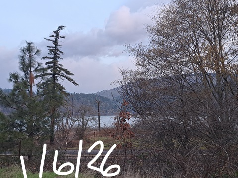
Glenwood this morning
Meanwhile… In Glenwood this morning it was 37 degrees thanks to exposure to west wind. Everyone in Glenwood was exposing themselves to westerlies, confusing exposure to westerlies with Expose Yourself To Art. Art, not wanting to see this, left Glenwood to have breakfast in The Dalles. Areas not exposed to the morning westerlies were generally in the 31-35 degree range except near Stevenson, where low 40s were the rule. That rule is taken very seriously in Stevenson – everyone who’s not in their early 40s has been forced to leave.
Today’s Gorge weather forecast
Elsewhere in the Gorge, we’ll definitely have some black ice thanks to partly cloudy sky last night. Not seen yet: ¡CE-y roads, thankfully.
As precipitation arrives mid-morning, evaporative cooling may drag the snow level down as low as 1000-1500′. Here’s the tricky thing: westerlies aloft will be too warm for snow. Meh. Tricky. Let’s say mixed wintry precip is possible down to 1000′ or so this morning before a switch to pure rain for all.
Rain extends as far east as Hood River by 10am, Rowena by 1pm, Biggs by 4pm, and Arlington by 7pm. South Wasco sees a bit of rain/wet snow from 10pm to 1am. Lowland temps max out in the mid 40s. Today’s wind will be 20-25mph west of Underwood and near Arlington with light wind along the river in between. Up in the hills, expect moderate SW wind. Ditto for South Wasco and Sherman and Gilliam Counties, where the SW wind rises to 30mph this afternoon and into the night.
Wednesday’s Gorge weather forecast
Overnight, the snow level falls from 4000′ to 1000′-1500′ as temps aloft drop from -1C to -4C. Most of the precip will be done by then, but Trout Lake, Underwood, Willard, Mill A, Snowden, and Parkdale could pick up an inch or so of snow by sunrise. The weather gets more interesting on Wednesday as the snow level falls from 1000-1500′ early to 1000′ in the afternoon. Add in moderate to heavy precipitation and evaporative cooling for a few inches of snow in Trout Lake, Willard, Parkdale, Underwood, Snowden, Appleton, and possibly High Prairie. Down in the lowlands, temps rise from the mid 30s to the low to mid 40s thanks to west wind at 10-20mph.
Thursday’s Gorge weather forecast
Thursday brings intermittent snow flurries above 500′ with snain (sloppy rain) down low. Morning temps along the Nch’i Wana will be in the low-mid 30s. Afternoon: mid 40s. West wind 10-20mph. Rainbows: yes.
Extended Gorge weather forecast
Friday and Saturday look dry and at least partly sunny with temps rising to the mid to upper 40s. Maybe. I’m not sure I trust that temp forecast given the developing inversion and light wind. Either way… it’s possible we could see a little drizzle on Sunday, but it’s also possible we’ll stay dry. Starting Monday, we tumble into a massive inversion with dry weather for at least a few days. Models currently hold off on the Nothing cloud and offer sunshine instead. That would be AMAZING. Okay, that’s enough typing for now. Safe travels. -TATAS
HEY! DON’T STOP READING! Is this community-focused forecast helpful to you? It sure is! It takes me a couple hours a day to write. Please join your friends and neighbors in contributing to keep it going. Venmo: @thegorgeismygym PayPal: twomirrors@gmail.com USPS: Temira / PO Box 841 / Hood River, Oregon 97031 You can test out the forecast subscription for a few days for free by signing up below. Easy! Do it!
JONES BEACH, SAUVIE ISLAND, & COAST FORECAST
ON WINTER VACATION UNLESS DESPERATELY NEEDED.
