

MT HOOD SNOW FORECAST

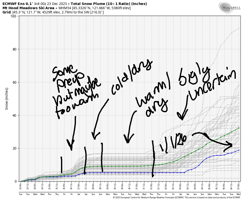
Hey skiers and snowboarders! We’ve finally got a few lifts turning at Meadows and Timberline. Yay! Skibowl: not yet. Teacup: too muddy and wet, and not snowy enough to groom. Looking at the next week or so, the picture isn’t pretty. After some light mixed precip late Tuesday and also on Thursday, we enter a period of warm and dry weather Sunday into next week.
Precip is unlikely to return prior to the start of 2026. It’s unclear what form that precip will take when it does return; while models do agree on precip, there’s quite a range of possible temps along with the return of moisture. I’m not making any guesses yet about p-type!
Short term Mt Hood snow forecast
Looking at Tuesday, we have light flurries to start. Midday looks partly cloudy. Light mixed precip arrives mid-evening and switches to light rain overnight. The snow level will be around 2000′ early, 6000′ in the evening, and 7000′ after midnight. Just 0.1” to 0.2” water equivalent (WE) is forecast tonight for zero accumulation. Wind will be SW 10-15 this morning and will build to a stronger south wind overnight. By midnight, wind speed will be S 25-40. It holds into Wednesday morning.
A little mist/drizzle early Wednesday quickly gives way to partly cloudy then clear sky. Clouds return after midnight. The snow level will be 7000′ early and 10,000′ around sunrise. It falls to 4000′ in the afternoon and holds overnight. Wind: S 25-40 in the morning, SW 40-65 in the afternoon, and ESE 25-30 after midnight. It’s worth noting that there’s high uncertainty in the overall weather pattern Wednesday, and the details of this could change. Given the warmth associated with the incoming system, the precip type is unlikely to change. We could see slightly more or less rain, and we could see somewhat more or less wind.
Extended Mt Hood Snow Forecast
Thursday brings another marginally-cold system with another round of light precip. The snow level will be 4500′ in the morning, 6000′ in the afternoon, and 4000′ after midnight. About 0.3” WE is forecast during the day as mixed precip. That’s 1-3” snow way up high and zero to a trace of accumulation at 5000′. In the afternoon and evening, instability may drive additional precipitation, but the snow level will be around 6000′ at that time. Wind: ESE 25-30 early, S 20-40 mid-morning, S 15-30 in the afternoon, and SSW 5-10 overnight. Friday: probably sunny with light wind and a freezing level of 4000′
A brief period of colder, sunny weather is forecast on Saturday along with light wind. Warmer, (probably) sunny, definitely dry weather is in the cards starting Sunday and continuing for an uncertain duration in to next week. As I mentioned at the beginning of the forecast, precipitation isn’t expected to return until the start of 2026 unless something changes in the models. At this point, it’s unclear what p-type we’ll be seeing, so I’ll hold off on guessing. Get up there and get some turns while you can! Hope to see you on the snow soon!
Was that helpful? I knew it was! Guess what? All of this crucial work – from your personal wind and snow reports to the invaluable TATAS updates – is made possible by my relentless efforts. Maintaining this labor of love isn’t easy. Each daily forecast takes hours. Website hosting, weather model access, and back-end admin work takes time and money. That’s where you come in.
YOUR CONTRIBUTION MAKES A DIFFERENCE
- SUPPORT ACCURATE, HYPER-LOCAL WEATHER FORECASTING
- ENABLE ACCESS FOR ALL, EVEN THOSE WITH LESS MEANS
- SUPPORT A COOL HUMAN WHO WORKS HARD SO YOU CAN PLAY
Take a moment to click one of the buttons below. Donate $19.99 or more (how much does this forecast enhance your life?) and get the email in your inbox. Whether it’s a renewing subscription (auto-renew) or a one-time donation, every contribution makes a real difference. Help me keep this labor of love alive, so we can all continue playing, commuting, and living in the Gorge with peace of mind and the best weather forecasts possible. Thank you!


Hood River, Oregon 97031


GORGE WIND FORECAST
If you’re still seeing yesterday’s and it’s after 9am, try opening this in an incognito window

SHORT-TERM gorge wind forecast
Hi friends! Mild winter weather continues… We’ll have building easterlies on Tuesday, probably, as a system nears the coast. Models contain vast uncertainty about the evolution of this system on Wednesday, leaving us with a low confidence forecast. Easterlies return Thursday in response to another offshore low. High pressure builds on Friday and might happen early enough for just enough west wind to get some of us on the water. As that high pressure settles in over the weekend, we’ll enter a more typical wintertime east wind pattern.
Looking at Tuesday, we have calm wind to start. Easterlies build during the day. By mid-afternoon, we should have 20-25mph at both Stevenson and Iwash (Rooster) Rock. Overnight, the wind (probably) continues to build. River flow over the last 24 hours was 167-207kcfs, river temp is 48F, and high temp forecast is 44F and cloudy.
RIVER FLOW FOR SITES BETWEEN AVERY (EAST OF THE DALLES) AND RUFUS: CLICK HERE FOR JOHN DAY DAM FLOW.
RIVER FLOW FOR SITES BETWEEN STEVENSON AND DOUG’S BEACH (WEST OF THE DALLES): CLICK HERE FOR THE DALLES DAM FLOW

LONGER-TERM gorge wind forecast
Strong easterlies start the day on Wednesday in response to an offshore low. Uncertainty enters the picture midday as the track of the low could result in decreasing easterlies or even a switch to westerlies. High temp: 48F with drizzle early and sunshine later. Thursday starts with moderately strong east wind: 25-30mph at Stevenson and 40mph at Iwash (Rooster) Rock. The wind holds through midday and fades to 20mph in the afternoon. High temp: 44F with partly cloudy sky.
Ridging enters the picture on Friday. If it happens just right, we’ll see westerlies at 17-20mph or so from Stevenson to Doug’s. About 15% of the ensembles call for lighter wind, and about 10% call for stronger wind. Fingers crossed! High temp: 47F. Saturday looks calm. Beyond that: building easterlies for the period of time that the ridge lasts. NOTE: there’s still a lot of debris in the river. Do be cautious if you go out. Hope to see you out there soon!
BARE BONES HOOD RIVER WEATHER FORECAST
Clouds all day. Drizzle this evening. Temps start in the upper 30s and rise to the mid 40s. Calm wind early. Light easterlies later. No rainbows. Wednesday will be drizzly in the morning and partly cloudy in the afternoon. Temps start in the upper 30s and rise to the upper 40s. Light to moderate easterlies. Then potentially westerlies. 94% chance of rainbows. Thursday will be drizzly in the morning and showery in the afternoon with partly cloudy sky in the afternoon. Temps start in the mid 30s and rise to the mid 40s. Light easterlies. 67% chance of rainbows.
TEMIRA’S AWESOME TRAVEL ADVISORY SERVICE
HYPERLOCAL WEATHER FORECAST FOR THE COLUMBIA GORGE
THE DALLES, HOOD RIVER, WHITE SALMON, TROUT LAKE, STEVENSON, CASCADE LOCKS, PARKDALE, ODELL, HUSUM, BZ, MILL A, WILLARD, GOLDENDALE, RUFUS, ARLINGTON, boardman
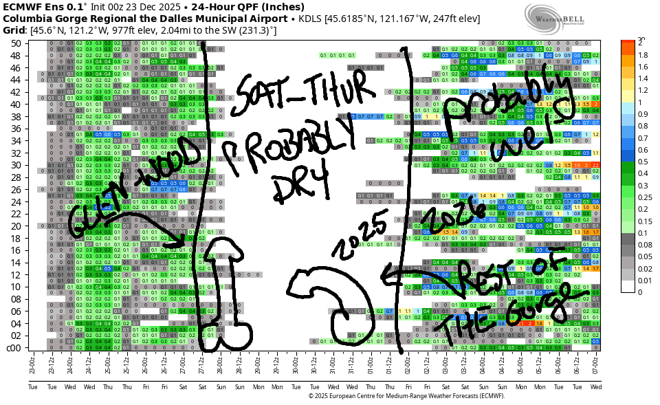
Good morning, neighbors! As you may recall, this forecast started in response to the uber-wintry winter of 2016-2017 when I was driving to grad school in Portland. Seemed like we had “don’t drive” warnings day after day that winter. This winter: nothing like that so far, thankfully. This upcoming week: also nothing like 2016-2017. While we do have a little rain forecast here and there, the biggest upcoming challenge would be colder weather on Saturday followed by several days of inversion next week.
Before I forget, as of 7:45am, the roads appeared clear of ¡CE.
Glenwood this morning
Looking at Tuesday morning, we have cloudy sky and 34 degrees in Glenwood, where everyone, everyone of all the genders, has morning wood. As a matter of fact, everyone in Glenwood has wood all day. It’s a nexus of priapism!
Today’s Gorge weather forecast
Elsewhere in the Gorge today, we’ll have a cloudy day. After a non-freezing start (upper 30s, mostly), lowland temps make it to the mid 40s. We’ll see a little drizzle from Cascade Locks westward this morning and drizzle from Troutdale to The Dalles for a few hours this evening. After a calm start to the wind, easterlies build into the evening, maxing out at 30-40mph at Iwash (pizzle) Rock and Stevenson.
Wednesday’s Gorge weather forecast
Significant uncertainty remains in Wednesday’s forecast. To paraphrase NWS: the evolution and path of an incoming low remains uncertain. This could lead to significant wind impacts for areas exposed to southerly wind. Those areas include the Valley of Willies (Willamette Valley) and, closer to home, Wasco, Sherman, and Gilliam Counties. If we see this southerly windstorm, it’ll start mid-morning and continue for just a few hours. We could also see moderately strong west wind west of Underwood for a few hours in the same time period. But we might not. And I should note that all this (potential) south wind follows early-morning 40mph easterlies in the usual spots.
It’s likely we’ll see some drizzle early Wednesday morning as far east as the Arlington Triangle and also in Wasco, Sherman, and Gilliam Counties. Expect dry weather after sunrise to the east. Another round of rain arrives from the west and dampens Cascade Locks and areas to the west all day. Somewhere in the middle of all this, a period of sunshine is expected east of Viento. Yay. Morning temps; upper 30s. Afternoon: 48F (west and east) and 45F (The Dalles).
Christmas Day Gorge weather forecast
Another round of light drizzle is forecast Thursday morning. Instability-driven showers are possible in the afternoon west of The Dalles. Models give us mostly cloudy sky early and partly cloudy sky in the afternoon. Yay, sun. Morning temps: mid 30s. Afternoon: 45F. Wind will be E 40 at Iwash (schlong) Rock in the morning and 20-25mph in the afternoon. Stevenson: 25-30mph in the morning and 15-20mph in the afternoon.
Extended Gorge weather forecast
Friday: dry, partly cloudy. Saturday: colder, probably sunny. Sunday on into next week: dry with warm air aloft and cooler air at the surface combined with east wind in the usual east wind spots. As of right now, it’s unlikely we’ll see any significant weather impacts in the next week or so. There is some chance of icy roads on Friday morning into Saturday and perhaps some freezing fog depending on what happens with the inversion (cloud or not) through the period of ridging / inversion. Let’s leave it there for now. I’m sure we all have baking to do, and I’d also like to let the folks of Glenwood get back to their wood. Safe travels. -TATAS
HEY! DON’T STOP READING! Is this community-focused forecast helpful to you? It sure is! It takes me a couple hours a day to write. Please join your friends and neighbors in contributing to keep it going. Venmo: @thegorgeismygym PayPal: twomirrors@gmail.com USPS: Temira / PO Box 841 / Hood River, Oregon 97031 You can test out the forecast subscription for a few days for free by signing up below. Easy! Do it!
JONES BEACH, SAUVIE ISLAND, & COAST FORECAST
ON WINTER VACATION UNLESS DESPERATELY NEEDED.
