

MT HOOD SNOW FORECAST

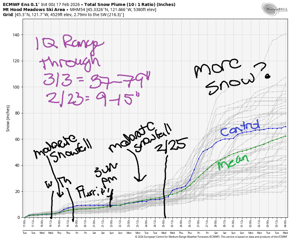
Hey skiers and snowboarders! Chilly weather has finally made an appearance on Mt. Hood – at 6500′ this morning, it’s only 12 degrees! Another 3” of fresh snow fell on the slopes over the last 24 hours. We’ll take it! Light and intermittent snow flurries are in the forecast through the end of the week with the highest snow potential on Wednesday night and Sunday night. Intraquartile range through next Monday is 9-15”, and through 3/3, it’s 37-79”.
Short term Mt Hood snow forecast
This morning (it’s Tuesday) brings flurries with partly cloudy weather possible midday. The snow level will be 500-1000′ in the morning, 1500′ in the afternoon, and 0-500′ overnight. Temps at 5000′ max out in the mid 20s. Under 1” of new snow is forecast today. Wind will be SW 15-25 in the morning, W 10 in the afternoon, and WNW 20-25 after midnight.
On Wednesday, we’ll have light snow in the morning and slightly heavier snow overnight. The snow level will be 0-500′ in the morning, 1000-1500′ in the afternoon, and 0′ after midnight. Temps max out in the low 20s at 5000′. During the day, we’re expecting 0.1” water equivalent (WE), for an inch of dry snow. Overnight, 0.1” to 0.4” WE is forecast for 1-5” additional snow – hopefully that range will shrink in tomorrow’s forecast. Wind on Wednesday: WNW 20-25 in the morning, W 10 in the afternoon, and variable to 15 overnight.
Extended Mt Hood Snow Forecast
Thursday starts cloudy with flurries and turns partly high overcast. The free air freezing level will be 0′ with temps maxing out in the mid to upper teens. A few flurries are possible, but no measurable accumulation is forecast. Wind: 10mph or less from various directions all day. Friday starts mostly clear and sees increasing clouds overnight with a trace of snow possible. The free air freezing level starts at 0′ and rises to 2000′. Wind will be W 10mph in the morning, SW 5-10 in the afternoon, and S 10-20 overnight.
Here’s the extended forecast: somewhat warmer, but dry weather is forecast on Saturday with moderate SE wind. Sunday looks sunny early and cloudy later with the potential for heavy snow overnight; that said, temps look marginal, so we’ll keep a close eye on this. Total moisture for next week does appear to be dropping some, but the potential for heavy snowfall still exists. Fingers crossed!
Was that helpful? I knew it was! Guess what? All of this crucial work – from your personal wind and snow reports to the invaluable TATAS updates – is made possible by my relentless efforts. Maintaining this labor of love isn’t easy. Each daily forecast takes hours. Website hosting, weather model access, and back-end admin work takes time and money. That’s where you come in.
YOUR CONTRIBUTION MAKES A DIFFERENCE
- SUPPORT ACCURATE, HYPER-LOCAL WEATHER FORECASTING
- ENABLE ACCESS FOR ALL, EVEN THOSE WITH LESS MEANS
- SUPPORT A COOL HUMAN WHO WORKS HARD SO YOU CAN PLAY
Take a moment to click one of the buttons below. Donate $19.99 or more (how much does this forecast enhance your life?) and get the email in your inbox. Whether it’s a renewing subscription (auto-renew) or a one-time donation, every contribution makes a real difference. Help me keep this labor of love alive, so we can all continue playing, commuting, and living in the Gorge with peace of mind and the best weather forecasts possible. Thank you!


Hood River, Oregon 97031


GORGE WIND FORECAST
If you’re still seeing yesterday’s and it’s after 9am, try opening this in an incognito window
SHORT-TERM gorge wind forecast
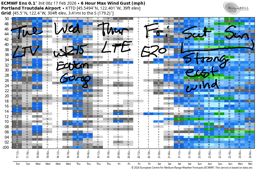
Hi friends! Once again, not much to talk about. Next chance of a big day is Saturday and also perhaps Sunday morning when an offshore low combines with inland cold for a period of strong east wind.
Tuesday started with light offshore flow and pressures of 29.38/29.39/29.42. Wind was under 10mph. As a weak system moves through today, west wind returns at 10-13mph, strongest from Lyle to Celilo. River flow over the last 24 hours was 158-185kcfs, river temp is 41.9F, and high temp forecast is 43F.
RIVER FLOW FOR SITES BETWEEN AVERY (EAST OF THE DALLES) AND RUFUS: CLICK HERE FOR JOHN DAY DAM FLOW.
RIVER FLOW FOR SITES BETWEEN STEVENSON AND DOUG’S BEACH (WEST OF THE DALLES): CLICK HERE FOR THE DALLES DAM FLOW

LONGER-TERM gorge wind forecast
Wednesday starts with light onshore flow, under 10mph. Afternoon wind rises to west 12-15mph between Rufus and Threemile with lighter wind elsewhere. High temp: 43F and partly cloudy. Thursday starts with light east wind that barely moves the needle. Afternoon brings easterlies at 10-15mph at Iwash (rooster) Rock and Stevenson. High temp: 43F and partly cloudy.
Looking at the extended forecast… Friday brings easterlies at 20mph. Stronger east wind, perhaps 50mph, is possible on Saturday, lingering into Sunday morning if everything lines up just right. Stay warm out there!
BARE BONES HOOD RIVER WEATHER FORECAST
Clouds with drizzle down low and snow/snain higher early, partly cloudy weather midday, showery this evening with rain down low and snow above 1500′. Temps start in the low 30s and rise to the low 40s. Light and variable wind. 89% chance of rainbows. Wednesday brings light snow in the morning and rain turning to snow overnight. 1-4” possible depending on location. Temps start in the upper 20s and rise to the low 40s. Light westerlies. 98% chance of rainbows. Thursday brings a few flurries early then partly cloudy sky. Temps start near 30 and rise to the low 40s. Light easterlies. 1% chance of rainbows.
TEMIRA’S AWESOME TRAVEL ADVISORY SERVICE
HYPERLOCAL WEATHER FORECAST FOR THE COLUMBIA GORGE
THE DALLES, HOOD RIVER, WHITE SALMON, TROUT LAKE, STEVENSON, CASCADE LOCKS, PARKDALE, ODELL, HUSUM, BZ, MILL A, WILLARD, GOLDENDALE, RUFUS, ARLINGTON, boardman
Good morning, neighbors! Colder weather has finally arrived to the Gorge. From my house this morning, I can see a little snow at the top of Underwood Mountain and a little less snow at lower elevations. At my house: ZERO SNOW. Chilly, snow-conducive weather sticks around for much of this week, but there isn’t all that much moisture around. Best chance of measurable snow will be Wednesday night. Do be prepared for icy roads this week as temps drop below freezing all the way down to the Nch’i Wana.
Glenwood this morning
Up in Glenwood this morning, it’s 29F. That puts Glenwood in good company: temps around the Gorge range from 27F (Parkdale) to 36F (Stevenson). Many areas may have icy roads, so take it easy out there. So far this morning, no !CE.
Tuesday’s Gorge weather forecast
Tuesday starts off cloudy and ends partly cloudy, although models do maintain an anomalous precip blob (technical term) between Hood River and The Dalles Tuesday evening, likely due to instability. Above 1500′, that blob could drop some evening snow or blobby rain (aka “snain”). Down lower, rain is likely. Today’s wind: light and variable becoming west 10mph. Overnight, the clear sky allows temps to drop below freezing all through the Gorge.
Wednesday’s Gorge weather forecast
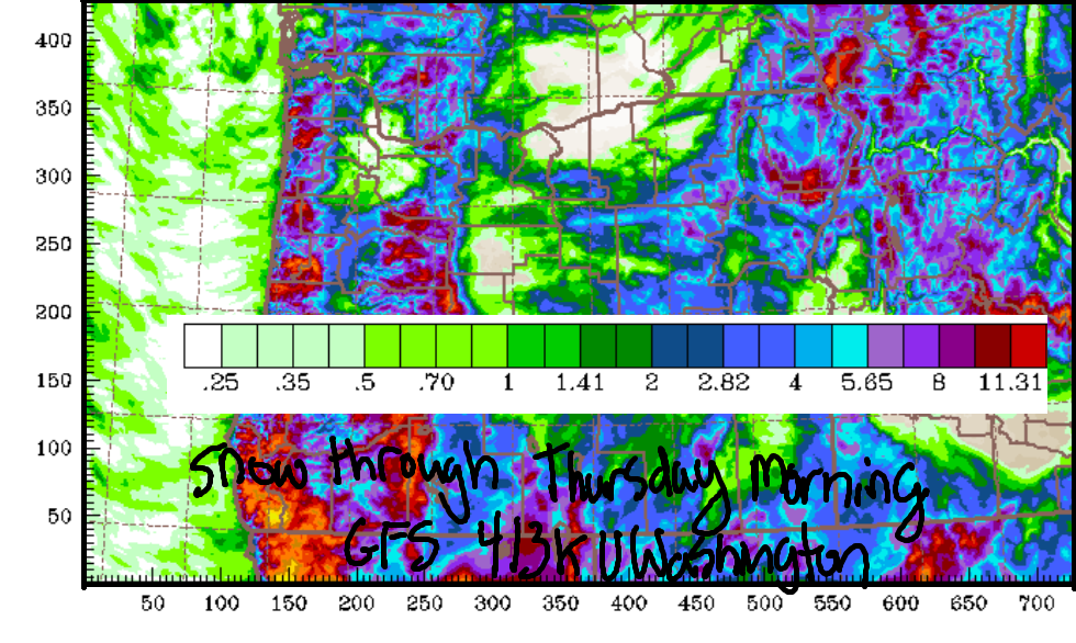
This sets us up for light snowfall Wednesday morning west of Hood River through 10am with light precip extending east to Rufus, south into south Wasco, and north to Goldendale mid-morning. Morning temps: upper 20s in the lowlands. With the snow level hovering below 1500′ all day, elevated locations could pick up an inch or so. Down lower, temps rise to the low 40s and the snow switches to rain. Wind will be light westerly early and W 10-15mph in the afternoon. Overnight, Clouds return as does some moisture and colder air. The snow level falls from 1500′ down to the surface as 850mb temps drop to -10C.
Thursday’s Gorge weather forecast
This sets us up for an inch or two of snow overnight Wednesday into Thursday morning as far east as perhaps Rowena or The Dalles and also in South Wasco County. Morning temps will be around 30F, but by the afternoon, they’ll rise to the low 40s in the lowlands. Snow melts. Wind: light easterly. Sky: partly cloudy in the afternoon.
Extended Gorge weather forecast
Overnight into Friday, roads refreeze thanks to limited cloud cover. After a partly Nothing start, the sky turns partly high overcast with plenty of filtered sun. A few sprinkles or flurries are possible overnight Friday into Saturday. Saturday looks dry. Sunday daytime looks dry. Heavier moisture is possible, but not promised, on Sunday night. We’ll keep a close eye on that. As of this morning, the timing looks good for rain and bad for snow/ice. Beyond that… nothing too concerning, at least for now. Safe travels. -TATAS
HEY! DON’T STOP READING! Is this community-focused forecast helpful to you? It sure is! It takes me a couple hours a day to write. Please join your friends and neighbors in contributing to keep it going. Venmo: @thegorgeismygym PayPal: twomirrors@gmail.com USPS: Temira / PO Box 841 / Hood River, Oregon 97031 You can test out the forecast subscription for a few days for free by signing up below. Easy! Do it!
JONES BEACH, SAUVIE ISLAND, & COAST FORECAST
ON WINTER VACATION UNLESS DESPERATELY NEEDED.
