

MT HOOD SNOW FORECAST

Hey skiers and snowboarders! We still have snow in the forecast for Wednesday, although the amount we’re expecting has fallen some. If we’re lucky, we’re going to pick up about a foot of new. That sets us up for very warm weather next Friday through Monday when temps on the slopes will climb to near 50 degrees. Pack some sunscreen in your weekend ski bag, and wax those skis with yellow!
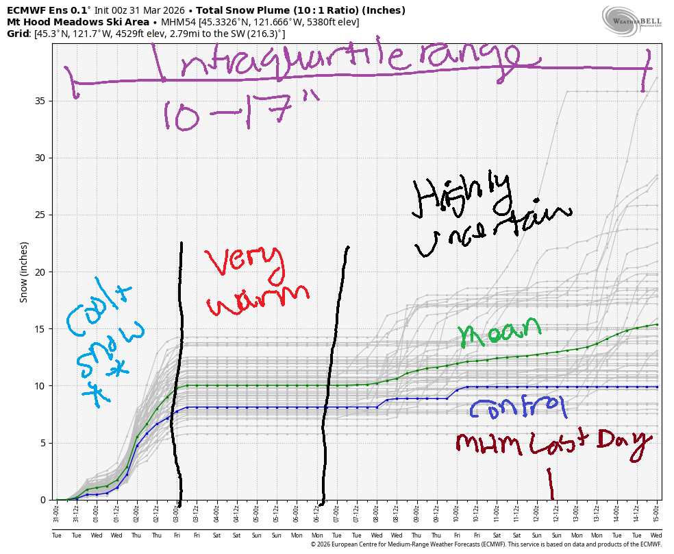
Short term Mt Hood snow forecast
Tuesday will be cloudy and cool with a few snow flurries. The snow level will be 2000′ early, 3500′ in the afternoon, and 3000′ overnight. About 0.05” water equivalent (WE) is forecast during the day for a trace of new. Same overnight. Wind will increases from SW 10-15 this morning to SW 25-40 overnight. Temps at 5000′ max out around 33F. Snow surface: frozen granular, and it probably won’t soften too much with these clouds.
Wednesday will be snowy all day. The snow level starts around 3000′, rises to 4500′ in the afternoon, and falls to 2000′ after midnight. During the day, we’re expecting 0.5” WE for about 5” new snow. Overnight, about 0.2” to 0.4” WE is forecast for 2-4” more. The ECMWF calls for a bit more: ensembles are predicting 1.0” to 1.3” WE for 10-13” total snowfall. Wind will be SW 25-40 in the morning, WSW 20-30 in the afternoon, W 25 in the evening, and WNW 20-30 after midnight. Temps max out around 33F midday before falling to 25F overnight.
Extended Mt Hood Snow Forecast
Thursday starts with a few flurries and quickly turns partly cloudy to mostly clear. The snow level will be 2000′ in the morning, and the free air freezing level will rise to 4000′ after midnight. Just a trace of snow is forecast in the morning. Wind: WNW 20-30 (not really a problem) in the morning, W 25 in the afternoon, and NW 15-20 after midnight. High temps rise to the upper 20s or low 30s.
Friday will be mostly clear. The free air freezing level rises to 5500′ in the afternoon and 6500′ overnight with temps at 5000′ rising to the upper 30s. Wind will be NW 15-20 early, light westerly in the afternoon, and SW 10 overnight. Saturday and Sunday look sunny and warm with light wind and temps rising to the upper 40s at 5000′. Uncertainty increases on Monday, and temps (probably) start falling, but snowfall does not appear to be in our future. Get it while you can!
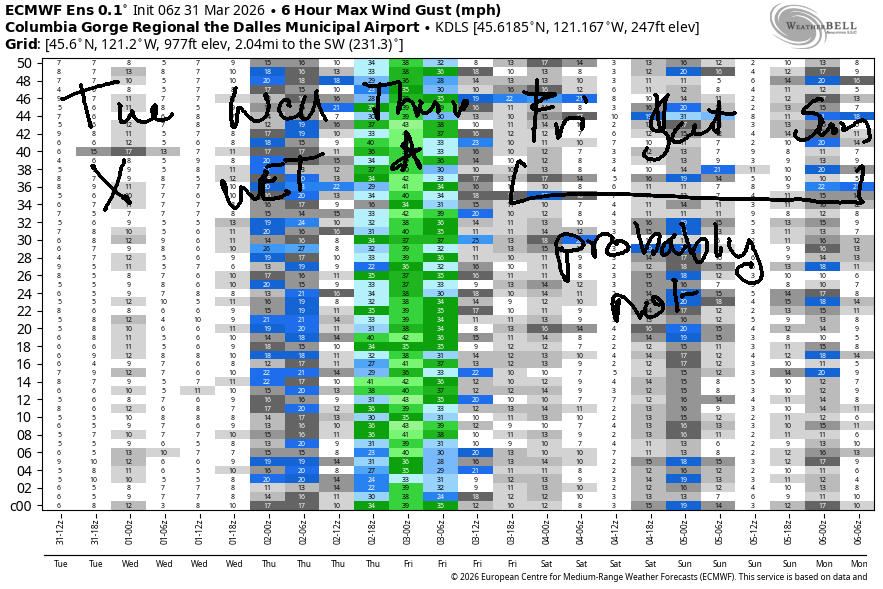
GORGE WIND FORECAST
If you’re still seeing yesterday’s and it’s after 9am, try opening this in an incognito window
SHORT-TERM gorge wind forecast
Hi friends! For the next five days, we have a couple rounds of light easterlies, a solid eastern Gorge west wind day (Thursday) and then (probably) light and variable wind for the following few days. Uncertainty increases on Monday and skyrockets on Tuesday. Sometime in the first half of next week, we could see a west wind cooldown day.
Tuesday isn’t going to bring much of anything. Easterlies will be 20mph or so at Iwash and Stevenson with 15mph at Viento this morning. By afternoon, Iwash turns light westerly. Stevenson and Viento drop to the light/variable zone. To the east of these locations: light wind all day. River flow over the last 24 hours was 219-240kcfs, river temp is 47.1F, and high temp forecast is 53F and cloudy.
RIVER FLOW FOR SITES BETWEEN AVERY (EAST OF THE DALLES) AND RUFUS: CLICK HERE FOR JOHN DAY DAM FLOW.
RIVER FLOW FOR SITES BETWEEN STEVENSON AND DOUG’S BEACH (WEST OF THE DALLES): CLICK HERE FOR THE DALLES DAM FLOW

LONGER-TERM gorge wind forecast
Wednesday looks downright wet and not very windy, at least not until the cold front swings through in the afternoon. Early wind will be calm. Stevenson and Iwash rise to 20mph mid-morning and drop off to early afternoon. When the front swings through, we’ll see gusty 16-19mph from Stevenson to The Dalles (closer to 30mph at Viento, probably), and gusty 20-25mph from Avery to Rufus. The wind eventually spreads farther east as the weather system moves through. Sometimes with this setup we get a short burst of stronger wind at the Hatch as the front passes; usually that’s accompanied by clear sky, and models call for clouds at the Hatch all day, so it seems unlikely. Just in case… keep a close eye on the river. High temp: 51F in Hood River and 56F in the desert with lots of rain and clouds and even some instability!
Thursday sees high pressure offshore, sunshine in the desert, and clouds on the west side. Ready, set, go! Models call for gusty 14-17mph in the cloudy western Gorge all day. To the east: Avery to Boardman starts at 24-27mph. Afternoon wind rises to gusty 29-33mph from Lyle to Threemile with 23-26mph farther east. Models do suggest the wind will fade after 5pm. Your sweet spot is mid-afternoon. High temp: 52F for Hood River, 57F in the desert, and mostly cloudy sky most of the day. As of this morning, Models suggest light/variable wind on Friday, Saturday, and Sunday as warm weather settles in over the entire Gorge. Uncertainty increases Monday, so I’ll leave you with this for now. Enjoy Thursday! I’m doing an online retreat, so I’ll be able to forecast but not join you!

BARE BONES HOOD RIVER WEATHER FORECAST
Overcast sky all day. Temps start in the upper 30s and rise to the low 50s. Light easterlies most of the day. Light westerlies later. No rainbows. Wednesday will be rainy. Temps start in the low 40s and rise to the low 50s. Light easterlies then light westerlies. 98% chance of rainbows. Thursday will be cloudy then partly cloudy with a few sprinkles prior to dawn. Temps start in the upper 30s and rise to the low 50s. Moderate westerlies. 0.5% chance of rainbows.
TEMIRA’S AWESOME TRAVEL ADVISORY SERVICE
HYPERLOCAL WEATHER FORECAST FOR THE COLUMBIA GORGE
THE DALLES, HOOD RIVER, WHITE SALMON, TROUT LAKE, STEVENSON, CASCADE LOCKS, PARKDALE, ODELL, HUSUM, BZ, MILL A, WILLARD, GOLDENDALE, RUFUS, ARLINGTON, boardman
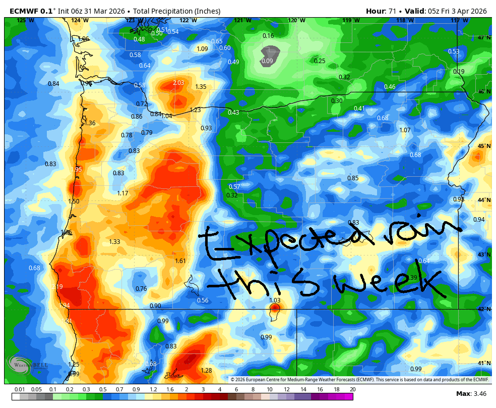
Good morning, neighbors! If you like cloudy weather, you’re going to like the next three days. If you’re hoping for sunshine, your hopes will be fulfilled Friday through Sunday. Waiting for blossoms? You don’t have long to wait! The most exciting weather stuff in the next few days is an actual soaking rain on Wednesday and nearly 70 degree weather this weekend.
Glenwood this morning
Know who’s nowhere near 70 this morning? Glenwood! They started the day at 29F, and everyone is knitting those red Resistance hats. Thank you for wearing your hat. Now that your head is warm, pick up the phone and make some calls!
Tuesday’s Gorge weather forecast
Tuesday’s weather will be good for lots of things. My day is going to include a lot of running around so I can focus on an online meditation retreat this week. I figure I’ll still do the forecast cuz someone decided the retreat shouldn’t start until 8:45am each day. SO LATE! We’ll have clouds today. Stevenson and Iwash will see easterlies at 20mph, but the rest of us will have light wind. A little drizzle is possible in Underwood (I can see it raining, so therefore it will rain) and areas west of Underwood for a few hours this morning. We keep the clouds and lose the drizzle this afternoon. Temps rise to +/- 53 degrees.
Wednesday’s Gorge weather forecast
Rain moves in overnight. By 12:01AM on Wednesday morning, rain will make it to Hood River. By 2:01am, the rain skips The Dalles and extends to the Tri-Cities. From 2am to 11am or so, even South Wasco, Sherman, and Gilliam Counties see some drizzle! Heavy rain pummels areas west of Hood River from 5am to 2pm (not a fun drive!). That heavy rain shifts east in the afternoon and extends all the way to the Tri-Cities (not a fun drive!). After 8pm, areas east of The Dalles start to dry out. Areas west of The Dalles hold on to some lingering showers. Up in the mountains, snow will accumulate on the passes especially in the evening. Daytime wind in the lowlands maxes out at 20mph near Stevenson and Iwash (pen*s) Rock before turning light westerly in the afternoon (which makes rainbows) and increasing overnight. High temps: 51F to the west, 55F in The Dalles, and 57F in the desert. That’s after lows near 40F thanks to cloud cover.
Thursday’s Gorge weather forecast
A few lingering showers prior to sunrise Thursday give way to a mostly cloudy and breezy day. Given how windy it will be, frost is unlikely, but we can’t totally rule out sub-freezing temps in some of the more sheltered areas. Otherwise: 34-40F to start. 52-59F to finish. Wind is the most interesting thing happening Thursday: 15-20mph west of Lyle and 25-35mph from Lyle to the Arlington Triangle and 25-30mph east of the Triangle. This will make tumbleweeds and boardheads happy. Everyone else: not so much.
Extended Gorge weather forecast
Everyone else will therefore like Friday, Saturday, and Sunday when we’re expecting sunshine, light wind, and 60+ degrees. That’s all for now. My cat is demanding I feed her. Safe travels. -TATAS
HEY! DON’T STOP READING! Is this community-focused forecast helpful to you? It sure is! It takes me a couple hours a day to write. Please join your friends and neighbors in contributing to keep it going. Venmo: @thegorgeismygym PayPal: twomirrors@gmail.com USPS: Temira / PO Box 841 / Hood River, Oregon 97031 You can test out the forecast subscription for a few days for free by signing up below. Easy! Do it!
JONES BEACH, SAUVIE ISLAND, & COAST FORECAST
ON WINTER VACATION UNLESS DESPERATELY NEEDED.

Leave a Reply