

MT HOOD SNOW FORECAST

Hey skiers and snowboarders! Another dry day is in the forecast, but a little bit of snow is in the cards for tonight. Additional light, wet snowfall is in the cards into Thursday morning when the snow is likely to switch to rain. Ensembles (mostly) agree on a dry weekend followed by another round of light rain on Monday. Extended forecast: dry and warm through at least the 9th of February. After that: too much uncertainty to guess at things, as you can see from the spaghetti model forecast for Mt Hood snow.
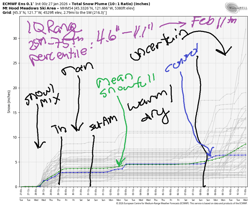
Short term Mt Hood snow forecast
Tuesday started off with high clouds. Clouds increase this afternoon, and light, wet snow arrives this evening. The snow level will be 6500′ this morning, 7000′ this afternoon, 5000′ when the precip arrives, and 4000′ after midnight. We’re expecting about 0.1”, maybe 0.2” water equivalent (WE) tonight for perhaps an inch of dense snow at 5000′. Wind today will be S 10-20 all day, SW 15-25 in the evening, and WSW 35-45 after midnight.
Snow Wednesday morning briefly gives way to clear sky in the afternoon and snow/mixed precip overnight. The snow level will be 4000′ most of the 24 hour period, but temps may rise above 32F overnight and make the snow even wetter. About 0.2” WE is forecast in the morning for 1-2” at 5000′. Another 0.2” WE is forecast in the afternoon for another 1-2” snow at 5000′. Overnight, 0.2” WE is forecast. With temps fluctuating, we may see just an inch of wet snow. Wind: WSW 35-45 in the morning, SW 25-35 in the afternoon, and SW 15-25 overnight.
Extended Mt Hood Snow Forecast
Models suggest temps will warm on Thursday and take the snow level from 4000′ in the morning to 6500′ in the afternoon and 8000′ overnight. It’s unclear how much precip we’ll pick up in this time frame, but it’s going to be rain. Wind: SW or W 20-25 depending on the time of day. Friday looks cloudy with up to 0.1” WE mixed precip or (more likely) drizzle. Temps max out in the upper 30s. Wind will be SW 20-35.
As of this morning, the forecast for next weekend looks dry and warm on Saturday and somewhat cooler and probably dry on Sunday. It’s possible we could see a little snow on Monday. After that: warm, potentially quite warm (850mb temps at 7-10C) and probably sunny. Winter is broken. Get up and ride some groom and take up skate skiing – the skating has been phenomenal, and will continue to be the best thing going. See you on the snow!
Was that helpful? I knew it was! Guess what? All of this crucial work – from your personal wind and snow reports to the invaluable TATAS updates – is made possible by my relentless efforts. Maintaining this labor of love isn’t easy. Each daily forecast takes hours. Website hosting, weather model access, and back-end admin work takes time and money. That’s where you come in.
YOUR CONTRIBUTION MAKES A DIFFERENCE
- SUPPORT ACCURATE, HYPER-LOCAL WEATHER FORECASTING
- ENABLE ACCESS FOR ALL, EVEN THOSE WITH LESS MEANS
- SUPPORT A COOL HUMAN WHO WORKS HARD SO YOU CAN PLAY
Take a moment to click one of the buttons below. Donate $19.99 or more (how much does this forecast enhance your life?) and get the email in your inbox. Whether it’s a renewing subscription (auto-renew) or a one-time donation, every contribution makes a real difference. Help me keep this labor of love alive, so we can all continue playing, commuting, and living in the Gorge with peace of mind and the best weather forecasts possible. Thank you!


Hood River, Oregon 97031


GORGE WIND FORECAST
If you’re still seeing yesterday’s and it’s after 9am, try opening this in an incognito window
SHORT-TERM gorge wind forecast
Hi friends! Easterlies continue… Today, Tuesday, looks like the strongest of the next five. Pressures at 6am were 30.17/30.33/30.41 for a rockin’ offshore gradient. In the pre-dawn light, Iwash (Rooster) was reading 50mph, Stevenson 35mph, and Viento 23mph. Stevenson may bump up near 40mph at times. Otherwise, you can expect the wind to hold steady all day. River flow over the last 24 hours was 144-212 kcfs, river temp is 41.0F, and high temp forecast is 39F with high clouds in the morning and thicker clouds in the afternoon.
Wednesday starts with 20mph at Stevenson and 15mph at Iwash as a weak weather system moves inland. The wind drops to 15mph at Stevenson in the afternoon and falls to less than 10mph at Iwash. High temp: 44F with clouds and drizzle.
RIVER FLOW FOR SITES BETWEEN AVERY (EAST OF THE DALLES) AND RUFUS: CLICK HERE FOR JOHN DAY DAM FLOW.
RIVER FLOW FOR SITES BETWEEN STEVENSON AND DOUG’S BEACH (WEST OF THE DALLES): CLICK HERE FOR THE DALLES DAM FLOW

LONGER-TERM gorge wind forecast
Thursday starts with 25mph at both Iwash and Stevenson and falls to 15mph in the afternoon. Along with the light easterlies, you’ll have clouds, rain, and highs in he mid 40s. Friday’s wind looks lighter, probably under 15mph.
Thinking about the weekend? The current forecast is 30-35mph easterlies on Saturday and less east wind on Sunday. If you’re headed out, dress warmly, have an emergency plan, and keep an eye on your buddies!
BARE BONES HOOD RIVER WEATHER FORECAST
Partly high overcast this morning with partly Nothing in some areas. Cloudy later. Rain/ice overnight. Temps start in the upper 20s and rise to the upper 30s. Light easterlies. No rainbows. Wednesday will be cloudy with rain. Temps start in the low 30s and rise to the mid 40s. Light easterlies. 1% chance of rainbows. Thursday will be rainy temps start in the upper 30s and rise to the mid 40s. Light easterlies. 4% chance of rainbows.
TEMIRA’S AWESOME TRAVEL ADVISORY SERVICE
HYPERLOCAL WEATHER FORECAST FOR THE COLUMBIA GORGE
THE DALLES, HOOD RIVER, WHITE SALMON, TROUT LAKE, STEVENSON, CASCADE LOCKS, PARKDALE, ODELL, HUSUM, BZ, MILL A, WILLARD, GOLDENDALE, RUFUS, ARLINGTON, boardman
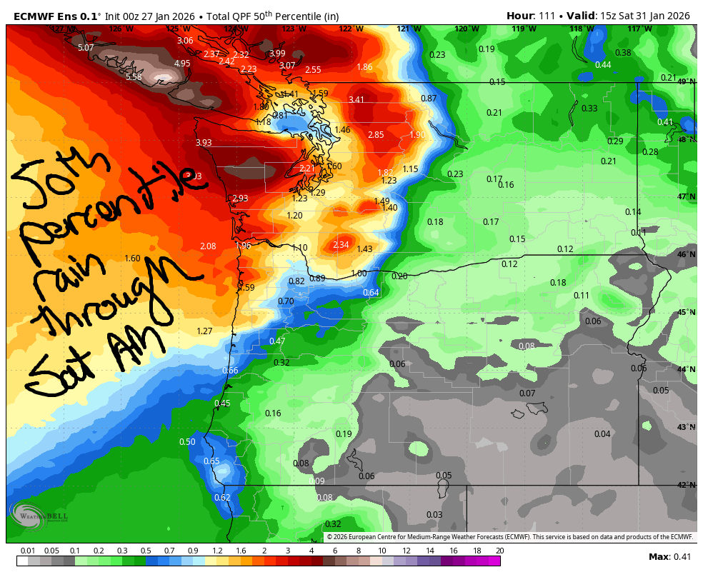
Good morning, neighbors! FINALLY! Something is going to happen in the weather! Our long-lasting super ridge of high pressure breaks down today and allows a little precipitation inland tonight (Tuesday night). There’s a decent chance some areas will see freezing rain into Wednesday morning. From Wednesday on into Friday, we’ll see intermittent periods of rain. Models continue to struggle with rain totals, but the 50th percentile precip image gives you a decent understanding of what’s coming. Nothing too dramatic.
This morning’s math activity
Also lacking drama: the roads this morning. No sightings of ¡CE so far today – they’re too busy terrorizing Minnesota to take note of the little ol’ Gorge (for now). Did you know that there is currently 1 ¡CE agent for every 142 people in Minneapolis? To achieve the same ratio, we’d only need 60 of them in Hood River. Let that sink in. If you’d like to know what to do if you see them, watch the ACLU’s webinar from Monday. You can also take a Migra Watch training through Portland Immigrant Rights Coalition. But as I said, no drama on the roads this morning, thankfully!
Glenwood this morning
Speaking of dramatic… Glenwood is embracing the role of drama queen this morning with a low temperature of 19 degrees. And we’re all supporting that dynamic by cheering for their sub-20F performance. Good job, Glenwood. We’re proud of you! Elsewhere: 18-21 in Dufur, 20F in The Dalles (brrrr), mid 20s in the Upper Valley, and low 30s in the east wind zones. East wind today: 50mph at Iwash and 30-40mph near Stevenson with lighter wind elsewhere. High temp: near 40 all across the lowlands.
Today’s Gorge weather forecast
Clouds increase during the day Tuesday. Rain starts around 7pm for areas west of Mosier and also in south Wasco County. Light drizzle extends as far east as the Tri-Cities around 10pm. Clouds will have trapped some of the daytime heating, and temps won’t fall much overnight. Dewpoints will be in the mid 20s. This leaves us right on the edge for rain/freezing rain. We’re expecting less than 0.1” precip prior to 1am, so not too much drama but enough for potentially slick roads in some areas.
I’d say icing is most likely east of Biggs (a trace), in south Wasco and Sherman Counties (a trace), the Upper Valley, BZ, Trout Lake, Glenwood, and in all the hills above 1000′. After 1am, precip ends east of The Dalles, but intensity increases to the west. Parkdale, BZ, Trout Lake, Willard, Middle Mountain, and other associated areas could pick up additional freezing rain. In the lowlands, I suspect temps will be too warm (right around freezing or a touch above) for ice on roads.
Wednesday’s Gorge weather forecast
Driving to the metro area Wednesday morning? Expect pouring rain west of Viento from 1am-7am followed by another round of moderate to heavy rain from 10am on into Thursday. Most of us will see a break in the rain from 7am-10am. Next up is another system late morning. Areas east of Rowena stay dry until 4pm or so when this system pushes east. After 10am, temps (should) rise above freezing and end the risk of ice. Wednesday afternoon temps rise to the low 40s. Wind will be E 15-20 near Stevenson, less than 20mph near Iwash, and light everywhere else.
Extended Gorge weather forecast
Models call for more rain on Thursday, but they’re all over the place on how much rain we’ll see. Expect just-rain-not-ice as morning temps start in the upper 30s and the snow level holds above 4000′ all day. Afternoon temps rise to the low-mid 40s. East wind: 25mph in the usual spots in the morning and 15mph in the afternoon. Light wind away from Iwash (wanker) Rock and Cascade Locks. Clouds and light, intermittent drizzle are likely Friday. Saturday and Sunday look warmer and (probably) dry, but we’ll revisit this as models aren’t certain. It’s likely we’ll see another round of light rain on Monday followed by dry weather next week. The Most Boring Winter Weather Ever continues… Safe travels. -TATAS
HEY! DON’T STOP READING! Is this community-focused forecast helpful to you? It sure is! It takes me a couple hours a day to write. Please join your friends and neighbors in contributing to keep it going. Venmo: @thegorgeismygym PayPal: twomirrors@gmail.com USPS: Temira / PO Box 841 / Hood River, Oregon 97031 You can test out the forecast subscription for a few days for free by signing up below. Easy! Do it!
JONES BEACH, SAUVIE ISLAND, & COAST FORECAST
ON WINTER VACATION UNLESS DESPERATELY NEEDED.
