

MT HOOD SNOW FORECAST

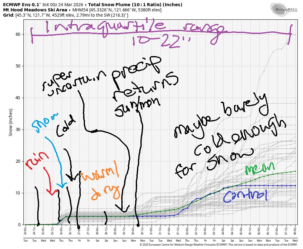
Hey skiers and snowboarders! A solid round of rain is in the forecast today with a trace of snow at the tail end of it. It’s possible we’ll pick up a couple inches of snow on Wednesday as a consolation. Thursday looks sunny and cool, and warm weather returns on Friday. Model range is enormous on Saturday and Sunday as those models struggle to resolve the timing of the next system. Once that arrives, we’re set for a cooler, wetter pattern for a week or so. Temps look marginal for snowfall at 5000′. The winter that wasn’t continues!
Short term Mt Hood snow forecast
Looking at Tuesday…. Mt. Hood started off cloudy. Rain arrives by 11am and turns heavy in the afternoon. Overnight temps fall, but the precipitation shuts off. The snow level today will be 10,000′ early, 6000′ around closing time, and 2500′ after midnight. About 0.7” rain is expected prior to 5pm. Another 0.4” water equivalent (WE) arrives as the snow level is dropping, but that’ll still be rain at 5000′. Overnight, just 0.1” WE is forecast for up to an inch of snow at 5000′. Wind will be WSW 40-45 in the morning, SW 30-55 most of the day (not a problem for most lifts – just the highest won’t run), and W 40 after midnight. Snow conditions today start with a mix of frozen and soft granular. Everything turns to slush this afternoon.
Wednesday could have a few orographic (terrain-enhanced) snow flurries early, but clear sky quickly takes over. Sometime mid-afternoon, another system arrives with a bit of snow. The snow level will be 2500′ early, 1500′ in the afternoon, and as low as 1000′ under clear sky overnight. Up to 0.2” WE is forecast in the afternoon and evening for a couple inches of new snow. Wind will be W 40 in the morning, W 30 in the afternoon, and NW 15-20 after midnight.
Extended Mt Hood Snow Forecast
Thursday looks sunny and cool, and it just might be a fun groomer day if we really do pick up a couple inches of new. The free air freezing level will be 1000′ early, 3000′ in the afternoon, and 6000′ after midnight. Temps max out near 32F after starting in the low-mid 20s. Wind will be NW 15-20 early, SW 5-10 in the afternoon, and variable to 10 overnight.
Friday starts sunny and turns high overcast. The freezing level rises to 10,000′ in the afternoon after starting around 6000′. That puts high temps at 5000′ around 442F. Wind will be light and variable all day. Model spread amplifies for the weekend, and it’s impossible to say for sure what will happen. It does look like some precipitation (not a ton) may arrives sometime on Sunday. Beyond that: cool and showery for the next week or so with quite a bit of uncertainty around both temps and precipitation quantity. Intraquartile range for snowfall through April 8th is 10-22”. See you on the snow!
Was that helpful? I knew it was! Guess what? All of this crucial work – from your personal wind and snow reports to the invaluable TATAS updates – is made possible by my relentless efforts. Maintaining this labor of love isn’t easy. Each daily forecast takes hours. Website hosting, weather model access, and back-end admin work takes time and money. That’s where you come in.
YOUR CONTRIBUTION MAKES A DIFFERENCE
- SUPPORT ACCURATE, HYPER-LOCAL WEATHER FORECASTING
- ENABLE ACCESS FOR ALL, EVEN THOSE WITH LESS MEANS
- SUPPORT A COOL HUMAN WHO WORKS HARD SO YOU CAN PLAY
Take a moment to click one of the buttons below. Donate $19.99 or more (how much does this forecast enhance your life?) and get the email in your inbox. Whether it’s a renewing subscription (auto-renew) or a one-time donation, every contribution makes a real difference. Help me keep this labor of love alive, so we can all continue playing, commuting, and living in the Gorge with peace of mind and the best weather forecasts possible. Thank you!


Hood River, Oregon 97031


GORGE WIND FORECAST
If you’re still seeing yesterday’s and it’s after 9am, try opening this in an incognito window
SHORT-TERM gorge wind forecast
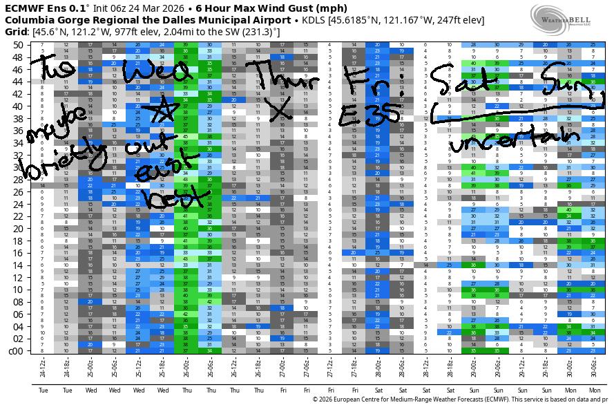
Hi friends! Heads up that the current is way up right now. Keep that in mind if you’re headed to the Rufus area the next couple of days. And yes, we have some wind in the forecast – best chance of solid, lasting westerlies will be Wednesday afternoon between Avery and Boardman.
Tuesday morning started with pressures of 29.93/29.92/29.92 and light/variable wind. We’ll see a brief period of east wind at 10-15mph near Stevenson this morning. By noon, the wind turns 180 degrees as a weather system moves in. From Multnomah Falls to Viento, you’ll find gusty 15-20mph. It’s possible the wind will make it to the Hatch, but if it does, it’ll be 1) up-and-down and 2) rainy. Head east of The Dalles for gusty 20-25mph that only lasts for a couple hours between Avery and Boardman early afternoon before dying off in the face of incoming rain. River flow over the last 24 hours was 233-261kcfs, river temp is 46.2F, and high temp forecast is 58F in Hood River and 63F in the desert.
RIVER FLOW FOR SITES BETWEEN AVERY (EAST OF THE DALLES) AND RUFUS: CLICK HERE FOR JOHN DAY DAM FLOW.
RIVER FLOW FOR SITES BETWEEN STEVENSON AND DOUG’S BEACH (WEST OF THE DALLES): CLICK HERE FOR THE DALLES DAM FLOW

LONGER-TERM gorge wind forecast
Another weak system moves through on Wednesday, and strong offshore high pressure builds behind it. Morning wind will be 7-10mph west of The Dalles and 15-18mph east of The Dalles all the way to Boardman. Afternoon sees Stevenson-Hood River climb to gusty 15-18 (a short period of stronger wind is possible if the clouds burn back more than expected). From Mosier to Boardman, the wind slowly builds to 28-31mph. High temp: 53F in Hood River (rainy until 8pm) and 60F out in the desert with mostly clear sky.
Thursday’s weather looks nice, and the wind will be perfect for doing things that require zero wind. We’re expecting light/variable to calm conditions all day long. High temp: mid 50s. Friday brings a around of easterlies. Max wind will be 35-40mph near Iwash, but you’ll probably find enough to get you on the water at Viento, Home Valley, and Stevenson. High temp: 60ish. Uncertainty skyrockets on Saturday and Sunday to the point that it’s impossible to make a forecast. Generally speaking, the wind direction looks westerly, but that’s all I can say at this point. Have an awesome day out there!

BARE BONES HOOD RIVER WEATHER FORECAST
Cloudy today with rain from 11am on into the evening. Temps start in the upper 40s and rise to the upper 50s. Calm wind early. Light to moderate westerlies later. 98% chance of rainbows. Wednesday will have a few morning showers then light rain, then partly cloudy sky. Temps start in the low 40s and rise to the low 50s. Moderate westerlies. 99.7% chance of rainbows. Thursday will be partly cloudy then clear. Temps start in the mid 30s and rise to the mid 50s. Light and variable wind. No rainbows.
TEMIRA’S AWESOME TRAVEL ADVISORY SERVICE
HYPERLOCAL WEATHER FORECAST FOR THE COLUMBIA GORGE
THE DALLES, HOOD RIVER, WHITE SALMON, TROUT LAKE, STEVENSON, CASCADE LOCKS, PARKDALE, ODELL, HUSUM, BZ, MILL A, WILLARD, GOLDENDALE, RUFUS, ARLINGTON, boardman
Good morning, neighbors! Rain today! Rain! Yay! As I was writing this forecast, the rain had advanced to nearly Klatskanie. It’s coming! After a rainy day today, we’ll have showers and wind on Wednesday. Sunshine, frost, and calm conditions are in the cards for Thursday. Warming returns on Friday, when frost is possible again, but by the weekend, model uncertainty skyrockets.
Remember that Saturday the 28th is the next No Kings protest. You don’t have to protest against democratic backsliding and the consolidation of power in one person (although it’s a good idea). You can protest against war, income inequality, lack of access to healthcare, the fact that majority of benefits on recent tax cuts when to the top 10% of earners… lots of reasons to gather with friends and make your voice heard in a joyful way!
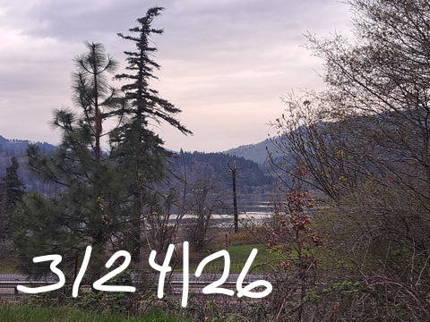
Glenwood this morning and today’s Gorge weather forecast
Speaking of joyful… everyone is joyful in Glenwood this morning because temps are nowhere near freezing: it’s 49F there to start the day. As I said earlier, rain is incoming. By 11am, we’ll have rain as far east as Mosier. By early afternoon, drizzle spreads to Idaho. Rain continues for many of us until 8pm. Cascade Locks, being extra special, holds on to drizzle until late evening. City-Country commuters will encounter very heavy rain west of Cascade Locks between 11am and 5pm. After a light/variable wind start, westerlies rise to 15-20mph west of the Dalles and 25-30mph east of The Dalles for a few hours this afternoon. Combine the wind and rain for inevitable rainbows. During all this rain, the snow level remains above 5000′. High temps: upper 50s in the west low 60s near The Dalles, and mid 60s in the desert.
Wednesday’s Gorge weather forecast
Overnight into Wednesday, the snow level falls to 2500′, and the sky clears. This will result in icy roads on the passes, and it could result in a few icy areas locally, but the lowlands will see temps in the low 40s early. It’s the not-windy, elevated spots that could see slick roads. For most of Wednesday, areas east of The Dalles will be mostly clear. To the west: at least partly cloudy. Showers are possible on and off to Rowena into the afternoon. High temps rise to the low 50s (west), upper 50s (The Dalles) and 60F (The Desert). Wind on Wednesday will be around 15mph west of Mosier and 25-35mph from Mosier to Boardman. Boardheads: happy. Board men: bored.
Thursday’s Gorge weather forecast
Clearing sky and dropping wind on Wednesday night leaves us with ideal radiational cooling on Thursday morning. Watch out for icy roads as the freezing level dips close to the Nch’i Wana. Also likely: frost above 500′ and potentially a light, patchy frost lower. By afternoon, sunshine returns. We all end up 55-57 degrees with light/variable wind.
Friday’s Gorge weather forecast
Clear sky Friday morning gives way to high clouds in the afternoon. Frost is, again, possible early. Wind forecast has easterlies at 30-40mph near Iwash (ding-dong) Rock and Stevenson with 10-15mph in the hills. Relatively warm, partly cloudy weather is likely Saturday, but model agreement is poor. Consensus does not exist for temps on Sunday, but more ensemble members call for “warm” than “cool”. Rain is likely to return at some point on Sunday and continue on and off into next week. Safe travels. -TATAS
HEY! DON’T STOP READING! Is this community-focused forecast helpful to you? It sure is! It takes me a couple hours a day to write. Please join your friends and neighbors in contributing to keep it going. Venmo: @thegorgeismygym PayPal: twomirrors@gmail.com USPS: Temira / PO Box 841 / Hood River, Oregon 97031 You can test out the forecast subscription for a few days for free by signing up below. Easy! Do it!
JONES BEACH, SAUVIE ISLAND, & COAST FORECAST
ON WINTER VACATION UNLESS DESPERATELY NEEDED.

Leave a Reply