

MT HOOD SNOW FORECAST

Hey skiers and snowboarders! Ski season is winding down, and today the wind is ramping up! For the rest of the week, other than today, we’ll have warm, sunny, not-so-windy weather on Mt Hood. Showers are possible this weekend, or even a few snow flurries. Beyond that… unless something noteworthy happens, this forecast will be on vacation through next fall. It’s been fun!
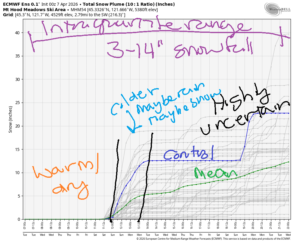
Short term Mt Hood snow forecast
Tuesday kicks off sunny and windy, windy enough to impact some lift operations at both Meadows and Timberline – all the higher lifts are currently on wind hold. While the wind will back off some today, it’s going to be marginal for getting those lifts at all. The free air freezing level falls from 10,000′ this morning to 8500′ overnight with max temps in the low 40s at 5000′. Wind will be WNW 35-40 this morning, WSW 20-30 this afternoon, and NW 10-15 after midnight. Snow surface: spring skiing.
Wednesday will be sunny all day. The free air freezing level will be 8500′ in the morning, 9500′ in the afternoon, and 9000′ after midnight. Temps max out around 40 degrees. Wind will be NW 10-15 in the morning, W 20 in the afternoon, and light overnight. No lift impacts are anticipated.
Extended Mt Hood Snow Forecast
Thursday will be sunny and calm with the freezing level around 10,000′. Temps rise to the low 50s at 5000′ in the afternoon. Friday looks similar, but will add some high clouds.
Cooler, potentially showery weather is forecast for the weekend. It’s not clear yet if we’ll see rain or snow showers or a mix of both; yesterday’s model runs actually called for some snow. Today’s deterministic GFS calls for rain showers, and the Euro is leaning towards snow. So… no clear outcome yet. It will be the last Meadows weekend for the season, so get up there either way! See you on the snow soon!
Was that helpful? I knew it was! Guess what? All of this crucial work – from your personal wind and snow reports to the invaluable TATAS updates – is made possible by my relentless efforts. Maintaining this labor of love isn’t easy. Each daily forecast takes hours. Website hosting, weather model access, and back-end admin work takes time and money. That’s where you come in.
YOUR CONTRIBUTION MAKES A DIFFERENCE
- SUPPORT ACCURATE, HYPER-LOCAL WEATHER FORECASTING
- ENABLE ACCESS FOR ALL, EVEN THOSE WITH LESS MEANS
- SUPPORT A COOL HUMAN WHO WORKS HARD SO YOU CAN PLAY
Take a moment to click one of the buttons below. Donate $19.99 or more (how much does this forecast enhance your life?) and get the email in your inbox. Whether it’s a renewing subscription (auto-renew) or a one-time donation, every contribution makes a real difference. Help me keep this labor of love alive, so we can all continue playing, commuting, and living in the Gorge with peace of mind and the best weather forecasts possible. Thank you!


Hood River, Oregon 97031


GORGE WIND FORECAST
If you’re still seeing yesterday’s and it’s after 9am, try opening this in an incognito window
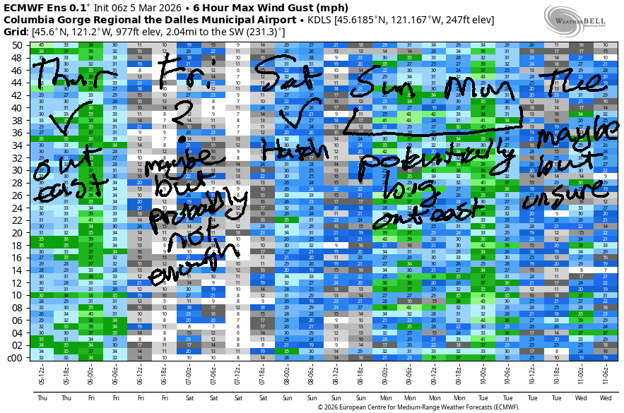
SHORT-TERM gorge wind forecast
Hi friends! It’s 7:15am as I’m writing this, and the whitecaps are BIG in front of my house already. It’s gonna be a good one today! Lighter westerlies, probably not enough, are forecast Wednesday followed by light wind Thursday and Friday. Keep your eye on the weekend; forecasts haven’t coalesced yet, but about 70% of the ensemble members give us solid westerlies both days.
When I woke up this morning (Tuesday), pressures were 30.12/29.96/29.87 for gradients of 0.18/0.09. MASSIVE! This should be enough for a big morning at the Hatch: 26-29mph from Stevenson to Mosier seems reasonable (maybe a touch more!) with 18-22mph (ish) from Lyle to Arlington. By early afternoon, the Avery-Rufus zone rises to 20-23mph, and the Stevenson-Doug’s zone levels out at 24-27. The wind slowly fades into the evening with a precipitous drop after 5pm. It’s worth mentioning that Arlington is likely to eventually (2pm-5pm) rise to 18-21mph, but is unlikely to be a standout today. River flow over the last 24 hours was 194-206kcfs, river temp is 48.2F, and high temp forecast is 62F with sunshine.
RIVER FLOW FOR SITES BETWEEN AVERY (EAST OF THE DALLES) AND RUFUS: CLICK HERE FOR JOHN DAY DAM FLOW.
RIVER FLOW FOR SITES BETWEEN STEVENSON AND DOUG’S BEACH (WEST OF THE DALLES): CLICK HERE FOR THE DALLES DAM FLOW

LONGER-TERM gorge wind forecast
Wednesday kicks off with light west wind under 10mph. We’ll see a slow build to 12-15mph from Stevenson to Doug’s mid-afternoon. East of The Dalles, the wind stays light all day. High temp: 68F with sunshine.
Thursday and Friday both look light and variable with peak speeds under 10mph. High temps will be in the low 70s both day with plenty of sun on Thursday and filtered sun on Friday. For the weekend, models agree that the weather will turn cooler, but they don’t agree on the details. There’s a fair bit of agreement around the presence of west wind, but there’s also some indication of active weather: showers, instability… It probably won’t be the steadiest wind, but it’s likely to be windy. Fingers crossed for the strongest wind scenario coming to pass! See you on the Nch’i Wana soon!

BARE BONES HOOD RIVER WEATHER FORECAST
Clear today. Temps start near 50 (almost a record!) and finish in the low 60s. Strong westerlies. No rainbows. Wednesday will be mostly clear. Temps start in the upper 30s and rise to nearly 70. Light to moderate westerlies. No rainbows. Thursday will be sunny. Temps start in the low 40s and rise to the low 70s. Calm wind. No rainbows.
TEMIRA’S AWESOME TRAVEL ADVISORY SERVICE
HYPERLOCAL WEATHER FORECAST FOR THE COLUMBIA GORGE
THE DALLES, HOOD RIVER, WHITE SALMON, TROUT LAKE, STEVENSON, CASCADE LOCKS, PARKDALE, ODELL, HUSUM, BZ, MILL A, WILLARD, GOLDENDALE, RUFUS, ARLINGTON, boardman
Good morning, neighbors! It seems we’ve fallen into a time warp – it’s currently mid-July 1999. Sunshine and strong west wind are in the cards. Given the latest tweets, we have also fallen into a dystopian novel. Novels usually end up well. Reality tends to be more unpredictable. Thankfully, the weather for the rest of the week is pretty easy to predict. Highlights include strong west wind today, a chance of frost on Wednesday morning, and a lot of 70 degree sunshine. Roads: clear of ice and of !CE this morning as best as I know.
Glenwood this morning
Glenwood started out just like everyone else this morning: 51 degrees and breezy. All this comparing with Glenwood (or anyone or anything else) is unlikely to help your state of mind. It turns out we’re all human, and each of us has a beating heart that holds joys and sorrows. Yes, even that person who you just called “asshole” in your head. They too are miserable at times. And if they weren’t, they wouldn’t behave that way. Yeah, if we all worked on our hearts and minds and prioritized friendliness and care over anger and dislike, we’d all be happier. But don’t take my word for it. Check it out and see if you feel better or worse!
Today’s Gorge weather forecast
Also worth checking out today: the action at the Spring Creek Fish Hatchery, where strong wind will make big waves and joyful Wind Johnnies. Today’s weather brings sunshine all day (plus a few low clouds to the far west of the Gorge). Temps climb to 62 (west), 65 (The Dalles), and 70 (The Desert). Wind will be 25-30mph from Stevenson to Murdoch this morning and 20-25mph late in the day. Westerlies rise to 20mph as far east as Arlington this afternoon. After 5pm, the wind starts to drop off. This means you’ll be able to wear a ball cap outside after 5pm without it blowing away.
Wednesday’s Gorge weather forecast
Overnight, we’ll have that frost-inducing combo of clear sky, light wind, and lowering dewpoints. Near the Nch’i Wana, dewpoints fall to 28-31F. Away from it… the peak of Mt. Hood starts Wednesday with a dewpoint of 15F. DRY! 850mb (5000′) temp will be +4C. All that said… Parkdale and Trout Lake are looking at 31-35F to start the day. Glenwood: 28-31. The rest of us: above 36F. By afternoon, thermometers will read 68-70F all across the lowlands. Wind will be light westerly (under 5mph) to start with 15mph between Stevenson and The Dalles in the afternoon. East of The Dalles: light/variable.
Extended Gorge weather forecast
Calm, clear weather is forecast overnight into Thursday. Same as Wednesday, but temps will be MUCH warmer aloft. This should mitigate frost concerns despite dewpoints being the same. Except Glenwood. Glenwood will likely be 32F. Afternoon temps rise to 71-73F. The only windy place will be Stevenson, and they’ll only have easterlies at 10mph. Friday looks similar but adds some high clouds.
Models don’t agree on the details of the weekend, but here’s the general picture: intermittent clouds, scattered showers, and west wind of some sort. I’ll leave it there for now. Safe travels. -TATAS
HEY! DON’T STOP READING! Is this community-focused forecast helpful to you? It sure is! It takes me a couple hours a day to write. Please join your friends and neighbors in contributing to keep it going. Venmo: @thegorgeismygym PayPal: twomirrors@gmail.com USPS: Temira / PO Box 841 / Hood River, Oregon 97031 You can test out the forecast subscription for a few days for free by signing up below. Easy! Do it!
JONES BEACH, SAUVIE ISLAND, & COAST FORECAST
ON WINTER VACATION UNLESS DESPERATELY NEEDED.

Leave a Reply