

MT HOOD SNOW FORECAST

Hi skiers and snowboarders! A fair bit of rain is in the cards for Mt. Hood through Wednesday, and then we could see a switch to snow Thursday night. Maybe – more on that later. After that, the weather turns dry for a week or so, during which there’s a lot of uncertainty about temps but not so much uncertainty about moisture quantity. Models are hinting at additional moisture for the weekend of December 6th, but that’s way too far from now to make solid predictions. Before I forget… a warm welcome to all of you joining us thanks to the Axios article. I hope you enjoy the forecast. Go ahead and bookmark it so you have it handy!
Today’s Mt Hood snow forecast
Looking at Tuesday, we’ll have a cloudy day on Mt. Hood with just a trace of wet snow after midnight. The snow level will be 3500′ in the morning and 4000′ in the afternoon. Temps slowly rise overnight as a warm front moves in, but we should see snow, not rain overnight. Amount: trace. Wind: WSW 10-15 this morning builds to SW 20-35 this afternoon and WSW 30 overnight.
Tomorrow’s Mt Hood snow forecast
Wet snow quickly transitions to rain on Wednesday morning. The snow level rises from around 4000′ to 6500′ in the afternoon and 8000′ overnight. About 0.6” rain is forecast for the 24 hour period. Wind: WSW 25-30 in the morning, SW 20-35 in the evening, and W 35 after midnight. The westerly wind could up the rain total.
Rain continues into Wednesday with the snow level around 8000′. About 0.2” rain is forecast, but we could beat that. Rain tapers off in the afternoon, and the sky clears overnight. Wind: W 35 in the morning, SW 10-15 form mid-afternoon on.
Thanksgiving Mt Hood snow forecast
Thanksgiving day starts sunny, but clouds move in quickly. The deterministic GFS brings half a foot of snow starting Thursday evening. Looking a little deeper, most of the ensemble members have temps at 5000′ above freezing and don’t agree with the snow scenario. In other words, there’s too much uncertainty to predict this yet. This does have travel implications, and folks returning home from Thanksgiving celebrations could encounter snow on the passes late Thursday and during the day Friday. Or they might not!
Extended Mt Hood snow forecast
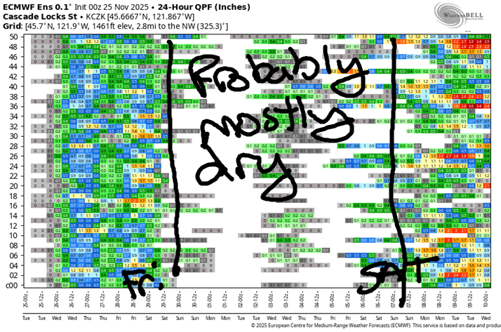
Beyond Friday, we have dry weather for the next week or so with the possible exception of a weak system Tuesday into Wednesday. Most members of the ensembles bring moisture back for the following weekend, but there’s a huge range in the possibilities, both precip quantity and temperature. So, no clear start to ski season in the next couple of weeks. My fingers remain crossed! Hope to see you out there soon!
Was that helpful? I knew it was! Guess what? All of this crucial work – from your personal wind and snow reports to the invaluable TATAS updates – is made possible by my relentless efforts. Maintaining this labor of love isn’t easy. Each daily forecast takes hours. Website hosting, weather model access, and back-end admin work takes time and money. That’s where you come in.
YOUR CONTRIBUTION MAKES A DIFFERENCE
- SUPPORT ACCURATE, HYPER-LOCAL WEATHER FORECASTING
- ENABLE ACCESS FOR ALL, EVEN THOSE WITH LESS MEANS
- SUPPORT A COOL HUMAN WHO WORKS HARD SO YOU CAN PLAY
Take a moment to click one of the buttons below. Donate $19.99 or more (how much does this forecast enhance your life?) and get the email in your inbox. Whether it’s a renewing subscription (auto-renew) or a one-time donation, every contribution makes a real difference. Help me keep this labor of love alive, so we can all continue playing, commuting, and living in the Gorge with peace of mind and the best weather forecasts possible. Thank you!


Hood River, Oregon 97031


GORGE WIND FORECAST
If you’re still seeing yesterday’s and it’s after 9am, try opening this in an incognito window
today’s gorge wind forecast
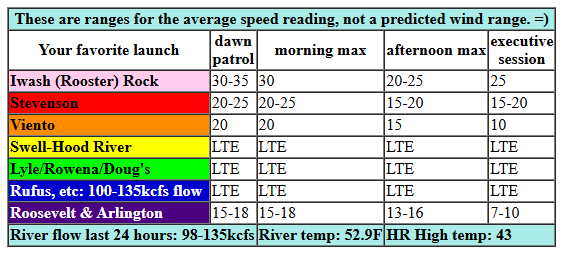
Hi friends! I don’t have much to offer you this week other than moderate easterlies and rain. While it won’t be great for wind sports, it will be a good time for doing the rainy run at Wyeth! Tuesday kicks off with easterlies at 30mph at Iwash (Rooster) Rock, 18mph at Stevenson, and 16mph at Viento. The wind holds for a few hours and then does the usual midday slide to 15-20mph. In a fun twist, models hint at a late bounce back to 25mph at Iwash. River flow over the last 24 hours was 98-135kcfs, river temp is 52.9F, and high temp forecast is 43F.
RIVER FLOW FOR SITES BETWEEN AVERY (EAST OF THE DALLES) AND RUFUS: CLICK HERE FOR JOHN DAY DAM FLOW.
RIVER FLOW FOR SITES BETWEEN STEVENSON AND DOUG’S BEACH (WEST OF THE DALLES): CLICK HERE FOR THE DALLES DAM FLOW

tomorrow’s gorge wind forecast
Wednesday brings easterlies at 15-20mph all day at both Stevenson and Iwash with 15mph at Viento. Add in drizzle in the morning and rain in the afternoon. High temp: 48F. Thursday looks a bit stronger, but it’ll also be raining hard most of the day. For the morning, we’ll have 30mph or so at both Stevenson and Iwash with 20mph at Viento. Afternoon wind falls to 10mph at Viento, 15-20mph at Stevenson, and 20-25mph at Iwash.
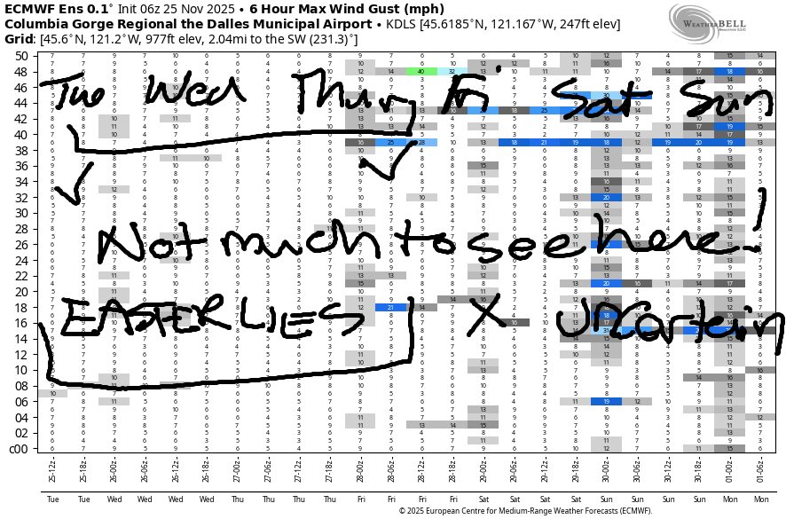
Jumping into the extended forecast, we see… not so much. Models had previously given us a low probability west wind day on Thursday or Friday, but they’re even less optimistic now. Beyond Friday, uncertainty is massive, and I’m not even going to try! We’ll see each other out there someday!
BARE BONES HOOD RIVER WEATHER FORECAST
Clouds this morning with rain this evening. Temps start in the upper 30s and rise to the low 40s. Light easterlies. No rainbows. Wednesday will be drizzly with a small break in the afternoon. Temps start in the upper 30s and rise to the upper 40s. Light easterlies. 17% chance of rainbows. Thursday will be dry to start then rainy into the evening. Temps start in the upper 30s and rise to the upper 40s. Light easterlies. 2% chance of rainbows.
TEMIRA’S AWESOME TRAVEL ADVISORY SERVICE
HYPERLOCAL WEATHER FORECAST FOR THE COLUMBIA GORGE
THE DALLES, HOOD RIVER, WHITE SALMON, TROUT LAKE, STEVENSON, CASCADE LOCKS, PARKDALE, ODELL, HUSUM, BZ, MILL A, WILLARD, GOLDENDALE, RUFUS, ARLINGTON, boardman
Good morning, neighbors! Good news: no snow or ice for Thanksgiving travel. Bad news: moderately heavy rain for Thanksgiving travel. Speaking of travel, some of you may have encountered an online rumor of ¡CE putting roadblocks on various highways for Thanksgiving. That simply isn’t true. First, CPB can’t do that unless they are within 100 miles of a border (the coast counts!), and next, no such activity has been seen by that agency. Source of my information: Oregon For All. Remember, before you get freaked out by information or share it, CALM yourself (a few deep breaths), CHECK the source, CONFIRM that it’s real!
Glenwood this morning
Moving on to something real: Glenwood was 29 degrees this morning with high overcast sky. That’s cold, but not as cold as ¡CE, who has not yet been spotted in the Gorge today. If you do see them, please call PIRC: 888-622-1510. Calling PIRC can warm your heart, a good thing in winter!
Today’s Gorge weather forecast
Looking around, it looks rather wintry as a warm front spreads a shield of clouds aloft. Drizzle starts up west of Wyeth early afternoon. This system gets hung up north of us, but eventually drops our way tonight. Expect heavy rain west of Hood River with moderate rain west of Rowena and east of Biggs. Between The Dalles and Biggs, a rain shadow makes for lighter rain tonight. Temps today only max out in the low 40s. Wind will be E 30mph near Iwash (pen¡s) Rock and 20mph near Stevenson with light east wind elsewhere.
Wednesday’s Gorge weather forecast
Wednesday starts drizzly west of The Dalles and east of Arlington. Everyone east of Cascade Locks gets a dry period before the next system. A “dry period” is what the menstrual cycle looks like when you’re my age. Far western Gorge on Wednesday: drizzly all day. Our next system pushes through quickly after 4pm and soaks all of us. Low temp; mid to upper 30s. High temp: upper 40s. Wind: easterlies at 15-20mph in the usual spots with light wind east of Viento. Snow level: 8000′.
Thanksgiving Gorge weather forecast
Thanksgiving morning starts off dry, but rain arrives by late morning. Expect heavy rain from 1pm through 10pm west of Hood River with moderate to heavy rain extending as far east as Rufus and perhaps the Tri-Cities. Even South Wasco gets hit with moderate rain from early afternoon on into the evening. Warn your visiting friends about the nastiness that is the western Gorge and encourage them to drive before the heavy rain hits, even if that means you get to / have to spend all day with them. Temps: upper 30s to start and upper 40s to finish. Snow level: 8500′ to start and falling, well….
Extended Gorge weather forecast
…models are all over the place on the snow level for Thursday afternoon into Friday. It is possible, but not certain that snowy conditions could materialize on the higher passes. Hopefully we’ll have a better understanding of this by tomorrow.
By Friday morning, the weather dries out. Dry weather sticks around through the weekend. You’ll recall that we had utter chaos in the models as they attempted to sort out the possibility of an incoming Arctic air mass. While it still looks like we’ll end up with cooler/drier air, extreme scenarios have fallen to the wayside. Naturally. Regression to the mean wins! Safe travels. -TATAS
HEY! DON’T STOP READING! Is this community-focused forecast helpful to you? It sure is! It takes me a couple hours a day to write. Please join your friends and neighbors in contributing to keep it going. Venmo: @thegorgeismygym PayPal: twomirrors@gmail.com USPS: Temira / PO Box 841 / Hood River, Oregon 97031 You can test out the forecast subscription for a few days for free by signing up below. Easy! Do it!
JONES BEACH, SAUVIE ISLAND, & COAST FORECAST
ON WINTER VACATION UNLESS DESPERATELY NEEDED.
