

MT HOOD SNOW FORECAST

Hey skiers and snowboarders! It’s time to break out the Meadows Performance Outerwear (plastic bags) for any mountain-related activities over the next week or so. While there is a short period of snow possible on Saturday afternoon, the vast bulk of the next week’s moisture will be too warm for snow at 5000′. As a matter of fact, 850mb temps (~5000′) aren’t forecast to drop below 0C until perhaps the 12th of December, and even that’s not certain – there’s a ton of uncertainty that far out. How much rain are we talking? 4-7” and potentially more depending on what happens next Tuesday/Wednesday!

Let’s look at the near-term future. It’s Tuesday, and a trace of snow is possible early today. The snow level will be around 3500′ this morning, 4000′ this afternoon, and 3000′ after midnight. Wind: NW 20 this morning, N 10 this afternoon, and light/variable overnight.
Wednesday starts off sunny and turns cloudy. Expect dry weather all day. The free air freezing level (FAF) will be 3000′ in the morning, 5500′ in the afternoon, and 6500′ after midnight. Wind: Light/variable early becoming NW 10-15 in the afternoon and N 15 overnight.
Thursday stats partly cloudy and quickly turns rainy. Snow level: 6500′ in the morning and 9000′ from the afternoon on. A trace of rain is forecast prior to 4pm. After that: 0.7”+ as an atmospheric river gets its fingers into Mt Hood. Wind: N 15 early, W 20 in the afternoon, W 30 in the evening, and WNW 45 after midnight. That stronger WNW wind will intensify rainfall thanks to orographic effects. Pouring rain (3” or so) continues on Friday with the snow level slowly falling from 9000′ to 6500′. Wind: WNW to NW 45 all day and W 35 after midnight.
The snow level drops as low as 4500′ on Saturday afternoon and gives us an inch or two of snow at 5000′. Warmer temps return on Sunday with another round of rain. A break Monday daytime leads to a period of higher uncertainty. It’s possible a much stronger atmospheric river will arrive in the late Monday to Wednesday time frame. Models have about a 50% chance of this happening. Through the middle of next week, the Euro ensemble gives us 4-7” total moisture. Whew… that’s a lot of rain. I’ll leave it here for now with no clear sign of the start of ski season. C’mon, Ma Nature!
Was that helpful? I knew it was! Guess what? All of this crucial work – from your personal wind and snow reports to the invaluable TATAS updates – is made possible by my relentless efforts. Maintaining this labor of love isn’t easy. Each daily forecast takes hours. Website hosting, weather model access, and back-end admin work takes time and money. That’s where you come in.
YOUR CONTRIBUTION MAKES A DIFFERENCE
- SUPPORT ACCURATE, HYPER-LOCAL WEATHER FORECASTING
- ENABLE ACCESS FOR ALL, EVEN THOSE WITH LESS MEANS
- SUPPORT A COOL HUMAN WHO WORKS HARD SO YOU CAN PLAY
Take a moment to click one of the buttons below. Donate $19.99 or more (how much does this forecast enhance your life?) and get the email in your inbox. Whether it’s a renewing subscription (auto-renew) or a one-time donation, every contribution makes a real difference. Help me keep this labor of love alive, so we can all continue playing, commuting, and living in the Gorge with peace of mind and the best weather forecasts possible. Thank you!


Hood River, Oregon 97031


GORGE WIND FORECAST
If you’re still seeing yesterday’s and it’s after 9am, try opening this in an incognito window

today’s gorge wind forecast
Hi friends! Active weather brings westerlies for the next few days. Thanks to a stronger system on Friday, there’s a decent chance of stronger westerlies. Another round of west wind is possible on Sunday if everything works out just right. My last forecast will probably be Thursday morning – I head out for retreat on Friday for five days, and the housesitter can’t fill in for me!
Tuesday started with westerlies at 17-20mph around 6am, but they were bouncing around as I wrote this forecast. We should see up-and-down 17-20mph from Viento to Rufus this morning. The eastern Gorge falls way off midday, and we’re left with 11-14 from Stevenson to The Dalles this afternoon. River flow over the last 24 hours was 90-164kcfs, river temp is 51.3F, and high temp forecast is 49F with decreasing clouds.
RIVER FLOW FOR SITES BETWEEN AVERY (EAST OF THE DALLES) AND RUFUS: CLICK HERE FOR JOHN DAY DAM FLOW.
RIVER FLOW FOR SITES BETWEEN STEVENSON AND DOUG’S BEACH (WEST OF THE DALLES): CLICK HERE FOR THE DALLES DAM FLOW

tomorrow’s gorge wind forecast
Wednesday starts with E 15mph at Stevenson and Iwash (Rooster) Rock. Easterlies quickly die off. After noon, westerlies pick up to 10-13mph or so from Stevenson to the Hatch with lighter wind to the east. High temp: 44F with increasing clouds.
extended Gorge wind forecast
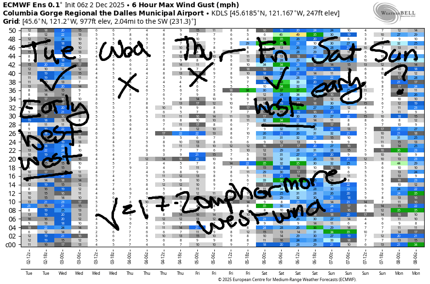
Thursday sees a relatively strong weather system approach. With this pattern we’ll often see westerlies west of Hood River (sometimes at the Hatch, sometimes just Viento) and east of The Dalles. The day looks to start with 11-14mph, and it looks to finish with 18-22mph, confined to the regions mentioned above.
A stronger system swings through on Friday. This one’s accompanied by very strong W/NW wind aloft. This often (but not always) results in strong wind at Viento and from Avery-Rufus. As of this morning, the forecast calls for gusty and very rainy 20-25 west of Mosier with 25mph, give or take (ensembles are on the low end) from Avery to Rufus. Fingers crossed for all of you – I’ll be driving to retreat through the downpour. Westerlies linger Friday night and die off on Saturday. About 40% of the ensembles predict a round of moderate to moderately strong west wind Sunday. Wishing you all lots of wind while I’m on retreat! Oh, one more thing: this Saturday is the Big Winds Locals’ Appreciation Day sale. This is a good one. Doors open at 9am.
BARE BONES HOOD RIVER WEATHER FORECAST
Clouds this morning with a little drizzle possible. Partly cloudy later. Temps start in the low 40s and rise to the upper 40s. Light westerlies. 28% chance of rainbows. Wednesday will be partly Nothing then mostly cloudy. Temps start in the low-mid 30s and rise to the mid 40s. Light easterlies then light westerlies. No rainbows. Thursday starts dry but quickly turns drizzly. Rain increases into the afternoon. Temps start in the mi d30s and rise to the upper 40s. Light to moderate westerlies 73% chance of rainbows.
TEMIRA’S AWESOME TRAVEL ADVISORY SERVICE
HYPERLOCAL WEATHER FORECAST FOR THE COLUMBIA GORGE
THE DALLES, HOOD RIVER, WHITE SALMON, TROUT LAKE, STEVENSON, CASCADE LOCKS, PARKDALE, ODELL, HUSUM, BZ, MILL A, WILLARD, GOLDENDALE, RUFUS, ARLINGTON, boardman

Good morning, neighbors! Two beautiful fall days are on tap, and then we plummet into a period of profound precipitation (for some, not all). Our biggest weather concerns over the next week will be potential freezing fog on Wednesday morning, a TERRIBLE drive through the western Gorge thanks to torrential downpour on Friday, and the potential for another soaking in the (next week) Tuesday-Wednesday time frame. BUT NOT TODAY! Today looks spectacular!
Glenwood this morning and today’s Gorge weather forecast
After some morning drizzle west of Mosier and east of Arlington (where it could be freezing drizzle!), we’ll have a partly cloudy (west) and sunny (east) day. Heck yeah! Beautiful day to pull the dahlia bulbs, methinks. Temps rise to 50F or so today west of Biggs and stay in the low 40s to the east. We’ll have west wind at 15-20mph in the morning between Viento and Arlington with 10-15mph in the afternoon. SUNSHINE!!!!!!!
Almost forgot Glenwood: 26 degrees there this morning!
Wednesday’s Gorge weather forecast
Thanks to clear sky, temps tumble into Wednesday morning. Expect mid to upper 20s away from the Nch’i Wana and low to mid 30s near it. Nothing settles in along the river early, but it dissipates in the face of incoming mid and high clouds in the afternoon. In the Nothing zone, freezing fog and slick roads are possible. Wind: E 15mph in the usual spots in the morning, calm midday, W 10-15mph west of Mosier in the afternoon with light wind to the east. Make the most of this dry day, because, for many of us, rain is coming. Thanks to W/NW flow, however, areas between Rowena and the Arlington Triangle will spend much of this wet period dry. These things happen.
Thursday-Friday Gorge weather forecast
Starting around 10am on Thursday, a weather system slides in from the NNW. Rain intensity increases overnight with the heaviest rain east of Biggs. Thursday temps: mid 30s in the morning and 50ish in the afternoon with the snow level rising to (sad) 9000′. Much, much, much wetter weather is forecast Friday west of Rowena and from the Tri-Cities eastward. In the middle of those two zones: dry thanks to rain shadowing. Those of us driving through the western Gorge on Friday will face very heavy rain from 1am until 4pm or so (timing subject to change). Hydroplaning chances: nearly 100%. Friday’s high temps – this is how you know we’re in Pineapple Express territory – will be 54-57F. Same on Saturday.
Extended Gorge weather forecast
Additional light to moderate rainfall is forecast over the weekend. For now, Monday looks dry. Models then like the idea of another, stronger, atmospheric river in the Tuesday-Wednesday time frame. They’re about 50% in on the very heavy moisture, so we could sneak by dry. Hard to say at this point. I’ll be gone Friday through next Wednesday. The housesitter has declined to forecast for you, so you’re on your own! At least we’re not expecting any snow or freezing rain! Safe travels. -TATAS
HEY! DON’T STOP READING! Is this community-focused forecast helpful to you? It sure is! It takes me a couple hours a day to write. Please join your friends and neighbors in contributing to keep it going. Venmo: @thegorgeismygym PayPal: twomirrors@gmail.com USPS: Temira / PO Box 841 / Hood River, Oregon 97031 You can test out the forecast subscription for a few days for free by signing up below. Easy! Do it!
JONES BEACH, SAUVIE ISLAND, & COAST FORECAST
ON WINTER VACATION UNLESS DESPERATELY NEEDED.
