MT. HOOD SNOW FORECAST

Hey skiers and snowboarders! Hopefully some of y’all made it up to the mountain yesterday. I was skating at Teacup, and it was the absolute best day of the season so far. Most of the groom was hardpack, and there were a few little areas of packed powder and granular mixed in. You should find the same on the alpine side today with the addition of scoured areas up high. But wait… with temps above freezing, a few hours of sun on those scoured areas should give us a shot at corn snow. And so it continues for most of the next 10 days – the weather looks quite dry (with the exception of a few sprinkles/flurries Thursday) all the way through the weekend of the 25th. And maybe beyond.
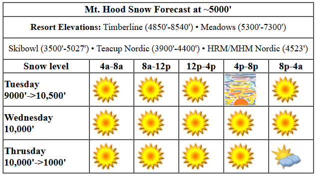
Tuesday’s going to be sunny to start with a few high clouds later. The free air freezing level (FAF) will be 9000′ this morning, and it’ll rise to 10,000′ this afternoon. Temps start in the mid 30s and rise to the low 40s at 5000′. Wind: N 10 this morning, NW 10-15 this afternoon, and light/variable overnight. Blue sky and sunshine is the call for Wednesday with temps maxing out near 50 degrees as the FAF holds at 10,000′. Wind will be light and variable all day. It turns westerly at 15mph overnight.
Liking this forecast?
A weak system on Thursday does little more than amp up the wind a bit; models suggest moisture will not be deep enough to affect areas above 5000′. I suppose a little drizzle or a few flurries are possible in the lowest areas – Skibowl comes to mind – but it’s unlikely. Expect sun up high. The FAF falls from 10,000′ in the morning to 8000′ in the afternoon and down below 1500′ after midnight. Wind: W 15 in the morning, W 25-30 in the afternoon, and NE 10 overnight.
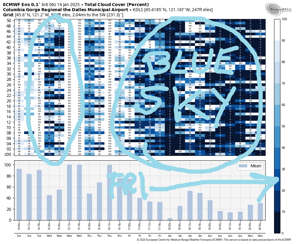
We’re back to dry, mostly sunny weather starting Friday. One big change: sub-freezing temps will accompany the sunshine through at least Saturday and possibly into Sunday. Next chance of precipitation of any sort doesn’t arrive until the following weekend, and even then, models are not all-in on the dry spell ending. Better stock up on sunscreen! Have an awesome day on the slopes.
Was that helpful? I knew it was! Guess what? All of this crucial work – from your personal wind and snow reports to the invaluable TATAS updates – is made possible by my relentless efforts. Maintaining this labor of love isn’t easy. Each daily forecast takes hours. Website hosting, weather model access, and back-end admin work takes time and money. That’s where you come in.
YOUR CONTRIBUTION MAKES A DIFFERENCE
- SUPPORT ACCURATE, HYPER-LOCAL WEATHER FORECASTING
- ENABLE ACCESS FOR ALL, EVEN THOSE WITH LESS MEANS
- SUPPORT A COOL HUMAN WHO WORKS HARD SO YOU CAN PLAY
Take a moment to click one of the buttons below. Donate $19.99 or more (how much does this forecast enhance your life?) and get the email in your inbox. Whether it’s a renewing subscription (auto-renew) or a one-time donation, every contribution makes a real difference. Help me keep this labor of love alive, so we can all continue playing, commuting, and living in the Gorge with peace of mind and the best weather forecasts possible. Thank you!


Hood River, Oregon 97031


GORGE WIND FORECAST

Hi friends! Lots of easterlies in your future, but there’s also a west wind day in the cards. Let’s take a look! Tuesday kicks off with very light east gradients and easterlies under 15mph. Stevenson should rise to 15mph this afternoon, but everywhere else will be 10mph or less. River flow over the last 24 hours was 101-171kcfs, river temp is 42.98F, and high temp forecast is 43F with sun in the east wind zone.
Wednesday starts sub-freezing with a round of strong east wind. We’ll see 25-30mph to start at Stevenson and 40-50mph to start at Iwash (Rooster) Rock. Stevenson bumps up 5mph midday before dropping to 25mph in the afternoon. Iwash fades to 35-40mph in the afternoon. High temp will be 42F with sunshine in the windy zones. Thursday starts with easterlies at 15-25mph in the usual spots, but they shut off quickly. Models disagree on the timing of incoming westerlies; for now, let’s call it 24-27 from late morning on through the afternoon between Viento and Hood River or perhaps Stevenson and Mosier. High temp: 49F (and dropping into the afternoon) with clouds in the west and sun out east. Easterlies return on Friday and build into early next week as high pressure and colder air settles in on the east side of the Cascades. Enjoy!
BARE BONES HOOD RIVER FORECAST
Nothing sticks around for Tuesday. Temps start in the low-mid 30s and rise to the upper 30s. Very light easterlies. No rainbows. Wednesday will be Nothing then less Nothing. Temps start in the upper 20s and rise to the upper 30s. Easterlies. No rainbows. Thursday starts with Nothing, then turns breezy and partly to mostly cloudy. A few sprinkles could fall. Temps start in the upper 20s and rise to the upper 40s. Light easterlies early. Moderately strong westerlies later. 9% chance of rainbows.
TEMIRA’S AWESOME TRAVEL ADVISORY SERVICE (DETAILED GORGE WEATHER)

Good morning, neighbors! Not much to see here – lots of Nothing down low, lots of sun aloft, and plenty of wind in the usual spots. Next chance of measurable precip is … a long time from now.
The most exciting thing coming up in the weather: colder-than-recently temps forecast for Friday into the weekend.
TODAY
Tuesday, today, brings Nothing down low and sun up high. Add in a few high clouds in the afternoon for a potentially pretty sunset. Temps max out in the low 40s where its sunny and mid to upper 30s below the Nothing. Even the wind is uninteresting today – 15mph near Iwash and Stevenson, max.
WEDNESDAY
Clear sky aloft and Nothing down low sets us up for a chilly start to Wednesday. Whatever temp you started with today will be the temp you start with on Wednesday. Models hint at the sky clearing at all elevations by afternoon. FINGERS CROSSED. Easterlies will be 40-50mph near Iwash and 25-35mph near Stevenson. Thursday starts just like Tuesday and Wednesday, but it ends differently.
THURSDAY
A cold front swings through midday or in the afternoon. A little drizzle is possible west of Hood River. When this system swings through, it scours out the Nothing and fires up the westerlies: 20-30mph from Stevenson to Mosier with 15-20mph east to Arlington. High temps rise into the mid to upper 40s at the start of this system and drop as it moves through. Overnight: clear sky aloft, Nothing below.
AND BEYOND…
That system drags in cooler air, cool enough for sub-freezing nights, but not cold enough for anyone except folks in Glenwood to have any sort of “interesting” temps. Cooler air then sticks around through the weekend. If it gets cold enough and dry enough, we’ll have sun! Guess what we won’t have? Precipitation. That’s waiting until 10 days out, at the earliest, but hopefully not while I’m gone on retreat. Safe travels. -TATAS
HEY! DON’T STOP READING! Is this community-focused forecast helpful to you? It sure it! It takes me a couple hours a day to write. Please jump in a contribute to keep it going. Venmo: @thegorgeismygym PayPal: twomirrors@gmail.com USPS: Temira / PO Box 841 / Hood River, Oregon 97031 You can test out the forecast subscription for a few days for free by clicking this link: https://subscribepage.io/YhevGc


