

GORGE WIND FORECAST
today’s gorge wind forecast
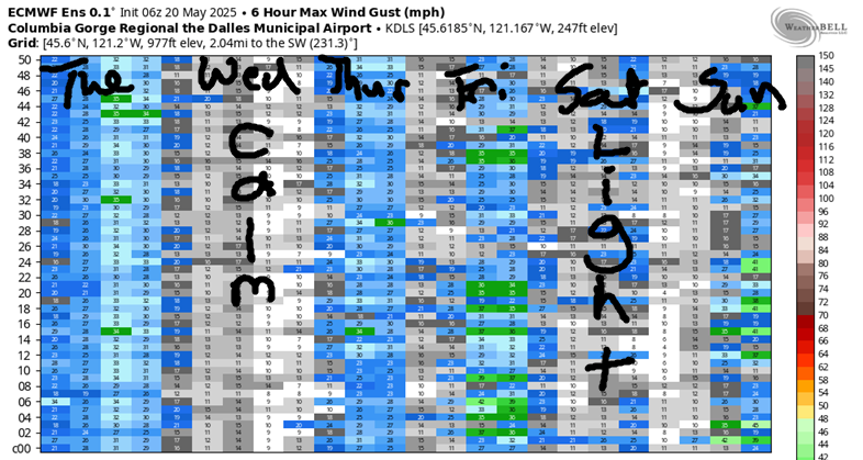
Hi friends! Rather normal spring weather continues, and that leaves us with moderate strength westerlies in the Gorge wind forecast on and off over the next week or so. Ensembles peg Wednesday as a rest day with nearly calm wind nearly all day. Saturday also looks quite light. Beyond Saturday, there’s quite a bit of uncertainty in the models, but at least some hint of wind. Strongest day of the bunch is likely Friday. Let’s dive in to the details, shall we?
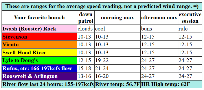
It’s Tuesday, and it’s starting off with the site I normally use for pressures not reporting since yesterday… Backup pressure source says: 30.22/30.17/30.13 for 0.05/0.04. As a low moves into BC today and a front swings through the Gorge, offshore high pressure will start to lend a hand. Early wind was generally 5-15mph in the Gorge with 12-15 near Rufus. By late morning, we’ll have 10-13mph from Stevenson to Avery (with showers as far east as Hood River) and 21-24 from Avery to Arlington. Westerlies build this afternoon to 24-27 or a touch more between Avery and Arlington with gusty 17-21 from Mosier to Doug’s and 12-15 from Stevenson to Hood River. River flow over the last 24 hours was 155-196kcfs (166-197kcfs at Rufus), river temp is 56.7F, and high temp forecast is 62F for Hood River and 64F for Arlington. Partly cloudy sky lingers all the way into the eastern Gorge into the evening.

tomorrow’s gorge wind forecast
Wednesday bring a brief ridge of high pressure to the Gorge. This shuts down the wind for most of the day. If you’ve been wanting waterskiing or road biking conditions, you’ll have them. Late in the day, probably after 5pm, westerlies pick up to 11-14 from Stevenson to Swell. They’ll stay under 10mph to the east, and will stay calm in many places. High temp: 70F for Hood River with partly cloudy sky that becomes clear, then partly high overcast.
extended Gorge wind forecast
A weak system swings through on Thursday, and weak high pressure builds offshore. There won’t be much support for wind, but there might be just enough for some of you. In the morning, we’ll have calm wind or at least less than 10mph. Westerlies pick up to 7-10 from Stevenson to Doug’s and linger in that zone. Between Avery and Boardman, westerlies slowly build to 17-21mph and hold into the evening. High temp: 68F with clouds and drizzle in the morning with mostly clear sky in the afternoon.
Model agreement is lower than usual starting Friday and continuing through the Memorial Day weekend. Friday looks windy enough: mid to upper 20s in the eastern Gorge. Saturday’s probably going to be too light, but there’s a chance it’ll bring just enough wind. Agreement really falls apart on Sunday, which will be the warmest day of the bunch, as models struggle with timing and placement of colder offshore air pushing inland. There’s some indication (60-70% of the ensembles) of a stronger day on Monday followed by a decent day on Tuesday, but let’s get closer and get some more agreement before penciling anything in, shall we? Have an awesome day today!
Was that helpful? I knew it was! Guess what? All of this crucial work – from your personal wind and snow reports to the invaluable TATAS updates – is made possible by my relentless efforts. Maintaining this labor of love isn’t easy. Each daily forecast takes hours. Website hosting, weather model access, and back-end admin work takes time and money. That’s where you come in.
YOUR CONTRIBUTION MAKES A DIFFERENCE
- SUPPORT ACCURATE, HYPER-LOCAL WEATHER FORECASTING
- ENABLE ACCESS FOR ALL, EVEN THOSE WITH LESS MEANS
- SUPPORT A COOL HUMAN WHO WORKS HARD SO YOU CAN PLAY
Take a moment to click one of the buttons below. Donate $19.99 or more (how much does this forecast enhance your life?) and get the email in your inbox. Whether it’s a renewing subscription (auto-renew) or a one-time donation, every contribution makes a real difference. Help me keep this labor of love alive, so we can all continue playing, commuting, and living in the Gorge with peace of mind and the best weather forecasts possible. Thank you!


Hood River, Oregon 97031


JONES BEACH, SAUVIE ISLAND, & COAST FORECAST
Wind northerly unless otherwise indicated. For coast, it’s North/Central/South with the “central” at approximately Florence. Swell forecast from NWS for central coast. Jones: westerly unless otherwise stated. Sauvie Island: northerly unless otherwise stated. Tuesday: W10/LTV/N25, W swell 2′ at 13 seconds. Wednesday: 15-20/20-25/25, W 7′ @ 11 and SW 2′ @ 18. Thursday: WNW15/WNW15/N15-20, SW 2′ @ 18. Jones Tuesday: LTV. Wednesday: 12-15. Thursday: 13-16. Sauvie Island Tuesday: LTV. Wednesday: 11-14. Thursday: LTV.
BARE BONES HOOD RIVER WEATHER FORECAST
Clouds today with rain from mid-morning on. Temps start in the low 40s and rise to the low 50s. Calm wind. 11% chance of rainbows. Thursday will be showery all day. Temps start in the upper 30s and rise to the upper 40s. Moderate westerlies. 99.99% chance of rainbows. Friday will be High overcast and dry in the morning with rain in the afternoon. Temps start in the low-mid 30s and rise to the mid 40s. Light easterlies. 4% chance of rainbows.
TEMIRA’S AWESOME TRAVEL ADVISORY SERVICE
HYPERLOCAL WEATHER FORECAST FOR THE COLUMBIA GORGE
THE DALLES, HOOD RIVER, WHITE SALMON, TROUT LAKE, STEVENSON, CASCADE LOCKS, PARKDALE, ODELL, HUSUM, BZ, MILL A, WILLARD, GOLDENDALE, RUFUS, ARLINGTON, boardman

Good morning, neighbors! It’s raining at my place in Hood River this morning, but I haven’t seen a rainbow yet. I know they’re out there. We’re going to be graced by the graceful multi-colored arch today! We’ll also have plenty of sun this afternoon to prepare us for sunnier, calmer, warmer day on Wednesday. After that: back into rather typical spring weather (rain Thursday, hot Sunday, windy most days except Wednesday and Saturday) for the long haul. Until it’s summer. Then we won’t have typical spring weather any longer, unless June-uary and July-uary make a showing.
today’s gorge weather forecast
Today has a bit of June-uary feel with temps running about 8 degrees below normal. Today, by the way, is Wednesday. Glenwood started the day at 42 degrees, which we all know is the answer to life, the universe, and everything. Except that it’s not really. The answer is truly understanding what you are, which is that you are an incredibly vibrant and deeply interconnected being underneath all the crap that’s accumulated from a lifetime of human difficulties. You are also a human being who carries, underneath all that, a wellspring of joy, kindness, and delight that is your birthright and well within your capacity to access at any moment in time.
But we were talking about weather, weren’t we? Not awakening. But I’m happy to talk awakening any time! Intermittent drizzle and rainbows are possible as far east as Hood River this morning and near Corbett this afternoon. Temps in the Gorge rise to the low 60s, and the sky turns partly cloudy. Westerlies build to 10-15mph west of Lyle and 25mph from Lyle to Boardman this afternoon. I’m happy it’s going to be nice and cool – the hot flashes have been fierce (like my commitment to kindness) this morning.
wednesday’s gorge weather forecast
On to Wednesday. It starts partly cloudy, calm, and around 40 degrees as a brief ridge of high pressure settles in for a short stay. 850mb (5000′) temps will range from 0C to -2C, which puts Glenwood at risk for sub-freezing temps. Parkdale, Trout Lake, Centerville, and the cold areas on the east side of The Dalles are likely to drop into the 30s, but frost is unlikely. After that cool start, sunbeams seize the day and take high temps to 70 degrees under sky that’s clear midday and has some high clouds in the evening. Ah, evening high clouds – that’s what makes a stellar sunset. I see that in your future and mine. Wind: calm in the morning, W 10mph west of Mosier, and only west of Mosier, in the afternoon.
thursday’s gorge weather forecast
In a fun twist, Thursday morning brings another round of drizzle. A trace to 0.2” is forecast. It’s possible a moderate to heavy band of rain will set up over us early in the morning, which could give us a nice soaking. After 11am, the rain shuts off and leaves us with clearing sky. Temps start near 50 and rise to the upper 60s. We’ll have light wind early (which doesn’t help you spray, because it’ll be raining) and building westerlies in the afternoon. They max out at 10mph west of Avery and 20mph between Avery and Boardman.
extended gorge weather forecast
A warming trend begins on Friday and ends on Sunday when models have us at 80-85 degrees all through the Gorge. Models then insist on a 10 degree high temp drop into Memorial Day, which is likely to set up 1) west wind and 2) great barbecuing weather. Looking at next week, it starts cool and slowly warms, although models have about 15 degrees of spread in the possible high temps for the end of the week. It’s worth noting that there’s really no sign (at this point, anyway), of an early season heat wave. Yay. Valuable Advice for Gardeners Inhabiting Neighboring Areas: given this forecast, I need to get my ass in gear and build a mini greenhouse for my giant watermelon and for my second giant pumpkin. Also, thanks to y’all nagging me, I got carrots, beets, spinach, cilantro, parsley, and a second round of random greens planted yesterday. I appreciate the nudging and will make sure to let you know how all that fiber makes my life better (on the throne with my squatty potty below my feet) once those crops are mature. There’s nothing more supportive of conditional happiness than a good morning poop. Happy gardening. Safe travels. -TATAS
HEY! DON’T STOP READING! Is this community-focused forecast helpful to you? It sure is! It takes me a couple hours a day to write. Please join your friends and neighbors in contributing to keep it going. Venmo: @thegorgeismygym PayPal: twomirrors@gmail.com USPS: Temira / PO Box 841 / Hood River, Oregon 97031 You can test out the forecast subscription for a few days for free by signing up below. Easy! Do it!
