

GORGE WIND FORECAST
today’s gorge wind forecast (Tuesday)
Hi friends! Lots of fun on tap: ensembles have seven out of the next eight days with solid westerlies. Strongest days as of the 00Z Euro run look like today, tomorrow, and next Saturday and Sunday (potential nuker) with 50/50 chances for strong wind next Monday. Speaking of strong wind… it’s already quite windy out there this morning, and yesterday’s over-performing afternoon (thank you upper-level NW flow) is a great sign for today. Have to pick between today and tomorrow? Between the Euro and GFS, there’s no consensus on which looks better, but today has a better chance for solid wind near Hood River if that helps at all.
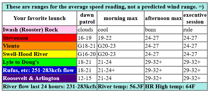
Let’s look at today, Tuesday. 5am gradients were 30.00/29.90/29.85, and westerlies at 6am were already 20+ at Swell, 20 near Rowena, 30 at the Maryhill Bridge, and 10-15 far east and Stevenson. Low clouds are past Hood River at the time of this forecast, but they’ll burn back. This sets us up for 24-27 from Stevenson to Mosier by late morning or early afternoon with 28-31 from Lyle to Arlington and 23-26 east of Arlington to Boardman. Mid afternoon sees westerlies rise to 30-33 from Lyle to Arlington with 27-30 at Threemile and 23-26 at Boardman. The west side holds at 24.27ish. With upper flow at NW 30mph and strong offshore high pressure, this seems like a slam dunk sort of day. River flow over the last 24 hours was 231-283kcfs (251-283kcfs at Rufus), river temp is 56.3F, and high temp forecast is 64F for Hood River and 66F for Arlington.

tomorrow’s gorge wind forecast
Looking at tomorrow, we see another windy day. Offshore high pressure keeps on rocking, upper flow turns to W 30mph, and a cap settles in and really holds the wind down on the river. Models are back and forth on which day (Tuesday or Wednesday) will be windiest. Given the fact that Wednesday’s low clouds will push at least as far as The Dalles, I can confidently say that Swell will be less windy. Call the Stevenson to Doug’s stretch 17-20 on Wednesday, at least until clouds burn off mid afternoon. Out east: we start with 23-26 from Celilo to Boardman and finish with 29-32 from Avery to Boardman. High temp: 63F for Hood River and 65F for Arlington.
extended Gorge wind forecast
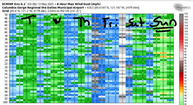
Somewhat lesser wind is forecast on Thursday, but it’ll still be plenty. We start with 18-21 from Stevenson to Boardman. We finish with gusty 20-24 from Stevenson to Hood River and 26-29 from Mosier to Arlington. Friday looks like the lightest day of the week. Models max out at 17-20 (high end) or 11-14 (low end). We’re back to strong westerlies for all of the Victoria Day weekend. Models are very, very excited about Sunday’s potential for a nuking westerly day. I’m keeping a very close eye on that one. There’s a good chance there will be a friendly downwind SUP foil race happening that day somewhere out east. Ensembles keep the westerlies going into Monday and Tuesday before uncertainty takes a firmer grasp on the picture. Whew. That’s a lot of wind. I’m tired just writing about it. See you on the Nch’i Wana!
Was that helpful? I knew it was! Guess what? All of this crucial work – from your personal wind and snow reports to the invaluable TATAS updates – is made possible by my relentless efforts. Maintaining this labor of love isn’t easy. Each daily forecast takes hours. Website hosting, weather model access, and back-end admin work takes time and money. That’s where you come in.
YOUR CONTRIBUTION MAKES A DIFFERENCE
- SUPPORT ACCURATE, HYPER-LOCAL WEATHER FORECASTING
- ENABLE ACCESS FOR ALL, EVEN THOSE WITH LESS MEANS
- SUPPORT A COOL HUMAN WHO WORKS HARD SO YOU CAN PLAY
Take a moment to click one of the buttons below. Donate $19.99 or more (how much does this forecast enhance your life?) and get the email in your inbox. Whether it’s a renewing subscription (auto-renew) or a one-time donation, every contribution makes a real difference. Help me keep this labor of love alive, so we can all continue playing, commuting, and living in the Gorge with peace of mind and the best weather forecasts possible. Thank you!


Hood River, Oregon 97031


JONES BEACH, SAUVIE ISLAND, & COAST FORECAST
Wind northerly unless otherwise indicated. For coast, it’s North/Central/South with the “central” at approximately Florence. Swell forecast from NWS for central coast. Jones: westerly unless otherwise stated. Sauvie Island: northerly unless otherwise stated. Tuesday: NW10/NW5-10/N15, W swell 9′ at 10 seconds. Wednesday: NW10/N10/N20-25, W 6′ @ 10. Thursday: LTW/LTW/N25-30, W 4′ @ 11. Jones Tuesday: 14-17. Wednesday: 7-10. Thursday: LTW. Sauvie Island Tuesday: NW 10-13. Wednesday: NW 10-13. Thursday: N 10-13.
BARE BONES HOOD RIVER WEATHER FORECAST
Mostly cloudy this morning and partly cloudy later. Temps start in the low 50s and rise to the mid 60s. Strong westerlies. No rainbows. Wednesday will be cloudy with intermittent drizzle/sprinkles until early afternoon. Temps start in the mid 40s and rise to the low 60s. Moderate westerlies. 29% chance of rainbows. Thursday will be high overcast to start and plain old cloudy in the afternoon. Temps start in the low 40s and rise to the low 60s. Moderately strong westerlies. 4% chance of rainbows.
TEMIRA’S AWESOME TRAVEL ADVISORY SERVICE – TUESDAY 5/13
HYPERLOCAL WEATHER FORECAST FOR THE COLUMBIA GORGE
THE DALLES, HOOD RIVER, WHITE SALMON, TROUT LAKE, STEVENSON, CASCADE LOCKS, PARKDALE, ODELL, HUSUM, BZ, MILL A, WILLARD, GOLDENDALE, RUFUS, ARLINGTON, boardman

Good morning, neighbors! It’s Tuesday. The Gorge might not be giving us our usual spring rain, but it’s about to crank up the usual spring westerlies. We have a very windy upcoming 8 days (there are eight days in a week, you know). Need a light wind day? The lightest of the bunch will be Friday, but even it will not be calm. While the wind won’t be calm, you should remain calm if you can. Equanimity is good. Indifference: not good – it takes the connection and care out of the ups and downs of life.
GLENWOOD
Speaking of ups and downs, let’s look at Glenwood’s thermometer. It’s reading 30 degrees this morning as Glenwood shows us all up by producing yet another sub-freezing morning. Good job, Glenwood!
today’s gorge weather forecast
On to the rest of us: we have a partly cloudy and generally 50 degree start today thanks to onshore flow and offshore high pressure. Hopefully this forecast is on point so I don’t lead you off the deep end. Temps rise to the mid 60s today (that falls in the TATAS perfect zone), and westerlies rise to the “Happy Wind Johnny” zone. Call it 25mph west of Lyle and 30-mph east of Lyle out to the Arlington Triangle. This zone contains at least 3 Indian food carts, which is the best measure of a zone’s awesomeness. We’ll give it five stars for food potential. This morning’s clouds dissipate this afternoon and leave all of us under partly cloudy to mostly clear sky.
wednesday’s gorge weather forecast
More intrusive – all the way to The Dalles – low clouds on Wednesday morning break up in the afternoon like a glass window tossed from a high location (please check below you before attempting this). Morning temps will be in the mid 40s. With 850mb temps forecast to be around -1C, Glenwood is likely to be sub-freezing yet again. Afternoon highs only make it to the low/mid 60s. Westerlies rise to 20mph west of Mosier and 30mph from Mosier eastward. Once again, this results in the Wind Johnnies scattering like ants in a disrupted hill. You can’t eliminate them – they have no queen running their show, just like you have no actual self running your show. It’s an illusion, folks! Free yourself from it!
thursday’s gorge weather forecast
Looking to Thursday, we see a high cloud morning and a more-cloud afternoon. 850mb temps will be -2C or maybe even -3C, which puts us at risk of a light frost in a few areas if the high clouds are translucent enough for radiational cooling to take hold. We’ll dig into this possibility more deeply tomorrow. By Thursday afternoon, we’ll have low 60s and yet another round of strong westerlies: 20mph west of Mosier and 25-30mph between Mosier and the Arlington Triangle.
“Fuck yeah Friday”‘s gorge weather forecast
We then move on to Friday, when the wind will be lighter, temps will be about 5 degrees warmer, and all folks on a standard workweek will be celebrating the coming of Friday. We call it “Fuck Yeah Friday (FYF)” Folks who appreciate tourists will be celebrating the Coming of the Canucks, as our friends north of the border eye what promises to be a very windy Victoria Day weekend. Hopefully they bring Cheezies and Coffee Crisp candy bars. High temps continue to be rather Canadian: other than a slight chance on Friday, we won’t see 70 degrees again until May 25th or so. Probably. Those longer-range models have lots of uncertainty. Despite that, I can say with confidence that we won’t be setting any record high temps any time soon – there’s no sign at all of a wickedly nasty heat wave in the near future. Let’s thank the nearest star, Sol, for that. Speaking of, I’m going to go thank it for rising and not going supernova. Have a lovely day, all of you. Be kind to each other. Safe travels. -TATAS
HEY! DON’T STOP READING! Is this community-focused forecast helpful to you? It sure is! It takes me a couple hours a day to write. Please join your friends and neighbors in contributing to keep it going. Venmo: @thegorgeismygym PayPal: twomirrors@gmail.com USPS: Temira / PO Box 841 / Hood River, Oregon 97031 You can test out the forecast subscription for a few days for free by signing up below. Easy! Do it!

2 responses to “Tuesday Gorge wind forecast: windy. Lots of wind and cool weather for the next 10 days.”
Your forecasts are the most spot on for our area,thank you very much.
Love you Temira!