

GORGE WIND FORECAST
If you’re still seeing yesterday’s and it’s after 9am, try opening this in an incognito window
today’s gorge wind forecast
Hi friends! I woke up at a reasonable time today, so here we are with a forecast. Next best chance for west wind is tomorrow (Wednesday) mid-afternoon. Thursday looks calm, and Friday looks like less than 10mph. A system could drive strong westerlies sometime in the Saturday-Sunday period, but the current timing of that wind is overnight Saturday. Worth noting: I had a report that Post Canyon dirt was perfect yesterday, and there’s some potential for enough snow for earn-your-turns Sunday into Monday…. One last thing: HRATS has a work party on Sunday. Meet at Family Man at 9am. Get it on your calendar now so you don’t forget!
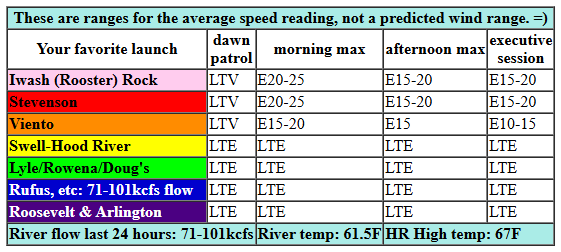
Looking at today on the river… Conditions started out light/variable with very light onshore gradients. Wind direction turns easterly this morning. Iwash maxes out around 20mph late morning, and Stevenson peaks at 20-25mph. Afternoon wind falls to 15-20mph at both spots. Viento will probably hover around 15mph, which is pretty marginal for Viento. River flow over the last 24 hours was 71-101kcfs, river temp is 61.5F, and high temp forecast is 67F.
RIVER FLOW FOR SITES BETWEEN AVERY (EAST OF THE DALLES) AND RUFUS: CLICK HERE FOR JOHN DAY DAM FLOW.
RIVER FLOW FOR SITES BETWEEN STEVENSON AND DOUG’S BEACH (WEST OF THE DALLES): CLICK HERE FOR THE DALLES DAM FLOW

tomorrow’s gorge wind forecast
Wednesday brings a weak weather system through. That system will be just enough to turn the wind onshore in the afternoon. Early wind will be easterly at 20-25mph at Stevenson and Iwash (Rooster) Rock with 15-20mph at Viento. That’ll only last for a couple hours – by 11am, the wind turns calm and then quickly switches to light westerly. After 2pm, we should see gusty 15-18mph from Stevenson to Mosier with gusty 20-23mph from Lyle to Rufus. After 5pm, the wind drops below 10mph west of The Dalles and spreads east to Arlington at 20mph-ish. High temp: 66F for Hood River.
extended Gorge wind forecast
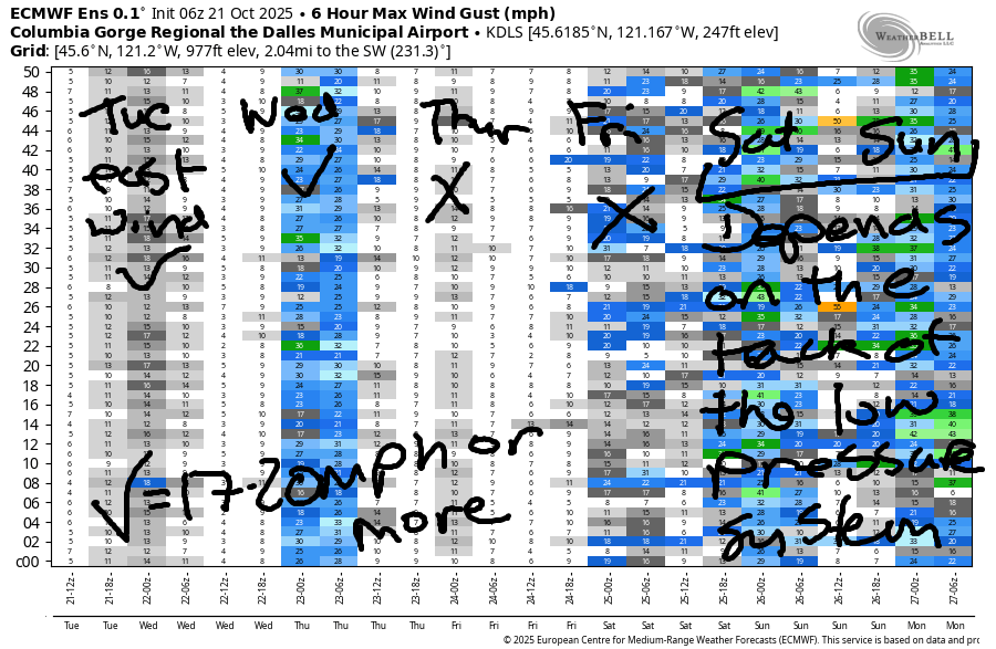
Another system swings through on Thursday but doesn’t do much. Wind will be calm or very light westerly all day long. Something different this way comes on Friday: lots of rain and (probably) very little wind. A compact, deep low approaches the coast on Saturday. This likely results in (very wet) easterlies in the morning. Models are all over the place on when/where that low will make landfall and when/if it will cross the Cascades close enough to us for a period of strong westerlies. Wind or no wind, it’s likely to be very wet this weekend with temps below 60F. We’ll keep a close eye on the evolution of the forecast around this low – some of the biggest days happen when a low crosses the Cascades and high pressure builds behind it. That’s all for now. See you on the Nch’i Wana!
Was that helpful? I knew it was! Guess what? All of this crucial work – from your personal wind and snow reports to the invaluable TATAS updates – is made possible by my relentless efforts. Maintaining this labor of love isn’t easy. Each daily forecast takes hours. Website hosting, weather model access, and back-end admin work takes time and money. That’s where you come in.
YOUR CONTRIBUTION MAKES A DIFFERENCE
- SUPPORT ACCURATE, HYPER-LOCAL WEATHER FORECASTING
- ENABLE ACCESS FOR ALL, EVEN THOSE WITH LESS MEANS
- SUPPORT A COOL HUMAN WHO WORKS HARD SO YOU CAN PLAY
Take a moment to click one of the buttons below. Donate $19.99 or more (how much does this forecast enhance your life?) and get the email in your inbox. Whether it’s a renewing subscription (auto-renew) or a one-time donation, every contribution makes a real difference. Help me keep this labor of love alive, so we can all continue playing, commuting, and living in the Gorge with peace of mind and the best weather forecasts possible. Thank you!


Hood River, Oregon 97031


BARE BONES HOOD RIVER WEATHER FORECAST
Mostly clear sky this morning stays that way. Temps start in the low 40s and rise to the upper 60s. Light easterlies. No rainbows. Wednesday will be partly high cloudy then mostly cloudy. Temps start in the upper 30s and rise to the mid 60s. Light easterlies early. Moderate westerlies later. No rainbows. Thursday will be cloudy then high overcast. Temps start in the mid 40s and rise to the mid 60s. Calm wind. No rainbows. Rain starts midday Friday and continues through the weekend.
TEMIRA’S AWESOME TRAVEL ADVISORY SERVICE
HYPERLOCAL WEATHER FORECAST FOR THE COLUMBIA GORGE
THE DALLES, HOOD RIVER, WHITE SALMON, TROUT LAKE, STEVENSON, CASCADE LOCKS, PARKDALE, ODELL, HUSUM, BZ, MILL A, WILLARD, GOLDENDALE, RUFUS, ARLINGTON, boardman
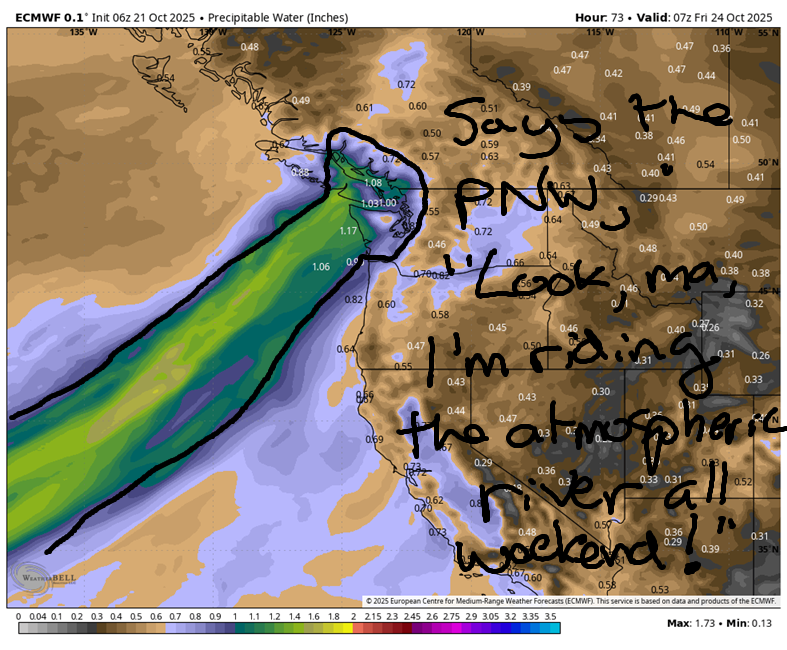
Good morning, neighbors! Another beautiful fall day is on tap for Tuesday. Dry weather (mostly dry, anyway), continues through Thursday. Starting Friday, probably around midday, rain arrives. Not just a little rain. Nope. This weekend taps into an atmospheric river… or should I say, an atmospheric river taps the PNW… penetrates it… pounds it… However you phrase it, it’s going to be as wet as… (insert some sort of se*ual comment here)
Glenwood this morning
Even in Glenwood. Even there it will be wet. But not this morning. This morning it’s clear and 28 degrees in Glenwood. Everyone is sitting on their porches shaking their heads and wondering why the damned they/them weather forecaster can’t talk weather without talking cock.
Today’s Gorge weather forecast
Down in the valleys to start today (Tuesday)… a little bit of Nothing cloud here and there thanks to the temperature meeting the dewpoint in a few spots. We’ll see a mostly clear day today with temps rising to the upper 60s most lowland locations. Calm wind this morning gives way to easterlies at 20mph at Iwash (prick) Rock, Stevenson, and Viento with light easterlies to the east. Just enough high clouds arrive this afternoon to add a bit of color to the sunset.
Wednesday’s Gorge weather forecast
Sunrise Wednesday: also colorful thanks to a few high clouds. A weak system pushes inland during the day and adds low clouds to the west and a mix of mid and high clouds to the east. After an east wind start (usual spots: 20mph), we finish with westerlies. West of Mosier, expect 15-20mph. East of Mosier to Arlington’s Triangle: 20-25mph. High temps will be in the mid 60s to the west and upper 60s near The Dalles.
Thursday’s Gorge weather forecast
Thursday looks cloudy and dry most places. West of Cascade Locks, there could be a little afternoon mist or drizzle, just enough to send the naked people naked tanning at Pen*s Rock running for home. Know what’s funny? What wieners do when their owners are running! Temps Thursday max out in the mid 60s. Wind: light and variable.
Extended Gorge weather forecast
Starting midday Friday, we’ll see rain. Details aren’t all sorted out yet (thanks to the govt shutdown, nobody is supervising Ma Nature, and she’s being a bit coy with her plans), but it’s gonna be real wet through Sunday night. Maybe she’s being coy because her plans involve strapping on a strap-on and pounding the PNW all weekend long. She was probably afraid the anti-LGBTQ crowd (probably the same ones in the YR texting about Na*is and gas chambers… and FFS, I’m Jewish, and the prevalence in the Republican party of that kind of talk is horrifying) would rain on her plans. Ma Nature: love whoever you want to love in whatever way you want to as long as full consent and a “fuck yeah” attitude is involved.
Back to the rain… it continues on and off, heavy at times, all the way through late Sunday. In a fun twist, we get to talk about snow too! On Saturday, the snow level falls to 4500′, and then falls as low as 3000′ overnight into Sunday. It’s likely the snow level will stay below 5000′ all the way through Monday. While the total precip amounts aren’t available yet, 1-2 FEET at 5000′ seems totally possible. My fingers are crossed. Hopefully none of the threads are crossed on my bolts, because I may have to throw on my snow tires and go for a ski! You traveler people: expect snow on the passes Saturday onward. Also expect strong wind and blowing snow in the mountains from Saturday midday into Sunday evening. Winter is here, at least for the mountains. Safe travels. -TATAS
HEY! DON’T STOP READING! Is this community-focused forecast helpful to you? It sure is! It takes me a couple hours a day to write. Please join your friends and neighbors in contributing to keep it going. Venmo: @thegorgeismygym PayPal: twomirrors@gmail.com USPS: Temira / PO Box 841 / Hood River, Oregon 97031 You can test out the forecast subscription for a few days for free by signing up below. Easy! Do it!
MT HOOD SNOW FORECAST

CURRENTLY ON VACATION. WILL RETURN SOMETIME BEFORE THE START OF SKI SEASON AT MEADOWS, TIMBERLINE AND SKIBOWL. SAME GOES FOR THE NORDIC SKIING SEASON AT MEADOWS AND TEACUP!
JONES BEACH, SAUVIE ISLAND, & COAST FORECAST
ON VACATION FOR THE WINTER. MAY SHOW UP OCCASIONALLY IF NEEDED.
